For scientists searching for evidence of the most ancient life on Earth, there are just four places on the entire planet to look. Only in Québec, Labrador, Greenland, and East Antarctica is it possible to find sedimentary rocks dating back to the Eoarchean age, the era when life on this planet had just begun, more than 3.6 billion years ago.
The fossil in question came from a belt of rock in Québec, which was formally dated only in the past couple of decades. This particular rock belt is isolated enough that, after these rocks were first investigated in the 1960s, there had been little work done to map or date them until a team of Canadian geologists started to explore the area in the late 1990s. Once that team started determining the rocks' ages, though, it was clear they were really, really old.
Travel to the remote reaches of northern Québec, and it's possible to walk on this ancient rock. "We don't have to drill or anything. The rock is completely exposed to atmosphere," says Dominic Papineau, a lecturer at University College London, who collected the samples used in the new study back in 2008. Until about 8,000 years ago, the rock was covered by the ice sheet that once stretched down to what's now the northeastern United States, but when the ice sheet receded, it left the rocks exposed and polished. There's little soil or vegetation there now. Most of the area is dominated by volcanic rock, but there's a stretch a little under 2 miles long of sedimentary rock, where traces of life from 4 billion years ago have a slim chance of surviving.
These rocks were first formed from an oozy layer of underwater sediment, where microorganisms could thrive. At some point, that layer of sediment mineralized and turned into rock, which was layered into an ancient piece of continental craton, a large chunk of the earth's crust. In some places in the world, pieces of the earth's crust move against one another so that one is pushed under the other, which starts the crust melting, creates volcanos, and destroys any evidence of ancient life in sedimentary rock. These most ancient pieces of sedimentary rock most likely survived because they were hidden deep inside a craton. They are small relics of the earliest history of our world: almost all of the rock that was around then has either disappeared, through erosion, or been transformed through metamorphosis.
Some of these ancient rocks were discovered decades ago. In Greenland, scientists first identified Eoarchaen rocks in the 1960s and ’70s, but, even though they were well-known, those rocks hadn't always been accessible. One discovery, reported last year, came from a Greenland site that had been revealed in an unusually warm spring, when rain washed away the snow.
"That's possibly one of the only positive outcomes of climate change," says Papineau. "The ice sheet in Greenland has been melting, and it liberates and exposes this bedrock." If there are more ancient rocks that have lasted through the ages, they may be hiding under the ice in Greenland or Antarctica.
Once such places are located, scientists like Papineau look for promising spots to sample, where the composition of the rock contains signs of life. Papineau sampled the rocks in the new study from a very small outcrop that stood out in the expanse of dark grey and green in the Québec rock belt. "There was a very localized place along the strike of this big unit," he said. "It was red." Right near it were rocks colored orange. These unusual colors indicated a concentration of iron, which is associated with ancient microorganisms. That's how he knew he had to take a piece back to the lab.
Batgirl has had enough with the jokes about her salary.
In the 1973 clip above, archived by the U.S. National Archives, the characters Batman and Robin from the 1960s Batman television series are strapped to a pole and await their demise from a ticking time bomb. Batgirl bursts onto the scene, strikes a power pose, and then proceeds to admonish the trapped men. As one of Batman's crime fighting partners and an equal part of the "Terrific Trio," the heroine demands equal compensation.
"I've worked for you a long time and I'm paid less than Robin," Batgirl, played by actress Yvonne Craig, tells Batman. "Same job, same employer means equal pay for men and women."
The United States Department of Labor Wage & Hour Division's public service announcement encouraged women to exercise their rights and use the Federal Equal Pay Law. Even though the show had been off-air since 1968, Dick Gautier (who filled in for Adam West as Batman), Burt Ward (Robin) and Craig reunited for the announcement to deliver the important message. Over 40 years later, Batgirl's statement and efforts are still at work.
After standing up to Batman and Robin and proving that the team would be toast without her, Batgirl disarms the bomb and saves the day.
Every day we track down a Video Wonder: an audiovisual offering that delights, inspires, and entertains. Have you encountered a video we should feature? Email ella@atlasobscura.com.
They are not America’s art police. There are no midnight raids, covert surveillance or undercover operations. Most everything is done through cordial emails, polite phone calls and, if necessary, civil court. While glamour is not top priority, make no mistake: The United States government wants its art back.
Special Agent Eric Radwick, who works in the Office of Investigations for the General Service Administration’s Office of the Inspector General, is working to do just that—to locate and recover government-owned long-lost artwork of the New Deal-era federal arts programs. It could be hidden in plain sight. It could be in grandma’s attic. It could be in the possession of art collectors. No matter if it was found in the trash or cost a few grand, the art is federal property and the government is looking for it. That means regularly monitoring auction house listings, Craigslist and eBay. It means coordinating with the art community about tips. It also means waiting for calls to the GSA hotline.
Most people, upon realizing they are in possession of federal property, are cooperative. Few are not, understandably reluctant to give up art that’s been in their family for decades. But as Radwick likes to say, “My uncle also lost a lot of art many years ago. My uncle just happens to be Uncle Sam.”
On May 9th, 1933, President Franklin Delano Roosevelt received a rather curious letter from an old classmate and professional artist George Biddle. Since his March inauguration, President Roosevelt had implemented the most aggressive 100 days agenda in the country’s history in hopes of solving the Great Depression. While absurdly busy—he had just delivered his second Fireside Chat and was about to sign both the Farm Relief and Unemployment Relief bills—this note gave him pause. In it, Biddle wrote that he had long admired the Mexican government for paying artists “plumbers’ wages” to paint murals on government buildings expressing Mexican ideals. Perhaps the President should consider something similar in the United States?
As Biddle wrote, “[Artists] would be contributing to and expressing in living monuments the social ideals you are struggling to achieve. And I am convinced that our mural art, with little impetus, can soon result, for the first time in our history, in a vital national expression.” In his diary, Biddle admitted that he really didn’t know Roosevelt all that well—save for encountering him at the school infirmary where “boys who were underweight were served crackers and milk”—but the letter got the President’s attention. A month later, Biddle met with members of FDR’s administration in Washington about his proposal. By the end of 1933, the first national art relief program—the Public Works of Art Project—was established.
Over the next decade, the American art scene flourished thanks to the financial encouragement of the government. According to Smithsonian Magazine, in the first four months of 1934 alone, nearly 4,000 artists were hired to produce over 15,000 paintings, murals, sculptures and other works of art for federal buildings across the country. In 1935, the Works Progress Administration’s Federal Art Project was established, the largest of these programs both in scope and number of artists employed. In its eight-year existence, it’s believed that over 200,000 artworks were created under the project while employing such before-they-were-famous luminaries as Mark Rothko, Marion Greenwood and Jackson Pollock. At a time of crisis in America, these programs not only provided an enormous collection of artwork for public consumption, but gave the creators a sense that they were needed. “It made them feel like they counted,” says Virginia M. Mecklenburg, Chief Curator at the Smithsonian American Art Museum , “What they did and created had ... value for the country and their fellow Americans.”
A few of the pieces produced for these programs are considered American masterpieces, like Marvin Beerbohm’s Automotive Industry mural, the “Scrub Woman” ceramic sculpture by Gustave Hildebrand and John Sloan’s Fourteenth Street at Sixth Avenue. Many, many more are not. As Mecklenburg points out, these programs were all basically work release programs—after all, those who applied had to prove they were impoverished and actual working artists. Often, artists were assigned projects by either federal, local or regional agencies to create works for particular federal buildings or public institutions, like libraries, schools, housing projects or the Department of Interior. Their latitude in picking the subject matter and how they went about creating it was rather limited.
However, says Mecklenburg, “[their work] helps us understand who we were and what we thought at a particular time ... It’s not art about art. It’s art about us.”
The works are also all federal property, commissioned and paid for by the United States government. According to the GSA’s legal fact sheet, the courts have determined that at no point can the federal government abandon property—even due to “inactivity” or “neglect.” When it comes to Federal Art Project works, the “GSA recognizes that there have been many stories of works of art abandoned or even thrown in the trash,” but the “GSA does not believe the employees of the New Deal agencies were authorized to treat the property of the United States in this manner.” Furthermore, because all of these murals, paintings, and sculptures, were funded by taxpayer dollars, the art is required to be loaned to and displayed in a place where “the public has access free of charge and which are ... operated exclusively for educational, scientific and charitable purposes.”
This is why the GSA’s Fine Arts Program—and Special Agent Radwick—are in hot pursuit of these works of art. And there are a variety of reasons that they have gone missing in the first place, a few more innocent than others. Sometimes the government simply lost track of them, like the several Sophie Brannan landscapes that were “rediscovered” hanging in a San Francisco public library in 2015. Or a piece of artwork is not immediately recognized as valuable or government property, like in the case of Anne Fletcher’s Iris Garden. The story goes that in 1970 a 12-year old Berryville, Virginia student was told by his principal that, as a reward for helping to clean out the soon-to-be demolished high school, he could take home whatever art he could manage to carry in one trip. One of the pieces he took was Fletcher’s beautiful garden landscape. It hung in his home for four decades before he realized what he had was a forgotten classic (thanks to an episode of Antiques Roadshow).
Recognizing New Deal artwork is not as easy as it may seem. With any luck, there’s a brass plate on the frame that reads “WPA Federal Art Project” or a paper label on the back that indicates completion date, artist and title of the piece. Unfortunately, that’s not always the case, explains Jennifer Gibson, Director of GSA’s Art in Architecture and Fine Arts Division, who helps authenticate the works. A painting could be missing its original frame, the paper label could ripped off (intentionally or unintentionally) or other verifying documents could have been lost over the years. When that happens, they have to sort through decades-old paper records that are voluminous, unorganized and often not centrally housed—meaning, depending on the work’s original destination, the records could be at the National Archives or in other state, city or institutional archives around the country. As Gibson puts it, “It’s definitely a ‘needle in the haystack’ problem.”
Radwick says this is one of the GSA’s feel-good programs, in that they are bringing the art back to the people—even if a majority of the works are sorta pedestrian. “For some of this stuff, the beauty is truly in the eyes of the beholder,” says Radwick with slight chuckle, though he describes certain works, viewed up-close, as “truly awe-inspiring.”
According to the GSA’s most recent report to Congress and since the project began in 2001, 578 WPA works of art have been recovered with a comparative value of $6,659,350 (with John Sloan’s Fourteenth Street at Sixth Avenue leading the way with an estimated value of $750,000). After reacquisition, they are often re-loaned to various institutions, museums and public buildings across the country. Examples include Dorr Bothwell’s Steam Shovel, now at the Los Angeles County Museum of Arts, The Accident by Adrian Troy, at the Illinois State Museum and Virginia Pitman’s Four Phases of Labor, which lives at the Wyoming Museum of Art.
Radwick also notes that they make every effort to work with the possessor to get the artwork loaned to a nearby institution, as they did with a Michigan man who had bought a WPA-marked Leonard Jungwirth sculpture at a local antique mall. He requested that it be displayed at nearby Michigan State University with a plaque mentioning both him and his sister, who had attended the state college. Radwick says it was the least they could do considering the government can’t compensate individuals to get its property back, even if the artwork “has been in the family for years” and its owners “were planning to sell it for a college fund for [their] kids or grandkids.”
Who will save the helpless ducklings?! The City of Indianapolis, that’s who. Recently the city installed a series of small ramps to stop an epidemic of dead ducklings in one of their canals.
As Fox56 is reporting, the city of Indianapolis built and installed four ramps at points along its popular downtown canal to help young ducks and geese climb over the thick concrete edge. Last year the city was alerted to a number of dead ducklings in the canal which seemed to have passed away, having been unable to leave the water.
The mini-ramps are made of wood and insulation, so they can float along the surface of the water, and the tiny birds can easily board them.
It’s so far unclear the exact impact this will have on the lives of ducklings in the canal, but PETA praised the move, saying that the city, "doing the right thing in striving to coexist with local wildlife." So if you’re in downtown Indianapolis, be sure to watch your step. The ducklings can make it to the street now.
Mt. Tateyama rises 9,892 feet in Japan’s Hida Mountains and is considered one of the country’s Three Holy Mountains. It also may be one of the snowiest mountains in Japan, and perhaps one of the snowiest places on planet Earth.
The Hida Mountains are part of the Japanese Alps and meteorologists suspect that parts of the range receive as much as 1,500 inches of snow a year, or 125 feet. Piled continuously, that would be snow nearly half as high as the Statue of Liberty.
Amazingly, there is a highway that runs through a part of this epic snow country. Route 6 begins in the 1.1-million-person coastal city of Toyama, approaches the western flank of Mt. Tateyama, then disappears into a tunnel. The route eventually emerges on the other side of the Hida Mountains, in Nagano Prefecture, where the 1998 Winter Olympics were held. But just before the road enters the tunnel—and just after it passes the remote and The Shining-esque Tateyama Kokusai Hotel—it runs for about a quarter-mile along the base of a broad ridgeline. In Japan this particular stretch of highway is known as yuki-no-otani, or Snow Canyon.
The height of the canyon’s snow walls can reach a staggering 66 feet. Using another New York City analogy, that would leave your average five-story East Village walkup apartment building buried head to toe in snow.
“The amount of snow that falls here is just exceptional,” says Yoshihide Tanikawa, Vice President of the Toyama Prefectural Road Public Corporation, which is in charge of snow plowing across many parts of Toyama Prefecture, including the Snow Canyon. The reason behind the tremendous snowfall is a confluence of geography and meteorology. “Toyama is on the coast with an elevation of zero,” explains Tanikawa, and just 20 miles from the ocean is Mt. Tateyama. “So the altitude rises from sea-level to 3,000 meters [9,843 feet] in a very short distance.”
Every winter the western part of Japan, what has come to be known as Snow Country, experiences a winter monsoon. Frigid Siberian air streaming south and east across the relatively warm waters of the Sea of Japan generates snow clouds, which unleash their flakes as they approach land. The phenomenon is similar to lake-effect snow in the U.S. But while the Great Lakes can freeze over, effectively shutting off the snow machine, the Sea of Japan stays open all winter long. Coastal mountains such as Mt. Tateyama amplify the snow.
Syracuse, New York, often dubbed the snowiest city in the United States, receives, on average, 117 inches of snow a year. Japan’s snowiest city with a population over a million is Sapporo, on the northern island of Hokkaido, which checks in at 235 inches a year. Japan’s snowiest city with a population over 300,000 would be Aomori, on the northern tip of Japan’s main island of Honshu, coming in at 263 inches a year.
Heading further down the list the numbers skyrocket. Tokamachi is Japan’s snowiest small city, with a population of about 54,000; it gets 460 inches of snow a year. And Sukayu Onsen, a traditional Japanese hot spring resort high in the Hakkoda Mountains, and not far from Aomori, is the snowiest inhabited spot in Japan—and perhaps in the world. Sukayu’s annual tally: a stupendous 695 inches. That’s 26 times more snow than New York City receives in a winter, and more than six times as snowy as supposedly snowy Syracuse. Perhaps just as remarkable, the road to Sukayu Onsen is open year-round. The question arises: How on earth does Japan remove all of this snow, and not be plagued by a winter of continual snow days?
“This is a job and someone has to do it,” says Takuma Igarashi, a Japanese snow plow driver of more than 20 years. “We might be doing it in the shadows, but it’s for the benefit of everyone.” Igarashi, who recounted his experiences while dressed in red sneakers, a thick work jacket with a yellow reflector vest and a hardhat, presently plows snow in Toyama, the coastal city where the road to the Snow Canyon begins. Toyama’s snowfall is not as grand as many spots in Japan, but this city of more than a million people still gets 144 inches a year. When told that New York had closed schools across the city last February for a storm that dropped nine inches of snow (23 centimeters), Igarashi laughed.
“Here in Toyama sometimes you’ll have 20 to 30 centimeters of snowfall in just one night,” he says. To ensure roads are clear for the 6 a.m. Toyama commute, Igarashi and a crew of hundreds of other snow plow drivers work through the night. “If we don’t remove the snow,” he says, “no one would be able to pass.”
At the Snow Canyon, the non-human star of the show is the HTR608, a rotary snow blower made by the Nichijo company—the 608 refers to the 608-horsepower engine. The HTR608 can plow through snow up to six feet high. The rotating bar helps pull snow into the machine, and a powerful propeller ejects it out of an aerodynamic pipe that can spray the snow nearly 50 feet high and half a football field to the side. But before this monster can even begin its job on the Snow Canyon, a series of prior snow-clearing events must take place.
Mt. Tateyama receives too much snow and is too remote to receive continual snow plow treatment, thus for much of the winter snow is allowed to bury the pass. Sometime in early March, a bulldozer specially equipped with both a GPS and a mobile satellite phone is sent up the mountain and over the Snow Canyon. The GPS and sat phone work in tandem to provide the driver a detailed video screen image of the dozer’s location in relation to the center of the snow-buried highway. This driver’s job is not to clear snow, but simply to lay out an accurate track of the road itself. Following the GPS dozer is a team of dozers that will begin the clearing operations. The first bulldozers will push and carry the snow forward, to areas where depths are lower and it can be pushed aside or dumped. Backhoes are used to help widen the road. When the bulldozers have come within six feet or less of the road, the rotary blowers can begin their work, and help to at last reveal the long buried asphalt.
To plow the 14-mile section of road that runs from the edge of Toyama and through the Snow Canyon takes about a month. By mid-April the Snow Canyon is typically ready for tourists. Last year, 270,000 people visited. “Originally, removing the snow was just to be able to bring people and supplies to the Tateyama Kokusai Hotel,” says Tanikawa, “but then we realized that we have something fairly exceptional, and why not bring people to see the walls.”
But whether the Hida Mountains, and Japan in general, will continue to receive epic snowfall as the world warms is another question. Dr. Hiroaki Kawase, of the Japan Meteorological Agency, has researched the issue. As temperatures rise, snowfall across the west side of Japan should decrease, Kawase reported, in a November 2013 study published in the Journal of Geophysical Research. But the decrease will be much more pronounced at lower elevations, such as Toyama, where much of the city’s snow falls with temperatures near the freezing mark. A few degrees warmer here will make a big difference. Higher elevations will likely continue to have exceptionally snowy winters, at least in the short term. Still, the culture of Japan’s Snow Country may already be changing.
“I remember when I was in high school there was a lot more snow,” says Tanikawa, who is now 50. “In the morning snow fell and it would fall all day while we were at school. When I came back home there would be 40 to 50 centimeters of snow to clear.”
“My children,” Tanikawa adds, “have not had that experience.”
I was astounded; 40 to 50 centimeters of snow is about 16 to 20 inches, and I wondered if it had ever snowed enough—and more importantly, the snow having outpaced the snowplows—for Tanikawa to have experienced a snow day as a child.
Two teams of scientists have successfully created “time crystals,” a state of matter first proposed in 2012. One team used the element ytterbium to created its crystals; another used diamond packed with nitrogen impurities. Both teams were able to show how the atoms in their crystals followed a pattern that repeated in time, rather than in space.
Think about it this way: in the states of matter we’re familiar with, atoms line up in certain, predictable ways that repeat over and over again across space. Time crystals do the same thing, but their atoms line up in certain, predictable ways that repeat over and over again across time.
The teams created the time crystals by zapping their elements with energy (an electrical field in one case, a microwave field in the other). The ions in the crystals started regularly flipping back and forth. But the rhythm of the movement didn’t match the rhythm of the energy being added to the system. The crystals had a preferred rhythm that they stuck to.
On a practical level, time crystals could contribute to the advance of quantum computing. On a "oh-holy-wow" level, this is, as the physicists who did the research say, “a new phase of matter."
Up near the northwest corner of Alabama is a four-square-mile town called Phil Campbell. There is also a New York-based writer named Phil Campbell. Together, they’ve been able to create a loose international community of Phil Campbells that share a single bond: their name.
The Alabama Phil Campbell got its name from an English railroad engineer. As the story goes, that Phil Campbell was building rail lines through Alabama in the 1880s when a local businessman told him that if he would build a depot in the area where the town still stands, he would name it after him. Campbell obliged, and the businessman kept his word, making it one of only a handful of towns in the U.S. to go by a full person’s name. Campbell himself never ended up living in the place that still bears his name.
As of 2010, the town has a population of just over 1,100 souls.
Now meet Phil Campbell, a writer currently living in Queens. “I’m Brooklyn Phil, and I’m going to be Brooklyn Phil. Some of [the other Phils] will say Queens just to mess with me, because they think Queens is funny,” says Brooklyn Phil (which is how we will refer to him going forward, for reasons that will soon become obvious).
Brooklyn Phil first discovered the town of Phil Campbell when he was in college back in 1993. “I was drinking and dateless on a Saturday night with my college roommates, and there was a random moment where we found Hee Haw,” says Brooklyn Phil. “We really just wanted to see somebody pop out of that corn field. Instead, there was a moment where they used to give a shout out to a small town in Middle America, and they said “HOWDY!” to the folks of Phil Campbell, Alabama.”
Brooklyn Phil and his roommates quickly went to their road atlas, and sure enough, they learned that Phil Campbell, Alabama, was a real place. “It was just such a seductive idea. A town having your name,” he says.
Brooklyn Phil travelled to Phil Campbell for the first time that next summer, in 1994. “I did what every other Phil Campbell has done in that town, which is take a lot of photos. Next to the police cars; a couple of water towers have the name. Anywhere there’s a name. I also just wandered around the town randomly talking to people,” he says. During that first trip, he also discovered that the county clerk had kept a yellow file folder of business cards and news clippings about all the Phil Campbells who had come to the town previously. This gave him the idea to put together the first ever Phil Campbell Convention.
Returning home from his visit, Brooklyn Phil looked up all of the Phil Campbells he could find with registered phone numbers (off of a CD-ROM directory! The ‘90s!). Identifying about 330 Phil Campbells across the nation, he began blindly sending out letters to each one. He included a copy of an article about the town that he had written for his college newspaper, and some information about his proposed meet-up. “People wrote back. People left voice mails. Enough people responded from such a diverse number of places, I just thought, ‘I have to do this.’” he says.
The first Phil Campbell Convention took place in June of 1995. In addition to Brooklyn Phil, 22 other Phils, and even a Phyllis, converged on Phil Campbell for the weekend to hang out and commiserate over their shared Phil Campbell-ness. Phil Campbells came from Idaho, Colorado, Pennsylvania, and other parts of the country, identifying each other by their hometowns. According to Brooklyn Phil, they ranged in personality from beer-downing good ol' boys to mysterious recluses (one tragic Phil, who had lost his wife and hardly left his room the whole weekend, was a particular focus of discussion among the others). They drank, and grilled, and shared their stories. “All these themes of community, and ‘what is community?’ Those were all really strong in the first Phil Campbell convention in ‘95,” says Brooklyn Phil.
All the while, the mayor of Phil Campbell did everything he could to keep the visiting Phils happy, thinking of the modest convention as a possible boon to the local economy. A few national press outlets picked up the story, and the mayor even honored Brooklyn Phil for putting the whole thing together, “The mayor at the time gave me an honorary citizen certificate. I was hoping for a key to the city.”
At the end of the weekend, the Phils scattered back to their home states. Brooklyn Phil wrote an in-depth article about the experience, which was published in the now-defunct San Francisco magazine Might, and began to move on with his life.
The town of Phil Campbell, or at least the mayor, wanted to keep the tradition going and tried to organize another Phil Campbell convention the next year, but only eight Phils showed up. As Brooklyn Phil tells it, the rest of the town began to get pretty salty about all of the attention the out-of-town Phils were receiving from the mayor. After a couple of years, the idea of the Phil Campbell Convention was replaced with an annual Hoedown celebration that focused more on the town itself and its people. “It didn’t occur to me when I was that young that I would be able to create an event that would involve a whole town. Had I been better prepared, that totally could have been a festival from the beginning. Bringing Phils and the residents together,” says Brooklyn Phil.
Both the town of Phil Campbell and Brooklyn Phil moved on. The Hoedown continued to be celebrated each year, while Brooklyn Phil pursued his career in journalism, eventually taking a detour into politics (which resulted in a book and a movie), and landing him in Brooklyn in 2004.
But the Phil Campbell siren song came to Brooklyn Phil again in 2010 after he stumbled on the town’s Wikipedia page, which included a handful of somewhat incorrect references to the original convention. It occurred to him that in the new world of social media, he could finally do the convention again, the way he’d always wanted to do it, with Phil Campbells from all over the world. Finding Phil Campbells from Australia to Chile, he began sending out messages across Facebook. His sister suggested that he set a goal of connecting with every single Phil Campbell in the world, which garnered his campaign attention from news outlets including the BBC and The Wall Street Journal. It was during this effort that he finally earned his nickname, “Brooklyn Phil.”
Brooklyn Phil reconnected with the town management, and they planned a convention to take place as part of the annual Hoedown in June of 2011, which would also mark the 100th anniversary of the town’s incorporation. The stars seemed to be aligning for a bigger, more global convention than before, which would also pay respect to the town. Then, on April 27, 2011, the town of Phil Campbell was hit by a massive EF-5 tornado.
Whole swaths of the town were obliterated, and 27 people were killed in the storm. Initially the Hoedown was called off while the town focused on its recovery, but then one of the Phils who'd been planning on heading to Alabama for the Hoedown suggested to Brooklyn Phil that the Phils turn the convention into a relief effort. Literally, “Phil Campbells Helping Phil Campbell.”
Brooklyn Phil was able to convince the town to reinstate the Hoedown, and he got on the phone with more media outlets, hoping to increase interest in fundraising to support rebuilding efforts.
On a June weekend, 20 people named Phil Campbell came to Phil Campbell, Alabama, this time to help rebuild. A handful of Phils who'd attended the 1995 convention returned to help out, including a man from Wisconsin called Big Phil, who spent the days breaking down debris like he was born to it. There were a handful of Phils from Australia, one from Scotland, another from England. Together they worked at cleaning up and clearing the demolished pavilion and swimming pool where the first convention had taken place, before taking part in a small parade and town festival.
While their efforts had a good hook, the Phils were far from the only groups who came to help Phil Campbell. “It’s hard to take too much credit for it. There was a group of Mennonites who drove down from Pennsylvania right after the tornado hit, and they just started building houses. There are lots of stories of people stepping up to help other people,” says Brooklyn Phil.
By the end of their efforts, the Phils had managed to attract international media attention and raise enough money to fund a Habitat for Humanity house. “We’d raised something like $42,000, which wasn’t bad for six weeks from 20 random guys,” says Brooklyn Phil. “We’re not coming from big money or anything, we’re just Phil Campbells.”
After that weekend in 2011, the Phils once again scattered back to their respective homes, but a great many of them now continue to stay in touch. If a Phil Campbell has an album coming out, the rest of the Phil Campbells in the community will do what they can to support it; if a Phil Campbell is passing through another Phil Campbell’s city, they will often try and meet up. And in at least one case, if a Phil Campbell is having medical trouble, others will try and raise money. All because they share a name.
A documentary about the relief efforts, I’m With Phil, was released in 2014, playing multiple times on Alabama PBS stations, and making Brooklyn Phil somewhat of a local celebrity in the state. But he’s still an outsider. “I think I’m sort of seen as the weird uncle from New York, because I’ve a very strong liberal political bias,” he says. “I post a lot of stuff and I’m not stopping posting stuff on Facebook, and a few people have stepped up to argue with me. It is a strange sort of relationship, because I’m not the usual sort of person they normally get to know.”
Brooklyn Phil and other interested Phil Campbells now plan to reconvene in Phil Campbell every five years, having just gone there again in 2016 to clear a walking path. The town no longer keeps a file of clippings and cards, but they still honor the Phils who pass through. Around 2014, a wooden sign (built by Birmingham Phil, from nearby Birmingham, Alabama) was installed that features directional arrows to all of the far-flung places visiting Phil Campbells have hailed from.
At the next scheduled Hoedown, in 2021, the Phils plan on adding a new arrow for Webster, New York. “We’re adding one for a Phil Campbell who passed away [around] 20 years ago. But his sister and his wife made the trip to Phil Campbell, Alabama, because that was on his bucket list at some point in his life, but he never made it out,” says Brooklyn Phil. In the meantime, the new arrow is being passed around the Phil Campbell community, many taking pictures with it in their hometowns, before it gets installed in Phil Campbell. Ultimately, the Phil Campbell community remains drawn to Phil Campbell, Alabama, and to one another.
After a storied career that saw it appearing in Game of Thrones, various tourism brochures, and the daydreams of many deskbound workers, Malta's Azure Window fell into the sea Wednesday, the Times of Malta reports.
The so-called Azure Window—formal name Tieqa tad-Dwejra—was a massive limestone arch that connected two large seaside cliffs on Gozo Island. People came from around the world to clamber over it, and to gaze through it at the sea and sky beyond. Both the arch and one of the cliffs it connected collapsed yesterday, effectively severing the whole feature from the coastline.
Recent studies indicated that the arch would likely not survive long, due to corrosion from wind, waves, and walking. In response, the government outlawed climbing over the arch last year.
In the end, though, the arch's demise was entirely natural, the result of a massive storm. "There was a big raging sea beneath the window," Malta resident Roger Chessell told the Times. "Suddenly, the arch collapsed into the sea with a loud whoomph. By the time the spray had faded, the stack had gone too."
In 1996, Volkswagen began making the rounds for the North American auto shows with a new color of its four-door Golf hatchback. Well, not “a” new color, really: the car that would come to be known and prized as the VW Harlequin Golf is a four-color car: each door panel, the two bumpers, the hood, and the roof were painted in either purple, yellow, teal, or red. No one panel could be touching another of the same color. It looks like somebody disassembled four Fisher-Price toys and reassembled them while wearing a blindfold. It is probably the sickest car I’ve ever seen.
The Harlequin Golf made such a splash that VW eventually placed an ad asking the public if this should be a real car, that real people could buy. The response was an overwhelming “yes,” and VW eventually made, it seems, 264 of them, in a couple different configurations. Today the car pops up on message boards and Facebook groups about obscure cars, and sells for more than five times as much as an equivalent normal Golf from the same year.
I have become obsessed with this car. I have very seriously thought about flying to Florida to buy one. There’s something about those big, bold blocks of color that just grabs me. But what is it? Why does this insane, non-matching car feel so cool and fresh?
The Harlequin Golf’s styling is a textbook example of something fashion people call “colorblocking.” “Colorblocking to me is deliberately wearing a bunch of different complementary and contrasting colors together, without doing it in a print or a pattern,” says Connie Wang, a senior features writer at Refinery29 who has written quite often about colorblocking. “So picking individual items that are different colors and wearing them together, or one garment that has solid blocks of different colors on it.”
Colorblocking isn’t really something that can easily be traced to its starting point; it’s a basic enough concept that trying to find the originator of colorblocking would be kind of like trying to find the person who invented stripes. But it certainly had its heyday in particular eras of fashion and design.
The first major example of the modern conception of colorblocking comes in designer Yves Saint Laurent’s 1965 collection inspired by the paintings of turn-of-the-century Dutch painter Piet Mondrian. Mondrian is best known for his paintings of irregular grids of thick black lines in which some of the intersections are filled in with primary colors. Saint Laurent’s dresses were pretty literal translations of these paintings into simple dresses: big black lines, blocks of bold color.
Though Mondrian’s work had been done decades before, the 1960s were a good time to revisit it. Pop Art, with its artificially intense colors, often used a technique called “hard-edge painting.” Hard-edge painting is pretty much what it sounds like: colors do not blend into neighboring colors, but instead form firm borders. Basically: red next to blue, in which red and blue remain completely separate and do not meld.
Colorblocking, like a lot of fashion ideas, went in and out with the decades. In the 1990s, it evolved to primarily focus not on one garment with different blocks of color, but many garments, each one with its own color. Big designers in the mid-1990s went crazy for this: Isaac Mizrahi and Versace both released bold, vibrant colorblocked shows right around the time that the VW Harlequin Golf was created.
It came back strong, says Wang, around 2011. “It was a big internet trend, there were a lot of YouTube videos and articles made about how to do colorblocking correctly,” she says. “I wrote about it constantly in like 2012. It was consistently a big SEO keyword for us.” (SEO refers to “search engine optimization,” basically trying to figure out what terms people are Googling and catering to those.) Today it’s more subtle. “Right now the big thing is monochrome, which is kind of the same idea, just a little more limited,” says Wang. Instead of wearing a pink shirt and teal pants, you might wear two different shades of white, or red, or tan. It’s in the same family as colorblocking, just maybe a bit more subtle.
Colorblocking is a theme fundamentally opposed to itself. It is a maximalist minimalism. In the 2010s, fashion tends to be heavily minimalist, defined by a paring down of excess. Not too many different pieces, few if any accessories, basics like jeans and t-shirts and button-downs. The problem with minimalism is that it can have the feeling of joylessness; many minimalist getups rely not just on basic designs but on basic colors. Blacks, whites, greys, neutrals. Blech.
What makes colorblocking so appealing is that it is a minimalist point of view. “Actually, the more minimal and basic each piece is, I think the better the overall outfit is,” says Wang. A simple t-shirt, a simple pair of jeans, a simple jacket and sneakers—that outfit can become intense and exuberant if each item is its own vibrant color.
All those guides to colorblocking make it clear that, for this 2011-era of the style, you want as much conflict as possible. Take a look at a color wheel, an ancient creation borne of Isaac Newton’s understanding of the relationships between colors. The color wheel is set up so that colors on the opposite sides of the wheel would, if combined, create a neutral: black, brown, white, grey, somewhere in there. These are sometimes called “opposite colors” or “complementary colors.” You probably remember this from elementary school.
For maximum impact, basically every colorblocking tutorial instructs you to mix these complementary colors. Yellow and purple work well, in addition to those blue/orange and red/green constructions. But we don’t have to stick to scientifically opposite colors; our goal here is to shock the eye with huge contrasts. So neutrals and fluorescents work well: hot pink and brown, say, or neon green and khaki.
Another fundamental element of colorblocking is its accessibility. Wang described the kind of person who likes, or liked, to colorblock as someone more interested in the creative aspect of fashion than the status aspect: a person who would shop at thrift stores rather than designer boutiques. This is a style that can be done by anyone, because the value of each individual piece is much less important than the impact the outfit has as a whole.
That VW Harlequin Golf, weirdly, is a perfect example of this. My first assumption when I saw that car was that Volkswagen had simply painted the car with different colors. But that turns out to not be the case at all. What VW did was make a purple Golf, a yellow Golf, a teal Golf, and a red Golf, and then took it completely apart, scattered the parts around, and reassembled it from parts of all four cars. The Harlequin Golfs tend to be referred to by their “base color,” meaning the color of their roof and a bit of their sides. The doors, hood, and bumpers, though—those all came from completely different cars.
And that’s the key to why colorblocking works, and why we like it. A colorblocked piece—whether that’s a painting, a car, or an outfit—is simple in all its component parts, and yet blasts you with complexity as a whole. It’s a technique that allows for a maximum of experimentation, and yet requires basically nothing in the way of initial investment. It’s a mark of originality without being weird: after all, that Golf is just a Golf.
Steadily, from the muddy ground of a modern Cairo neighborhood, a giant statue emerged. The archaeologists who discovered this massive likeness, which would have been an estimated 26 feet tall in its original form, think it depicts Ramses II, Ozyamandias, the Great Ancestor—one of Egypt’s most famous and celebrated pharaohs.
The country’s Antiquities Ministry is saying that this is among the most important archaeological finds ever made in Egypt.
Ramses II ruled more than 3,000 years ago, during the period of the New Kingdom, when Egypt was at its most powerful. During the rule of Ramses II, the Egyptian military held territory all the way to what is modern-day Syria.
Archaeologists found the pieces of the statue at the site where the city of Heliopolis and Ramses II’s giant temple once stood. The sun temple was double the size of the famous temple at Karnak but was destroyed when Mediterranean rulers from Greece and Rome controlled this part of the world. Heliopolis’s monuments have been spread across the world, and its buildings have long been pulled down and repurposed.
Today, the area is a district called Matariya. For all these years, this colossal statue was hiding beneath its streets.
Tucked high up on a mountain in central Switzerland, the village of Bristen is very small. It's at the end of all the bus lines. Only 450 people live there, and everyone gets in and out via a single two-lane road that winds down the mountainside.
Or, at least, they used to until last Sunday, when a small landslide hit, and a big chunk of the only road to Bristen collapsed. Right now, the only way to get in or out of the village is to walk 25 minutes down a slippery path, or to hitch a ride on an emergency helicopter, The Local reports.
You know what this means: it's time to bring back the local funicular!
The funicular in question, pictured above, is wood-paneled and jauntily angled. It runs up and down a steep track that links Bristen to the nearby town of Amsteg, a transit hub.
According to Funimag, the cable car was built in 1918 to help move workers at a hydroelectric power plant. In 1998, it was replaced by underground tunnels, and shut down.
Technicians have now begun restarting the funicular and running safety tests. If all goes well, it will be shuttling people to and from the village starting next Wednesday.
This funicular has saved the day once before—in 2003, when authorities closed the road to Bristen in order to dynamite some rocks located precipitously above the town. It chugged along for about two months before it was taken out of service again.
Since then, it has surely been resting up for this very day.
Every day, we track down a fleeting wonder—something amazing that’s only happening right now. Have a tip for us? Tell us about it! Send your temporary miracles to cara@atlasobscura.com.
Ground control to Major Tom: NASA has just rediscovered a lunar satellite that was wandering on an unknown course around the moon, a bit lost in space.
Locating small objects in the vast distances of space is no easy task, even with the most advanced technologies, but as Gizmodo is reporting, scientists at NASA’s Jet Propulsion Laboratory have devised a new radar scheme that has allowed them to pinpoint the location of a couple errant satellites.
Both NASA’s Lunar Reconnaissance Orbiter and the Indian Space Research Organization’s Chandrayaan-1 (the first lunar craft India ever sent to space) were launched in the late 2000s. Thanks to the moon’s pockets of irregular gravity, their paths have diverged from their original orbits. NASA is still tracking its orbiter, but the last contact anyone on Earth had with the Indian craft was in 2009.
To locate the two spacecraft, NASA beamed a high-powered microwave at the moon from the Goldstone Deep Space Communications Complex in California and caught the signal when it bounced back to Earth with the Green Bank Telescope in West Virginia. This one-two punch was not only able to help track the two orbiters but also demonstrated how this strategy could let NASA track future lunar satellites with greater precision.
Good news, Western fans! There is now a Texas home that will allow you to live inside of a cowboy boot.
As reported by Texas’ ABC13, a brand new home in the city of Huntsville has just hit the rental market, and it is shaped like a colossal boot. As silly as the home sounds, it also seems amazingly livable.
The two-bedroom, one-bath home has a more traditional extension off of the back of the boot that gives it a little more space. In addition to the the sky-high novelty factor, the home offers a range of luxuries, including granite floors and a spiral staircase that leads to a roof deck at the top of the boot. Not bad for living in a shoe.
The home was designed by Huntsville local Dan Phillips of The Phoenix Commotion, which describes itself as a local building initiative focused on recycled and salvaged materials. The project is known for incredible and often outlandish projects, including a house inspired by the iconic Budweiser beer can and a house copiously decorated with bones. The new boot house is one of their most structurally daring projects to date.
If you are looking to rent the Huntsville boot house, it will run you $1,200 a month. There is no mention of how many snakes may or may not be in the boot.
In the 1971, a group of 200 Stanford University students performed a rather strange interpretive dance. Wearing bright leotards and body paint, with balloons tied to their heads, they pranced and rolled around in a field. It wasn't a seance or cult ritual. It wasn't a social gathering. These students were creating a scientific educational film about the cellular process of protein synthesis.
This approximately 13-minute film Protein Synthesis: An Epic on the Cellular Level, captures the students' choreographed dance, visually representing the moving dynamic steps of protein formation from a strand of RNA. A couple of Stanford medical students came up with the grand idea, recruited the help of modern dance students, and shot the entire film in a day. Majority of the dancers in the "Protein Jive Sutra," were untrained volunteers.
The film is introduced by Nobel Prize-winning chemist Paul Berg, who briefly explains the basics of protein synthesis on a chalkboard, but says, "My diagram is of necessity static, but protein synthesis is a dynamic process. This movie tried to bring those dynamic interactions to life."
It's hard to forget the psychedelic jazz music, the poetic narration, the tumbling gray dancers of the ribosomal subunits, and (a personal favorite) the black-caped T factor sulking around gathering tRNA.
Reportedly, wine was involved in all of this. American modern dancer and choreographer Martha Graham supposedly once said it's, "the best movie I've ever seen about protein synthesis."
Every day we track down a Video Wonder: an audiovisual offering that delights, inspires, and entertains. Have you encountered a video we should feature? Email ella@atlasobscura.com.
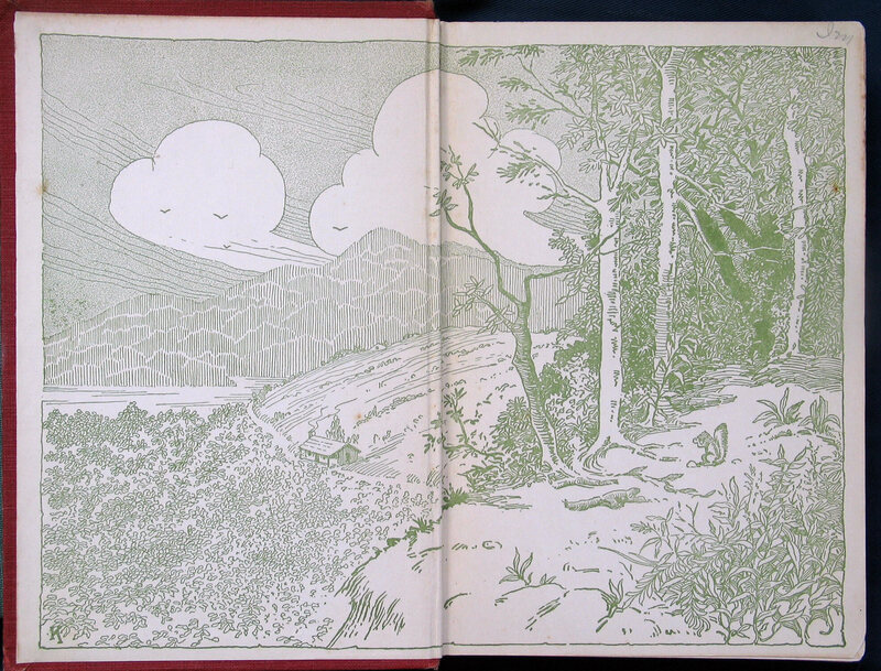
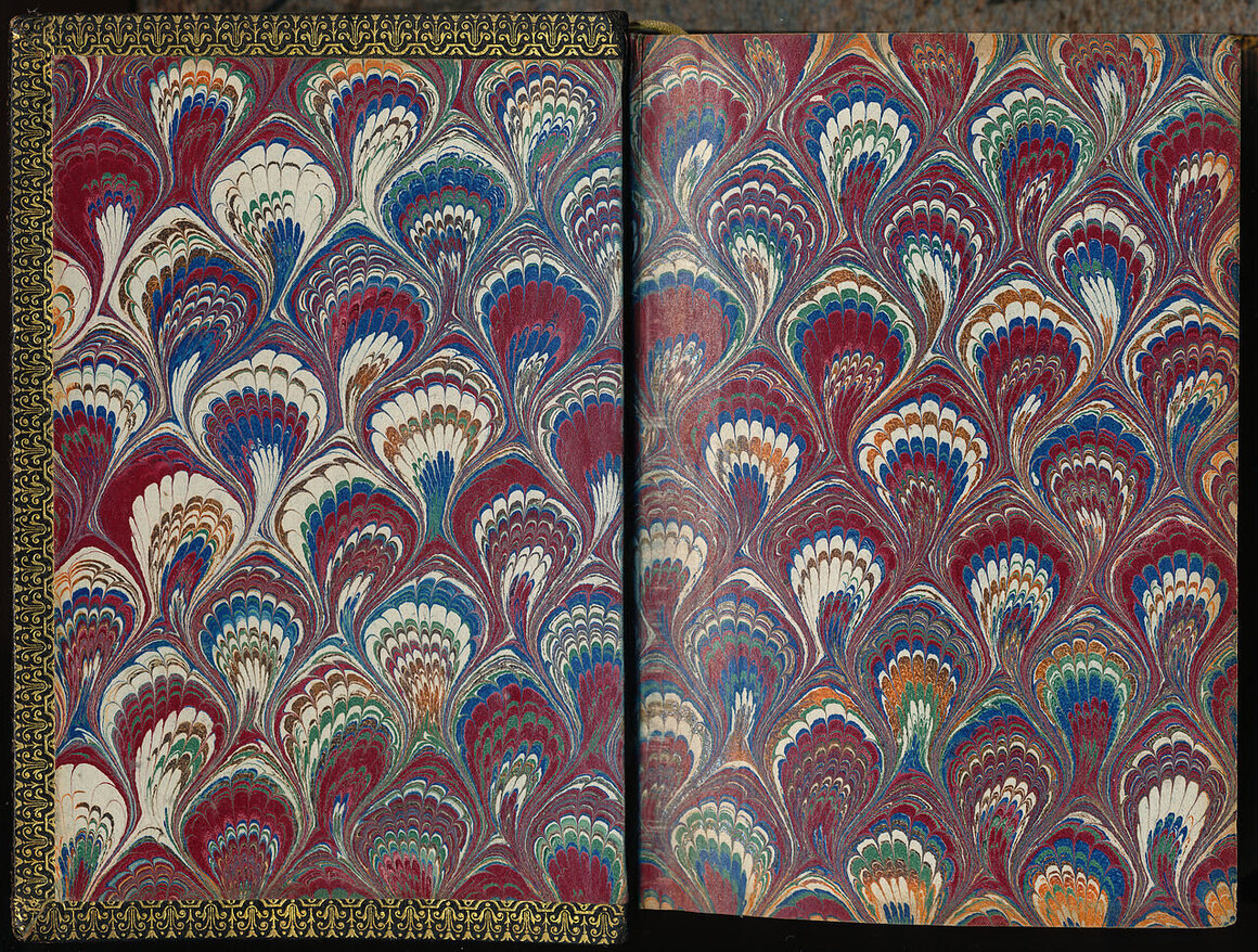
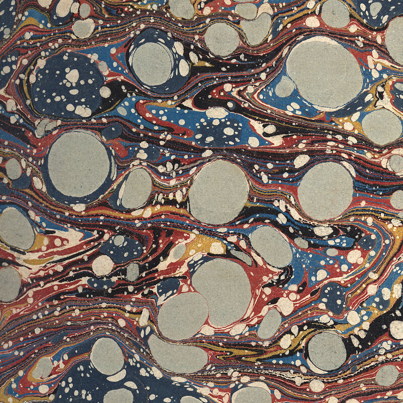
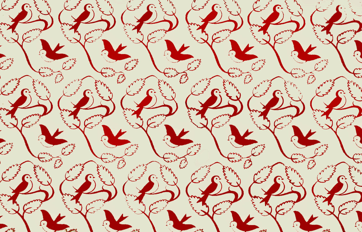
When you open a book, an endpaper is the first secret hiding in between the covers, and a good one can deliver a jolt of wonder. “One of my favourite ways that designers provide surprise is through creative endpapers,” writes Holly Dunn, a book cover designer, “where the viewer opens the book and finds something entirely unexpected and delightful inside the front page.”
Endpapers are often overlooked—an over-eager reader can breeze by even the most striking—but they’re an art form with a history all their own. For centuries, designers have taken the formal necessity of joining a book’s pages to its cover and turned it into an opportunity for creativity. Not every designer is excited about endpapers, but those who are can use it to elevate the beauty of any book.
“I’m always surprised at illustrators who don’t take the opportunity to do some lavish endpaper,” says Bob Staake, an illustrator and the creator of The Art of the End, an as-of-yet unpublished book celebrating the teeming variety of endpapers. “When you find an illustrator who’s respectful of the art form and wants to celebrate its tradition, you see it as something that really stands out.”
When a book is made, one side of an endpaper (sometimes also called an endpage or endleaf) is pasted into the inside of the book’s cover; the other side is the first page of the book. “Endpapers quite literally hold a book together,” says Staake. Originally, they were made of white paper, sometimes scrap leftover from other uses, or of more sturdy vellum, a thin parchment made of animal skin. But in the 18th century, after techniques of marbling had come to Europe from Turkey and Iran, European bookmakers started decorating them with French curls, Dutch combed patterns, classic Turkish stone motifs, and a swirling varieties of other patterns.
When block printing became possible in the 19th century and bookbinding was mechanized in the 1830s, the style of decorative endpapers changed. Now these pages were covered in wallpaper-like, repetitive patterns, “often made from printers’ ornaments,” according to the Salem Athenaeum. Those images developed into softer, more ornate patterns of flowers, ferns, and other natural themes.
It was only toward the end of the 19th century that endpapers started to be illustrated with images that teased at or complemented a book’s subject. Around the early 20th century, children’s books started carrying illustrated endpapers as well, and today they contain some of the most vivid and creative endpaper examples.
Endpaper space might be used to publish a map of the place where a book takes place, whether real or fictive, or it could be used to illustrate a book’s theme. Tucked inside, endpapers can also be bolder than a book’s outside: “They aren’t thrust into the limelight like the cover and spine, and therefore can push the boundaries more,” writes Dunn. Sometimes limited run editions of a book will have hand-painted endpapers; some rare books are snapped up primarily because of their endpapers.
Endpapers can contribute to telling a story even if they’re not illustrated: a red endpaper at the front of a book might communicate the heat of the sun, and a blue endpaper at the back, the cooling rain that ended the drought. And if the endpaper can include an image, the creative possibilities are as varied as books themselves, as this collection shows. Endpapers can be titillating, they can be bright and bold, they can draw you in with a wealth of detail.
When Staake creates endpapers for his own books, he likes to riff on the tradition of repetitive wallpaper patterns, drawing in themes and characters from the books themselves.
“I’m always thinking at about the halfway point, what are the end papers going to be?” he says. “I think they’re very poetic."
“The way we’re exploring this is not much different from how Humboldt or Wallace or Darwin got to these places 200 years ago,” José Padial explained one morning last February, as gauzy light slanted into a forest clearing deep in Peru’s remote Vilcabamba Range. His team had just slashed through a mile of steep jungle with machetes, collecting dozens of specimens—from iridescent lizards to unremarkable brown frogs—many of which appeared to be new to science. Padial had almost trampled on a bushmaster, one of the hemisphere’s most dangerous snakes, and now heard rumors that some members of the local Asháninka community were plotting to block him from leaving their territory with specimens he had government permission to collect. Camped just below 2,000 meters (6,500 feet) in a damp patch of cloud forest, the herpetologist was two weeks into his expedition but still several days from his goal—the isolated grasslands atop one of South America’s least explored mountain ranges. His most reliable source of navigating the team’s route there were some low-resolution images he’d printed from Google Earth.
Not that any trail map—or trail—existed. Few humans had ever set foot on the upper reaches of the Vilcabamba Range, a northeastern spur of the Andes that juts like an archipelago into the sea of Amazon jungle. And fewer still in the half-century since two wealthy New Yorkers, Brooks Baekeland and Peter Gimbel, became the first to do so, dropping by parachute onto a 10,500-foot-high grassy plateau in 1963. Lured by stories of Incan gold, ruins, “Indian taboos” and “sacrificial lakes in the sky,” the explorers instead encountered a primeval landscape of soggy Sphagnum bog, hilly prairie, and stands of pygmy bamboo. With two companions, they spent more than two months bushwhacking down to the Amazon basin, surviving blinding wasp stings and spooked natives with bows drawn. National Geographic’s title of the account suggested a fairytale: “By Parachute into Peru’s Lost World.” Baekeland, the grandson of the inventor of Bakelite plastic, would later recall the pioneering trek “as though in a nightmare.”
“Part of me wonders if we should have parachuted into the upper part of Vilcabamba,” Padial wrote on the expedition’s Tumblr blog before leaving Pittsburgh, where the 39-year-old Spaniard serves as the Carnegie Museum of Natural History’s assistant curator of amphibians and reptiles. He knew that reaching the highlands by foot—during the height of the rainy season—would be a slog. He’d tried before, in 2008, but never made it above 1,800 meters (6,000 feet). Improvising a route through steep, tangled jungle and schlepping tents, tarps, cooking pots, camera gear, solar panels, and food for at least a dozen people between successive base camps required ample trailblazers and porters. Padial expected to have little trouble finding local Asháninka willing to work, and offered more than twice the going wage. Still, he struggled to recruit just six of them. The cold, lofty terrain, the time away from families—most able-bodied workers simply didn’t care for the job description. One porter bruised his knee after a week and went home. Another, a 14-year-old named “John Clever,” shot a kinkajou, a raccoon-like creature one night, and after gutting and smoking the animal until morning, descended with it and never returned.
Scientific exploration in the remotest parts of the world is impossible to script. Every one of Padial’s expeditions has involved some unanticipated mishap, some checked ambition. The previous year, while exploring a rugged swath of Amazonian jungle along Peru’s border with Brazil, his team showed up at an Asháninka community with 20 days’ worth of gear and provisions, and permits from local officials granting access through the territory. The community welcomed them, offered shelter for one night, and then, refused to let them pass. Complications like this come with the territory, however, and for Padial and the other biologists are the cost of achieving the ultimate goal: finding something no human has ever seen. “We all have this draw of early explorers,” he told me. “We want to go to those places where no one has been before, and be the first to find these animals.”
There is scientific importance to such a quest, of course. Each discovery brings new perspective about the planet’s biological diversity, and helps us understand how much we are losing every time we decide to bulldoze or clear-cut an area. “At the least, we leave a record behind of what there was there at a time,” Padial says. Simply knowing what lives where also helps to fill gaps in the tree of life, the genealogical relationships among species. Every undiscovered organism out there, Padial explains, is a missing link in our understanding of evolution as a whole, as species are the entities that actually evolve.
“If you don’t discover these species and give them a name, they pass unnoticed. They don’t exist.”
The Vilcabamba is filled with unnamed species, Padial believes. Biologists have long suspected that its range of elevations and wide variety of habitat types harbor a tremendous diversity of animals and plants. The few scientific expeditions ever to have penetrated its vast, untrammeled wilderness encountered several new species in “unexpected habitats or in surprising abundance,” according to one account. Logging, natural gas and oil exploration, and agriculture now threaten to fracture this pristine picture, and Padial hopes that by shedding light on the region’s richness, this expedition—officially titled the Carnegie Discoverers Expedition to Vilcabamba—might begin to make the case for its protection.
In camp, Padial poured himself a cup of rainwater-brewed coffee, and then gathered his team around an improvised table made of sticks to devise a way forward. Smoke billowed from the cooking fire, nestled against the base of a tree trunk, over which moss-covered logs had been stacked to dry. Padial laid out his Google Earth printouts and a topographic map. The satellite images showed a birds-eye view of the densely forested ridgeline they’d been tracing, the same ridgeline that continued to rise sharply above them to 2,500 meters (8,000 feet), zigzagging for a couple miles, and then sloping gradually toward a hilly prairie at around 3,200 meters (10,500 feet).
It was impossible to tell how long it might take to get there, but they had ten days to try. The team—six biologists (Spanish and Peruvian), a cook (also a Peruvian biologist), and Padial’s girlfriend, a Mexican dancer and filmmaker—was used to the uncertainties and deprivations of expedition life, anyway. Most had joined Padial on previous amphibian and reptile surveys. They hadn’t showered for days, and wore damp underwear and socks. By past standards of luxury, the French-press coffee maker that Padial had secured this time represented something five-star. More importantly, they’d heard the Vilcabamba highlands concealed a herpetological Lost City of the Incas, an irresistible quarry: frogs, toads, lizards, and snakes found nowhere else on Earth.
Padial had been looking for lost places ten years earlier, when he first spotted the 110-mile long mountain range while flying around South America on Google Earth. A rocky massif fringed with green, the Vilcabamba called to mind the tabletop mountains, called tepuis—the inspiration for Arthur Conan Doyle’s The Lost World—that loom above the Venezuelan jungle like islands in the sky and host species found nowhere else on Earth. “It looked high and isolated,” Padial recalls. “I thought, ‘Wow, it would be amazing to go there.’”
The Vilcabamba Range emerges out of the steamy Amazonian lowlands, at an elevation of around 450 meters (1,500 feet), and climbs to a jagged, central crest above 4,200 meters (14,000 feet). The local native groups—the Asháninka, Matsiguenga, Nomatsiguenga, and Yine—never settled the lofty interior, finding it too cold, wet, and lacking good soil and game. It remains largely virgin, free of roads, and enjoying token protection within the boundaries of Otishi National Park and two indigenous reserves. Cut off from the eastern slope of the Andes by the Apurimac and Ene rivers, a main source of the Amazon, and moated by deep valleys and gorges on all sides, its isolation has set the stage for a wide range of endemic flora and fauna to evolve. A frog living at 2,000 meters (6,500 feet) in the Vilcabamba cloud forest would have a long way to hop across several thousand vertical feet, through several foreign habitats, to reach familiar turf across the Apurimac. No chance. “The species that live in the upper area have probably been isolated from the rest of their relatives for a very long time,” Padial explained. Exactly how long these organisms have been isolated is one of the things he and the others aim to figure out.
The mountains are in a rich neighborhood already, ecologically speaking. The tropical Andes is considered one of the world’s 35 biodiversity “hotspots,” boasting the highest percentage of endemic plant and vertebrate species—creatures like the yellow-eared parrot (Ognorhynchus icterotis) and spectacled bear (Tremarctos ornatus). A recent survey of Manu National Park and its buffer zone, along the eastern slope of the Andes in southeastern Peru, counted 287 reptile and amphibian species (as well as more than 1,000 species of birds—around 10 percent of the world’s total) living there alone: the most diversity found in any protected area on the planet.
Lying 100 miles northwest of Manu as the parrot flies, the Vilcabamba Range, in contrast, remains terra incognita. Tough to access, no other area in the Andes of even remotely comparable size is still so poorly known to biologists. It has never been all that welcoming. Throughout the 1980s and '90s, the Ene-Apurimac Valley was the heartland of the Shining Path, the Maoist guerrillas who terrorized Peru. Nowadays, the area is the world’s largest producer of coca, whose leaves are refined into paste at clandestine camps in the forest. Just south of Padial’s route, drug mules by the hundreds cross the Vilcabamba by foot, with medics and armed escorts. Encounters with traffickers can be tragic: Members of a Bolivian scientific team were slain in that country’s Noel Kempff Mercado National Park in 1986 after their aircraft inadvertently landed beside a clandestine coca-paste factory.
The few research efforts undertaken in the Vilcabamba Range over the years have managed to paint a picture of exceptional biodiversity. In the late 1960s, American ornithologists John Terborgh and John Weske mounted a series of landmark expeditions to study bird community structure along an altitudinal gradient from 600 to 3,520 meters (2,000 to 11,500 feet)—basically what Padial hoped to mimic for amphibians and reptiles. They recorded 405 species on the mountains’ western slopes alone. (It’s estimated that the Vilcabamba Range may contain more than half of all bird species known from Peru.) Then, in 1997, Conservation International and Smithsonian Institution surveys found many new species, including a pale grey tree rat the size of a domestic cat. Their report declared the area “a special place in relation to biodiversity.”
Padial’s first expedition there was sort of a misadventure. In 2008, he and his former Ph.D. advisor, Ignacio de la Riva, a biologist from Spain’s National Museum of Natural Sciences, led a team that attempted to reach the highlands by following a river upstream from Kimbiri, a tropical town along the Apurimac. Mapping a distance of five miles, Padial figured they could get there in two days of solid hiking. The terrain, however, proved far steeper, muddier and harder to penetrate than one could glean from a satellite image. After two weeks, exhausted and hungry, they turned back.
Padial knew better this time. He spent two years planning the expedition, securing funds from Carnegie Museum donors and permits from Peruvian government agencies. He’d negotiated delicately with the residents of Marontuari, the Asháninka community at the base of the ridge, gamely sipping their alcoholic homebrew of fermented yucca root from a hollowed gourd as they spoke about the threats to their territory from encroaching coca plantations and a planned hydroelectric dam, as well as their reservations about Padial himself. “They are very suspicious about what we do with the samples,” he says. “To them, it's just weird, the whole idea of conservation—that someone goes and collects these animals that no one pays attention to. If you put money into something, [they figure] you're going to get something.”
Rather than clamber upriver, his plan this time was to drive an hour into the Vilcabamba up a dirt road from Pichari, a sleepy town along the Apurimac, until it dead-ended in Marontuari. Bushwhacking from there to the highlands, his team would pitch successive base camps—where flat ground permitted—as the environment transitioned from lowland montane forest to cloud forest, elfin forest, and finally, the Puna grasslands, a treeless region found across the central Andes between 3,200 and 4,000 meters (10,500 and 13,000 feet).
When Baekeland’s team parachuted there in the 1960s, they glimpsed an Andean spectacled bear and a Peruvian puma, but little else. Three decades later, the biologists working with Conservation International—landing by helicopter—spotted guinea pigs, numerous grass mice, and a large arboreal rodent (family Abrocomidae) that resembled one known only from bones excavated from pre-Columbian burial sites at Machu Picchu, farther south. They collected just four species of reptiles and amphibians—three frogs and one lizard—but all appeared new to science.
For Padial, the promise of scientific discovery is what had lured him to herpetology. As an undergraduate in Spain, studying biology, he volunteered on a couple of field expeditions in the Bolivian jungle and kept finding it a struggle to identify the amphibians and reptiles he observed. Even today, no general field guide yet exists for reptiles and amphibians of the Amazon. While some 7,500 species of amphibians have been identified worldwide, untold thousands remain at large. Since 1985, the total number of recognized species has increased by more than 60 percent—a new species of amphibian is described in the scientific literature every 2.5 days. Yet knowledge of their diversity and distribution pales in comparison to what scientists understand about birds and mammals. “It’s just amazing how much there is to do,” Padial says.
In the past decade, he’s launched several successful, globe-spanning expeditions, including three trips to Mauritania that resulted in the first species accounts of amphibians and reptiles for that country, as well as a pioneering excursion into Peru’s Alto Purús National Park, a wild, poorly known patch of Amazonian rainforest home to several uncontacted nomadic tribes, that yielded several new species.
Putting animals on the map of science can serve a conservation goal, too. The Vilcabamba Range stands as one of the last intact tropical montane forests left in South America, a species-rich belt that once ran the length of the eastern Andes, from northern Venezuela south to Bolivia. Yet along its lower flanks, the elevation holding the most biodiversity, the forest is being destroyed at an alarming rate to make way for coca and coffee plantations. Illegal logging also chips away. Much of the interior is within the bounds of two indigenous reserves and Otishi National Park, but the park’s staff, which includes eight rangers charged with policing 1,100 square miles (an area the size of United States’ Yosemite National Park), have few resources to combat encroachment, not to mention drug traffickers traipsing around with weapons. Perhaps by shedding a light on the unique and extraordinary life in the Vilcabamba, scientific efforts like Padial’s could help Otishi acquire the resources needed for more robust protection, like those afforded to Manu National Park. And maybe somewhere high in “Peru’s Lost World” there lives a charismatic, endemic species of frog yet to be discovered that could become an emblem for conservation.
Throughout the expedition, the scientists often encountered animals by happenstance—a lizard found skittering between campfire logs, a frog startled during a walk to pee. But since many amphibians are nocturnal, the best chance of finding them is to go probing after dark. One evening at Camp 2, as with most nights, Padial and the others strapped on headlamps and set out to collect. He wore rubber boots, square-rimmed glasses, and a collared shirt with pens tucked into the breast pocket. The group fanned out along with trail, walking slowly. They scanned leaves and tree trunks and poked at the wet leaf litter with sticks. Soon, Padial’s light reflected off the eyes of a small brown frog perched haplessly atop a leaf. He snatched the animal up, and holding it under the beam of his headlamp by its legs, gave it a quick taxonomic spot check.
Padial specializes in New World “direct developers” (Terrarana), a sprawling group of frog families ranging from Texas to northern Argentina. Instead of laying eggs in water that hatch into tadpoles, Terrarana frogs deposit their eggs in moist dirt, or moss, out of which emerge fully formed juveniles. Most of the frogs and toads in the Vilcabamba were of this type, as the steep slopes allow for few ponds or standing water.
Padial could tell immediately that the frog belonged to the genus Pristimantis, a large group of mostly terrestrial direct developers. But he was looking for traits that might help place the frog more precisely on the family tree. Did it have an exposed tympanum (ear drum)? Sticky toe pads? Was its belly transparent or pigmented, glandular or smooth? What kind of dot pattern colored the inner thigh for signaling the opposite sex? A few days earlier, Padial had collected a frog that at first glance resembled one he’d collected on a previous trip to the Amazon. But on closer inspection, he noticed its sharper snout and transparent peritoneum, the spider web like membrane covering the organs that on some frogs is pigmented. “Those are like the differences between a chimp and a human, like being fully covered by hair or not,” Padial explained. “I think it was a new species.”
He plopped the Pristimantis into a clear plastic bag along with some leaves to keep the frog moist. Searching for and catching animals was the fun part—Padial had been doing that since he was a kid, hunting snakes near his grandfather’s house on the outskirts of Granada, Spain. Later came the humdrum tasks: measuring frogs, counting scales, and analyzing anatomy, bone structure, mating calls, genes, distribution patterns and climate data. “You need music for that,” Padial confessed. The team’s forest lab amounted to a stick table covered by a rain poncho, surrounded by bags containing frogs, toads and lizards. Each specimen was first euthanized with a dose of Lidocaine, the numbing drug used by dentists, and tagged with a number. With tweezers, the researchers would then extract a tiny sample of thigh tissue for later genetic analysis, and finally inject formalin to fix the animal’s shape.
With data from his two Vilcabamba expeditions, combined with findings from the CI-Smithsonian surveys in the '90s—the herpetological specimens collected then had yet to be fully analyzed—Padial hoped to assemble the best existing catalog of amphibians and reptiles in the Vilcabamba Range.
Although Padial and his team made important discoveries on the way up, in a sense this was all a means to an end. The ultimate goal was to survey the Vilcabamba’s upper reaches, a haven for endemic species. On the third week, an advance team that included Padial, a Asháninka father and son from Marontuari, and Angel Castellano, an Otishi park ranger, managed to hack a way through to 2,760 meters (9,055 feet). Their track wound past twisted branches carpeted with epiphytic mosses, and sprawling tree root systems that required vertical rock-climbing maneuvers. Passing over gaps in the vegetation where losing one’s footing could mean falling off a precipice, it made the well-maintained Pacific Crest Trail look like the Champs-Élysées by comparison.
Along the exposed ridge top, the cloud forest became a bushy elfin forest of tree ferns, bamboo, and reedy grasses. During breaks in the fog, creeping up from the valley, you could make out the jagged crest of the Vilcabamba Range, still some distance above. The change in scenery came with a host of new creatures; species like the cartoonishly bloated cane toad and electric blue poison-dart frog the team collected around Camp 1 were nowhere to be found. “It’s like going from Florida to Oregon—two different worlds,” Padial said of the transition. The biologists stumbled across what is likely an undocumented species of snake with vertical pupils and a black belly, and a tan-colored frog with orange eyes that is completely different from anything they’d found before. “We knew that if we could reach high altitude in this area we would find lots of new stuff,” he says.
Finding new frogs wasn’t like reaching a lost Incan city, admittedly. For the most part, the herpetologists reacted to each of their discoveries with the kind of enthusiasm a beachcomber might greet a curious shell or weird bit of flotsam.
But if there was any trophy Padial wanted from the Vilcabamba—a feather in his cap—it was a species of marsupial frog from the genus Gastrotheca, which carry their brood in dorsal pouches like eggs in a backpack. He knew that no Gastrotheca species from the area had yet been named, but he felt certain one must exist. “I would bet that the one here is probably cool,” he said. Camping in a humid dell a thousand feet below the grasslands, Padial and the others began hearing the unique tak-ta-tak call of a marsupial frog over the drizzle. The call would start and stop at random times, like a taunt.
One night after a meal of quinoa soup and dried meat, Padial went out looking with Giuseppe Gagliardi, a biologist at the Peruvian Amazon Research Institute. Gagliardi, who has lived all his life in Iquitos on the banks of the Amazon River, has a special knack for spotting frogs, and would have taken home first prize on the expedition had there been such a count.
At this higher, colder elevation, frogs and especially lizard populations were a fraction of what they were in the Amazon lowlands, but as the two walked through foliage dripping wet from fog and daily downpours, Padial sensed even lower frog activity than expected, probably due to the moonlight that filtered through the canopy. “We are always concerned about how many times the moon is going to be glowing when we plan the expedition,” he explained.
Gagliardi let out a forceful whistle, which sometimes stimulates frogs to vocalize. Not long after, they homed in on a Gastrotheca calling from high in a tree. Gagliardi took off his backpack and began to shimmy up the tree, breaking off decaying branches and bromeliads as he climbed. Suddenly, the calls stopped. Gagliardi paused and dangled there for a few minutes, but the frog never called again.
A month earlier, when Padial first arrived in Pichari at the start of the expedition, the director of Otishi National Park had introduced him to local military officials, who, in a gesture of goodwill and good public relations, offered to airlift the scientists by helicopter into the remote, central grasslands of the Vilcabamba Range. It was hard to refuse such a gift. But over the course of the expedition, nailing down that ride proved to be a relentless distraction. The general who’d extended the offer was reassigned, the military had other priorities, and the only means of receiving news from Pichari was a cell signal at 8,600 feet in the wilderness. Now, with possibly just two days of bushwhacking ahead of them before reaching the Puna—it was impossible to say for sure just how long it would be—word came that the helicopter was on.
Padial was torn. His team had spent three weeks gradually advancing up the mountain by then, erecting camps and hauling provisions. They’d already made a comprehensive inventory of the reptiles and amphibians living between 900 and 2,900 meters (3,000 and 9,500 feet), which had never been done before. With another thousand feet of thick forest to go, they were poised to break tree line, beyond which they’d face a much clearer path towards the Vilcabamba’s highest elevations. Flying there by helicopter would depend on both the fickle generosity of a local military commander and even more capricious weather. Padial had misgivings about packing everything up and hiking down. It was a gamble.
Still, time was running out, and the path ahead by foot was anything but certain. In a few days, he would lose three members of his team to prior commitments, and after Angel, the park ranger, sliced his leg with a machete, he was down to only two trailblazers. With hot showers and a rotisserie chicken meal beckoning below, Padial decided to wager on the airlift.
A few afternoons later, with clean clothes and high spirits, the team arrived at a walled-off military compound on the outskirts of Pichari. The airspace above the Apurímac valley was sunny and clear, although high in the Vilcabamba the skies appeared ominous.
“Buenissima,” Padial said, taking it all in. “I can't believe it.” Then he corrected himself. “Well, I'll believe it once we put our feet on that marshy grassland.” After posing for a group photo with the smiling regional general, the scientists boarded the Mil Mi-17 helicopter parked on the airfield.
The helicopter rose above Pichari, and banked around the Apurímac, ascending toward the Vilcabamba crest. The Asháninka, Efrain and his son Wilbur, snapped pictures with their cell phones as the helicopter flew over Marontuari and traced the Pichari River, following the ridgeline the team had spent weeks hiking. Beyond that, the virgin interior of the Vilcabamba unfurled below like a green shag rug, creased with steep-walled canyons and punctuated by waterfalls. As the helicopter climbed to nearly 4,000 meters (12,500 feet), it encountered a thick, chalky cloud ceiling that blanketed the upper mountains. The pilot maneuvered to find a visible path through into the highland plateau, where Padial had provided GPS coordinates for a couple of sites that, at least from satellite pictures, appeared suitable for setting up a camp. But the clouds were impenetrable. The helicopter flew in a wide circle to gain altitude: still more clouds. Stymied, the co-pilot signaled to Padial that they would have to abort the flight.
The next morning, and for the rest of that day, it poured in Pichari. With each dreary hour, Padial began to lose hope that the weather would allow another attempt in the helicopter. The military also let it be known that the ride offer had an expiration—24 hours. At daybreak the following morning, with clouds choking the upper slopes of the mountains—a familiar sight nearly every day of the four-week expedition—the team began packing for home.
Padial was crestfallen—they’d come so frustratingly close. He was annoyed at having put all his chips on the military’s shaky promise of a ride. “We lost a week in which we could've ascended,” he said.
Seated over ginger noodle soup that night from a street vendor in Pichari, he tried to cast the whole experience in a happier light. “The good part is that scientifically we found a lot of stuff, some beautiful new samples,” he said. Padial estimated that the expedition had yielded 14 species that are new to science, including an iguanid lizard with a sharp spiny crest, a beautiful green arboreal snake with a large bold black spot on each side of its head, and two species of Terrarana frogs belonging to a poorly known group that lives in leaf litter on the forest floor.
“It could've been a lot worse,” he conceded. “There could have been an accident. Someone could’ve fallen into the river.” Padial admitted to feeling relief after the team passed back through Marontuari without an incident, as he’d heard some unhappy residents were plotting to block his exit in protest.
The 30-minute helicopter flyover—offering a view of Vilcabamba’s rugged interior that few have ever witnessed—only whet Padial’s appetite even further. “I was like, ‘Wow, this is even more astonishing than I thought!’” he said over dinner. “The landscape is so much more impressive than you can see on the maps.”
Padial felt that despite falling short of his goal—a comprehensive inventory of reptiles and amphibians of the Vilcabamba from top to bottom—the expedition had demonstrated, or perhaps confirmed, something important: the Vilcabamba Range is home to many new species and many more awaiting discovery. This knowledge, he hoped, might motivate other researchers to search the area for different kinds of organisms, and over time, raise the profile of Otishi National Park as a place of unique and extraordinary biodiversity—a place worthy of future protection.
Padial’s team managed to walk out of the jungle with a bunch of specimens and tissue samples, as well as audio and video recordings, of very rare species that had never been recorded, photographed, or analyzed genetically before. All of that novel material would eventually be deposited in public collections and made available to anyone. With it, he and other researchers could begin building phylogenetic trees of species from the Vilcabamba Range, inferring when these animals split from relatives, how environmental changes have affected them, and how they got there in the first place.
Padial also believed that his efforts made a case for the value of going out and traipsing through nature in search of novel organisms—for the merit of old-fashioned fieldwork—at a time when our collective attention, and funding for science, has pivoted toward endeavors deemed relevant for technological progress: robotics, gene sequencing, and the like.
“We can tell the scientific community to leave their comfy chairs and do more fieldwork—and provide more funding for it—because we’re far from knowing what’s living out there,” he told me. “If you can still go to a place so close to a paved road and find 10 to 14 new species of frogs and reptiles in a couple of weeks, imagine how much there is still to do.”
And of course Padial continues to heed the call himself. Shortly after returning to Pittsburgh from Peru, in early March, he emailed to say that he’d already managed to secure funding to go back to the Vilcabamba in 2017.
On March 10th, 1804—213 years ago today—the city of St. Louis went through a brief, well-organized identity crisis. The day before, it had been Spanish. In the morning, it was French. And as soon as noon hit, it was American, as it has remained for all the days since.
This multi-part switcheroo, which historians call "Three Flags Day," was the symbolic and bureaucratic culmination of the Louisiana Purchase, in which France sold a massive swath of territory to the United States for pennies on the acre. The deal came as a surprise to the American government, which had only been trying to buy New Orleans. Instead, they got a piece of land that effectively doubled the size of the country and today makes up 15 U.S. states.
The deal was equally surprising to the Spanish, who had ceded the land in question to the French very, very recently—so recently, in fact, that they were still effectively running most of it. The sudden need to play catchup led to a strange 24 hours for St. Louisans.
Three Flags Day was born from a problem of scale. Although the Louisiana Purchase technically went through on April 30, 1803, transferring hundreds of millions of acres of land is no small feat. It took months for the requisite arrangements to be made. Throughout the summer and fall of 1803, Congress signed papers, and money changed hands. That winter, there was an official Americanizing ceremony in New Orleans, which served as the territory's capital.
But because it was winter in the 1800s, the many territory residents north of New Orleans didn't get word of that switch until much later. So in March of 1804, it was decided that there should be another official ceremony, in St. Louis.
But there was a small problem: St. Louis was one of the cities the Spanish hadn't gotten around to giving up. Authorities soon realized that, in order to actualize the territory's new identity, "two treaties must be put into effect at one time," writes historian Walter Barlow Stevens in St. Louis, The Fourth City. First, the land had to be be transferred from Spain to France. Then, it had to be be transferred again, from France to the United States.
Here's how it happened. On March 8, 1804, the Spanish governor of St. Louis, Carlos de Hault de Lassus, posted a notice on the door of the city church notifying the public about the impending switch of nationalities. The next day, two American representatives—army commander Amos Stoddard and explorer Meriwether Lewis—boated across the Mississippi from Illinois and marched up to the governor's mansion, with a band of soldiers in tow.
A small crowd gathered outside. Just before noon, Stoddard and de Lassus signed some papers and turned to the spectators. "By order of the king I am now about to surrender this post and its dependencies," Delassus said. "The flag which has protected you during nearly 36 years will no longer be seen… From the bottom of my heart I wish you all prosperity."
"Slowly the flag of Spain came down and slowly the flag of France went up," writes Stevens. "The cannon boomed the salute. The excited habitants rushed up to the fort to get as near the flag as possible." The original plan had been to keep the French flag up for six hours, but the citizens of St. Louis—many of whom remembered the city's French roots—were so excited that the American contingent agreed to let it fly until the next day at noon. That night, people gathered in the church and sang French songs. "There was little sleep in old St. Louis during the hours the tricolor flew," writes Stevens.
At noon on March 10th, after a scant 24 hours of Frenchness, everyone assembled at the governor's mansion once again. Although Stoddard was an American, it had been decided that he should play the role of France in the exchanges. (France's go-to guy didn't want to make the trip up.) He signed both lines of the relevant papers and addressed the crowd. On his signal, the French flag went down, and the American flag went up.
Someone called for three cheers, but after all this celebrating, people were tired. "The response was not hearty," writes Stevens. But it's this last identity that—at least so far—has stuck.
If you’ve ever wondered how buildings become haunted, here's a data point: construction workers digging the foundation for a new apartment complex in Philadelphia recently uncovered dozens of centuries-old coffins buried on the site.
CBS Philadelphia is reporting that the remains, which date back to the early 1700s, were unearthed beneath a former parking lot. Long before that, the site had served as the First Baptist Church Burial Ground. While the cemetery was supposedly relocated in 1860, it seems, as CBS says, “that someone didn’t do their job.”
Among the dead are men, women, and children, but without headstones, their identities are not immediately apparent. Many of the coffins are falling apart with age, and local historians and archaeologists are ensuring that the remains are given the requisite care and respect. Efforts are underway to identify the deceased, and to figure out if they have any surviving descendants. Once the research is complete, the bodies will be reburied in Mount Moriah Cemetery.
The apartment building that is set to be erected on the site will be 10 stories tall, with 116 units. These will likely feature a number of modern amenities, as well as ghosts.
During the summer, off the coast of Cape Cod, shark experts are looking for great white sharks. They’re conducting a five-year study of the shark population that summers in the area, and, as the Associated Press reports, the number of sharks they’ve found each summer keeps increasing.
In 2014, the researchers documented 80 sharks. The year before, in 2015, they counted 142 sharks, 101 of which were new to them. This past summer, in 2016, the researchers counted 147—a slight increase from the years before. But 89 of the 2016 sharks, more than half of those counted, were new to researchers.
“We are still seeing a good proportion of new individuals,” Greg Skomal, a biologist who works for the state government, told The Boston Globe. “That means the population may be large.”
As the AP notes, these sharks aren’t intending to bother people; they’re after delicious fat seals. But as summer temperatures rise, more people are spending time at the beach and in the water, which is leading to an increase in shark bite incidents around the world.
Southeast Asia has a long history practicing wayang kulit, or shadow puppetry. Dating as early as the 800s, the art, found in Indonesia, Malaysia, Thailand, and Cambodia is considered one of the oldest forms of freestanding puppetry. These intricate, beautiful rod puppets, crafted out of softwood and animal hide, have been used to tell centuries-old tales, Hindu mythology, and Balinese sagas. However, the cultural tradition is at risk of becoming a lost art.
"Maybe in 10 years or five years' time, the acts of shadow play may be no more," says Pak Daim, a tok dalang or master puppeteer, in the video above produced by Today.
To keep wayang kulit alive and capture younger generations, Daim, fellow puppeteers and visual artist Tintoy Chuo created a special, modern puppet show that tells the story of the Star Wars saga, Malaysian style. They used traditional techniques and instruments, but incorporated special effects and sounds. Custom-made puppets of Stormtroopers, C-3PO, R2-D2, Princess Leia, and Darth Vader whisk across the illuminated screen. The puppeteers even crafted a model of an Imperial Star Destroyer.
Traditionally, the practice of wayang kulit is passed down by family members, but today performers can receive professional training at academies throughout Southeast Asia. Puppeteers hope new interpretations and uses of wayang kulit will draw in more audiences, like the thousands of Star Wars fans around the country of Malaysia, Daim says.
Every day we track down a Video Wonder: an audiovisual offering that delights, inspires, and entertains. Have you encountered a video we should feature? Email ella@atlasobscura.com.