You’ve seen it in a hundred films, the unmarked spy van, packed to the gills with screens and equipment, but it’s not often that you see the real thing up close, in real life. But thanks to the wonders of eBay, one lucky bidder was recently able to purchase a fully furnished FBI surveillance from 1989 that looks like it’s straight out of the movies.
The recently closed auction out of North Carolina, listed a vintage Dodge Ram 350 van in great condition, which also just so happened to be a fully-furnished, and totally awesome, surveillance vehicle. From the outside, the brown van doesn’t seem that notable save for a weird tube attached to the roof and the darkly tinted passenger windows. But in the back is an array of still-functioning spy gear, including video screens, recording equipment, a port for a periscope, and, yes, a toilet. There are even secret cameras hidden on the outside of the vehicle.
In a video tour of the van recorded by the sellers, they say the vehicle was used in a FBI stakeouts, and that the van even still had some of the original investigation tapes inside.
The winning bid for the van came in at $18,700 from a private buyer. The new owner's identity is unknown, but we can only hope that they bought the van for some next-level Sneakers cosplay.
There’s something exciting about being at a special geographic spot, like the exact center of a continent or a point along an imaginary line like the equator. Throughout the globe, monuments and signs are installed to define these geographically significant locations. Only surprisingly often, these markers are actually in the wrong spot.
In some cases, the identifying plaque or signpost was simply placed at some convenient close to the actual point. In other cases, these cartographic frauds show just how hard it is to accurately measure the globe. The constant shift and movement of the land, along with administrative changes like labeling new regions or redrawing borders can send calculations tumbling. At the same time, our methods of measurement have evolved through the years, calculating slightly different spots with each technological advancement.
In the 20th century, many geographic center points were determined using the center-of-gravity method: The region was mapped out on a piece of cardboard, which was then cut in the shape of the outline and placed on the head of a pin to see at what point it balances perfectly. With the advent of satellite-aided and computerized mapping systems, more sophisticated methods have emerged to zero in on these centers. The result is an increasingly precise way to chart the globe. But in the process, some previous geographic markers are rendered inaccurate.
Here are 11 geographic monuments that stand tall and proud, but are not at quite the right location.
Back in 1909, legendary Brazilian explorer Cândido Rondon calculated the center of the South American continent—the spot with an equal area of landmass lying to both the north and south, and east and west. He determined it was in the then-remote and sparsely populated region of Cuiabá.
A modest marker and later a tall striking monument marked the spot. Later, after satellite imaging came along, a different location 28 miles away was identified as the true center. But the original obelisk still stands tall.
In the early 1990s the people of Lithuania got very excited when calculations identified a spot outside the capital city, Vilnius, as the dead center of Europe. A big sculpture park dubbed Europos Park was erected at the spot. But French scientists who had proposed the spot for the center in the first place sent news that they accidentally missed the exact target by 8 miles (14 kilometers). The correct center, which is still contested, is now marked with a square and a small museum.
Standing a mere two miles north from the city of Pontianak is a monument constructed to represent the otherwise conceptual equator. The spot was first marked simply with an arrow on a pole in 1928 by a Dutch geographer when he visited Borneo. The first monument, originally consisting of four wooden pillars surrounding the pole, was rebuilt 10 years later and turned into a permanent monument. A globe was added to cap off the work, as well as a guard to keep it safe.
But due to constant global shift, the monument no longer lies on the exact line of the equator. In 2005, the true equatorial line was recorded a short distance south of the monument and, according to GPS readings, the line continues to move south.
In 1936, geographer Luis Tufiño sponsored a 32-foot monument at the equator to commemorate the 200th anniversary of the French Geodesic Mission which charted the division of the hemispheres and measured the shape of the Earth. A larger monument of the same design was built on the site in 1979. The main attraction, however, is the painted line on the pavement that marks Latitude 0° 0’ 0”, where all visitors take a photo straddling both hemispheres.
Sadly, the painted line and the location of the monument are misplaced. The original calculations by Tufiño to establish the equator have been proven incorrect by more accurate modern technology and the actual line runs about 780 feet (240 meters) north of the monument. What's more, the French Geodesic Mission it commemorates did not actually visit this site on its survey expedition.
Stuck halfway between the geographical poles, the equator, the Prime Meridian, and the 180th meridian, the point that is exactly at 45 degrees latitude, 90 degrees longitude is the center of the northern half of the western hemisphere.
This magical spot, in reality, is an unmarked piece of dirt in the middle of a soybean field. The marker commemorating "45 x 90" is some 1,063 feet away from the actual spot, and is a lot more glamorous, where gift coins are given out to visitors indicated you are a member of the 45 x 90 club.
When Hawaii became a U.S. state in 1959, there was a need to reconfigure calculations to find the new center of the entire country. The new spot was pinpointed near Belle Fourche, South Dakota, and marked with a pole driven into the farmland.
This seemed like a somewhat weak way to honor the very middle of the United States, so the city, a little over 20 miles south of the makeshift marker, decided to do it up right. In 2008, they installed a large granite compass rose and dubbed it the “Center of the Nation” monument. There is even a metal disc in the middle that looks like an official geographic marker (though the official spot is to the north) for people to stand on and snap photos.
Scotland has not one, but three geographic centers. This mess is thanks to the use of different methods of calculation that each return different results. One center point is the midway spot between the furthest point in the North Sea and in the Atlantic Ocean. One is the center of just the Scottish mainland, and another includes the outlying islands. The people of the village of Newtonmore celebrate the first with a cross and stone marker at the spot. But the Scots living near the other two contenders would disagree.
Shortly after the U.S. Geological Survey determined in 1931 that a point near Rugby, North Dakota, was the center of North America, the town authorities worked quickly. The calculation put Rugby on the map, and the town seized its chance. It changed the town seal to an outline of North America, with Rugby as a dot on it. Volunteers erected a 15-foot rock obelisk in town, a proud symbol visible to those visiting or driving by.
But Rugby’s status was recently challenged by a few of the 40 residents of Robinson, a town about one hundred miles to the south. According to some calculations, neither town has the bragging rights, which instead go to a point in the town of… Center, in North Dakota.
The geographic center of the contiguous United States is marked at a point about two miles northwest of Lebanon, Kansas. A small stone pyramid designates the spot measured by a survey performed in 1918. A picnic table and cozy chapel are nearby. Couples can be married at the chapel and a Bible and guestbook allow visitors to reflect and mark their attendance to the middle of America.
The problem is, the actual center determined by the 1918 survey is located on a private farm less than a mile away. And in a second plot twist, a new location was later determined in Agra, Kansas, nearly 28 miles away.
The 45th parallel wraps around the globe marking the halfway point between the equator and the North Pole. In the late 1880s, the United States Coast and Geodetic Survey crew were working their way northward trying to mark it, along the coast of Maine to the St. Croix River. Topographers noticed a house in Perry that just happened to fall nearly on top of the 45th parallel, missing it by the tiniest fraction of a degree (only a few tenths of a second).
The cartographers placed a brass pin next to the house to mark the spot where line crosses the main road. A few years later, the citizens of Perry decided to erect a more permanent marker, which still stands today. But the stone actually sits just a bit south of actual 45th, missing it by about 140 feet. But that took much more modern equipment to determine. The early survey crew was awfully close.
When the road over Mule Pass was built in 1913 and 1914, it was done by prison labor. The stubby concrete obelisk that marks the pass was placed here partly to proclaim that fact, as well as memorialize the triumph of pavement over nature.
But for some reason the marker added another claim: that Mule Pass was right on top of the Continental Divide, the invisible line separating the watersheds of the Atlantic and Pacific Oceans. That line, however, lies about 120 miles to the east, along a low rise in New Mexico.
To ordinary folk in the ancient Mediterranean, affording citrus fruits such as citrons and lemons was a bit of a squeeze. They were very rare, very expensive, and, consequently, very, very prized. In fact, those two fruits were the only citrus known to the ancient Romans. It took centuries for their cousins—oranges, limes, the humble pomelo—to make it from their ancestral homeland in Southeast Asia to Western Europe, a new study finds.
Dafna Langgut, an archaeobotanist from Israel’s Tel Aviv University, used ancient texts, art, and artifacts to plot the route and evolution of the ancient citrus trade. Previous studies of fossilised pollen grains and seeds also proved fruitful. Studying these seeds is a challenge, she writes, because “citrus seeds are oily,” and therefore don't preserve well. And, even to an expert, they look a whole lot like other seeds, particularly when mineralized.
At first, the study explains, Romans only had access to citrons. These rough-looking fruits, sometimes known as etrogim, aren’t much good for eating. They’re mostly rind, and what little flesh there is has a weak, dry flavor. But that didn’t dampen the zest for the fruit. The rind is fresh and fragrant, and useful, Theophrastus wrote in his Enquiry Into Plants, “to make the breath sweet.”
“If the ‘apple’ is placed among clothes, it keeps them from being moth-eaten,” he added. And it had one more incredible property: “When one has drunk deadly poison … it upsets the stomach and brings up the poison.”
The citron came to Rome from what is now Israel, Jordan, Lebanon, Cyprus, and southern Syria. It made its way to the western Mediterranean, Langgut found, sometime during the third and second centuries B.C. Early lemon came later: The first remains, found in the Roman Forum, date to right around the time of Jesus Christ.
These two fruits hogged the limelight for centuries. Later citrus fruits had far less appeal, and by then were cash crops rather than luxury items. Sour orange, lime, and pomelo came in the 10th century, and it wasn’t until the 15th century that the sweet orange arrived on European tables. By the time mandarins appeared, in the 19th century, citrus fruits were old hat.
When a fidgeting fourth grader in Miriam Sicherman’s class at Manhattan’s Children’s Workshop School started pulling up junk from under some floorboards, it seemed like a harmless way to pass the time. Little did she or her students know that within a couple of years they’d be putting together a museum exhibit based on over 100 years of discarded history, all excavated from their school's closets.
Currently on display at the City Reliquary in Brooklyn, Closet Archaeology displays a collection of forgotten ephemera that Sicherman’s students have discovered underneath the floors of their East Village school. Their collection of coins, wooden toys, and scraps of old homework started in 2015 with student Bobby Scotto, who was the first to start exploring a little gap in the floor. “I’ve been in that room since 2001, and it never occurred to me to look for that stuff. It was really [the students],” says Sicherman.
Sicherman’s classroom is in P.S. 61, a school building that dates back to 1913. Once a single school, it is now home to three separate schools, including the Children’s Workshop. Sicherman’s classroom closet, original to the building, once had sliding doors, but when they were removed for whatever reason, it left a gap in the floor where the runner used to be. The gap opens into a hollow space that's acted as a perfect trap for all sorts of tiny items. “We assume a lot of things, like candy wrappers, were shoved in there to not get in trouble,” says Sicherman.
In the beginning, as students would find little trinkets and artifacts, she would let the students take them home, not thinking much of it, but as more and more interesting things were unearthed including old pins, wooden puzzle pieces, and snuff tins, Sicherman realized they were on to something.
After fishing out what he could from the surface of the gap, Scotto began going deeper, using pencils and wire hangers to reach farther back. As he pulled out more and more items, the whole class got interested in digging under the closet floor. The students quickly caught archaeology fever, says Sicherman, and they ultimately worked together to create a catalogue and preservation system for their finds.
As the project grew, Sicherman asked some of the kids to bring back some of the items they’d brought home earlier. This didn’t sit well with all of the young explorers, who had come to hold a sense of ownership over their finds. “They were really mad, and they never quite got over it,” says Sicherman. “I started calling it archaeology right from the beginning, and I decided to try and find a professional archaeologist who could come talk to the kids about it.” It was only after an archaeologist from Columbia University came to speak to the class, and treated them like real researchers, that Sicherman says the kids felt better about relinquishing their treasure.
Scotto and his classmates continued to dig even after they'd advanced out of Sicherman’s class, returning when they could to keep looking under the floorboards. Later classes also helped to continue the project. Through a small grant and donations, Sicherman was able to secure some basic archival supplies to better preserve their finds. She also put some of the more remarkable items on display in a case in the school’s library.
Eventually, Sicherman and the kids got permission to lift some of the loose boards. They also found that other classrooms in the building had the same gap in their closets. According to Sicherman, to date students have managed to work their way through 10 closets.
P.S. 61 has always been home to a school, and many of the most interesting items that Sicherman’s students have found clearly belonged to kids. Old coins, penny candy wrappers, and pencils are common. Much of the paper ephemera has been chewed up and destroyed by mice, but some finds are pristine. “Some paper I guess the mice don’t like, because some paper items are totally intact, including this envelope, which still had two dollars in it,” says Sicherman. Still other items recall other parts of the building’s history, such as 10-cent movie tickets that date back to when there was a cinema next door, and even older items that point to P.S. 61’s role as a draft center during both World Wars. “That did mean that there were lots of young men in the building at times,” says Sicherman. “Which may account for some of the tobacco and alcohol-related items that we have.”
Sicherman’s most recent class even managed to track down a handful of the original owners of some of the items, some of whom were able to come back and visit the class.
And there's still likely much more to find in the school. “A lot of people are baffled by the whole thing, like how could there be so much stuff,” says Sicherman. “That surprised me too until I sat down and did the math and realized that the building is 100 years old, the school year is ten months out of the year. You drop a couple of things down there a month, and over 100 years, you’re going to have a couple thousand items.”
Sicherman says she'd like to continue excavating the rest of P.S. 61 as much as possible. She's been in contact with one of the other schools in the building and would like to try and work out a way to search their closets as well.
It could take years of coordination and planning to search the entire building. Which might not be a bad thing if it means more and more kids will get to take part in this unique opportunity for urban archaeology. “It sounds very trite, but [the students] have developed this sense of wonder that anywhere in the world, in the most ordinary place, there can be something fascinating, and it’s worth checking things out.”
By now, it's been well established that the other planets in our solar system are very weird places. Now it's our closest neighbor's turn to let its freak flag fly. A day on Venus lasts roughly 243 Earth days, with two sunrises—longer than its 225 Earth-day year. Strangely, Venus's atmosphere rotates 60 times faster than the planet itself, and that atmosphere is made up of about 97 percent carbon dioxide (compared with only 0.03 percent on Earth), which helps the surface reach a whopping 864 degrees Fahrenheit. New research points to another weird feature of Venus's atmosphere: waves in the clouds that move at different speeds, under the influence of the topography underneath.
A research team from Europe and Japan used data collected by the Venus Express satellite, and found some interesting patterns in the nighttime clouds, which are little-studied compared to the daytime ones. They observed large areas of waves, bright filament-like clouds, and even stationary waves, all different from the daytime cloud patterns. The fast-moving filaments are rare, and the stationary waves much more common. The researchers suggest that these stationary waves are driven by changes in surface topography, such as mountains, the way water in a creek flows over a rock.
This first in-depth data on the night-side clouds will help scientists refine models the Venusian atmosphere and understand why it moves so fast. The Venus Express mission ended in 2014, but the Akatsuki satellite, launched by Japan's Aerospace Exploration Agency in 2010, is collecting more data, which are sure to present even more atmospheric oddities.
“That’s what they’re doing. Getting on deck and having their pictures taken,” says Val Poore, a teacher and writer from Great Britain, pointing towards the boat moored next to hers. A tourist on deck is posing for a photo, blissfully unaware that she’s standing on someone’s roof. But the signs of life can’t be missed if you look close enough: bicycles, laundry hanging out to dry.
Even the most distracted tourist should notice the sign saying, in the typically direct way of the Dutch: “Private. No entry unless invited.” Because these boats, despite their tourist appeal, are not just barges. They’re home to a vibrant, freedom-loving community that remains hidden in the open in Rotterdam’s Oude Haven or Old Harbor.
Tourism in Rotterdam is concentrated on the water—and many visitors want to see the Old Harbor’s beautiful historic barges.
“There is a lack of awareness that there is a community of people actually living on the barges,” says Poore. She finds people coming on board without invitation quite amusing, and most of the community members regard it with a reasonable amount of goodwill.
Before moving to the Netherlands, Poore lived in South Africa for many years before buying her own 120-year-old barge, De Vereeiniging, in 2001.
“I’ve always needed to live close to the water,” she says. “Being on the boat is just ideal for me. Because it’s all around me all the time, and it’s very restful.”
What really attracts people like Valerie Poore to the barge life is the idea of self-reliance and freedom. “It’s as much freedom as you can have in an organized society,” Poore says. The barge-dwellers in the Oude Haven are not just proud of their boats; they also care deeply about the idea of restoring and preserving the Dutch waterways’ heritage. But maintaining the historic appeal of the Oude Haven is not just something the inhabitants love to do. It’s one of the requirements of living there.
“The exterior has to look like it did when it was a working barge,” says Poore. “And so you can’t just put windows on the side because you feel like it.” As the Oude Haven is a part of the Maritime Museum, the barge needs to come from a certain period in time, preferably before World War II. Boats newer than that look too modern and are too big. De Oude Haven is tiny, hosting around 30 boats. And the sense of community is strong.
“I think the relationships between the people are actually very good because we all have the same purpose. And we all have essentially the same interests,” says Poore, referring to the idea of restoration, heritage and a love of water.
Poore doesn’t tell people that she lives on a boat. ”It is a sort of double life but I’m not particularly conscious of that because my work life and my home life are my normality. I don’t really think of sort of switching into another role when I go home, I’m just myself with whatever I do,” she says. When the topic does come up, she shares where she lives, and people usually show interest in her home on the water.
“The most common question I get: “Isn’t it cold in the winter?” And the answer is, yes it is, but we have heating like you have in the house,” she says. It can also get loud due to the nearby bars and restaurants in the Oude Haven. “At night time and in the summer the harbor is a very noisy place and there’s a very high nuisance factor with noise and the shouting and the loud music, and sometimes fights break out.”
Another thing that brings the community together is the love of what Poore calls “faring,” from the Dutch word “varen,” or to sail. “Look what you can do with a barge. You can cruise on canals and rivers, and you can live on it too and if you want to move you can take your house with you,” she says.
Barges have no sails, but they still move on the water, and can go pretty much anywhere on the canals that can be found all over the Netherlands. “It’s a feeling of being cut off from all the stresses and strains of the normal world,” says Poore. “You distance yourself from politics, from friction, from conflicts, you can more or less forget that the real world exists.”
New regulations, however, have restricted people’s movements. For example, barge-owners with boats that measure longer than 20 meters (66 feet) must have them inspected regularly. For historic barges, it can be hard to comply with the new regulations. The high price of diesel gas also plays a role.
“Fewer people go faring now than used to, partly because of the regulations and partly because they’ve got other commitments now,” says Poore.
And more changers are underway. On May 1, 2017, the Maritime Museum handed over the keys to the slipway yard to the City Council, which could negatively affect the community.
“The slipway and all the workshops there are very much at the heart of the community, and you go there and you chat with other people and you have coffee with other people. So if that is closed down completely, it’s going to make a big difference, there will be no central points for having get-togethers,” says Poore.
The slipway, which Poore calls the helling, is the place where barge owners take their boats for a thorough inspection, which involves pulling the barge out of the water. Poore has booked a week on the helling for October, but with the new situation she isn’t sure she will be able to use it. The slipway is still open for now, but “on the yard and the yard and the workshops, everything is closed. We’re very sad about it,” says Poore.
If the slipway in the Old Harbor is closed, the barge owners will have to go somewhere else for inspections, but some of these places are far away. “If it’s commercially viable they’ll keep the helling open,” says Poore, “but if not, no one knows what’s going to happen.”
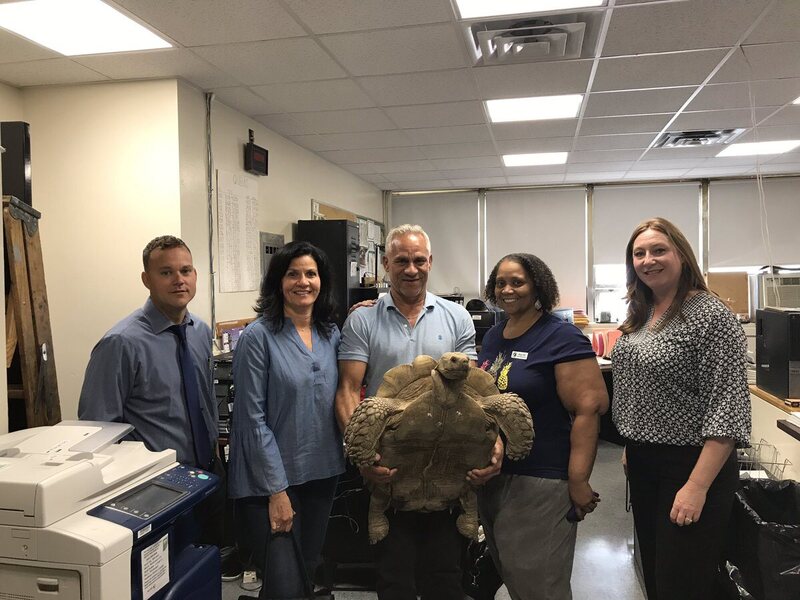
Some time between July 15 and July 16, a 17-year-old tortoise named Millennium disappeared from the Alley Pond Environmental Center in Queens, New York. The 100-pound African spurred tortoise was chelonian-napped—and it was more than a prank.
"I would definitely think it would probably be more than one person to do that, they would have to have something to carry him," an official told DNAinfo then. "You can't walk down the street with a 100-pound tortoise."
On Tuesday, police announced a break in the case: Millennium had been found, safe and alive, and returned to his caretakers at the environmental center.
After his theft, Millennium ended up in Connecticut, where he was traded, for another tortoise, to someone who realized that he was stolen and notified police. No arrests have been made in the case, though an investigation is ongoing, according to CBS2. Millennium, meanwhile, seems happy to be back home, or at least as happy as a tortoise can look.
Neuroskeptic is pseudonymous blogger for Discover who is a neuroscientist in the United Kingdom. He or she resists being named because it might harm the ability to speak freely about issues within the neuroscience community, and also to protect personal relationships with other scientists.
The secret identity also helps Neuroskeptic pull off stunts like the one the blogger announced early Saturday morning, in which, according to the blog, three "so-called scientific journals" were persuaded to publish a "Star Wars–themed spoof paper" written by "Dr. Lucas McGeorge" and "Dr. Annette Kin."
Neuroskeptic was attempting to expose—successfully, in most of the cases—the lack of rigor among what are known as "predatory journals," the hundreds, if not thousands, of open-access journals that exist online primarily to inflate academic resumes, charge for the "privilege" of being published, or some weird combination of both.
The blogger-scientist submitted a paper that was "an absurd mess of factual errors, plagiarism and movie quotes," to nine such journals. Five either rejected the piece or asked for revisions, four accepted the paper. Three of them actually published it. Wrote Neuroskeptic:
So what did they publish? A travesty, which they should have rejected within about five minutes—or two minutes if the reviewer was familiar with Star Wars. Some highlights:
“Beyond supplying cellular energy, midichloria perform functions such as Force sensitivity … ”
“Involved in ATP production is the citric acid cycle, also referred to as the Kyloren cycle after its discoverer”
“Midi-chlorians are microscopic life-forms that reside in all living cells – without the midi-chlorians, life couldn’t exist, and we’d have no knowledge of the force. Midichlorial disorders often erupt as brain diseases, such as autism.”
As Neuroskeptic points out, the only value of academic publishing is in peer review, which, if this list is even a little accurate, is missing from a lot more than nine official-sounding journals.
"Ironically," Neuroskeptic wrote Saturday, "I’m not even a big Star Wars fan."
Many art thieves are out for profit, but the master thief discovered in Avignon this month by French police never sold what he stole. Instead, he gathered it all in his house, until the place was so full that police compared it to Ali Baba’s cave of stolen treasure, Le Parisien reports.
When French police raided the man’s house, they were after just a few paintings. The alleged thief had returned to a hotel he’d already stolen from once, where he was recognized by the receptionist. Inside, though, the police found more than 500 works of art—painting, bronzes, manuscripts, rare books, sculptures, even vinyl records. Some of the collection was carefully labeled with the date and location of the theft; sometimes the thief even added the value of the work.
He mostly operated in the area around Avignon, where he made his home. His thefts occurred over the course of close to two decades, the police said; he would wear a long coat and a hat when he stole. The alleged thief says he suffers from kleptomania: He cannot resist the urge to steal.
Now, police are trying to undo his years of work. They've published an online catalogue of the stolen items, in hopes that the owners will be able to find and reclaim their art.
Remember in elementary school, when you made a baking soda and vinegar volcano on the floor of your family's kitchen, and you piled the papier-mâché higher and higher, and you said to yourself, "This is going to be the biggest one ever?"
The volcano, which was built to go along with the Pompeii exhibit currently on view, started life as a skein of scaffolding outside the museum. Over the course of a short while, its builders added a garbage bag-type surface, and the volcano—now appropriately brown and lumpy, and about twice as tall as your average giraffe—waited for its time to shine.
On Sunday, that time came. As about 3000 cheering spectators counted down, museum employees poured 66 gallons of vinegar, 50 gallons of baking soda and water, and some quantity of red food dye into repositories inside the volcano. Soon after, two spurts of pink fizzy "lava" began spitting out of the top, and everyone cheered wildly, except for a few cranks on Reddit.
The record-related paper work is being prepared, and will soon be sent to Guinness for verification. But one thing is for sure: they outdid you.
Every day, we track down a fleeting wonder—something amazing that’s only happening right now. Have a tip for us? Tell us about it! Send your temporary miracles to cara@atlasobscura.com.
Black Americans have served in the military in every major war since the inception of the United States. But only in June 1941 did President Franklin D. Roosevelt make the first, tentative step toward ending desegregation in the armed forces. He did not, of course, do so out of kindness: a year earlier, labor activist A. Philip Randolph had proposed a march on Washington to protest discrimination in the military. Roosevelt signed the Fair Employment Act to stop the march.
Though his executive order ended discrimination in defense industries, no such change was made in the armed forces, infuriating many black leaders. As the United States edged toward entry into World War II, the black newspaper the Pittsburgh Courier announced in February 1942 its “Double V Campaign,” which called for a double victory against discrimination at home and abroad. Black Americans, as they had for centuries, would fight for a country that marginalized them—meanwhile, they would continue their quest for equal rights.
The Courier declared:
We, as colored Americans are determined to protect our country, our form of government and the freedoms which we cherish for ourselves and the rest of the world, therefore we have adopted the Double ‘V’ war cry—victory over our enemies at home and victory over our enemies on the battlefields abroad. Thus in our fight for freedom we wage a two-pronged attack against our enslavers at home and those abroad who will enslave us. WE HAVE A STAKE IN THIS FIGHT...WE ARE AMERICANS, TOO!
The campaign swept black America, and many black Americans—especially black women—created Double V baseball games, beauty pageants, songs, and hairstyles in protest. As the U.S. entered the war, they joined Randolph in demanding fair treatment under the law.
In 1947, Randolph used this energy to form the Committee Against Jim Crow in Military Service—a.k.a. the League for Non-Violent Civil Disobedience—which demanded that the federal government end segregation in the military. The pressure worked: Harry Truman, who became president in 1945, faced a difficult election and, as Randolph knew, he needed black support.
On this day—July 26—in 1948, Truman signed Executive Order 9981 to end racial segregation in the armed services.
The order announced: “there shall be equality of treatment and opportunity for all persons in the armed services without regard to race, color, religion or national origin.” In 2011, sexual orientation was added to that list. Beginning in 2016, so was gender identity—though a ban on transgender people in the military now looks set to return.
Northeastern Nevada may be dry and covered in sagebrush today, but 252 million years ago it was under a shallow equatorial sea beside the supercontinent of Pangea. It was also home to one of the top predators of the early Triassic, a large-mouthed fish known as Birgeria americana. Part of a B. americana skull was recently discovered in Elko County, Nevada, by a team of Swiss and American paleontologists. Such a well-preserved Triassic vertebrate fossil is a rare find in the United States.
The mass extinction that marked the end of the Permian and the beginning of the Triassic was the largest extinction event in the history of our planet—about 90 percent of Earth's species disappeared, including up to 95 percent of marine species. Unlike the mass extinction that did in the dinosaurs, the Permian-Triassic extinction wasn't caused by an asteroid, but rather acid rain created by volcanic gases. Just one million years after those destructive downpours, the six-foot-long B. americana was the undisputed king of the local food chain.
This trophic dominance is surprising, because until now, scientists thought predators like B. americana didn't show up until about five million years later. But it's no wonder it was the top fish. Scientists believe it hunted by chasing down and biting its meals with three rows of sharp teeth—the great white shark of its time.
When Ann Kerrigan found an old class ring in her Lebanon, New Hampshire, backyard, it was as though it had just been planted there. “It was just there,” she told necn. “It was so strange. It’s not like I was digging.”
The discovery sparked a detective-style investigation to identify its original owner, who, according to the ring, had graduated from Lebanon High School in 1965. Kerrigan called the school to describe the gold-colored ring and provide a crucial clue: the initials inscribed on it. They were looking for an "RG."
The school-office probe picked up steam. Secretary Amanda Clarke and tutor Lauren Anikis leafed through yearbooks, scoured Facebook, and even paid for a temporary subscription to Whitepages.com. “We just thought how nice would it be to get a piece of his past back,” Clarke told Valley News.
At last, a breakthrough. They identified one Raymond Goodwin, who now resides just across the state line, in Hartford, Vermont. Goodwin, a retired cook, said he had lost the ring sometime in the brief period between the end of school and graduation—down a drain, he guessed. “My mother and father really gave me grief when I lost that, God rest their souls,” he said.
Goodwin met with Kerrigan and the team of detectives at the school, where they handed over the ring and shared Kerrigan’s own story of a missing class ring. Decades earlier, she’d lost her 1981 Chestnut Hill College ring. Five years later, a stranger returned it to her.
But one enigma still eludes the Lebanon High School office detective squad: What mysterious force brought the ring the three miles, from Goodwin’s childhood home to Kerrigan’s yard?
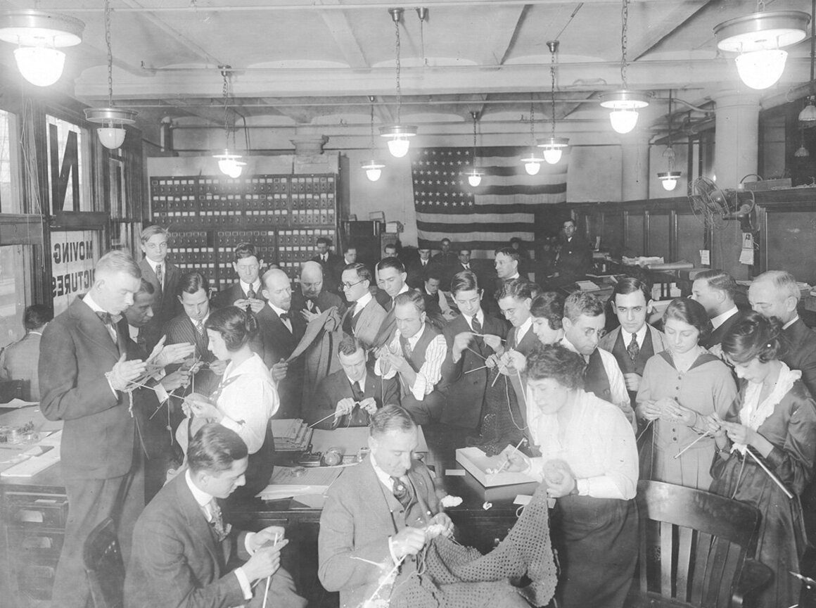
In August 1918, the Comforts Committee of the Navy League of the United States opened a three-day knitting bee in Central Park. It was a massive event, with a sole purpose: to produce warm garments for those fighting in World War I. At the event, there were knitting competitions for speed and agility, and attendees ranged from children to octogenarians. The numbers were so great that one of the chairwomen said, “the click of the needles could be heard all the way to Berlin.” By the end of the “knit-in,” the Comforts Committee had raised $4,000 (roughly $70,000 today) and created 50 sweaters, nearly as many mufflers, 224 pairs of socks, and 40 head-and-neck coverings called "wool helmets."
During the war, there was an overwhelming effort to assist those fighting abroad. Before America even joined the war, organizations such as the American Red Cross and the American Fund for the French Wounded had issued pleas for warm clothing for soldiers—or, as a Navy League poster put it, to “Knit a Bit.” After April 1917, the Red Cross and the Comforts Committee worked together to mobilize ever larger numbers of knitters, with a request for 1.5 million knitted garments. (There was also another way to use knitting against the enemy—spycraft.)
The need for warm clothes, particularly socks, was desperate. Men at the front were fighting in the atrocious conditions—muddy trenches and frigid winters—with inadequate footwear. “The difficulty is to keep one’s feet warm,” wrote one officer in 1917. “One walks and they get warm, stand for one minute and they are icicles again.” Soldiers also needed to keep their feet warm and dry to avoid frostbite and trench foot, and the best way to do this was to don clean socks regularly.
Knitting was promoted as a patriotic duty. A Red Cross poster showed a woman knitting diligently, with the words, “You Can Help.” Tape measures were sold in red, white, and blue, and the Betsy Ross Yarn Mills advertised their water-repellent, khaki and grey wool with “Uncle Sam Wants You To Knit To Protect His Boys—‘Over There.’” The Allies Special Aid knitting bag exhorted the efforts of the homefront knitters in military terms:
Do you belong to the wool brigade? If not, then come along. Mothers, wives and maidens Make this Army strong.
Gray Wool is our ammunition; Some make it into balls Pass them to the knitting squad; They will soon use them all.
For this is no time to be idle And sit with folded hands Pick up your knitting whenever you’re sitting. A sock soon grows under your hand.
Hark! I hear the bugle call. Somebody wants another ball.
To assist these knitters, booklets of knitting patterns were issued. The Khaki Knitting Book, published by the Allies Special Aid organization in 1917, took the effort particularly seriously, with the following warning from the editor: “The money from the sale of the Khaki Knitting Book goes to the Allies and anyone lending the book to a friend who can afford to buy one, defrauds the Allies.”
People knitted not just at home but at work, at church, on public transport, in the theater, and while waiting for trains and sitting in restaurants. Female lifeguards in Southern California, covering for men who had gone to war, brought their knitting to the beach. A sitting grand jury in Seattle knitted socks. In 1915, the New York Philharmonic Society had to issue a plea for audience members to refrain from knitting, as it disrupted performances.
Men who had not gone to fight also contributed. There are accounts of Red Cross members teaching firemen to knit, train conductors knitting between stations, and inmates at Sing Sing knitting in the prison yard. Men were encouraged to knit at work during their lunch hours, and wounded soldiers knitted from their hospital beds.
The practice of knitting was so widespread that it became the subject of parody. In 1918, the New York Tribune ran a series of illustrations on the different types of knitters, including “Miss Tupper, who spends so much time watching to see if her neighbors are knitting … that she never gets very far along with her muffler.” Enthusiasm for knitting didn’t always translate to skill either. There is an account of the following verse from a soldier:
Life of a pair of socks They are some fit! I used one for a helmet And the other for a mitt Glad to hear You’re doing your bit – But who the ___ Said you could knit?!
The success of these homefront efforts is reflected in the staggering growth of the Red Cross at the time. Between 1914 and 1918, membership increased from 17,000 to more than 20 million. Its reach extended across the country, and included an estimated 35,000 Native American adults and children who also knitted for the war effort. In total, the Red Cross estimates that 370 million knit items were produced between 1917 and 1919. Today, knitting is still an active part of the Red Cross support for veterans.
Atlas Obscura has gathered a selection of photographs of the Wool Brigades of WWI.
The small village near Trinity Bay, Newfoundland, was once a charming place to live. A quaint, centuries-old fishing village, that overlooked the sea, with winding lanes, asymmetrical “saltbox” family homes, and quiet streets filled with a post office, church, and a graveyard. It would be an idyllic, country scene, apart from the fact there are no people.
The Canadian province of Newfoundland and Labrador is home to around 300 such ghost villages.
Between 1954 and 1975, around 30,000 people were relocated as part of controversial government “resettlement” programs. Today these abandoned villages are largely forgotten and unknown, except by those who once lived there.
Newfoundland and Labrador is a vast, beautiful, often remote and isolated place. The wild landscape is home to unusually named towns such as Come By Chance, Heart’s Desire, Happy Adventure and Chimney Tickle. Dotted sparingly along its miles of rugged shorelines, and in the shelter of its thousands of tiny islands, are the “outports”; small, tightly knit fishing villages, many dating as far back as the Revolutionary and Napoleonic Wars.
By the end of World War II, the population of Newfoundland stood at around 320,000, spread out over a thousand such settlements, three quarters of which held under 300 inhabitants. Some villages, such as Tacks Beach on King Island, had a population of several hundred, while others such as Pinchard’s Island, Bonavista Bay, had just eight families living there.
These communities were largely self-sufficient, and mostly isolated from each other. They lived by fishing the abundant cod and herring fields, and by logging and seal hunting.
But life in the outports was to change forever in 1949. That was the year Newfoundland and Labrador, Great Britain’s first permanent colony, voted to join Canada. Following confederation, the government began to take a keen interest in these hundreds of isolated communities. Pondering what to do with their vast new territory, with its rich fishing fields, it commissioned studies undertaken by the Department of Welfare and the Department of Fisheries.
Anthropologists dispatched from Memorial University in St. John’s—the capital of Newfoundland—found that in Placentia Bay, located in the southwest, only 68 percent of children could read and write. Medical care was sparse. Some small communities, such as Come By Chance, had a cottage hospital, but they were few and far between. Some of the more remote outports were served by occasional medical ships such as the M.V. Lady Anderson, which ferried doctors around on 40-foot boats. One fisherman interviewed on King Island explained that “if the wife got sick … it’s two hours away [by sail] and if it was rough, you mightn’t get there at all.”
Experts landing at Little Brehat, a bay in northern Newfoundland found a fishing village of 14 families, with “no road connection, no agricultural potential” that was “often completely isolated in winter.”
The Canadian government concluded that a significant part of the Newfoundland population was living in conditions not far off the 19th century. But many people living in the islands were reluctant to leave the only home they’d ever known. The Government Game, a protest song about resettlement written by poet Al Pittman in 1983, includes this verse:
My home was St Kyran's, a heavenly place, It thrived on the fishin' of a good hearty race; But now it will never again be the same, Since they made it a pawn in the government game.
And the costs to modernize the new province, to provide electricity, telephones, medical care, and education at a level that would match the rest of Canada, would be enormous given the distances involved. Over on Sop’s Island, population 222 in 1956, the government inspectors recorded that because “there are no roads and because of the rugged and mountainous country, the cost of building roads … would be tremendous.”
For the Department Of Fisheries, the primary concern was how best to capitalize on the rich fishing industry of its new province. Small fishing villages were to make way for deep-water ports capable of berthing deep sea trawlers, bringing their catches back to modern, mass processing plants. “Formally one case of the resettlement may be based on the economic non-viability of the Newfoundland fishing ports,” concluded a report by the Canadian Council on Rural Development, which was ominously titled “Economically Worthless.”
The only solution, it seemed, was to make the distances between these increasingly isolated villages smaller; their inhabitants would have to move to larger “Growth Centres.” Asked one government official: “Could the settlers upon these barren little islands and the rugged creeks and coves which present no basis for growth and prosperity, be induced to remove en masse?”
The government report on Sop’s Island concluded: “In my opinion, the settlement should be completely evacuated.”
The first inklings of the change came in 1957, when a government questionnaire was sent to “doctors, clergy and other responsible persons” living in these peaceable villages. The questionnaire was to gather their “opinions as to those settlements suffering from social and economic problems and which might be vacated.” And so the doctors and vicars began surreptitiously weighing up the future of the outports and whether centuries of tradition were to be suddenly abandoned.
One such village was Tacks Beach, a small community on King Island, whose natural inlet provided a perfect harbor for the fishermen who lived there. By 1961, Tacks Beach had a population of 153 registered voters, one of whom, Howard C. Brown, would write a case study of the abandonment of his childhood home in St. John’s, a decade later. He described a picturesque island community that “had a large Anglican church, a four-room school, an Orange Hall (a fraternal organization), a Post Office, and a large general store” run by his family. Tacks Beach was connected to the outside world with a telegraph office, and a weekly supply boat, chartered by the government.
But Tacks Beach would not survive the government inspectors, who were alarmed at the education levels in the village, noting that “in late August of 1966 no one knew if there would be a teacher … for the coming school year.” The boom was soon to be lowered.
At first the proposed resettlements were to be decided on by the outports themselves. A petition and vote was held, with a majority of 80 percent needed for the village to be abandoned. These petitions saw the villagers at each other’s throats. Often the divisions fell according to age, with the younger families keen to move because of education. “It is so much better for the children,” wrote one Tacks Beacher. “The younger ones will get better education than the two eldest.” Others, often with their loved ones buried in local cemeteries, were desperate not to give up their trusted way of life, their family homes and their heritage.
To sweeten the resettlements, financial incentives were offered by the government. The sums started at $400 per family in the 1950s (at a time when the annual average salary for a fisherman was around $500) and rose to $1,000 per household by the next phase, with an extra $200 for each dependent.
But where some outports held out, clinging to their old way of life, unofficial coercion saw the vital post offices threatened with closure. One by one, the old outports were steadily vacated.
The resettlement saw the surreal sight of many cottages being moved in one piece, so-called “sturdy homes,” dragged by the villagers over ice, or floated across the water to their new homes, buoyed by oil drums. The homes that couldn’t be moved in one piece were simply left.
On Flat Island, 500 people crammed into St. Nicholas’ Church for one final service before being split up and relocated to the urban growth centers.
Over on Tacks Beach, most people moved at Christmas, 1966. One villager recorded a poignant handwritten account of the last days of the island, which is now held in the archives of The Rooms Museum, St. John’s, they noted down that one Garfield Brown had the first house to be taken away, and that the last person to leave the island was Arthur Comby, aged nine. They recorded that the last couple to be married were George Brow and Bertha Perry, on December 29, 1965. Seven families stayed at Tacks Beach for a final Christmas holiday in their homes, but by the autumn of 1967, the entire island was abandoned.
Scott Osmond, who runs the Hidden Newfoundland website, and who has explored many of the abandoned outports, says “the Newfoundland resettlement program of the 1950s and ‘60s continues to be a unique look into the provinces past. These isolated communities reflect a time when the people of Newfoundland relied entirely on the sea, forcing them to live in every little cove and inlet along its rocky shores.”
Since the resettlement, the hundreds of villages are slowly being reclaimed by nature. Some have gradually crumbled away, while others remain frozen in time, as though the people who lived in them had suddenly disappeared.
“While many have been washed away to nothing but grassy fields and barren landscapes, they still pose as a memory to the harsh economic times faced by Newfoundlanders throughout their entire history,” says Osmond.
The resettlement remains a controversial topic in Newfoundland, and its after-effects are still felt today. It is difficult to evaluate the benefit of reduced isolation, better education and medical care against the loss of traditional homes, culture and way of life that centered around the old fishing grounds.
Photographer Scott Walden has visited many of the abandoned resettled communities to capture their remnants.
“I came across many who’d been resettled, some as children, some in their middle age,” he says. “There was an ambivalence, as everyone was aware that education and healthcare was better in the ‘growth centers’ to which they were relocated, but at the same time, they were aware of how beautiful the coastal communities had been. Contrast that beauty with the dreary service towns that the growth centers have developed into, all full of subdivisions and arterials, complete with the usual array of fast-food joints and gas stations.”
His photographs capture the gradual disappearance of these once-vibrant communities. Houses are left empty, small graveyards untended. “If there was a settled opinion at that time, it was that the government should simply have left the coast communities to slowly decrease in population as young people left to go to college in the larger cities, and then stayed in those larger cities to raise families of their own,” says Walden. “This would have been much easier on the older people, the ones who had established lives and social positions which were destroyed by the relocation. I think it was hardest on those people.”
One resettled fisherman reflected that “within a generation the province has changed immensely and people of today rarely have the same sense of community or interdependence that most of us were privileged to experience, perhaps we took it all for granted.” The St John’s Evening Telegram ran a story on Oct 1, 1971, with an altogether more harsh view: “First-class, viable communities were being wiped off the map with a few trips of the government barge.”
Rex Brown, a fisherman on Tacks Beach was one of the 30,000 resettled, his old way of life gone forever. Speaking of living in the one of the new urban growth centers, he said, “undoubtedly the sunset was beautiful. If only you could sail or row into one.”
Soda cans are meant to be disposable—tossed away or recycled as soon as they're empty. But at the Historic New Orleans Collection, displayed among scepters from 19th-century Mardi Gras celebrations and elaborate table settings, there’s a single, dented can, white with blue letters: “Drinking Water (Not for Sale).”
The can’s design is simple and stark enough that it looks like it could be an antique, but it dates to just over a decade ago. Created at an Anheuser-Busch plant in Georgia, the can was part of a massive donation of drinking water that the beer company sent to disaster victims after Hurricane Katrina devastated the city in 2005. It's a humble artifact of a defining moment in the city's history.
But this artifact isn’t unique to New Orleans. Outside the halls of a museum, it’s possible to find similar relics on eBay: a yellow six-pack of drinking water from the 1997 floods in Central Kentucky, another pack that expired in 1993, a more recent specimen from 2012's Hurricane Sandy. Every time there’s a major disaster Anheuser-Busch partners with the Red Cross to send water.
The beer company dates this tradition of helping disaster victims to at least 1906, when company founder Adolphus Busch found himself in San Francisco after one of the most destructive earthquakes to ever hit the United States. Busch wanted to help, and he sent a telegraph to the head of the Red Cross:
Inspired by the President’s recommendation by confidence in you as the head of the Red Cross Society, and by the splendid condition of the national troops as I witnessed it, the Anheuser-Busch Brewing Association subscribes $100,000 [equivalent to more than $2.5 million today] to your San Francisco sufferers, subject to your directions.
In 1988, the company created its current disaster-relief canned water program. In the wake of disasters, access to drinking water can be critical. Canning pure water actually takes longer than canning beer, because the carbonation makes a difference. In one eight-hour period, the brewery can usually produce more than 30,000 cases of beer. According to one plant manager, it takes more than twice as long to produce the same amount of water. In a massive disaster, Anheuser-Busch's turned over many of its plants to emergency water production. But one of it canning plants, in Cartersville, Georgia, periodically switches from canning beer to canning water so there’s always a supply at the ready. You can simply never have too much.
Fifty-five years ago, in the woods outside Moncton, New Brunswick, around 160 miles east of the Maine border, David McPherson Sr. found a very large white box adorned with some very large lenses. It was attached to a parachute, so McPherson thought it might be an American spy camera, possibly launched by the Central Intelligence Agency. The fact that Canadian military tried to take the box from him—before McPherson and his family voluntarily relinquished it in exchange for answers that never came—only added to his suspicions.
McPherson died 18 months ago, never having gotten to the bottom of the mystery. But this week his son, David McPherson Jr., said that his father had been right all along. Declassified CIA documents reveal that the white box was part of a CIA program to send cameras into the sky with balloons to spy on the Soviets. The McPhersons' box likely hit some wind and went astray.
"I guess looking back now," McPherson Jr. told the CBC, "the army probably had no choice—they couldn't tell us what it was."
The CBC helped the McPhersons crack the mystery after running a story Monday about the "thing in the woods." A rush of tips soon came in, leading the family to some declassified documents on the CIA website, in addition to the Military Communications and Electronics Museum in Kingston, Ontario, both of which had photos of apparatuses that looked like the one they had found. Documents also reveal that the box was likely part of Project Genetrix, a program started under President Dwight D. Eisenhower that used balloons to conduct surveillance over Russia and China, according to the CBC.
It's unclear where the box is now—maybe in a government warehouse somewhere—but the McPhersons still have some two-dozen photos from its discovery. They also now have closure.
"I never thought it was a weather balloon," James Rogers, who, as a 19-year-old, helped David McPherson Sr. carry the box out of the woods, said. "Otherwise everyone wouldn't have been so secretive about it."
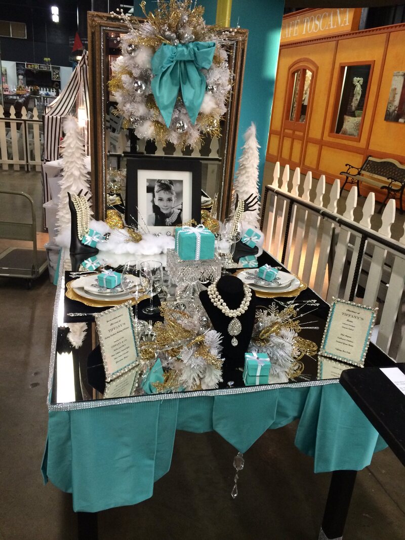
Bonnie Overman was making the rounds at the L.A. County Fair with a friend in 1996—they would have passed by all the usual crafty offerings like piquant jars of preserved foods and kaleidoscopic quilts—when they stumbled across something extraordinary: A cluster of tables, perfectly set and outrageously, decorated. Think Baroque clusters of figurines, imposing assemblages of fake flowers and vegetation, candelabras and hand-lettered menus.
No one was destined to sit at these tables; the people who had created them were all entrants in the annual tablescaping competition, a county fair tradition to which participants devote months of planning, countless hours of crafting, money, sweat and tears, all in the hopes of claiming Best in Show for the most creative, impeccably set table.
Her pal surveyed the scene and announced, “Oh my gosh, you could do so much better than this!” Overman’s fate was sealed.
Competitive tablescaping has been an L.A. County Fair tradition since the 1930s and typically has a waiting list for entrants, as only 20 are permitted. (The roster for this year’s competition, which takes place in September, is already filled.)
Many other fairs throughout the country also host tablescaping competitions. The rules differ from fair to fair, but generally follow a basic premise: Contestants are offered a choice of themes, including sometimes the option to create their own, a list of parameters (table size, for instance, or the disallowing of perishable goods), and then judged not only on the creativity of their table but on how perfectly it is set; judges will scrutinize the placement of a water glass as much as the perfection of hand-painted decor.
“My true love is creating things,” says Overman, an optician who lives in Pasadena, California. She recently made 15 scrapbooks for relatives and throws elaborate Halloween parties (last year’s theme: Arsenic and Old Lace). She entered her first tablescaping competition in 1997 (she didn’t score well) and hasn’t missed a year since. She now claims several Best in Show and First Place ribbons. They are displayed in her hallway, which has become a kind of museum of her tablescaping feats, including framed photos.
“I’m probably the most outlandish of everybody there,” says Overman.
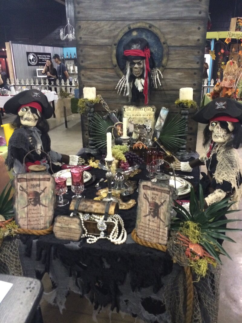
There was the Gone With the Wind themed table for which she crafted a pair of faux-glass doors from two picture frames, through which you could see Scarlett racing across the grounds of Tara, and draped them in green velvet curtains. (That one scored Best in Show.) There was the Pirates of the Caribbean table for which she made three skeleton pirates, one of which was crawling through a porthole. There was the Wicked table for which she hacked together a Wicked Witch figurine from a Halloween skeleton, witch's mask and costume wig, made bubbling green goo from felt, glued sequins onto a pair of tiny heels, and sewed taffeta flocking to the tablecloth in order to mimic costumes from the Broadway musical. The centerpiece was an aquarium castle painted to look like the Emerald City. (Overman has a penchant for filmic themes.) Tablescaping rules state that the milieu must also have a corresponding fictional menu; for Wicked, Overman dreamed up an all-green dinner that included pea soup and green apple pie.
“I approach it as a movie set,” she says. “It’s about the whole atmosphere.”
Overman spends as much as six months planning her tables. She has accumulated enough materials to fill two storage sheds in her backyard, and has a dummy table that she places over her own dining table in order to lay out her designs.
In addition to creative pressures, tablescapers must also have an encyclopedic knowledge of the lost art of how to set a table. The dishes, glasses and flatware must correspond with the proposed menu, and those items must be laid out perfectly, down to the direction of the knife blade. Mistakes cost competitors points, detracted by anonymous judges whose choices can sometimes feel arbitrary.
Overman has been dinged points for having too large floral arrangements, for misplacing a red wine glass (she disputes that ruling), and, once, for placing her pirate skeletons in the seats where her imaginary guests could have sat. That decision, which cost her 15 points, caused her to burst into tears.
“I’m telling you, if there’s one single fingerprint on the glasses, you’re going to get marked down for it,” she says. “We have to bring Windex, things to take lint off—it has to be absolute perfection.”
The judges’ rulings are publically posted, making the competition a favorite among fair attendees who like to quibble over the opinions, says Overman.
On “set-up day,” the tablescapers are given two hours to assemble their displays at the Fairplex in Pomona, California, where summer temperatures frequently climb into the 90-degree-Fahrenheit range. You sweat, says Overman.
“It’s almost tortuous, really,” she says. Nonetheless, the event is something she looks forward to all year. She’s bonded with a core group of about four regulars who are unapologetically competitive.
For this year’s L.A. County Fair, Overman says her design will have a rustic wedding theme. Her prize, should she take home Best in Show? A ribbon and a $200 gift certificate to Pottery Barn.
“It’s not for the money,” says Overman. “We do it for the ribbon. We do it to win.”
A corduroy road, also known as a log road, is a primitive type of road that's been in use for millennia and, when functioning, looks like this:
This type of road is used in areas where concrete, asphalt, or another type of surface isn't an option, or in times of war when just any kind of road will do. It was also used before modern pavement, in places, like swampy areas, where it became a necessity.
Recently, in Grand Haven Township, Michigan—located on the shore of Lake Michigan, about 27 miles west of Grand Rapids—such a road was discovered in the course of a construction project on 168th Avenue. Officials said the corduroy road was built circa 1855, "when [Grand Haven Township] was a logging town." They had known about a different corduroy road in town on a separate road about five miles away, but not this one.
"It was a pleasant surprise," Stacey Fedewa, a township official, told MLive. "We love finding our historical things here."
About 100 feet of road has been uncovered so far, the township reported last week on Facebook. They said Wednesday that they would be sending some of the logs to the Tri-Cities Historical Museum, for possible preservation, in part at the behest of some Facebook commenters who (perhaps unwittingly) channeled Indiana Jones.
"This is an absolutely amazing piece of history that should be put into a museum," one commenter, Marty Beck wrote.
After spending decades in a Philadelphia closet—a bit like an inanimate Harry Potter—an almost life-size statue of Saint Pantaleon is being returned to the church in Southern Italy that it was taken from.
Saint Pantaleon is a Christian saint from the 3rd and 4th centuries who is still popularly celebrated in Italy as the patron saint of doctors. In religious fashion, the statue shows the saint dying in agony while tied to a tree. And it was just by luck that the statue ended up living in Philadelphia for more than half a century.
According to Newsworks, the statue has its roots in the town of Montauro, in southern Italy. The statue was sent to the U.S. in 1946 to be used in a parade on the saint’s feast day. Eventually, they traveled to Philadelphia with it, and for whatever reason, they decided to leave it with Maria Concetta Carito, who put it on display in her house, where it spooked every generation of her family since.
Ed Nader, Carito's great-grandson, recently discovered that the statue belonged to the church in Montauro, while he was visiting in the town. Nader is planning to return the statue on his own dime.
"It is God's will," Nader's wife Kathleen told Newsworks. "I never questioned it. It's just, like — yes — that's what we do. We send it back."