Artist Daniel Monnier spent a couple of decades away before returning to complete his vision.
Night is falling around Daniel Monnier. Sitting on a small plastic stool, the 78-year-old, all-but-retired sculptor is patiently chipping away at the limestone wall of a tunnel-like path that runs along the Lot River between Saint-Cirq-Lapopie and Bouziès, in southern France. He’s carving the edges of what will soon be a polished limestone “mirror,” reflecting the river and the sky—if he calculated the angles right and the calcite crystals in the rock cooperate. “In this type of work there’s always surprises you aren’t expecting,” he says. “It’s not a bathroom mirror.” A few feet away, the first half of his project, a bas-relief of carved waves, fish, and rippling stone circles that covers 60 feet of the rock face, shines in the lamplight. He never thought he’d get to finish this work; after all, it had been more than 30 years since he started it.
That Monnier has been able to return to the work at all was due mostly to chance. A year earlier, on June 25, 2018, he recalls, a young man who worked as a guide on the boats that tour the Lot River was riding his bike at dawn when he ran into Monnier taking pictures of the original bas-relief. “We’ve completely lost track” of the artist, the man told Monnier, who hadn’t been back to see the work in 25 years. When the young man—Monnier does not recall his name—learned who he was speaking to, he was shocked. “He would have fallen in the river,” the sculptor laughs.
Monnier didn’t realize how popular his bas-relief had become in his absence. What had been a deserted path when he began and ceased working on the sculpture had become a popular tourist trail, and the story surrounding the unsigned work had grown to take on a life of its own.
A few days before Christmas 1984, Monnier was hiking from his home in Toulouse to visit family in Sainte-Foy-la-Grande, a village near Bordeaux—a trek of more than 120 miles. He wanted to avoid roads and decided to follow a small, intriguing dotted line on his topographical map. Along it, perhaps half-way to his destination, he discovered what felt like a secret tunnel. Along the Lot River, hidden at the base of the cliff, a path had been carved out of the rock to connect two small villages. The path was deserted and humid. Plants hung from the ceiling, water dripped along the walls. “It was wonderful,” says Monnier, who had been a sculptor for over 20 years at that point. He pulled out a pencil and drew, directly onto the wall, two lines, roughly 60 feet apart. The stone was “like an elephant’s stomach,” he says, smooth enough to draw on.
Monnier’s sculpture work is semi-abstract, and inspired by nature, he says. He’s made more than 100 pieces over the course of his career, some of which are on display in public buildings in France, as well as private homes around France, Switzerland, Spain, Austria, and England. After a career spent finding and transporting tons of rock from quarries all over France, he’d always wanted to work on a bas-relief, something that would be part of the natural scenery around it. He’d found the perfect spot.
The path Monnier encountered had been dug out of the cliff between 1843 and 1847, and is the only known river towpath in France to have been built this way. The workers hammered bars into the rock and then stuffed the holes with explosives—the grooves from this process are still visible on the rock face. When they were done, there was almost 1,000 feet of new, flat path, covered by the overhanging rock face and running just along the river. Horses and people used it to tow flat-bottomed barges called gabarres, laden with wine and other goods, up the river in the direction of Bordeaux. But only a few decades after it was finished, train service arrived in Bouzies, and in 1926 commercial shipping on the Lot River was stopped, so the path fell into disuse. The tow path was overgrown and basically ignored until Monnier stumbled upon it 60 years later.
It took him two years to get permits from four different local authorities to begin his self-funded work on a small, 43-square-foot section, with the condition that it be out of the public eye and didn’t ruin the natural scenery. Finally, in 1987, Monnier set up camp right on the towpath with little more than a sleeping bag, a mosquito net, and his tools. The people of Bouziès were understandably suspicious. “Seriously, they would have thrown me in the Lot,” he says. One woman came to yell at him about disfiguring the cliff face, and the police paid him a visit. “They used to come in civilian clothes and pretend to be fishing,” he says. But mostly they left him alone as he worked through the summers of 1987 and 1988.
At the end of his 1988 season, a surprise visit from M. Leblond, the local prefect and an art aficionado, gave him funding and allowed him to expand the project to cover the wall along 60 feet of the path. Leblond even arranged for a house in Bouziès where he could stay for the six months he worked in 1989.
Monnier was carving one of the final pieces into the bas-relief when he looked over and noticed movement in a polished swirl he’d carved. “It was the clouds drifting by in the Lot. Like a mirror,” he says. Calcite crystals in the rock made the compact stone reflective, he realized. He wanted to add a final piece, a polished limestone surface that would reflect the scenery.
But local authorities decided that he had done enough and ended the project there. Monnier was disappointed but resigned. “I packed everything up, took my tools and I left,” he says, promising himself he would come back one day.
While Monnier was gone, the area experienced a tourism boom. In 1990 the river was reopened for recreational boat traffic and in 2012, the picturesque village of Saint-Cirq-Lapopie was voted “Favorite Village of the French,” on a national television show. Hundreds of thousands each year came to visit, in a town with just 204 permanent residents. Bouziès, population 80, now averages 80,000 to 100,000 visitors.
According to a footstep counter on the path, 43,000 of these visitors walked along the towpath (it takes about an hour to go from one town to the next on foot) and passed Monnier’s bas-relief between June and November 2018. Many more rode by it on tour boats. “People were completely thrown by this thing,” Monnier says. “For them, when they walk here from Bouziès or Saint-Cirq, it’s the end of the Earth. And all of a sudden they come upon this.”
Monnier’s name always appeared in “official” stories of the bas-relief and on the town’s website, even though it’s not on the work. Monnier has been told, however, by hikers and tourists, that it was actually made by André Breton, the cofounder of Surrealism, who had owned a house nearby and sculpted the work on his daily walks. Others were sure that the mystery artist had died, or even that it was somehow related to the prehistoric paintings in nearby Pech Merle Cave. “Anonymity has always been my thing,” Monnier, who prefers to sign his work with a symbol, explains. “I never wanted to put my name in front of my sculptures.”
Three days after Monnier met the young man on the towpath in 2018, the town of Bouziès invited him back to finish the mirror. “They’re lucky I’m still here,” the 78-year-old jokes. No one wants to throw him in the river anymore. “Now, they roll out the red carpet,” he says. With thousands of visitors, the narrow path no longer allows him the luxury of camping on site, and it is now too crowded for him to work during the daytime. So he works at night, with the help of a spotlight and a generator. “The night goes by quietly, there’s no pressure,” he says. “I look up all of a sudden and it’s 4 a.m., and I didn’t see the time pass.” The project has had its challenges: A corner of the limestone mirror nearly fell on Monnier while he was working. The explosives used to clear the towpath had weakened the stone. He’s decided to leave that ruined corner as it is, as an artifact of the path’s creation. The long, thin grooves from the explosive excavation are also incorporated into the bas-relief.
Over the summer, the town of Bouziès organized dance performances on the towpath, with his bas-relief as a backdrop, and it has added two more Monnier originals to the town’s collection. The mirror, titled Incidence—and, in turn, the entire work itself, Le Lot—will be done by the end of September 2019. According to Gilles Raffy, the mayor of Bouziès, Monnier’s bas-relief “greatly contributed” to developing tourism. It’s not a bad story for an unsigned artwork on a deserted path. Even Monnier seemed surprised. “I hadn’t realized the impact this thing had,” he smiles. “I was gone for 30 years.”
If you're over six feet tall, you may need to duck to enter.
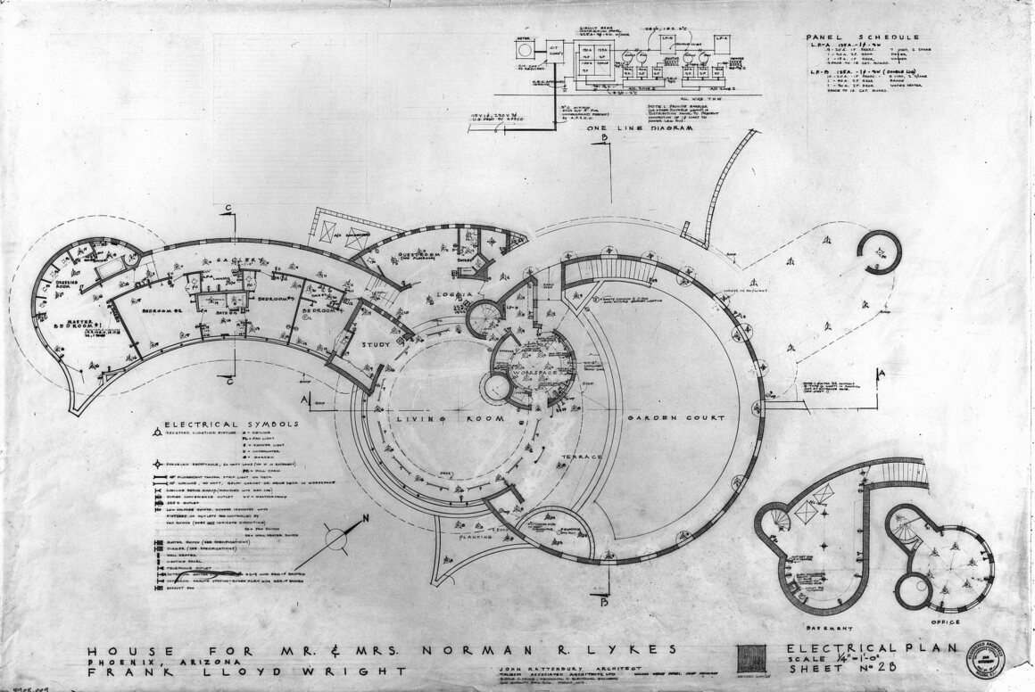
This month, two very different American homes are up for sale. One, in Phoenix, is a curvy, sand-colored behemoth that seems to ripple out of the Arizona mountains. The other, in Manchester, New Hampshire, appears to be built mostly out of concrete bricks. The first is stunning; the second, well, an acquired taste. Both houses, however, bear the distinction of being designed by the legendary architect Frank Lloyd Wright.
Though his name is now associated with sprawling masterpieces such as the iconic Fallingwater or the Ennis House, a Mayan-revival abode that’s seen many a film shoot, Frank Lloyd Wright designed many smaller, less famous houses in a range of styles. Approximately 380 Wright buildings remain standing today, most of which are still used as private residences, according to John Waters, the preservation programs manager at the Frank Lloyd Wright Building Conservancy. “You can look at his work and see a massive house in Los Angeles, a small house in Oak Park, and medium-sized houses dotted around the country,” Waters says. But while his styles varied, Wright’s goal was always a “thoughtful, intentional design,” he says.
To his credit, Frank Lloyd Wright always had a flair for his personal brand. When the would-be architect turned 18, he swapped out his given middle name “Lincoln” for “Lloyd,” giving his name a catchy three-meter beat, writes Thomas de Monchaux in the fall 2017 issue of the Frank Lloyd Wright Quarterly. Wright sometimes endowed homes with poetic names such as Hollyhock and Wingspread, betraying the usual convention of naming homes after clients. And he branded many of his buildings, which he considered “opuses,” with a small red square that bore his initials, de Monchaux writes.
Two Frank Lloyd Wright houses for sale simultaneously might seem like a big deal—an unusual glut in the market for buildings that are the brainchild of America's most famous architect. But at the moment of writing, there are actually 19 Frank Lloyd Wright homes for sale, according to a list assembled by Frank Lloyd Wright Building Conservancy. “At any one time, we have between 15 and 20 listings,” Waters says. By that estimate, you can expect around five or six percent of Wright houses to be on the market.
The house in Phoenix, also known as the Lykes House, seems to be the more beautiful of the two recent listings. Built in 1967, it is said to be the last home Wright designed before his death, and its floorplan consists of concentric circles that seem only natural in the surrounding mountains, where it overlooks the Phoenix Mountains Preserve. It’s the kind of house that lives up to Wright’s reputation for both muted grandeur and harmony with the surrounding landscape.
Unlike certain other distinguished Wright homes, Lykes has never had a leaky roof. Wright famously responded to complaints of leaking roofs and skylights by telling the disgruntled party to simply move their desk, chair, or whatever was getting wet; in 2001, Fallingwater nearly fell into the water. “His greatest weakness is a monstrous ego: though he talks of democracy, he has the manners and beliefs of a Renascence prince: at heart he is a despot,” Wright’s former friend, the historian Lewis Mumford, once wrote in a letter to the poet John Gould Fletcher. Mumford also noted that Wright, who was five foot seven, deliberately designed short doorways so anyone over six feet tall would bump their heads.
Wright’s house in Manchester may seem less architecturally impressive, but its sale is slightly more newsworthy. Known as the Kalil House, the building is one of only seven examples of the Usonian Automatic style, Wright’s later-in-life attempt at crafting an economical home in the wake of the Great Depression. Wright devised a concrete masonry system that relied on cheap concrete blocks around one foot wide and two feet long, which, in theory, prospective owners could order to assemble houses themselves. In practice, however, building the structures was more difficult than expected. “It was meant to be a relatively inexpensive house, making fine architecture within the reach of the middle class,” Waters says.
The Kalil House listing marks the first time a Wright-designed Usonian Automatic house has ever been listed on the market. It was built in 1955 for Toufic and Mildred Kalil and his wife Mildred, who lived just down the street from Isadore and Lucille Zimmerman. The Zimmermans had just commissioned a classic Usonian house from Wright, and the Kalils wanted one of their own, Waters says. The Zimmerman House is now the only Wright building in New England that’s open for public tours.
Though many of Wright’s homes are listed for sale at any given time, it may seem surprising that some linger on the market for several years. In 2017, The New York Times reported on the knotty process of selling a Frank Lloyd Wright home, which can be due to anything from a remote location to their inherently unique design. But, Waters says, “that’s true of all houses that are unique, and not necessarily what the market thinks it’s looking for at this moment.”
If you’re looking for something unique and astonishing, the Lykes House recently dropped in price by nearly a quarter-million dollars, from $2,985,000 to $2,650,000. If, on the other hand, you’re looking for something uniquely crafted from concrete legos, the Kalil house is listed for a more modest $850,000. Either way, if you’re over six feet tall, be prepared to duck.
Public squares have been so integral to communities around the world and throughout history that many venues are inseparable from the cultures that created them. Athens had its Agora. The Romans had their Forum. New York City has Times Square. And, as a new paper in the journal PLOS One has revealed, the ancient people of Maidanetske had their own version.
First identified through aerial photographs in the mid-20th century, the Tripolye mega-sites, including Maidanetske, are the remains of large Neolithic settlements in what is now Ukraine. Thousands of people lived on the sites until around 3000 B.C. The Cucuteni-Tripoyle culture that created them, which also extended into modern Moldova and Romania, used kilns for ceramic work, had animal-drawn sledges, and possibly invented the wheel. Though little is known about how the communities functioned socially, archaeologists are looking at the sites' architectural layout to better understand them.
“The number of possible geometrical shapes for the settlements is not that high,” says Aleksandr Diachenko, an archaeologist with the National Academy of Sciences of Ukraine who specializes in Triploye culture, and was not affiliated with the study. “Settlement structure really matters in terms of social organization.”
Maidanetske was about the size of early Mesopotamian cities, and was built in concentric rings, about 100 miles south of Kyiv. A team of Ukranian and German archaeologists looked at the layout of the 3,000 houses and determined that 13 large structures—with areas of 2,000 to nearly 13,000 square feet—likely acted as venues for public events and social functions. These would have been large gatherings, perhaps political in nature.
“The unique spatial layout of the settlement plans suggest a unique social configuration,” says Robert Hofmann, an archaeologist at the Institute for Pre- and Protohistory at Kiel University in Germany, and lead author of the paper, via email. “The living together of 10,000 (±5,000) people was only possible through (democratic) sequential decision-making processes, made at different societal levels.” What he means is that the large community at Maidanetske relied on these civic centers in order to function; they were Neolithic negotiation rooms, for all manner of prehistoric problems.
Hofmann’s team compared the structures at Maidanetske with more than 100 others in various other ancient European settlements, and determined that they must have been critical parts of life in the settlement. While the dwellings were two-storied, the mega-structures were just one floor, and some lacked roofs, suggesting an open activity space. The unroofed ones tended to be located in central plazas, while smaller, roofed buildings may have served specific groups, farther from the city center. Researchers think most could hold more than 1,000 people at a time. Maidanetske was clearly an organized place, and persisted for 350 years.
But like all ancient cities that appear to us today as ruins, it was eventually abandoned. The archaeologists speculate that over time, the larger meeting spaces became more important than the smaller ones, which fell into disuse. Hofmann suggests that changes to the social organization—perhaps increasingly centralized in a way that discouraged or suppressed participation—was unsustainable.
“The case of Tripolye mega-sites seems to be an example,” Hofmann says, of “how humans should not govern. Dysfunctionality of social institutions, lethargy, and lack of democratic participation contribute to deterioration of the social fabric in a human society.”
It’ll be interesting to see what archaeologists of the distant future will make of Washington’s National Mall, Beijing’s Tiananmen Square, or London’s Trafalgar Square.
Dickens spent the days before his death counting casks of whiskey.
On June 6, 1870, Charles Dickens strolled into the cellar of his country house, Gad’s Hill Place in Kent, and surveyed his liquor stores. The day before, wine merchants at Joseph Ellis & Sons had dropped off a cask of good sherry. If Dickens wanted whiskey, he could dig into stone jars of it, including some of the 30 “very fine” gallons that had been delivered the previous January.
But Dickens was expecting company—his daughters were coming to visit. So, as he often did when guests came to visit, the writer took stock of his intoxicants and recorded the inventory in a clear, firm hand in his household notebook. Three days later, after a sudden brain hemorrhage, Dickens was dead.
The notebook remained. Passed for years through the hands of various manuscript collectors, the yellowed notebook, bluish with Dickens’ spidery script, was auctioned off on September 24 by Sotheby’s, London. Selling for £11,875 or $14,641, it was one of many Dickens-related items auctioned off from the collection of Lawrence Drizen for more than two-million dollars.
“There’s a hugely passionate collector community for Dickens,” says Gabriel Heaton, a Specialist from Sotheby’s Books and Manuscripts Department. Those that participated in the auction had their pick of Dickens classics, including first editions of Great Expectations, which sold for $217,350, and A Christmas Carol, which sold for $116,438. But the humble household inventory had something these great works didn’t: It was one of the last things Dickens wrote.
Like many estate-owners of his time, Dickens maintained a hearty liquor cellar, which he tapped into to entertain the guests who frequented his country estate. He kept casks of sherry, pale and dark brandy, whiskey, and rum. His personal alcohol use “was pretty normal for the time,” says Heaton (the Victorians liked to drink). He didn’t keep gin, which was considered a drink of the poor.
Unlike other men of his class, who might have commissioned staff to track the daily ins and outs of cellar stock, at the end of his life, Dickens chose to attend to this household matter himself. “He was a man who was always full of energy,” Heaton says. Yet by June 1870, while Dickens was still hard at work on his last novel, the never-completed The Mystery of Edwin Drood, Dickens had begun to lose mobility. Unable to walk the grounds, his attention turned inward.
For Heaton, the creation of this painstaking household inventory is evidence that, faced with this declining mobility, Dickens focused on routine, and on daily matters of food, drink, and entertaining. “It’s a poignant record of the final days of one of the greatest writers in the language,” Heaton says.
Only 20 khayamiya artisans are left, in one dusty alley in Cairo. Can e-commerce save them?
Behind a dense curtain of colorful patchwork, Ekramy Al Farouk begins stitching the quilt he started days ago. He hopes to sell the finished product later today. But as he learned from his father—who learned from his father—the laborious, painstaking process of khayamiya can’t be sped up.
It’s not unusual for one piece of this ancient Egyptian art—a decorative appliqué textile made nowhere else in the world—to take weeks to complete. Patient artisans like Al Farouk, 44, who began stitching when he was 12 years old, train for years to master its intricacies.
“Learning khayamiya goes through different levels,” Al Farouk says. “It takes a lot of time to learn even the simple pieces, and I had to learn those before the professional ones."
Generations of khayamiya artisans like Al Farouk have plied their trade in this dusty alley—a quiet stretch of storefronts in Islamic Cairo that’s overshadowed by the neighborhood’s famous towering mosques and minaret-topped mausoleums. Known as Sharia Khayamiya—the Street of the Tentmakers, or the Tentmakers Market—the alley is named for the art form's original purpose: tent decoration. Like many forms of art, it's taken different shapes over the years. Nowadays vibrant quilts and detailed cushion covers hang in the alley, bringing life and color to the market’s otherwise drab, deteriorating walls.
Some believe that khayamiya dates back as far as the pharaohs. But the business of selling it today looks different than it ever has before. And not just because these artisans—the last 20 left in the world—are surrounded by roaring mopeds and other marketeers on cell phones.
Tourism on the Street of the Tentmakers, as in much of Egypt, plummeted after the revolution in January 2011. As protestors swarmed downtown Cairo, embassies urged travelers to change their plans. The market, then bustling, grew quiet. Khayamiya’s primary target—tourists—stayed home. Those who braved a trip to Egypt skipped the chaotic, potentially hazardous maze of Old Cairo, opting instead for visits to the heavily guarded Great Sphinx or Great Pyramid of Giza.
For an art form like khayamiya, which has always relied on tourism, lack of foot traffic can sound like a death knell. Yet that’s only one of the challenges khayamiya faces today. Another is its perception as archaic, particularly among younger Egyptians. Many locals—including those who might have once taken up khayamiya themselves—see the traditional textile as outdated.
Séverine Evanno, who collects and sells khayamiya through her online store and Etsy shop, Couleurs du Nil, says kids today don’t want to follow in their fathers’ artisanal footsteps. “Young people are not patient enough to learn the job,” she says. “They prefer to drive taxis or Uber. They have no time to learn the stitchwork.”
Or any of the other things that go into making khayamiya. Artisans first sketch their design on paper, then poke tiny holes along the paper outline and use soot or powder to create a subtle stitching roadmap on the canvas. Once that’s in place they can begin laboriously hand-stitching each detail. It’s a process that takes hours, days—sometimes even weeks.
"The difficulty of crafting khayamiya is having patience, concentration, and skill," says Al Farouk.
(And the ability to multitask. Khayamiya artisans, who work in the cramped back corners of their shops, also have to decorate their storefronts, market their work, and bargain with shoppers.)
Yet the result is something wholly unique—a fusion of color and artistic detailing unlike any other art form. Those intricacies are what drew Evanno to the Street of the Tentmakers in the first place. After one walk-through, she couldn’t get enough.
But after living in Cairo for six years, Evanno and her Egyptian husband moved to France, where she’s from. Evanno yearned for a way to stay connected to her second home. That’s when it hit her: khayamiya. By selling khayamiya in her online shop, she always has a reason to return to Cairo and the Street of the Tentmakers.
She’s since become a familiar and welcome face here—having an Egyptian husband and speaking the language helps too—who’s granted the rare opportunity to see the real khayamiya community in action. Behind the hand-stitched curtain, Evanno has found a mixture of kinship and competition.
“There’s a very special link between these artisans,” she says. “But they’re also competitive.” As business owners, khayamiya artisans tend to chase the selling trends, then innovate when there’s downtime. “If one of them starts to make a beautiful pattern and it becomes successful, the others won’t be happy, and they’ll start making the same one. That’s why you can go in every shop and see identical patterns.”
This approach can make it tough for individual khayamiya artisans to stand out. That’s where big smiles and sharp sales skills used to come into play. But with fewer tourists in the market these days, such opportunities have dwindled.
Beyond the internal rivalries bubbling within the khayamiya community, the remaining 20 artisans are also struggling with external competition. A new crop of khayamiya-style artwork—fabric replicas—is attracting local buyers who love the look of hand-stitched khayamiya but can’t afford the price. (A khayamiya quilt costs $200 or more, while two yards of replica fabric is $25.)
The khayamiya artisans consider these knockoffs a form of forgery. But Evanno—who also sells fabric replicas in her Etsy shop—thinks both versions play a role in preserving the tradition. “The khayamiya patchwork is like a painting, and the fabric is like a photo of the painting,” she says. “They’re not the same, and they’re not for the same use or the same population.”
Traditional hand-stitched khayamiya products are equal parts artwork and decor. The quilts, cushion covers, and wall hangings are not meant to be cut or tailored by the owner. For purists, that’s akin to ripping a painting in half.
So is treating the replicas like a true fabric. In recent years, some creative Egyptian buyers have begun adapting their cheap replicas into khayamiya clothing and curtains.
Some grumble that this approach is changing the traditional purpose of khayamiya as art. Evanno and others, however, argue that clothes and curtains are simply “changing the purpose to keep it relevant.”
Relevance is key to khayamiya’s survival. And nothing is as relevant today as the internet. Evanno’s digital storefront attracts shoppers from all over the world. But she’s hardly the only one selling khayamiya online. Traditional artisans now partner with Egyptian Etsy shop owners to reach customers where they are: on the web.
“Every shop owner has some partner working on selling khayamiya,” said Alshimaa Moustafa, who sells Al Farouk’s work in his Kufic Khayamiya Etsy shop. “Since they don’t have online shops [themselves], they sell their products wholesale, and the [online] shop owner markets and sells them in his own way.”
Time will tell if this ancient patchwork has found a digital salvation. But it’s the best hope for khayamiya’s survival. The fact that khayamiya is now available to anyone with an Internet connection and an Etsy account is what might ultimately save it from extinction.
Ironically, just as the khayamiya industry is adapting to the brave new world of online shopping, tourism in Egypt is starting to come back. Before the 2011 revolution the country counted as many as 14 million tourists a year. That figure dipped to 5 million in 2016. But in 2018, 11.3 million tourists visited Egypt, according to the global economic database CEIC.
Meaning the brick-and-mortar khayamiya shops may yet rebound. But only if travelers take the time to visit.
“People go to Egypt for sites like the pyramid[s] and the Sphinx,” says Evanno. “So many tour operators leave this area off their itinerary. You need to have tourists who ask to see something different, who ask to go off the beaten path.”
For those who do, the Street of the Tentmakers is waiting for them, right where it’s always been—alive with color, charisma, and khayamiya.
Games are a serious matter, and they have been for thousands of years. Fun is fun, but games need rules. Before the dawn of proprietary games—the ones in boxes—most board games didn’t come with instructions, though. The rules were passed on orally, and that’s one of the reasons that ancient games still played today, such as mancala or backgammon, have murky origins. Now, an interdisciplinary team of software engineers, game historians, and archaeologists is attempting to piece together the lineage and rules of ancient board games—with modern technology.
Board games are one of the oldest documented forms of leisure. It is hard to tell when hide-and-seek or chopsticks came along, because they don’t leave any material evidence, but game boards and playing tokens have given archaeologists a lot to work with. They were etched on the landscape, left or lost in habitation sites, and even buried with the dead (for playing in the afterlife). They occur all over the world, from Viking hnefatafl to Chinese liubo to a mancala variant in Borneo, and involve a range of boards, dice, and pieces. And games spanned social divisions, from the general public, some of whom played on game boards incised into surfaces in temples, to ancient royalty, who had suitably luxurious game paraphernalia.
“Tutankhamun had four senet sets in his tomb,” says Cameron Browne, a computer scientist at Maastricht University, referring to an ancient Egyptian game about the passage to the afterlife. Browne is the head of the Digital Ludeme Project (lude from the Latin, “to play”), which is using archaeological evidence and modern game rules to figure out how hundreds of ancient games and their variants were played, and changed over time and by location.
As far as the archaeological record goes, board gaming began with senet, nearly 1,800 years before Tut was even born. About 700 years later, in ancient Sumer, the Royal Game of Ur was important enough that its rules were written down—actually incised on a cuneiform tablet. (Otherwise, rules were almost never set in stone.) The names of many ancient games have slipped through the cracks of history, so researchers identify them by what remains. There’s “33 Circles” from Egypt, “10-Ring” from Bronze Age Crete, and the Middle Eastern “58 Holes.” Since the rules have been lost over time, the way many ancient games were played is based on speculation. With so many games, and so many variations, Browne’s work isn’t merely an archaeological-meets-ludological project. It’s genealogical, too.
“We’re really dealing with families of games,” Browne says. “The mancala games, the chess-like games, the tafl games, card games. Each of these probably have their own distinct family.”
Like the humans that invented them, games evolved over time. Board sizes have changed, pieces have shifted shape, and rules have mutated as games have been passed along and slowly fanned out across the map.
“The Silk Road is a perfect example” for how the games spread, Browne says. “Many of these games started in the Fertile Crescent and progressed through Europe and Asia.”
And as they spread they left behind a convoluted lineage of adaptions and local flavor. For example, according to Ulrich Schädler, a games historian at the Swiss Museum of the Game and an editor of the journal Board Game Studies, the aristocrats at Versailles in the 17th century played a languid form of trictrac, a backgammon variant. When the game got to the banking Brits across the channel, with a sense of “economy of time,” it was compressed into 15-minute bouts.
This all adds up to a complex, poorly documented, and global family tree, and that makes defining any given, long-forgotten rule set a challenge. Games changed hands across cultures, over the course of millennia. Many games fell out of style, disappeared altogether, or evolved into something unrecognizable. The archaeological record is fragmentary at best, and game compendia—such as Alfonso X of Castile’s 1284 Libro de los Juegos—are few and far between. What games did leave, in some cases, were boards and spare pieces, which in turn has led to a lot of guesswork among amateurs, enthusiasts, and interested insiders. The same Howard Carter and Lord Carnarvon who opened Tut’s tomb proposed what is now a common play style for 58 Holes. Modern game experts can only pick up the pieces.
“Lost rules are made in a very superficial way by people who don't really know games. From archaeologists, philologists, I've read so many,” Schädler says. “They're made up by people who have never played a game, or don't know their mechanics very well.” Bringing some order to this complicated history might take something more than speculation.
At the Fourth Annual Board Game Symposium in New York in September 2019, Walter Crist, an anthropologist with the Digital Ludeme Project, briefly described how their project is dealing with this—by going from “we can’t know what the rules of the game are” to figuring out what the rules must have been, using artificial intelligence.
To do this, the researchers model each game using "ludemes" (literally, “game memes”) to digitally reconstruct the games based on their fundamental conceptual information. The ludeme idea breaks down the game’s form—its physical components and any known rule set—and separates it from function, or how those components are employed in reality. Ludemes are game genes, and once the genetic information is mapped, the Digital Ludeme Project can calculate the “ludemic distance” between games, or the number of steps necessary for one game to evolve into another. The ludeme concept makes all game information more manageable pieces of a much larger puzzle. By adding or removing any one component, a game might be a step closer to another one, and then with historical and archaeological data, the researchers can tell whether one game borrowed from another. Then, in a crucial step, the ludemes are loaded into a game system made specially for the project—LUDII game software—and the computers go to work by playing every game thousands upon thousands of times in different variations.
In a game of Boggle—proprietary, invented in 1972—players shake an enclosed box of 16 cubes, each inscribed with a different letter on each side. Once the cubes settle, players try and make as many words as they can by connecting the face-up letters. This is precisely what the LUDII software is doing, with game simulations in the place of letters, and functional games in the place of words.
Schädler has long worked on reconstructing ancient games without the assistance of artificial intelligence, and says that to find out if a set of rules works, you need to play it a lot of times to find glitches where the rules break down and leave the game unplayable, unevenly matched, or impossible to win. A veteran of many, many of these playthroughs, Schädler is excited about the Digital Ludeme Project.
“If we have a large number of ludemes, elements that make up a rule set, we can perhaps see that certain ludemes go together,” he says. “You can simply let the computer play 10,000 times and this will give you a result as to whether or not these rules work.”
With so many ludemes involved with each game, “what would have taken a lifetime of playtesting can be done in hours,” says Eddie Duggan, a games historian at the University of Suffolk. “Once the game has been programmed using the LUDII game system to model, play, and analyze the games, it will be possible to determine a game’s ‘interestingness’ or game quality.” The more test runs a given game gets in the machine learning system, the better the Digital Ludeme Project team can understand how the game would most optimally operate.
“Our reconstructions will also, crucially, provide confidence scores for our reconstructions,” says Crist, the team’s anthropologist, “to communicate our conclusions about the likelihood that these rule sets could reflect the reality of the past.”
The game family tree operates like an evolutionary tree, and can be tracked through a method called computational phylogenetics. After each game is “boggled,” and thousands of different rule sets are tested, the Digital Ludeme Project determines how the game fits in with others, and can track their changes like in a game of telephone. Between points A and B, Duggan notes, there are many small steps, so the project provides opportunities to both interpolate new games and optimize existing ones.
“As well as revealing something about ancient games,” he says, “it is likely that new games will be discovered that were not known or played in the ancient world.”
The Digital Ludeme Project’s ultimate goal is to make hundreds of reconstructed and optimized ancient games available online for everyone to learn about and enjoy.
“Games without rules—play—is something all animals do,” says Duggan. “But one day somebody used a stick to scratch a line in the dirt and started to arrange pebbles or seeds along the line according to rules and invented a game. That is when we became human.”
As the project continues, Browne says they’ll pay special mind to quality and historical authenticity. The compendium of fun is set to officially publish in January 2020, though some of the games are playable now. To, Duggan it all illustrates our collective adaptability—when applied to the task of fun.
“Whether we are modern board game players, Vikings, ancient Romans, ancient Egyptians, ancient Babylonians,” he says, “we are all Homo ludens, the species that plays games.”
If you’re human, the waters of Mono Lake aren’t for you. Besides being an otherworldly strain of beautiful, the Californian body of water is salty and very basic, with a pH of 10—the equivalent of detergent—in addition to levels of arsenic around six times what is considered safe for drinking. No fish live in the lake, but some animal life finds a way, namely ones that thrive in the toughest conditions (known collectively as extremophiles). Mono Lake's inhabitants have names that refer to their hostile home: brine shrimp and alkali flies. Now, another hardy species can be added to Mono Lake’s list of aquatic denizens—nematodes, including a new, arsenic-adoring species from the genus Auanema.
The creature, described in the journal Current Biology, is a roundworm with a couple of unique evolutionary traits, chief among them the capacity to survive more than 500 times the amount of arsenic that is fatal for humans. But James Lee, a nematologist formerly of the Sternberg Lab at the California Institute of Technology, which conducted the research, wasn’t all too surprised to find them.
“What’s remarkable about extremophilic nematodes—in fact all extremophilic species—is how much they have to reveal about resilience, and the innovative strategies they use to survive on this planet,” he says.
The newly discovered species of Auanema has a few other evolutionary tricks up its oral cavity. It has three sexes—female, male, and hermaphrodite. Lee says that the male and female Auanema may help preserve genetic diversity in established populations, while the hermaphroditic worms are uniquely suited to trailblazing into new areas, since they reproduce solo. The nematodes are also viviparous, meaning that instead of laying eggs like most nematodes, they have live births.
Lee and his colleagues are particularly excited about the new Auanema species’ arsenic resistance, which, while documented in two other nematodes, has never before been apparent in an extremophilic one.
“We believe this could shine new light on how arsenic moves through and affects animal cells,” he says, “an open question that’s especially important since arsenic is one of the most common environmental toxins that affects humans.
The nematodes at Mono Lake also confirm a long-held truth: that nematodes are not only one of the most robust creatures on earth, but they are also among the most abundant. In 1913, nematologist Nathan Cobb wrote that “if all the matter in the universe except the nematodes were swept away, our world would still be dimly recognizable … we should find its mountains, hills, vales, rivers, lakes, and oceans represented by a film of nematodes.” Mono Lake would come through clear.
“These animals have really mastered how to survive on this Earth,” Lee says. “We could really learn a lot from them.”
The cartographic curio was probably an educational tool.
Sewing needles and pins have a vexing habit of wandering away or inserting themselves into fingertips. In the 19th century, someone looking to corral her pointy supplies probably wrangled them with a pincushion. And around 1820, she may have pierced a needle through Charleston, New York, or Hudson Bay, on a diminutive, plush map of North America.
This map, printed on silk, is currently up for sale via Daniel Crouch Rare Books with an asking price of £1,800 ($2,212 in U.S. dollars). The sellers suggest that the cartographic curio—still studded with eight pins—was probably a mass-produced educational tool devised to teach Britain’s Georgian-era schoolgirls a little about the continent on the other side of the Atlantic Ocean.
Needlepoint was a common activity for girls and women at the time, and there was a societal push to marry lessons with leisure. “There was a lot of debate about how to do primary education in the early 19th century, and much emphasis on ‘doubling up’ exercises—learn a skill and some information at the same time,” says Matthew Edney, a geographer and cartographic historian at the University of Southern Maine and the Osher Map Library.
The sellers write that pincushions were first peddled by toy shops in the 18th century, and that the map aligns with other educational games for kids that were being produced at the time, including jigsaw puzzles with cartographic designs. Grown-up customers across the economic spectrum were a little map-happy, too: Brainy, curious shoppers snapped up cartographic things tiny, twee, and portable, from itty-bitty almanacs to 18th-century pocket globes small enough to fit in an outstretched palm.
The map measures only about two inches in diameter, so a fair amount of accuracy and nuance were sacrificed for the sake of space. But a fine-grained lay of the land wasn’t the point, says Edney. Instead, this map is “part of a long tradition of ‘map fluff’ that is not interested in high detail and great accuracy, but in simply saying, ‘I’m a map!’ and in giving a broad geographical outline. As something touted for educational use, it should be simplified so as to be easily read.”
The maker of this plush map chose a few of the “most obvious” cities and geographic features on the continent, says Nick Trimming, of Daniel Crouch Rare Books. If more had been squeezed onto the map, the labels would have smashed into each other and become illegible.
A smattering of facts about the continent are printed on the reverse side. The mapmaker, who may have been the London-based publisher and printer William Darton Jr., noted that North America “is bounded on the east by the Atlantic Ocean; on the west by the Pacific Ocean,” and that “while the northern limits have not been exactly ascertained, it is supposed to contain about 20,000,000 Inhabitants.”
(The 1820 U.S. census counted 9,625,734 residents of the states and territories, including free white people, enslaved people, non-naturalized residents, and free people of color—a tally that included some Native Americans.)
There are obvious limits to how much one could learn about the world from one small map of a single continent—especially one that glosses over the vast majority of its features. But this small wonder is a reminder of how big the world is, and how much there is to learn about it.
The first reconstruction from a flesh-and-blood mammoth looked more like a pig.
In 1799, a reindeer farmer named Ossip Shumachov began a strange yearly ritual. He was the leader of a community of Evenki, an indigenous group from the Russian North, and while hunting for wild reindeer with his family, he noticed a strange, dark lump poking out of the ice. Shumachov did not know what it was, wrote the invertebrate paleontologist I. P. Tolmachoff in his aptly-named 1929 paper “The Carcasses of the Mammoth and Rhinoceros Found in the Frozen Ground of Siberia.”
But Shumachov did know that Russia’s famously short summers thawed huge quantities of ice, resulting in a mile-wide river of meltwater, so he returned each year to this frozen mystery, waiting patiently for the mass to reveal itself. Five years later, it did. The long-dead and largely intact carcass of a mammoth had slipped out of the ice and onto the sand of the Lena River delta, Tolmachoff wrote. Shumachov, face to face with a prehistoric beast of the Ice Age, did what any enterprising person would do: He chopped off its tusks and sold them.
The man who bought the tusks, a Russian merchant by the name of Roman Boltunov, traded approximately 50 rubles worth of goods for the nine-foot-long tusks—more money than Shumachov’s village would have seen in several years, writes John J. McKay in his book Discovering the Mammoth. Boltunov was busy was making his way down the Lena River, selling and trading his wares, but he couldn’t resist mammoth tusks in good condition. Tusks weren’t rare in eastern Siberia, but these tusks were special: The man who sold them said he’d plucked them from an actual mammoth that was nearby, freshly exposed and rotting in the cool air. According to McKay, Boltunov convinced (or perhaps bribed) Shumachov to take him to the carcass. When the two arrived, Boltunov took some measurements on a sheet of paper and later, after leaving the mammoth, made a drawing of the creature from memory, Tolmachoff wrote.
The drawing is crude, and depicts a strange swine-like creature with tusks pointing in opposite directions. The sketch “is a very good example of a reconstruction hindered by extreme ignorance of basic animal anatomy,” paleoartist Mauricio Anton wrote in an email. “The body and legs are shapeless, and each foot ends in a sort of hoof-like structure unlike anything seen in elephants (or any other animal).” Even so, this somewhat laughable caricature was the first reconstruction of a mammoth known to science that was based on more than bones, McKay writes on his blog Mammoth Tales. Much to the chagrin of stuffy Russian biologists, it played a pivotal role in science’s early understanding of mammoth anatomy.
When Shumachov and Boltunov reached the carcass, it had already been defaced, literally, by scavengers, as well as Shumachov’s dogs, according to McKay. Whatever meat was left exposed to air had been eaten, but the majority of the mammoth was still there: its fat body and trunk-like legs russeted in hair. Boltunov’s sketch did not faithfully portray the mutilated body in front of him, but rather imagined the mammoth in its prime, standing on all four legs.
Two years later, a merchant named M. Popoff sent Boltunov’s sketch to Mikhail Adams, a botanist at the Imperial Academy of Sciences. Adams rightfully described the drawing as “very incorrect,” McKay writes, but the drawing was still published in the Russian newspaper Technological Journal.
In the summer of 1806, led by Shumachov and ten other members of the Evenki tribe, Adams visited the site by the Lena River to recover the mammoth’s remains, as Adams writes in his 1807 travelogue “XXIII. Some account of a journey to the frozen sea, and of the discovery of the remains of a mammoth.” Unsurprisingly, Adams found an even more decrepit, putrefying corpse, one that was missing a leg, almost all its flesh and organs, its trunk and tail, and one of its forelegs. Undeterred Adams bagged all the mammoth he could, including two intact feet, one ear, a still-colored eye, and some preserved hide, the last of which required a team of ten men to drag it away from the sandy bank, he wrote. Adams also collected approximately a pood (a Russian unit of measurement for the weight of a kettlebell, the equivalent of 36 pounds) of the mammoth’s long hair.
Though Adams was only able to scrounge up the meager, sloppy remains of the megafauna, the carcass represented the most complete remains known to science. It was just the fifth reported discovery of a flesh-and-blood mammoth, none of which had ever been recovered in time for European naturalists to study them. At the time, European naturalists knew the mammoth was an extinct relative of the modern elephant. Georges Cuvier, commonly called the father of paleontology, established extinction as a fact in a 1796 paper that compared the skeletons of Indian and African elephants against that of a fossilized mammal he would later name the mastodon, according to an entry on the Biodiversity Heritage Library blog.
Adams’ Siberian mammoth was missing one elephantine component: its tusks. So the botanist bought another set of mammoth tusks, passing them off for the originals, and sent everything to the Imperial Academy of Sciences in St. Petersburg in several packages. “The mammoth was the first complete carcass to be brought back to ‘civilisation,’ even if most of the flesh had gone by the time it reached St. Petersburg,” Adrian Lister, a paleobiologist at the Natural History Museum in London, writes in an email.
Several countries over, European naturalists had gotten word that a largely intact mammoth carcass had been discovered—though they were certainly confused by the drawing they received. In St. Petersburg, the German naturalist Wilhelm Gottlieb Tilesius got to work reassembling the skeleton. Adams had written his own account of the discovery, but he was a botanist, and had not even made a drawing. So Tilesius had only Boltunov’s sketch for reference, which he called “a poor drawing of a monstrous figure,” McKay writes. Aside from making the mammoth look like a pig, the drawing contradicted other narratives about the carcass, including Boltunov’s own notes. But the drawing preserved certain aspects of the body that had long deteriorated when Adams found it, such as the mammoth’s ten-inch tail and a shaggy coat of hair, which Adams mistook for a lion-like mane.
Tilesius ultimately based his reconstruction on the skeleton of an Indian elephant housed in the museum. Unsure where to place the enormous tusks, he guessed they pointed outward, like defensive weapons (they did not). The reassembled skeleton, over 16 feet long and 10 feet tall, went on display in 1808, making it the first mammoth skeleton ever to be mounted, Lister says.
In 1860, the Academy of Sciences created a leaflet offering 100 rubles to anyone who could produce a complete mammoth skeleton, a reward that could increase to 300 rubles if the carcass still had its meat and hide, Lister writes in Mammoths: Giants of the Ice Age. But the Adams expedition had left a bad taste in the mouths of local and indigenous people of Siberia. By taking 10 men from Shumachov’s village of just 40 or 50 people, McKay notes that Adams likely deprived the village of most of its adult men who would have needed to hunt during the summer to stock up for the harsh Siberian winter. In McKay’s eyes, even if the men were paid, they might not have had a choice in such a transaction, as the forced exploitation of indigenous labor propped up many scientific advances at the time.
According to Adams, Shumachov’s village also saw the discovery of a mammoth as a sign of future calamity. As Shumachov told Adams, the last time someone unearthed a mammoth in the area, their entire family died shortly after. With all this in mind, even 100 rubles seemed too meager a reward for such trouble. No preserved carcasses were reported for nearly a century; those found were kept secret or even chopped up into pieces and thrown into the sea, Lister writes.
Around the same time, unable to find another mammoth carcass, the German naturalist Karl von Baer tried to hunt down Boltunov’s fabled drawing. It had been lost long ago, but Baer tracked down a copy and published the reproduction in an 1866 paper with an attribution to Boltunov, noting the merchant’s contribution of key details of the carcass that Adams missed or never saw in the first place. According to McKay, every other paper that published the drawing used it as an example of the ignorance of rural Siberians, and entirely missed its scientific significance. There is no evidence that European scientists ever tried to contact Boltunov or Shumachov to interview them as witnesses to the original carcass. Shumachov even traveled to St. Petersburg to protest how Adams had taken sole credit for the mammoth he originally discovered. “Of course, cultural arrogance is hardly unique to that century,” McKay writes.
In the 21st century, considered alongside the bounty of mammoth carcasses scientists have discovered in dedicated expeditions to Siberia, Boltunov’s drawing does not hold up. It breaks the convention of anatomical drawings taken in the field, which should be rendered as the animal appeared in the ground. Mauricio Anton, who painted one of the most widely-propagated images of mammoths, politely eviscerated it. “The pioneer of paleoart, American artist Charles Knight, claimed that no one can pretend to be able to depict extinct animals if he or she is not able to draw modern animals competently,” he says. The Boltunov sketch “seems to be the work of an artist who could not be able to draw a modern elephant, or even to describe it.”
But no one ever expected the Boltunov drawing to be anatomically accurate, or even good. To paleoartist Brian Engh, who painted a mural of Pacific mastodons in the Western Science Center in Hemet, California, Boltunov’s sketch is actually commendable. “What that artist did is basically a simplified version of the process we paleoartists go through when reconstructing prehistoric animals,” he says. “We look at the available fossil remains and try to figure out the animals in question is related to. We then try to clothe that skeleton in soft tissues from the closest relative where soft tissues are known.” Defending Boltunov, Engh points to certain pig-like features in elephant skulls, such as a flat snout, big molars, and front-facing tusks.
As a paleoartist, Engh says he’s constantly surprised by how unfamiliar people are with the skeletons of common animals, even those we eat. “I'm constantly amazed by the myriad ways that subtle differences in soft tissue can result in a significantly different looking organism,” he says. Consider birds, for example, which can have eerily similar skeletons but look drastically different in real life, once coloration, plumage, and wattles are taken into consideration.
Today, the skeleton, known as the “Adams mammoth,” stands on display at the Natural History Museum Vienna. Its mummified skin still clings to its head, and the tips of its tusks now rightly spiral inward. Boltunov’s drawing, meanwhile, is still reproduced in textbooks. While the sketch does technically fall under the realm of wonky paleoart, it also represents an earnest attempt at citizen science that was, in its time, laughed off as an example of how little rural Siberians knew. Boltunov did the best he could to capture a beast that must have seemed almost mythic, from an age scientists still have yet to entirely understand.
Just 10 men are permitted to hunt and pickle 2,000 young seabirds on a desolate island each year.
“It’s not all that tasty,” admits Murdanie Macleod, a merchant marine who lives just outside Ness, Scotland. “If it were available year round, I’d still only eat it once or twice.” The Northern Scottish delicacy called guga, or “gannet” in Gaelic, is a pickled, boiled seabird that has been variously described as tasting like salty goose or fishy duck—occupying the uneasy chasm between fish and fowl. Yet every August, “The Men of Ness” venture into one of the world’s most treacherous ocean passages to cull and pickle 2,000 young seabirds from a remote, rocky island.
But the future of the hunt is in doubt. Tens of thousands of animal-rights advocates have protested and petitioned against the practice, and in 2017, the small crew of dedicated hunters received death threats. The tradition’s survival is also threatened by the aging and shrinking population of Ness, the sole town where it now survives.
Much of the ire focuses on the hunters' targets: three-month old gannets that are too young to fly. Fluffy, white newborns offer little muscle and too much fat, but once they’ve fledged, the sleek, blue-eyed fishers become lean and tough. The best-tasting guga are called “three tufts,” a reference to the downy feathers they shed before they’re ready to take flight. They are, proverbially, teenagers.
It makes for a rather odd, but no less celebrated meat. Donald S. Murray, a Ness native and author of Guga Hunters, tells a joke about its preparation: “You put a stone in a pot of water with the bird and set it to boil; when you can pierce the stone with a fork, the bird’s fully cooked.” The coarse meat does require prolonged boiling to soften it and remove the salty flavor stemming from a fish-based diet. “You’ve got to change the water, too” says MacLeod, who grew up eating guga and recalls the whole town awaiting the hunters’ return at Ness’s pier each year. “If you don’t, it’ll be mega salty.” Most wives demand their husbands cook the bird outside, the two agree.
A properly cooked guga, says Murray, tastes like “mackerel-flavored chicken.” Traditionally served with milk and potatoes, guga is eaten in September, after the hunters’ return. The taste is practically unknown outside of Ness.
As the home of the last guga hunters, Ness feels like a holdout in more ways than one. Its residents are some of the world’s last Gaelic-speakers—a language spoken by only one to two percent of the Scottish population. As the traditional tenured-farming system known as “crofting” sunsets, they’ve chosen to remain, even as others move to the mainland for job opportunities. In this context, guga stands out as one of the few singularly Gaelic culinary traditions remaining today in Scotland. The average Niseach, or Gaelic-speaking Ness resident, will only eat one or two of these odd, oily birds a year. Still, they are steadfast in keeping the hunt alive.
Hunting and eating guga is an ancient tradition, and part of the regional Gaelic identity. While the earliest written record of it on Ness's go-to hunting ground—a desolate island called Sula Sgeir—is from 1549, hunting guga in this way is believed to date back thousands of years. Throughout Scotland, men hunted cliff-side gannet colonies, handing down techniques from father to son since time immemorial. “There is a repository of skills, a generational accumulation of knowledge, for how to survive in these areas, which itself is important,” says Murray. For the Niseach, hunting and eating guga became “a way of telling the outside world, ‘We’re not like you, we are distinctive.’”
The hunt first came under scrutiny in the early 1900s, amidst a flurry of concerns over British bird populations. With the extinction of several species of native birds in the preceding centuries, recreational hunting came into conservationists’ crosshairs, and the gannet population at one point tallied a mere 30,000 in Scotland. Prominent biologist Sir Julian Huxley, viewing the guga hunt, wrote to Geographical Magazine’s readers that he hoped “public opinion and the county council … [would] soon put a stop to this practice.” In 1954, the Royal Society for the Protection of Birds passed the Bird Protection Act, which banned the killing of seabirds, including guga, across the whole of the United Kingdom.
The law made one exception: Every year, 10 men from Ness could apply for permits to cull 2,000 guga on Sula Sgeir, a desolate island 40 miles north of their port town. It was a traditional hunting ground, but one of the hardest to reach. “It’s a very risky stretch of water [to get there],” says Murray. “You’ve got the depth of the Atlantic and the narrowness of the Minch [strait].” “The Men of Ness,” a tight-knit and selective group of Niseach licensed to hunt, haven’t missed a season since.
The exemption resembled those granted to Native American and Aboriginal Australians to hunt or harvest at-risk but traditional foods. “It’s the last stand in Scotland where Gaelic culture is strong. If it dies in Ness, it hasn’t got a chance anywhere else,” says MacLeod. Once spanning Ireland and most of Scotland, the Gaelic language and culture has slowly receded to the western fringes of those countries. Even into the 1970s, children could be punished for speaking Gaelic in school, part of a several-century history of British suppression of local culture and language. An ongoing spat over English versus Gaelic road signage embodies the modern cultural jostling. The road signs in Ness are all in Gaelic.
Sula Sgeir is now the site of an annual cultural pilgrimage, the last stand for the guga hunt. Surrounded by choppy waters, the jagged, uninhabited island atop sheer, 75-meter cliffs is dotted with the ruins of centuries-old stone bothies used by hunters of centuries’ past. Few have seen the island in person, and even fewer have set foot on it. Jaded by condemnation from outsiders, the hunters have silenced themselves to reporters and documentarians—even the man who skippers their boat each year declined to speak to me. The hunt itself has only been visually documented twice since 1954.
The BBC’s “The Guga Hunters of Ness” juxtaposes modern footage of the hunt with footage from 1959 to highlight the synchronicity of their technique, a testament to a timeless tradition. “Everything you do in Sula Sgeir has been done by people a long time,” said hunter John “Dodds” MacFarlane. “The same process: sleep in the same bothies, step on the same stone pathways. Nothing has changed.” He’s filmed as a toddler in black and white in 1959, helping his father push a wheelbarrow of gannet. He’s filmed again in 2011 as a middle-aged man in his final years as leader and defender of the guga hunt. “There’s a fierceness to his spirit. He is indomitable,” says Murray.
The hunt is arduous, and the men waste no time. After the eight-hour boat ride (once done in wooden rowboats), the men haul two weeks of water, food, clothes, tools, and tents on their backs up a steep cliffside from a small dinghy. Working in pairs, they catch the pre-fledged birds from the edge of precipitous cliffs: One traps each bird by the neck with a 10-foot pole before lifting it to his partner, who dashes the young bird’s head with a wooden stick. “From the time I catch it to the time it’s killed is about two, three seconds,” said MacFarlane. The men efficiently feather, scorch, brush, singe, de-bone, gut, salt, and pickle the finished product. The filletted birds are draped one over the other in a “pickle pile” to preserve in their own juices along a seaside cliff. “Each bird has to sort of [sit] on the next one to hold the pickle in the pile,” said MacFarlane.
The hunt functions as a retreat as well. There, the men speak Gaelic and huddle together in a small bothie to read from the Bible, also in Gaelic. As it was with generations of Presbyterian Niseachs past, they bar themselves from working Sundays. On Sula Sgeir, the men reconnect with a culture they see receding in Ness, a town itself in recession: The population has halved in the last 50 years as young Niseach leave home for mainland opportunities.
It is a quiet tradition in Ness. Back at the pier when they return, the men divide the harvest and sell it to neighbors. While each roughly four-pound guga sold for £15 a piece this year, according to MacLeod, the men don’t do it for money. The profits often only cover the cost of taking two weeks off from work. Dividing a mere 2,000 guga in a town of just more than 1,000, the September tradition of eating guga in Ness is hard-earned, short-lived, and soft-spoken. “The story of the hunters themselves has never really been heard,” Murray told The Independent following the release of his book. “It has always been the animal rights groups calling the shots."
In recent years, the internet has amplified outside opposition to guga hunting. MacLeod observed an uptick in activism from 2008 onwards, citing the advent of social media. With fears over extinction ameliorated (conservationists noted a sixfold gannet population increase across the 20th century), opposition has centered on the manner in which the birds were dispatched. Outrage over “birds [being] bludgeoned to death” can now be harnessed and directed. One petition tallied 70,000 signatures.
The opposition turned vitriolic after the Ness Football Club’s 2013 inaugural “World Guga Eating Championship,” whereby contestants raced to consume a half-gannet and a side of potatoes. (“It was done as a bit of a laugh,” says MacLeod.) “Stop this insane, monstrous … chick-eating contest! We are not in [the] middle ages anymore and idiotic things like this must be stopped!” read one petition. Derision hit a fever pitch when several hunters received death threats in 2017, traced to the Southeast of England.
“I don’t think he realizes how long it’d take to get up here,” says MacLeod of the threat. “And sure, he might kill a guy, but he’d never get off the island alive himself.” Murray describes the opposition as “a form of colonialism.”
The organization tasked with overseeing the gannets tells a less-alarming story. The Scottish Natural Heritage, who issue the Men of Ness their annual permits, recorded a modest 2.2% population increase in Sula Sgeir’s gannet population between 2004 and 2014. A spokesman for SNH also has said in a statement, “We are also satisfied that … the method used to dispatch the birds is not inhumane.” In 2010, a request from the Scottish Society for the Prevention of Cruelty to Animals to ban the hunt was denied by the Scottish government.
Year after year, the Niseach live with the hunt on a thread. The opposition remains entrenched, while Ness’s population continues to age. For MacLeod, however, one problem seems to solve the other. “As soon as someone says, ‘You have to stop your tradition,’ it’s like, ‘Get stuffed, now we’re definitely gonna keep doing it,’” he says. It’s certainly not just about pickled seabird for Murray. “The hunt is an act of defiance.”
How the mysterious, millennium-old, stateless Order of Malta outlived its contemporaries and established a place in the modern Middle East.
In a dimly lit room in northern Lebanon, a metal twin bed frame sat pushed against a window. Ghadire Abdelrahman, propped up by a heap of pillows, was silhouetted by the sun outside. The 26-year-old’s leg lay painfully stretched off the bed, a swollen foot wrapped tight in bandages. Next to the road outside, a blue sign indicated “Syrian borders” with an arrow. The nearest border checkpoint was a 10-minute drive away. “At least you don’t hear bombing,” she said.
Beyond the sign, a line of low green hills spanned the horizon, marking the end of Lebanon’s northernmost district, Akkar. On the other side lay the Syrian governorate of Homs. In fuzzy border areas like this one, some Lebanese people speak Arabic with Syrian accents. Syrians and Lebanese intermarry, with personal and political ties dating back to Ottoman times. The border crossing in Akkar, nicknamed the “Gateway to Syria,” served as a main route for cargo trucks. People living at the border, an area known for its limited infrastructure, would rather drive to the city of Homs than the more distant Beirut to browse shops. Relations between the two countries have always been fraught and sometimes violent, but the neighbors have, on and off, kept fluid boundaries.
As the civil war erupted, grew, and persisted, more than half of Syria’s population was displaced, either internally or across borders, including the people—some 1.5 million in total—who began streaming into Lebanon. Commercial trade routes were strangled. In their place, contraband operations smuggled weapons, supplies, and even soldiers across the border through Akkar—a Sunni-majority area, like Syria, in religiously diverse Lebanon—to shore up opposition to the Assad regime (though Lebanon’s Shia Islamist political party and militant group Hezbollah supports Assad). In the other direction, refugees fled bombings and attacks. They came via both official and unofficial channels, many empty-handed save the clothes on their backs.
Before the war, Ghadire and her sister, 28-year-old Munira, lived with their widowed mother in the border village of Al-Hosn, which rebels occupied in 2011. They had an old stone house with its own olive grove, and a little vegetable garden where they grew cucumbers and tomatoes. After the revolt, the Syrian military retaliated with an embargo, followed by kidnappings and disappearances. After their cousin was killed in a street bombing, Ghadire’s family fled to Damascus. By then the fighting had escalated. They spent eight months in a settlement for displaced people. Rebels approached, warplanes whizzed overhead, supplies dwindled. “People started eating grass and anything they could find,” said Munira.
Many Syrians had already left, but Ghadire and her family instead went back north to Homs, where they were able to rent a small house. Steady bombardments became routine. Through them all, Ghadire took classes in chemistry. Munira got a degree in Arabic literature. Years passed. Then, in July 2016, Ghadire was studying late one Ramadan night when a bomb blast slammed her backward and shattered both her legs. No one knew who dropped it. “I came in to help her,” said Munira, who carried her unconscious sister to the nearest hospital, “I thought she was dead.”
Hospitals in Homs had been targeted in attacks since the start of the war, and medical workers treating patients risked government detention—or worse. The beleaguered doctors still did what they could to keep Ghadire alive. “They put a cast on my leg, but I needed an operation. They wrapped my hip, but I needed treatment,” she explained.
Meanwhile, the influx of refugees into Lebanon slowed as parts of Syria were declared safe. Tens of thousands of Syrians, spurred by the Lebanese government, even began crossing back. This past winter, Ghadire set out against the trickle of returnees. Aided by an uncle living there, and plagued by constant, now years-long pain, she arrived, unregistered, in Lebanon. She came to neglected Akkar, afflicted with Lebanon’s highest poverty rates, in search of medical care—a reason that might have been unthinkable before.
Her mother and sister followed a month later. Once a short drive, the trip took over 24 hours in a series of choreographed rides. Akkar still suffers from a lack of medical services, but it is a staging ground for the Order of Malta—a nearly-1,000-year-old Christian chivalric order that pre-dates the dawn of the Crusades. There, the Order operates Mobile Medical Units (MMUs), roving, retrofitted minibuses staffed with local doctors and nurses, that serve as treatment rooms, consultation spaces, and medical dispensaries.
“Imagine me, living under bombs with fear in my gut all day, in the worst conditions possible,” said Ghadire, who relied on strong painkillers in Homs, and is still mostly unable to walk. Through the Order, Ghadire has received medical scans, physical therapy sessions, and a pain management plan. Mingling with other Syrian refugees over the course of her visits, she said, “I saw worse cases than my own.” Energized, she sat up in the bed, wearing a wine-colored jumpsuit, her hijab covered in dusky rose blossoms. “This helped me get out of my depression.” Outside the window, the hilly borderland loomed—still reachable, but now half a world away.
“We’re living,” said her sister Munira. “Because we’re not dead.”
The Order of Malta seems like an anachronism in the 21st century. A contemporary of the Teutonic Order and the Knights Templar, it was recognized as an extraterritorial Catholic sovereignty in 1113 by Pope Paschal II. There are more than 13,000 members spread between continents, still known in medieval-era parlance as “knights” and “dames.” Most are lay members and, according to experts on its history, the Order has always been strictly non-proselytizing, but the highest echelons of membership—Knights of Justice and Professed Conventual Chaplains—must adopt monastic vows of poverty, chastity, and obedience. Protected for centuries under the pope, the Order of Malta remains independent. Lacking any fixed territory beyond a pair of administrative headquarters in Rome, it is both global and spectral, with its own government and constitution. It maintains diplomatic relations with more than 100 countries and has outposts around the world, from Berlin to Bamako. Like Palestine, the Order has a permanent observer status at the United Nations. Members on diplomatic missions can even travel with Order of Malta passports.
Sovereign and independent, but without borders of its own, the organization has developed a quirky geopolitical agility. Its relief agency, Malteser International, has a far-reaching humanitarian portfolio, bringing, it states, the “balm of Christian charity” to 120 countries. Also known as the Knights or Hospitallers of Malta, the Order has a global staff of some 42,000—mostly medical personnel, from a range of religions—and almost twice that many volunteers. There are national associations empowered to set their own humanitarian agendas, and no central, governing authority for these programs. The Order’s staff has provided disaster relief after typhoons, earthquakes, and volcanic eruptions, as well as care for people afflicted with ebola or leprosy in West Africa and Southeast Asia, and operates specialized dementia facilities in the United Kingdom, Germany, and France.
In medieval and early modern times, and even into the 20th century, members were culled from Europe's noble families. Membership is still invitation-only and new recruits must be sponsored by existing members, but the emphasis, the Order states, is on “nobility of spirit” rather than aristocratic roots. Their aid budget comes from private donations and members, although the Order's healthcare programs often receive financing from national governments. Membership is global, but the highest concentration is in Western and Southern Europe. National associations are empowered to set their own humanitarian and medical care agendas.
A cornerstone of the Order’s relief and diplomacy work takes place in border zones—places that are often off-limits to traditional state actors. Hypermobile by choice and by tradition, they serve populations who are themselves mobile as a desperate consequence of war, natural disaster, or upheaval. At the Turkish-Syrian border, the Order runs a field hospital for refugees. They are facilitating resettlement for Yazidi populations in Iraq. Medical teams joined Italian ships to assist migrants at sea (until Italy’s right-wing government closed their ports). As a diplomatic entity, they only work publicly, visibly, and in partnership with governments, but the Order's reach is such that roughly half of all new refugees in Germany in 2014, for example, received aid from them.
In Lebanon, the Order operates four MMUs, which patrol the country’s remote, neglected areas and act as satellites to nine brick-and-mortar health centers. They were first deployed in southern Lebanon, after the 2006 war between Israeli and Hezbollah forces. During that conflict, the Order’s local healthcare center had its windows and doors blown out and stayed shut for 33 days. But patients still picked through the broken glass at night to fill their prescriptions—and kept a log of their own to indicate who had taken what.
“Sometimes you’re there because no one else is there,” says Ghade El-Zein, Director of Health and Social Services at the Tyre-based Imam Sadr Foundation, named for a famed Shia reformer who disappeared during a trip to Libya in 1978. The foundation collaborated with the Order to comanage the MMUs. “When we can move,” she adds, “we move.”
In a quiet village in Akkar, not far from where Ghadire was recovering, a long line gathered at midday in front of the MMU, a white, modern minibus with windows discreetly covered and the symbol of the Order—a red shield with a white, eight-pointed Maltese cross—on the side. In the air-conditioned bus, a feverish nine-month-old baby lay fitfully on a padded examination table. “I come here very often,” sighed his mother. “I have six kids, so each takes their turn getting sick.” A man in chipped eyeglasses handed the doctor a lab report he had brought with him. Another man carried an eight-year-old boy with a fractured ankle through the door.
In line was a Syrian woman in her 60s. In her hometown of Talbiseh, she spent every night for a full year in a cellar, escaping bombing. Then she began having difficulty breathing. After coming by bus to Lebanon six years ago, she learned that she had a blocked artery and required surgery. After the operation, phone calls to her home in Syria, where her husband stayed behind, went unanswered. “I’m afraid of going back,” she said. “I don’t know what I’ll find there.”
“I didn’t know there were even people like this, who spend their lives in such misery,” said the doctor, 70-year-old Abdallah Khoury. “If we didn’t exist, what would these people do?” He began to examine the boy with the broken ankle, and then held up a stethoscope to listen to his lungs. “This is an asthmatic family,” he explained. Though Khoury sees hundreds of patients, he recalls many of their medical histories by sight. “I like to stay in my bus,” he added, “and listen to the lives of people.”
In its earliest incarnation, the Order of Malta was dedicated to the care of the sick and poor, then it took up arms to defend Christian territories in the Holy Land, before reverting back to its original mission, many centuries later. Lebanon has the largest proportion of Christians among Middle Eastern countries—roughly 40 percent—but a century ago, there were twice as many. Active in Lebanon since 1957, the Order still works to safeguard Christian interests, but—in a move that might seem paradoxical—only through strictly interfaith charity work. “Our culture here in this region has always been a culture of living together,” explains Oumayma Farah, General Delegate of the Order’s Lebanese Association. “The idea was not to serve Christian minorities but to serve everyone, and to empower Christian minorities to stay in their land.” She adds, “One day, when the Syrians go back to their homes, the MMU can go back with them.”
In 1985, the same year that the Order of Malta began its collaboration with the Imam Sadr Foundation, the body of a Dutch priest, 44-year-old Nicolas Kluiters, was found in a ditch in Lebanon’s Bekaa Valley. It was a decade into the country’s 15-year civil war. In response, the Order of Malta made the decision to construct a new medical center there. “Any sensible person would think it’s too dangerous,” says Farah. “We thought, this is where we have to be to respond to our mission.” The Order partnered with a local Sunni humanitarian organization to bolster support. “They told us, you are crazy to go there,” says Farah. “But one thing our faith tells us is not to be afraid.”
Order of Malta staff spent months gaining trust there, and eventually the center became a refuge, where Muslims and Christians gathered for medical and psychological support. But criss-crossed for centuries by fighters and fortune-seekers, missionaries and mercenaries, sages and sultans, the Levant and its turbulent histories cast long shadows. During the first uncertain months, the Order took a precaution. It kept its emblem—a relic from its medieval association with the Republic of Amalfi in Italy—hidden. “It’s still a cross. You’re in a very sensitive area,” explains Farah. For many, there were still boundaries. “For them,” she adds, “the knights are always the Crusaders.”
Leafy, church-filled Aventino is one of the seven hills of Rome, and home to one of the city’s more cryptic attractions: the Aventine Keyhole. The tiny, bullet hole–shaped opening in an otherwise unremarkable green door is hidden by an omnipresent queue of tourists, off their idling Segways and jostling for a peek inside. Through the hole, designed by the artist Giovanni Battista Piranesi in the 18th century, one can see a tiny, zoomed-in view of St. Peter’s Basilica, two miles away, perfectly framed by laurel trees. The experience captures three sovereignties in one field of vision: Italy, the Holy See, and the Order of Malta.
The green door is the entrance to an old hilltop priory that serves as the extraterritorial headquarters of the globetrotting knights. After their defeat in the Holy Land centuries before, and before they settled in Rome in 1834, the Order controlled the island of Rhodes and then Malta, reflected in their mouthful of an official name: the Sovereign Military Hospitaller Order of St. John of Jerusalem of Rhodes and of Malta. Behind the green door, a sprawling, sun-drenched garden with carefully cubed hedges leads to the Magistral Villa, where the Grand Masters of the Order are elected in clandestine meetings similar to papal conclaves. Leaders, who should be over 50 or have 10 years of the necessary experience, are selected from the Order’s knights and serve life terms. (British-born Grand Master Matthew Festing resigned in 2017 following a dispute over the distribution of condoms—as revealed by Wikileaks.)
In the ornate, chandeliered Chapter General Room, portraits of the 78 deceased Grand Masters hang in rows, beginning with the Blessed Gerard, an 11th-century leader who traveled to Jerusalem to found the Hospitallers' first monastic hospital. Christian eschatology has infused the gallery. “People say that when the wall space runs out, that will be the end of the world—the apocalypse,” says Valérie Guillot, who coordinates guided tours, available only on Friday and Saturday mornings. There is currently room for a dozen or so more paintings.
The Aventino compound once belonged to the Knights Templar. After the militaristic Christian knights were dissolved in the early 14th century, the Order of Malta inherited their contemporaries’ properties, along with their duty to defend Latin Christendom, as detailed in the book The Knights Hospitaller by the medieval historian Helen Nicholson—one of many monographs shelved in the Order's magistral archives in Rome. Once known for their care of the poor and sick in Jerusalem and then Acre, the Hospitallers participated in multiple campaigns at the front line of the Crusades, advancing the Church’s interests along battle-scarred Christian-Muslim borders. Pope Honorius III extolled the Order’s militarization, praising the fighters, Nicholson’s history explains, as “defenders of the orthodox Christian faith, their hearts inflamed with the fire of the Holy Spirit.”
In another gallery in the villa hangs 17th-century oil paintings depicting fierce naval skirmishes, primarily with Ottomans and North African corsairs. After the Order of Malta seized control of Rhodes in the early 13th century—ousted just two centuries later by Ottoman Sultan Suleiman the Magnificent—they established a naval league and earned a reputation as skilled mariners. Aspiring knights were selected from noble families and underwent four tours of duty at sea, each lasting half a year, known as “caravans.” These included raids on Muslim ports and ships, with the knights-in-training acting more like buccaneers.
“They created a very particular image of themselves which might be bizarre,” says Emanuel Buttigieg, a historian at the University of Malta, through the dual functions of fighting and nursing. But both were perceived as sacred duties. Unlike the Templars, who proudly trumpeted their military prowess, the Order “kept a lower profile,” simultaneously continuing work as interfaith healers. That’s one reason a holdover from medieval Christendom kept swinging, through the Renaissance, the Age of Discovery, the Enlightenment—and beyond. “The reason that the Hospitallers survived is that they were a bit more canny about how they presented themselves,” says Buttigieg.
From 1530 to 1798, the Order had its seat of power in Malta. Jean de Valette, 16th-century Grand Master of the Order, founded the island’s capital, still called Valletta, following the dramatic Ottoman siege of Malta in 1565. The armed Hospitallers clashed with Ottomans and Mamluks, whose rivalries the Order capitalized on, according to Buttigieg. Both sides captured a reserve of slaves to serve as free labor. But the idea of a clash of civilizations—Christendom versus Islam—“simplif[ies] what is a much more complex and interesting picture,” the historian says. Despite the Order’s long-held opposition to Islam, more nuanced relations emerged across the fractious Mediterranean. In the 1750s, when Sicily launched an embargo on Malta, Tunisians, who wished to assert their autonomy from their distant Ottoman masters, stepped in to provide a supply of meat.
At the turn of the eighteenth century, Napoleon Bonaparte and French revolutionary forces invaded Malta, plundering the island’s churches. The Hospitallers retreated into an amorphous, ignominious exile. Pope Gregory XVI allowed the Order to move to Rome a few decades later, coinciding with a push for the now-landless Order to rededicate itself solely to its original medical, humanitarian mission. During World War I, they established ambulatory clinics aboard moving trains—precursors to the modern MMUs.
Despite their modern humanitarian reputation, the Order is still—through its longevity and perceived secrecy—the subject of a number of conspiracy theories. These can involve, at times, Satan, Freemasons, or JFK—and, more recently, American foreign policy in the Middle East. In 2007, a widely reported op-ed in the Dubai-based daily al-Bayan, written by a member of the Jordanian parliament, urged readers to attack the Order’s Cairo embassy. Under the headline “The Knights of Malta—more than a conspiracy," and referring to the Order as "the most mysterious government in the world,” their piece linked its charitable missions to the George W. Bush administration's evangelist-inflected military campaigns. Several years later, the Pulitzer-winning investigative journalist Seymour Hersh accused top-ranking U.S. officers in Afghanistan and Iraq, among them General Stanley A. McChrystal, as being members or supporters of the Order of Malta, which both McChrystal and the Order have denied.
The Hospitallers, going back centuries, have always had a particular focus on aiding populations on the move, from pilgrims to refugees. But, according to Grand Chancellor of the Order of Malta, H.E. Albrecht Freiherr von Boeselager—also a Bailiff Grand Cross of Honour and Devotion in Obedience—its Catholic-inspired charitable mission “is not normally carried out in weapons.” While it once chased Muslim armies and others from Christian-patrolled lands and waters, the Order now aids safe passage. Working across continents, says Buttigieg, “has given the Order this feeling that it’s an organization that is beyond borders—that it is there to serve people, irrespective of borders.” This is a far cry from past centuries, when, from hard-won strongholds in the Levant and along the Mediterranean coasts, the Order “was also about making war across borders,” Buttigieg says.
The mandatory training for knights, known as caravans, still exists, but has been repurposed to refer to a 10-month volunteer program in Lebanon. From autumn to early summer each year, German and Lebanese youth delegates tend to the disabled during daily visits to group homes and psychiatric wards. On one recent beauty-themed session in a women’s facility in the mountains, German caravan volunteers brought along nail polish. Patients are still referred to as “Lords,” a distinctive fusion of devotion and humanitarian work. But the Order’s landscape of loyalties has shifted—and softened. “I think we survived a thousand years,” von Boeselager muses, “because the Order was always able to adapt.”
The Ramadan-deserted streets radiated with furnace-like heat. A woman in a black abaya hung a carpet in the sun, then darted back into her house. A chipper weather report on the radio promised “températures effrayantes,” frightening temperatures. But on looming mountaintops in the distance, patches of snow glittered incongruously. Rising from the plains of eastern Bekaa Valley, which runs like a scar through the middle of Lebanon, is Mount Hermon, at 9,232 feet. It straddles Lebanon and Syria, part of the highlands that include the Golan Heights, which were seized in 1967 from Syria by Israel. Recently a controversial new settlement was inaugurated there: Trump Heights.
An energetic and gregarious doctor, 62-year-old Jamal Ismael, head doctor of the Bekaa Valley MMU, was out making his rounds. The MMU was parked that day in the village of Aakaba, where people belong to the distinctive Druze ethno-religious group. Its arrival is usually announced by both mosque and church loudspeakers. Ismael entered the van and instantly began bantering with patients, who gathered to shake his hand. He chided one older woman for not taking her diabetes medication: “You have to take the medicine. You have to.” Nurses thumbed through a reserve of canary-yellow folders stocked with patient histories. A pair of sisters came in, each with hormonal imbalances—one dressed in the traditional black robe and long white veil of the Druze faith, the other in hot pink sneakers and acid-washed jeans. “That’s the freedom of the Druze,” Ismael remarked cheerfully.
Another Order of Malta patient, 45-year-old Sabah Daoub, lives with three of her six children behind an abandoned storefront in town, wedged between a gas station and a kanafeh shop—one of many belly-up businesses rented out to house refugees. When the family arrived from Syria six years ago, Daoub sought out treatment for her traumatized son, Mohammad, who was stricken with fever. Years later, he still suffers from recurrent nightmares and visits an Order of Malta psychologist. "They told me it's normal. He’s been through a lot,” Daoub said. “Even when someone sets off a firecracker, he panics.”
Just 139 miles long and 35 miles wide on average, present-day Lebanon is the product of a 19th-century, European-born cultural imaginary: the modern nation-state. Once part of a great swathe of the Ottoman Empire known as “Greater Syria,” it has been conquered and ruled by a patchwork of successive powers: the Fatimid and Mamluk dynasties, with their centers in Egypt, and Frankish Crusaders. Lebanon was parceled off as a French mandate in 1923—touted as a haven for its Maronite Christian majority—and gained independence in 1943.
Characterized as a bridge between cultures and continents, Lebanon is unusually religiously diverse for any country, especially one in this region, but is in practice a chessboard of strained sectarian identities. It counts 18 official faiths and, until 2009, religion was listed on all Lebanese identification cards—information considered as essential as surname or date of birth. A balance of powers is maintained by constitutional law: the Lebanese president must be a Maronite, the prime minister a Sunni, and the speaker of the parliament a Shia.
This shaky coexistence was tested by a protracted civil war. In 1975, followers of the Christian Kataeb Party massacred 27 Palestinians in a Beirut suburb, sparking 15 years of fighting, during which a sniper-filled, militia-manned demarcation line divided West (Muslim) and East (Christian) Beirut. “In a lot of people’s heads, the war never ended,” says Ismael, a Shia Muslim with four sisters who all married Christians and converted. Years of conflict “compartmentalized the different religions,” he says. “It even divided Christians between each other, and Muslims between each other. It was like a crescendo.” The Order was particularly active during the civil war, which saw the construction of eight of its healthcare centers. “The beautiful thing that we do,” says Ismael, "is this cross goes everywhere. It reaches Druze, it reaches Muslims, it reaches Christians.”
Syria loomed large over the war in Lebanon, occupying the country during its duration and for another 15 years after—swept out, finally, during the popular Cedar Revolution of 2005. Syria’s own civil war broke out six years later. In 2011, poverty rates in Lebanon’s northern border areas already hovered at over a third, stretching the limits of Lebanese hospitality to migrants fleeing the war. It was another opening for the Order.
If nations are built on shared histories—imagined or real—then modern Lebanon might well be formed by shared traumas. Sudanese, Iraqi, Palestinian, Syrian: one in four people in Lebanon is now a refugee. As the Lebanese novelist Dominique Eddé has observed, “Every Lebanese invents a personal Lebanon for a country that does not exist.” The same is true of its borders, places of fluidity and flux that can be harsh or welcoming, depending on the circumstances under which one encounters—or reinvents—them.
At the height of their presence in the warring Holy Land, the Hospitallers maintained some 40 fortified outposts. A sprawling, fabled Crusader castle, the Krak des Chevaliers, was their largest, occupied from 1142 to 1271. Originally built by the Emir of Aleppo (though some accounts dispute this), it held an Order of Malta garrison of 2,000 troops and horses to fortify advancing Christian armies, with reserves of supplies lasting five years. According to the author Diana Darke’s account, skeletons uncovered in the castle’s ornate loggia were entombed with their shields and swords.
Sitting on a hilltop just five miles from the border where Syria meets Lebanon’s Akkar district, the castle became a base for rebel fighters traveling overland from Lebanon early in the Syrian war. The regime of Bashar al-Assad bombarded the UNESCO-listed castle in 2013, and cornered rebel forces blew up its medieval-era staircase, obliterating a Latin inscription on a window lintel from its crusader days: “Grace, wisdom and beauty you may enjoy but beware pride which alone can tarnish all the rest.” Today the fortress still towers, eroded and damaged but remarkably intact for now, over the village of Al-Hosn—Arabic for “fort.” And down in the village, there was, or perhaps still is, a stone house and vegetable garden—the ones that sisters Munira and Ghadire Abdelrahman once shared with their mother, and that they were forced to flee at the start of the war.
Germany’s Iron Curtain is now the Green Belt, but turning the old border into a haven for wildlife has taken much more than just letting it be.
For most of its length in Germany, the Iron Curtain was actually a steel fence, and Kai Frobel could see it from his childhood bedroom in the West German village of Hassenberg. The barrier, more than 10 feet tall and made of a kind of mesh specially designed to offer no finger-holds to would-be escapees from East Germany, snaked through the Steinach Valley. It divided the landscape into the domains of documents. On one side, the North Atlantic Treaty Organization. On the other, the Warsaw Pact.
The border made a surreal neighbor. Frobel remembers flares shot off at night to expose potential escapees, and the occasional distant thump when a stray deer set off a landmine. Other encounters with it were more disturbing. Frobel’s father, the local doctor, was once called to treat a farmer maimed by an East German landmine that had washed into his fields during a seasonal flood. When Frobel was 16, he stood on top of a car and watched as East German authorities evacuated and leveled an entire village that was too close to the fence. Plumes of dust drifted into the sky as house after house was knocked to the ground.
Equipped with trip-wire machine guns and patrolled by guards with orders to shoot to kill, the border was called the “Death Strip” by West Germans.
For decades, it was a fact of life, so entrenched that, for those who grew up along it, it seemed it had always been there. Though in retrospect it was short-lived—first sealed in 1952 and dismantled in 1990, soon it will have been gone almost as long as it existed—to those living in its shadow in the 1970s and 1980s it seemed built for the ages. Frobel, an avid amateur photographer, has plenty of landscape shots in his archive, but almost none of the border itself. “I just assumed it was always going to be there,” he says now.
The 866-mile border was one of the most recognizable and politically charged changes to the landscape following World War II. But all of West Germany was transforming, too. As it had in many parts of the world, industrial agriculture was turning what for millennia had been a patchwork of pasture, fields, and forest sprinkled with small towns into a much more uniform landscape—a monoculture of barely distinguishable crops.
In a twist of fate that reverberates decades later, the land on the Death Strip and some areas around it were protected from the plow and the combine. “In the ‘70s, the landscape was drained, cleared, planted,” Frobel says. “The border was the last refuge.”
In the 30 years after the crumbling of East Germany, known as the German Democratic Republic (GDR), the border between east and west has transformed again, into the Grünes Band, or Green Belt, a swath of protected land that runs from the Baltic Sea in the north all the way to the mountains of Bavaria in the south. It connects more than 100 different types of habitat, from grasslands to marshes to forests. And the corridor—longer than the distance between New York and Chicago, but only about 50 to 200 yards wide; 68 square miles in total, a little bit less than Brooklyn—is home to a staggering 1,200 threatened species.
One part nature preserve and one part historical monument, the belt has inspired an effort to create a similar preserve along the length of the former Iron Curtain—which would cover well over 7,000 miles in 24 countries. It’s a remarkable shift in thinking. When it was built, the West German–East German border was regarded as an ugly scar, a physical reminder of the political division that ripped the country apart after the greatest armed conflict the world had ever seen.
The project has attracted its share of critics. Farmers who lived in the shadow of the Curtain for decades initially resisted the Belt, and many in Germany didn’t understand why valuable farmland should simply be set aside. It was seen in some ways as just a different border, invisible but just as implacable.
Slowly, since the Belt project began in 1990, attitudes have softened. Thuringia, the former East German state that has the longest stretch of the Green Belt on its borders—more than half of its total length—declared the area a national natural monument last year. (The grassroots project is a patchwork, too: Some segments have obtained official protections, others are owned by conservation organizations, and roughly a quarter is privately owned.)
In the ‘80s and ‘90s, the GDR was known—in West Germany, at least—for belching coal-fired power plants and little to no regard for its environment, or that of its sibling to the west. “The discourse in the early ‘90s was that the West had won the Cold War and the East committed ecocide,” says Astrid M. Eckert, an Emory University historian and author of West Germany and the Iron Curtain: Environment, Economy, and Culture in the Borderlands.
The truth was more complicated: In reality, both countries were polluters, but the border made East Germany a convenient scapegoat for West German politicians. Meanwhile, political repression made the development of a significant environmental movement in East Germany difficult. The idea of the Green Band, Eckert argues, was a convenient way for West Germany—in many ways the winner of the Cold War border stand-off—to put a positive spin on decades of mutual environmental neglect.
It worked. Now thousands of people hike along the Death Strip, which has evolved into a wildlife corridor with few parallels in Europe or the world. The idea that something of such natural value—let alone an ecological treasure on the scale of the Green Belt—could come out of decades of enmity is a dramatic shift in how people think of the border and consider its environmental legacy.
Unlike the demilitarized zone that still divides North and South Korea, which was drawn roughly along the 38th parallel, the former German border looks like it was drawn by an ant in search of food. Even from the ground, and it zigs and zags all over the place.
On a recent summer day, I met Frobel in Mitwitz. The town happens to be both east and west of the former East Germany, protruding into the twisting stretch of border between the German states of Bavaria and Thuringia like a wart. Now 60, Frobel works for the environmental organization BUND (Friends of the Earth Germany) and lectures on nature conservation at the nearby University of Bayreuth. He’s dressed for a nature walk in Germany, a drab vest over a short-sleeved shirt, with brown sandals over brown socks.
After cake and coffee at stately, moat-encircled Mitwitz Castle we zoom off in his car, along one-lane country roads. We’re just a few miles from where he grew up, and he knows the folds of the land here intimately. After a few minutes, he slows and makes a sharp right turn, onto a dirt track that takes us bouncing through a dense birch forest. “These trees are, maximum, 30 years old,” he says, slowing and stopping in a lush green field. Opening the door, he grabs a pair of binoculars and drapes them around his neck before plunging through waist-high grass buzzing with insects, and into a stand of trees still dripping from a morning storm.
He’s brought us to the bank of a small stream, which once actually marked the border between West and East. When Frobel was a boy, the stream had warning signs plunged into it every few hundred feet. But unlike most waterways in Bavaria, which had been channeled or diverted for agricultural purposes, this one was otherwise untouched.
The small waterway was a rare blind spot along one of the most fortified frontiers in the world at the time. Frobel knew that, when he slipped into the streambed years ago, he was invisible to the East German border guards in a bunker just a few hundred feet away. “It’s a big adventure, when you’re 13 or 14 and on the most guarded border in the world, the line between NATO and the Warsaw Pact,” Frobel says. “It was a really special place for me.”
By the 1970s, the border between East and West Germany was fortified by layer upon layer of security measures. Though East German propaganda described the fortified border as a way to keep fascists out, its actual purpose was to keep East Germans in. Few of them ever even saw the border itself: Ordinary citizens were heavily restricted from living or working within five kilometers (3.1 miles) of the border. All along its length, the design of the fortifications was identical. “It’s very German—once you figure it out, do it all the same,” Frobel says. First came watchtowers, regularly spaced three kilometers (1.9 miles) apart to give guards continuous sightlines. They were connected by a single-lane path made of concrete paving stones that ran the length of the border.
Next to that was a “control strip,” a barren dirt expanse 20 feet across that was regularly groomed to provide a clean palette for the footprints of any would-be crossers, fronted by a deep ditch lined with thin concrete slabs designed to trap vehicles charging at the border fence. Between that and the fence itself was a minefield sowed with, over the years, 1.3 million anti-personnel mines.
Then came the fence itself, supposedly unscalable.
On the other side was another tightly monitored buffer, between 30 and 300 feet across, that was officially East German territory. In all but the most remote areas, it was occasionally mowed or cleared of trees, but otherwise left fallow. This seeming “no-man’s land,” known to East German guards as “upstream territory” or “advanced sovereign territory,” was typically marked by no more than concrete posts, painted or labeled to mark them as East German. “Border tourists, who wanted to see the Iron Curtain or glare at communism, mistook the fence for the border,” Eckert says, and walked right up to it, into East German territory. Some of them ended up spending a scary night in East German jail as a result.
As a teenager in the area, Frobel developed into an avid bird-watcher. To hear him tell it, he spent some of the best moments of his youth ambling along the frontier, an awkward boy in green rubber boots, carrying oversized binoculars. “Everyone, on both sides, was armed, with loaded machine guns,” he says. “It was a strange feeling looking for birds between them.” Sneaking down into the streambed, he documented rare dragonflies and freshwater mussels that had mostly vanished from elsewhere in the country.
Frobel wrote his sightings up for a high school biology class, and they quickly attracted the attention of the local chapter of BUND, where he was a member. The organization enlisted him to help complete a larger-scale survey of bird breeding pairs in and around Coburg, the nearest midsize city. Of particular note were whinchats, a species once common in the German countryside that had all but vanished in Bavaria—but which Frobel had counted by the dozens, perched atop the border fence. “We could prove that in the whole Coburg area we had 110 breeding pairs, and 100 of them lived in the border area with the GDR,” Frobel says. As Frobel and a team of teenage volunteers spread out along miles of the Bavarian border strip, the findings were the same—avian biodiversity was highest along the border.
On the other side, East German bird-watchers were noticing similar phenomena. Black storks, an indicator species that hadn’t been seen in central Germany for nearly a century and a half, were spotted in East Germany in the 1980s. Critically, these birds were seen in a breeding pair, settling down and not just passing through. But documentation of sightings like this was sparse and scattered. The division of the country made it almost impossible for amateur naturalists or academics to share information, and access to each side was severely restricted or even impossible from the other. The few observations came from border guards themselves, some of whom kept bird tallies to stave off the boredom of wall-watching.
Of course, it was not a haven for every animal. There were those deer, for example, who set off mines so regularly in the 1960s that yet another fence was erected along many parts of the border to keep them out. “It was great for birds,” Eckert says, “but really sucked for mammals.”
When early results of Frobel’s survey were announced in 1980, activists used them to pressure the West German government to pass stronger environmental protections. It was the height of the Cold War, and the idea that the border might one day be anything other than what it was, or that it could be considered a refuge of any kind, was unthinkable. “The argument wasn’t that the GDR was preserving nature, but that it was shameful for Bavaria that species needed the Death Strip to keep them alive,” Frobel says.
Meanwhile, BUND started buying up parcels of land near and straddling the border, hoping to use its protective shadow to create safe spaces for threatened species. Frobel got a degree in ecology and went to work for BUND’s Bavarian branch, as both a researcher and a lobbyist. He began corresponding with bird-watchers in East Germany, hoping to share sightings. Mystified, East Germany’s secret police compiled a 100-page dossier on him.
Frobel was as surprised as anyone when the East German government lifted travel restrictions on its citizens on November 9, 1989—a momentous Thursday, as it turned out. With the sudden utterance of an East German official in response to a journalist’s question, the elaborate fortifications that had run through Germany like a scar for decades were suddenly irrelevant. Late that night, crossings through the Berlin Wall—not part of the longer border, since it just cordoned off a West German enclave deep within East Germany—were opened. By Friday morning East Germans were flooding into Coburg and other Western cities close to the wall to get their first glimpses of life on the other side—4.3 million, a quarter of the country’s population, in the first four days alone.
When Frobel got to work at BUND the following Monday, his boss told him to write letters to anyone they knew in East Germany who might have connections to the environmental movement, with invitations to a meeting a month later. Frobel came up with a couple dozen names, and sent the invitations out that day, with a note to pass the invitation along to anyone else who might be interested.
A month later, Frobel arrived at the countryside hotel they’d picked for the meeting to find the parking lot packed with East German Trabants, renowned for their shoddy construction. Waiting for him inside were 400 East German environmentalists. All day they discussed how to take advantage of the moment. Armed with West German data and reports from the East Germans, Frobel advocated for a nature preserve covering the length of the border. The idea, at least, of the Green Belt was born.
Thirty years later, in a spare office on the edge of Coburg, a half-hour drive to the west of Mitwitz, Stefan Beyer unrolls a detailed contour map to show me what’s happened since the border became a relic.
Beyer, a tall, lanky biologist, works on a regional conservation project with BUND and others. After German reunification in 1990, he explains, most of the border fortifications were hastily torn up and scrapped. The area was cleared of mines. Green Belt advocates lobbied the federal government not to sell off unclaimed portions of the old border, which kept much of the non-private land untouched until it was bought up by BUND or given protected status by the government.
As the Green Belt took shape, organizers envisioned it as a wild place in the middle of densely populated Germany. “There was this attitude at the beginning that ‘Nature was raped by border troops, and now we can let nature take its course,’” Beyer says. That, and the complications of trying to secure funds and more of the land, resulted in a hands-off policy along much of the former border.
But nature is never quite so simple. Instead of thriving, the species that had flourished in the 1970s and 1980s unexpectedly began to decline. In many spots, the buffer zone along the former border was soon choked with bushes and saplings. It looked clotted and overgrown, no longer ideal habitat for the species there who needed the open habitats the border guards inadvertently created.
Soon advocates realized the border hadn’t preserved some primeval natural order. Rather, it was another in a long line of human interventions that created and maintained an open landscape capable of supporting a broad range of birds, bugs, and other creatures.
In the distant past, some researchers think, Europe wasn’t covered by unbroken forest. After massive continent-spanning glaciers melted away around nearly 12,000 years ago, fires helped create a mixed landscape of open meadow and forest, with large animals—from mammoths and herds of wild horses to massive wild cattle called aurochs—stomping and grazing on saplings, and keeping encroaching forests at bay. The effect is similar to how elephants and other large mammals have shaped the African savanna. By the time those species were wiped out or domesticated—aurochs, enormous ancestors of modern domestic cattle, finally went extinct in the 17th century—humans had taken over. For millennia, small-scale farmers and herders managed forests and fields. This traditional agriculture created a mix that mimicked the original postglacial landscape and supported a wide range of different species. Farmers were—coincidentally, perhaps—shaping the ecosystem in much the same way the megafauna had, so the theory goes.
Through its structured layers, the intervention of border guards, and, strangely, landmines, the border had created a kind of glimpse into Germany’s ecological past, at least in a small way. All it took was an international standoff of epic proportions. Now these lessons are being applied to structuring and maintaining the Green Belt. “Some species need more open space. When you don’t do anything, the Belt grows over and its value as a nature preserve sinks,” Beyer says. “Now we’re learning that when you want to maintain the landscape the border troops created, you have to actively intervene.”
Known as rewilding (in this case Pleistocene rewilding), this increasingly popular approach to conservation is not the same as letting nature take its course. The process is actually carefully managed, at least initially, and aims to restore some semblance of the natural processes—and players—shaping the landscape before humans edged out megafauna, and before patchworks of farms and forest were subsumed by the global economy.
BUND, along with other conservation groups and federal and state ministries, is spending more than $10 million in Bavaria and Thuringia in the coming years to wind the clock back to the final days of the GDR—and much, much further. On the map, Beyer points to spots along the Green Belt where a rugged breed of aurochs-like cattle, capable of staying outside year-round and with an appetite for tough bushes and saplings, is being used to control growth along some areas.
“Germany was never 100 percent forest,” Beyer argues. “In the past, parts of it were kept open by these big creatures, and we’re trying to recreate those open areas, to approximate these early landscapes.”
So far, it’s working. In high summer, the former border area around Mitwitz is unmistakable—a stripe of intense green coursing through paler farm fields. There are birch forests, thick stands of bushes, and lush—albeit narrow—meadows threaded through it. Cyclists ride by, singly and in small groups, on a maintained concrete path. The stream where Frobel once hid as a boy is still shrouded in greenery, but with no bunker or guards nearby to watch out for. “Quiet places like this are so important,” Frobel says, going quiet himself. “And rare.”
As the 30th anniversary of the fall of the Berlin Wall approaches, the Green Belt has taken on yet another dimension. It’s the largest physical remnant of the Cold War left in Germany, and alongside nuclear pollution and the Korean DMZ, one of its most potent artifacts.
As Frobel drives back to the castle, he slows and pulls over in the middle of a field. Under the shade of a small tree there’s a stone memorial, with a simple inscription: “Here stood the village Liebau. Demolished in 1975 by order of the SED regime.” I realize it’s the village Frobel watched ground to dust when he was a boy. (The SED was the Sozialistische Einheitspartei Deutschland, or Socialist Unity Party, that ruled East Germany.) We stand in silence for a minute.
As we drive on, Frobel tells me about a trip he recently made to South Korea, where he’s been consulting on the future of the demilitarized zone. “They’re already planning to create a park when reunification happens,” he says. “We tell them, ‘For God’s sake, leave the fences and watchtowers standing so you can tell future generations what it was about.’”
There’s none of that here, just farms, fields, and forest. But look carefully, from a high enough vantage, and you can see the outlines of the past, a jagged strip through the valley. What started as a conservation project has become something else. “It’s a living, ecological monument to this rip through Germany’s fabric,” Frobel says, a wound healed over in green.
The rise and fall of Venezuela, as seen from a Colombia border city, its grand mosque, and the migrants and converts who worship there.
It’s 3:20 in the afternoon when the adhan echoes across Maicao, Colombia.
The Arabic call to prayer flows through the sun-baked streets, lined with street vendor stands stocked with plastic bottles of contraband gasoline, smuggled across the nearby border with Venezuela. Crowds of migrants fleeing their country’s turmoil fill the marketplace in the central plaza.
Towering over it all is the source of the call, the Mosque of Omar Ibn Al-Khattab, named for one of the most prominent figures in Sunni Islam, a companion of Muhammad. It is easily the small city’s most prominent landmark.
Star-shaped aqua and purple stained glass windows adorn the Italian marble facade, and palm trees and violet flowers burst from small gardens flanking the doors. Cream-colored arches and pillars encircle the 101-foot minaret, which reaches into the cloudless desert sky in three stacked stages like a fountain. From the street, the large central dome is barely visible beyond the cornice that crowns the building.
It’s one of the biggest mosques in South America—some say the second, others the third. Regardless of where it falls on the list, it rivals the mosques in the continent’s biggest cities: Buenos Aires, Caracas, Bogotá. The building was once packed with the community of Lebanese immigrants who made up a significant portion of the population.
“Twenty, thirty years ago, this community was one of the most representative Arabic communities here in Colombia,” says Pedro Delgado, a researcher who works with the National Center of Historical Memory, headquartered in Bogotá, to document the history of the country’s Muslim population. “The mosque was the center of Islam in Colombia. That's what it represented.”
The city of 160,000 in the country’s northeastern desert has long been defined—culturally, economically, even spiritually—by cross-border trade with Venezuela, which is what had drawn the Lebanese community there. In recent years, the border has continued to define Maicao, but in a different way, as successive tides of violence and the exodus of Venezuelans fleeing the country’s deepening, all-encompassing crisis have swept through. This desert border city now bears the weight of the 21st century: civil conflict, corruption, international trade, criminality, inequality, economic collapse, mass migration.
As the adhan rings out across the dust-filled streets, this building, a monument to a community, feels more like a relic. The thriving migrant community that constructed it is mostly gone, replaced by another.
The shop of 55-year-old Nabil Elneser, a leader of the Colombian-Lebanese community, lies in the heart of Maicao’s mish-mash of markets, a stone’s throw from the mosque. Elneser stands attentive, near rows of shoes and sunglasses. His carefully groomed beard extends to the collar of his pale, ankle-length thawb. He wrings his fingers around his misbaha, a set of green prayer beads, as he talks to customers examining a pair of shoes. Elneser’s grandparents were some of the first Lebanese migrants to settle along the Carribean coast in the 1910s, and made their way to Maicao in the 1950s.
During World War II, migration from what today are Lebanon, Palestine, and Syria—then part of the Ottoman Empire—surged in the face of growing repression and violence. In Lebanon, as the global powers vied for regional control, many saw escape as the only alternative. Places such as Colombia, Panama, and Venezuela presented the potential for both safety and economic opportunity.
“They had two options: stay there in the war or migrate across the world to search for prosperity,” Elneser says.
Colombia caught a significant part of that wave from Lebanon: the golden city of Cartagena, tropical Santa Marta and Barranquilla (home of Colombian-Lebanese pop star Shakira), and Maicao, gateway to the sere, windy La Guajira Desert on the Caribbean coast, just west of the Gulf of Venezuela. La Guajira is a place of rolling dunes, bright blue seas, and scattered brush. Then, as now, the larger region has been marked by deep poverty, minimal access to fresh water, and the presence of the Wayuu indigenous people, whose territory straddles the northern stretch of the Colombia-Venezuela border.
Maicao didn’t seem to present much potential then. It was tiny, dominated by the Wayuu, and lacking in markets and other signs of thriving commerce. Without shops, a community, or support, the Lebanese migrants began knocking on doors to sell textiles and other goods in the stifling heat.
“They were growing, little by little, many were selling their commodities door-to-door,” Elneser says. “That was how they really built Maicao.”
Families chose trades based on the region of Lebanon they had come from. Some, like Elneser’s, focused on textiles. For others it was home goods, women’s clothing, perfume, shoes. But knocking on doors was not how the community grew prosperous. What made Maicao an appealing destination was its proximity to both a nearby seaport and the border, which is less than nine miles away, with the much larger city of Maracaibo a couple of hours drive beyond that.
“At one time, Maicao depended upon Venezuela because all of their trade expanded,” Elneser says. “One could say that the beginning of Maicao was tethered to the border.”
Customers waited on the other side, multicolored Venezuelan bolívars in hand, or crossed over to descend on Maicao itself and feast on its cheap goods. At the height of Maicao’s trade boom in the 1970s and 1980s, buyers might travel back and forth across the border multiple times a day. As Venezuela’s economy grew to become one of the largest in Latin America, so did Maicao’s in its second-hand way, and with it, the businesses of the Lebanese migrants.
The flow across the border went that way for years—cheap goods passing through Colombia and the hands of Lebanese merchants, to the eager, flush Venezuelan buyers. The border made the city’s identity then, just as it is remaking its identity now.
“The history of Colombia and Venezuela has been intertwined for centuries,” says Geoff Ramsey, Venezuela expert for the Washington Office on Latin America, a D.C.-based nonprofit that focuses on social and economic research and advocacy in the region. They meet across nearly 1,400 miles, the longest border for both countries. “Traditionally when the fate of one country is better than the other, there have been swings of migration over the border.”
Maicao, even during its most prosperous years, was always rather lawless. The city is at the end of a long road, through difficult country that was once dominated by armed paramilitary and guerrilla groups. The government generally took a hands-off approach. Delgado describes it as a "paradise of illegality." There was corruption at all levels of government and business, drug trafficking, and widespread smuggling. Through all of this, the Lebanese community continued to do business and grew cozy with the power brokers of the city.
“These lands didn't have any kind of regulation by the state or any kind of social or political substance to stop the corruption here,” Delgado says, biting into a piece of zataar bread in one of the city’s few remaining Arab restaurants. With minimal government presence, any existing policies were hard to enforce, he explains. “The only way to survive was to bring products from outside.”
The porousness of the border here, which runs through brushy desert, paved the way for the rise, in particular, of a petroleum-based contraband empire. Drugs, arms, liquor, knock-off clothing, textiles, and more landed, unregulated and untaxed, at the port. They would be met by smugglers and the Wayuu, who were critical to the enterprise. Because they lived on both sides of the border, they could pass through freely, without documents. Some of the goods would be pushed into Venezuela immediately and some would arrive in the interconnected street markets of Maicao, which grew to become a department store of contraband, including gasoline smuggled from across the border.
By the 1960s many of the business in the city weren’t registered with the government, and about half of those that were didn’t comply with payments to the local treasury, according to Diego Castellanos, a researcher at the National University of Colombia who studies Latin American Muslim communities. Venezuela’s oil boom in the 1970s added more fuel to the fire.
“In one moment, Maicao was a great commercial showcase of Colombia, because of the free ports it had,” Elneser says—free by practice, at least, if not in the eyes of the law.
In the 1970s, Lebanese migration to Maicao surged, as civil war tore Lebanon apart and the Venezuelan economy crested with rising oil prices that transformed the country. During this time, Venezuela had the highest rates of economic growth in all of Latin America. Its fortunes predictably turned when oil prices plummeted and its economy was severely mismanaged in the coming decades.
The migrants from the Middle East began to make over large swathes of the city. In the Arab neighborhood—literally, “barrio Arabe”—on the city’s southeast side, tower blocks—resembling those the Lebanese had left behind in cities such as Beirut and Tripoli—began to rise, looming over the rest of the city. Arabic graffiti mixed with the Spanish on the walls, and Middle Eastern markets popped up to serve freshly made zataar bread, baklava, and shwarma. Every morning, the storefronts under the apartment complexes bustled.
“Basically they started to recreate themselves, build themselves up, reproducing the familial structures that they had in Lebanon,” says Castellanos. At its height, approximately $2 million was produced every day from trade in the city, and the Arab community numbered between 8,000 and 10,000.
Mohamed Waked was part of that wave. The large-set Lebanese migrant—his friends fondly call him “El Gordito”—arrived in the city in the 1980s to get a foot in the perfume trade. “Arabs, we’re merchants,” he says, his Spanish layered with a thick Lebanese accent, afternoon sweat darkening his carefully tucked striped polo. “I saw there was this business and I came to be a part of it.”
Despite not speaking Spanish when he arrived, Waked made the border—and its collision of cultures—his own. He worked with Colombian, Venezuelan, and Wayuu businesses, and passed his evenings at a soccer field, where bearded Arabs would send puffs of hookah smoke into the crisp desert air, while Colombians and Lebanese men played heated games nearby. He married Mariam Zapata, a Colombian woman, and together they built a cross-cultural family.
Today Waked greets visitors at the carved wooden doors of the Mosque of Omar Ibn Al-Khattab, and often spends the sweltering afternoons locked in lengthy conversations about Islam in a corner of the vast prayer hall.
“There is this very beautiful mix between Arabe and Colombiano,” he says.
When the first Arab migrants arrived in Colombia at the end of the 19th century, they were largely Christians, who found themselves able to assimilate with relative ease in the largely Roman Catholic country. Maicao’s primarily Sunni Muslim community, most of whom came in the subsequent waves, had more difficulty.
“The Muslim Arabs didn't find mosques, they didn't find a Muslim community so they had to build it,” Delgado says. “And the first community that constructed itself in the Carribean coast was Maicao.”
As it is for many Muslim diasporic communities, cultural differences could be troubling. After the September 11 attacks, the Colombian media began to circulate what Delgado calls fearmongering stories about Maicao Muslims and their connection to Hezbollah and international terrorism. The divides in custom, religion, and, in many cases, language place an invisible barrier between these Arabs and the place they consider home. The sociologist Castellanos says that even though many of these families have been in Maicao for two or three generations, they still may be treated as outsiders.
Zapata, Waked’s wife, says that she’s struggled with those divisions, even in the only country she’s ever known. With a bright smile, she says she was raised Christian but converted to Islam early in adulthood, after she moved to Maicao for work. She began working with the Arab community around her, talked about Islam, and began to pick up religious texts. She felt a connection, she says.
But when she started wearing her hijab on the streets, she was harassed. “Often, they don't understand,” she says. “They reproach you without actually knowing what Islam is. Because to wear a hijab is not to be a terrorist. They believe it's like that, but that's not the way it is.”
As the Muslim community in Maicao grew—in both size and prosperity—it began to look for what it still lacked: a place to convene, somewhere permanent and indisputable. “The community lacked somewhere they could pray,” Waked says. “There was once a place, but it wasn't organized like a mosque. It was just a room.”
With donations from groups both inside and outside the local community, the Iranian architect Ali Namazi was brought in to design and build a towering mosque, big enough for everyone. While exact costs are not known, the mosque is estimated to have cost the equivalent of roughly $3 million today—quite a sum in the distant reaches of rural South America.
What locals call “La Mezquita”—simply “The Mosque”—was completed in 1997. Inside was a 1,476-square-foot prayer hall that can fit 700 men at a time, and a separate zone on the second floor for women to pray.
A mix of religious texts in Spanish and Arabic line the room. Marble pillars on the edges stretch up to the brightly colored, intricately decorated dome. In the early years, during Ramadan there were lines so long that many never made it in by prayer time and had to pray outside. At that moment, in the late 1990s, the mosque was a monument that granted the community a feeling of substance and belonging. All of which, almost from that very moment, began to unravel.
Maicao today is not what you’d call an optimistic, forward-looking city. Its gaze, as always, is toward the border, but has grown desperate, melancholy, tense.
Beaten-down rickshaws and motorcycles buzz through dusty streets, around trash piles and the occasional stray cow or goat. The market booths of the central plaza are packed like sardines, offering knock-off clothing and shoes, colorful woven Wayuu bags, electronics, fabrics, and juices of Colombia’s vast array of fruits. Venezuelan migrants sit in clusters—families, shoeless, pregnant women and young men with their hands out—hoping to scrounge enough for a bus ticket to just about anywhere else. Most of them had paid criminal smugglers to get them across the border on trochas, the same dirt pathways used for contraband. Maicao has always been fed and drained by the flow across these routes.
Outside the buzzing main square, signs of life are more scarce. Much of the city seems abandoned or at least eerily quiet. The shops of the Arab neighborhood remain boarded up, or open for a few fleeting hours. Violent crime is a serious concern, with only the most desperate or dangerous lingering outside at night.
Although it has been difficult to track over the years, the Arab population of the city has plummeted to an estimated 800, perhaps a tenth of what it was. The mosque remains, but few pass through its doors, even during Ramadan.
Hussein Omais Barrera, 42, lounges alone in the back of his empty electronics shop. He looks bored. He answers lazily when an occasional passerby pops a head in to ask after the price of a microwave or one of the fans he has arrayed against the wall. He says he has watched, year by year, as his friends and family have trickled away, headed for Barranquilla or Panama—or back to Lebanon.
He was born in Maicao to a Colombian mother and a Lebanese father who had fled his home to start a clothing business in the late 1970s. He grew up in the border city, but has spent large periods of his life living in Lebanon as well. He was there when the mosque was being completed. That was when his brother called, entreating him to return to Maicao to run a business together.
“I thought about staying in Lebanon,” he says. “But my brother told me, ‘No, I need help here in my store. Come here, it's better.’”
It was, for a time. Goods flowed freely, at least until the government began to eye greater regulation, followed by bloody paramilitary conflict that put immigrants in the crossfire.
Left-wing guerrilla fighters from the Revolutionary Armed Forces of Colombia–People's Army, better known as FARC, clashed for control of the La Guajira region with the right-wing, drug-trafficking United Self-Defense Forces of Colombia, known as AUC, and other groups. It was a conflict in which kidnapping, extortion, and assassination were tactics of choice. The local Arab community, known business figures, were targeted.
“You would wake up and hear that in a nearby street they killed two or three people,” Delgado says. “We learned how to coexist with the news of kidnappings, of extortions, of robberies. For us, it was normal here.”
The researcher Delgado writes that the first of a string of kidnappings began in 1996. For years Arabs in Maicao were at risk of being snatched from the street or home, and could be held captive for months. In one case that he has noted in his writings, a preschool-age girl was taken on her way home from school.
The community, already wary and introverted, closed ranks. The neighborhood that was an expression of their roots became a refuge—or a kind of prison. The poorer in the community had Wayuu guards, while the richer went the paramilitary route. Slowly at first, the flows of migration began to warp. Many Lebanese, including Omais’s friends and neighbors—as well as the brother who had convinced him to return—left.
When the violence began to ebb, Venezuela, the country that had once been the economic fuel of Maicao, began to spiral downward.
When President Hugo Chavez took the reins of the country in 1999, Arab merchants say, his policies and social programs were good for business in Maicao. But corruption soon infected that process, and Venezuela’s oil-rich economy began to tank. Hyperinflation turned those coveted bolívars into little more than scraps of paper.
Businesses reliant on cross-border trade, including that of Omais and other Lebanese merchants, began to falter and then fail. Maicao’s golden days, including the surge of optimism that built the mosque, became little more than a distant memory. The border again exerted its control over the city and its residents.
As conditions in Venezuela grew more dire and basic services, food, and any sense of security evaporated, the exodus began—now more than four million people. Because of its proximity to Maracaibo, Venezuela's second largest city, and strategic location along a major channel out of the country, Maicao saw a crush of migrants hoping for jobs, shelter, and food. They found a city that could barely hold itself together.
“When you have a million people flood into your country from a neighboring country it causes all kinds of ripple effects,” says Ramsey, of the Office on Latin America. “And there is a risk of local economies not being able to absorb such large numbers.”
The Venezuela-Colombia border has long been active—both in trade and in human movement. At one time Colombians flocked across in search of work and to flee the civil conflict that characterized the country for more than a half-century. With the reversal, the border city was inundated by a new wave of migrants, and the previous group that had come there—from much farther away, but also to seek opportunity and escape violence—closed up shop. In place of their once booming businesses are stalls selling those plastic liter bottles of gasoline, many smuggled by foot over the border.
The most recent estimates put the number of migrants from Venezuela in Maicao at 60,000—nearly 40 percent of the city’s population, far greater than the Lebanese population at its peak. In place of worrying about customers or even kidnappings, Omais says, there’s a fear of crimes of desperation. “I am scared, for the situation and safety in Maicao,” he says. “Criminals can arrive at the house of whichever Muslim or Arab and kill them for mil pesos [about $0.30], a cellphone, or whatever it may be.
“I miss Lebanon a lot,” he says. “Of course, I would return, and if I could in this exact moment, I'd go right now .... But I can't go now because of the issue of money. There isn't any.”
The last signifier of prosperity is the Mosque of Omar Ibn Al-Khattab, still open, still gleaming in the desert sun, still a beacon to people in the city.
Rosamarianis Ferrer, a slim, 41-year-old woman with skin that speaks of long days in the sun, pulls on a chador at the entrance of the mosque. As it falls over her dusty clothes, Ferrer describes how she, a Venezuelan from Maracaibo, ended up here.
She had left nearly a year before, as protests raged and the political opposition, today led by interim President Juan Guaidó, clashed with the military, controlled by Nicolás Maduro, Chavez’s successor. She wasn’t able to feed her four children, so she left them with her mother and crossed into Colombia illegally through the trochas. In Maicao, as many have done, she works odd jobs and began buying and selling everything she could—from clothing to toys—from her home to make money to send back to her family.
“To be separated from my children, yes of course, it's hard,” she says. “I got used to being away little by little. But at first it hit me incredibly hard.”
Ferrer was going through that difficult time when she first entered the mosque. She says something drew her in. Raised Catholic, she struggled at first to understand the beliefs and traditions. But she learned and spoke with people and returned to the mosque again and again. She says it brought her a sort of hope as her home continued to descend into chaos. So she chose to convert.
“It's something emotional to have some more clarity,” she says, peering up at the pale marble building, “to make better decisions, and it helps to carry these things with calm, with more tranquility.”
But calm and tranquility don’t seem to be in the cards for Maicao or the border region in any larger sense. Ramsey says the crisis in Venezuela has no end in sight, and the Organization of American States predicts that the mass migration from Venezuela will reach eight million by the end of 2020. That is currently second only to the wave of people who had fled Syria during its ongoing civil war (many of whom have ended up in Lebanon).
“If Maduro were to leave tomorrow, the country [will continue to be] in a complete economic state of collapse,” Ramsey says. “And that's going to take years to recover from.”
The community leader Nabil Elneser, watching the situation continue to evolve and devolve from his shop, is not sure that Maicao or his community is ready for that.
“We're not prepared for this,” he says, “just like the country isn't prepared for this.”
When Cameroon and Nigeria settled their long-standing border dispute, it was just the beginning. Then a 21st-century border had to be laid down.
They talked about Ishmaelia. “No one knows if it’s got any minerals because no-one’s been to see. The map’s a complete joke,” Bannister explained. “The country has never been surveyed at all; half of it’s unexplored. Why, look here,” he took down a map from his shelves and opened it. “See this place, Laku. It’s marked as a town of some five thousand inhabitants, fifty miles north of Jacksonburg. Well, there has never been such a place. Laku is the Ishmaelite for ‘I don’t know’. When the boundary commission were trying to get through to the Soudan in 1898 they made a camp there and asked one of their boys the name of the hill, so as to record it in their log. He said ‘Laku’, and they’ve copied it from map to map ever since. —from Scoop, Evelyn Waugh, 1938
The trouble started between Nigeria and Cameroon in 1981, with the growing belief that the Bakassi Peninsula and the depths beyond it might harbor untold wealth in the form of oil reserves. Or rather, the trouble truly started a century before that, during what is now called the Scramble for Africa. It was November 1884 and representatives from 13 European nations, and the United States, got together at German Chancellor Otto von Bismarck’s Berlin residence to share cigars and divvy up a continent among themselves. During the following months, a collection of white men—most of whom had never set foot in Africa—split the continent into dozens of colonies that would eventually become more than 50 countries, sketching out borders using a strange alchemy of old maps, geographical landmarks, and collective avarice, with little or no regard for longstanding tribal boundaries or land-use practices.
Britain and Germany, who had been in a pissing match over where to draw the border between their coveted territories in West Africa, came to agree on “a line passing through Yola, on the Benoué, Dikoa, going up to the extremity of Lake Chad.” And that is, roughly, the story of how the border between Nigeria and Cameroon came to be. But that border was not real—it was rough, amorphous—and it wouldn’t be real for more than a century, well after the colonies became independent nations. How that happens, how a compromise dashed off on an old map becomes something else, a set of precise coordinates, concrete pillars that define a landscape, the governing geopolitical concept of modern statehood, is another story entirely.
There would be further agreements on the border, between Britain and Germany and later, after Germany’s defeat in World War I, between Britain and France. There would be some surveying, some mapping, and a general sense that a border had been fixed. For the purposes of the African colonial powers, it had been. But in the wake of African independence (1960 for both Nigeria and Cameroon) the previous borders lost legitimacy, given that the autonomous nations had never signed off on the described (and rather rough) colonial lines. And of course, one can argue, they never had been legitimate—or precise or adequate enough—in the first place.
Today in sub-Saharan Africa, only one third of all borders have been delimitated—the formal term meaning that they are properly fixed, that the countries on either side have agreed to the exact physical location of the border, and that the coordinates of that physical line have been thoroughly and accurately documented. That is what a border is, fundamentally. An agreement. They can be soft or hard, built on trust or enmity, between equals or prescribed by the powerful. Even fewer miles of border in Africa have been fully demarcated, meaning physically marked on the landscape, with reinforced concrete pillars of various heights and shapes anchored by underground footings. Of course, that is not so surprising. It can be extremely difficult to erect a pillar on a mountainside or within a mangrove swamp or in a warzone. They may not be needed, or worth the sweat, expense, and danger.
There are many reasons, too, for Africa’s lack of delimitation. In places where borders are both porous and somewhat ephemeral to the people who actually live near them, delimitation is less of a priority than, say, economic development, education, or safety. And there are cases in which it’s politically beneficial not to delimitate a border at all.
“Sometimes vagueness is in everyone’s interest,” says Philip Steinberg, director of Durham University’s Centre for Borders Research (also known as IBRU based on its previous name, the International Boundaries Research Unit). Steinberg, an American, describes his interests as focused on, “the historical, ongoing, and, at times, imaginary projection of social power onto spaces whose geophysical and geographic characteristics make them resistant to state territorialization,” which is as good a reminder as any that the entire notion of borders is nothing if not complex, contingent, and downright fluky.
“If you've got two countries that are kind of getting along OK and they agreed to disagree, it can just create unnecessary tension,” Steinberg says of delimitation. “Diplomacy is filled with sort of agree-to-disagree, ‘don’t ask–don’t tell,’ arrangements like that… Of course, that's not our image of the border, you know, the fence and the border guard.”
In the case of Cameroon and Nigeria, “agree-to-disagree” had been working to some extent. Their border stretches from the increasingly dry Lake Chad Basin in the north, through desert lowlands, up over the Mandara Mountains and their needle-like rock spires, between wildlife-rich Faro Reserve in Cameroon and Gashaka-Gumti National Park in Nigeria, then veers northwest to follow the Donga River, and back south into the dense rainforests of the Cross River National Park (Nigeria) and Korup National Park (Cameroon), before sliding into the Cross River itself. If there is a place where this ambivalence breaks down, it is over sovereignty of the last bit, the Bakassi Peninsula, a 400-square-mile wedge-heeled boot that juts tentatively into the Gulf of Guinea. Over time, both countries have claimed the Bakassi, and the potential resources off its coast, as their own. Summits between the countries in the 1970s produced declarations that placed Bakassi in Cameroon, but the Cameroonian government maintained a fairly hands-off approach to the region, whose inhabitants were primarily Nigerians who made their living in the fishing industry.
By the early 1980s, oil accounted for 90 percent of Nigeria’s revenue and, to some extent, its place on the world stage. In May 1981, its interest in the Bakassi region led to action. Nigerian military patrols traded fire with Cameroonian forces in the peninsula. That, along with a dispute over the Lake Chad Basin, nearly brought the two countries to war. Cooler heads prevailed for a time but in 1994 bloody clashes on the peninsula killed 34. That was when Cameroon’s president, Paul Biya, decided to do something fairly unprecedented: He appealed to the United Nation’s judicial arm, the International Court of Justice (ICJ) in The Hague, to settle the question of sovereignty over the peninsula, which would include a determination of the maritime border. Two months later, Cameroon amended its request, asking after the disputed Lake Chad Basin as well, and while the court was at it, could it please definitively outline the entire border between Cameroon and Nigeria once and for all.
For the first few years, the ICJ wrangled with jurisdiction and claims and counter-claims about which historical documents or unofficial practices would inform the law. In 1999, Equatorial Guinea entered the fray to stake a claim on some of the maritime real estate. Documents and arguments were presented and dissected in minute, sometimes excruciating, sometimes snippy detail.
A document from April 2002, Comments of the Federal Republic of Nigeria on the answers to the Judges' Questions submitted by Cameroon on 10 March 2002, gives a sense of how subjective and confounding it all was. “Cameroon states that from Point V, the boundary as described in the Thomson Marchand Declaration follows the course of the El Beid (Ebeji) River,” one of the Nigerian comments noted. “This is an impossibility. Point V is not the mouth of the Ebeji, nor does it lie on that river, or any other river.” Another states: “Cameroon appears to be alleging that the 1946 Order in Council boundary is shown on Moisel's map of 1913. This is clearly a ridiculous assertion. The draftsmen of the 1946 Order in Council used the words ‘an unnamed tributary of the River Akbang (Heboro on sheet E of Moisel's map on scale 1/300,000).’"
Countless lawyers and country officials and a forest of documents dropped into the maw of this process until, finally, on October 10, 2002, on the basis of Anglo-German agreements from 1913, the court officially gave sovereignty of Bakassi to Cameroon. Using those and other colonial documents, particularly the Thomson-Marchand Declaration of 1931—as well as some horse-trading—the court decided where the entirety of the border would lie. But the judgment was still just a rough outline: a description of a border using latitude and longitude, and natural markers such as mountains and rivers, to get the general idea across. The real, hands-dirty, on-the-ground work would soon kick off back in Africa. It’s like the difference between deciding to cycle across the United States and then actually going on the damn ride.
In September 2002, a month before the ICJ released its findings, then-Secretary-General of the United Nations Kofi Annan arranged a meeting of the nations’ presidents in Paris, where they agreed that they would respect and implement the findings, and participated in the kind of handshake photo-op that mediators always hope will create a legacy of good will. The handshake was, in many ways, the easy part.
The Nigerian government was, overall and not so surprisingly, very unhappy about Bakassi and the loss of its still-theoretical potential. Losing the peninsula in a specific, international way—for good—did not sit well. On the ground, however, it was the fishermen who truly couldn’t believe what they were hearing. Around 90 percent of the peninsula’s estimated population of 300,000 was Nigerian, and most of them made a living off the rich fishing grounds of the area, which is so crisscrossed with inlets, rivers, and creeks that it looks like the back of a very old person’s hand. In the course of the hearings, Cameroon had pledged to protect Nigerians living on Bakassi, but the residents themselves doubted Cameroon’s intentions, given past animosity. In fact, it would take another presidential summit, this time in Greentree, New York, in 2006, to fully hammer out the details of the handover.
Annan tapped Ahmedou Ould-Abdallah, a Mauritanian diplomat who had worked on tricky African missions before, including as a Special United Nations Representative in Burundi during that county’s civil war, to head what became known as the Cameroon-Nigeria Mixed Commission (CNMC). The idea was that representatives from both countries would work with United Nations staff and private contractors to oversee the proceedings.
This was when the notion of the border left the realm of the abstract and crashed down on African turf, when an inexorable machine of measurement and mapping and marking, gassed up in a European courtroom, began to roll across hundreds of miles of land and the people who live there. After the handshake, people would be hurt and displaced, or reassigned nationalities. Some people who had believed all their lives that they were Cameroonian would now find themselves living in Nigeria, and vice versa.
Abdallah understood that the CNMC had to start by selling the idea of the delimitation to the people who would be most affected. Instead of requesting military peacekeepers to ensure a peaceful handover, Abdallah took the unusual step of asking the United Nations to provide observers—a sort of diplomatic dream team of lawyers, professors, military representatives, government officials—to go to the villages and reassure the population that they would be treated fairly and that their new sovereign governments would not just force them to the other side of the new border. And he decided to start in the north, leaving the hard part—Bakassi—until later.
None of this ever had to happen before because the border was so undetermined and imprecise. That’s the political advantage of leaving a border fuzzy—people need not be beholden to it. Sometimes it is fine to leave a line imaginary, but this one was going to be settled, and that would not happen without a little upheaval.
There was the local Cameroonian representative in Bourha Wango who lost his entire constituency when the border moved, much to the delight of his rivals. And the Boki tribespeople, who learned that a boundary pillar was supposed to be placed in the middle of a sacred forest. The Nigerian village of Danare 1 became 75 percent Cameroonian, resulting in the loss of critical grazing land. Villages were formally handed over from one country to another; as early as December 2003, Nigeria passed 32 Lake Chad Basin villages to Cameroon with so little fanfare that there is very little record of it at all. Administrative structures had to be dismantled or abandoned; customs and immigration services replaced. In some cases, people stayed where they were under the new sovereignty; in others, they chose—or were forced—to leave.
Etinyin Etim Okon Edet, (former) Paramount Ruler of Bakassi and chairman of Cross River State Traditional Rulers’ Council, describes how he and his fellow Nigerians on the Bakassi Peninsula initially believed the ICJ ruling to be a joke. The people of Bakassi had not been consulted. It was like, he told Nigerian daily The Punch, “Our heads had been shaved in our absence.” Also on Bakassi, Chief Etim Okon Ene, who now lives in an internally displaced persons camp, says that, in 2008, Cameroonian soldiers came to demand that he hand over control of his village—his ancestral home. He says that the border change stripped them of their heritage and dignity, in addition to the land. Today his village belongs to Cameroon and is abandoned. He says that homes and buildings were burned and the inhabitants violently forced to leave for not agreeing to submit to the Cameroonian government and become Cameroonian.
But the work of delimitation is ultimately not about people: It is about process. It is about signposts that say that this land here, though it may look the same, is different than that land there. It is an idea 1,300 miles long—the distance from New York to Havana—that has to be turned into a thing. It has taken years and hundreds of people—lawyers, diplomats, politicians at every level, tribal chiefs, surveyors, cartographers, geospatial engineers, construction workers, laborers, security guards. Even now, nearly 17 years after the ICJ judgment, the work is not complete.
Of course, the land doesn’t know and doesn’t care. In geologic terms, this line is meaningless. But once countries have agreed to delimitate a border, they have kickstarted a quest for accuracy that cannot and will not be compromised. The line must be discovered. The line must be recorded and those recordings must be very, very correct, and then the process is not going to stop until there is an official scar on the continent.
The advent of the Global Positioning System, which became fully operational in 1995, has dramatically changed our ability to locate ourselves, or any given spot, on the planet. You would be right if you believe that it has revolutionized the modern mapping process. “GPS” is as commonplace and ubiquitous a term as “Kleenex,” “Xerox,” or “Google,” though like those it’s technically incorrect to use it to refer to every satellite mapping system. GPS is just the American version. At some point after 1995, other nations began to wonder: Wait, what if the Americans turned off their system? So they started developing their own. Now there is the Global Navigation Satellite System or GNSS, which refers to a number of satellite constellations including GLONASS, the Russian system; Galileo, European; and BeiDou, Chinese. All told, there are more than 100 satellites orbiting our planet, continually transmitting blips at the speed of light. Your GPS device (even most GNSS users refer to satellite navigation as GPS) receives these packets of data and calculates how far away it is from a satellite based on the amount of time the information took to get to it. When it has information from at least four satellites at a time (and it pretty much always does) it can pinpoint where you are based on the difference in the data’s arrival time. This is known as trilateration, even though four satellites are needed to ensure precision.
This technical capability might suggest that delimitating a border should be a simple task, but the problem is that there is accuracy and there is Accuracy. GPS is not infallible. Satellites may not be completely correct and, as IBRU director Steinberg points out, data are open to interpretation. When it comes to delimitating a border, good enough is not good enough.
Peter Merrett was in his 20s and working as a civil engineer in the United Kingdom for a big firm that specialized in tunnels when he realized he needed a change. The work was both tedious and taxing. He saw how his 45-year-old manager was super-stressed and getting a divorce. Merrett fled that future and found a job with a company conducting oil exploration in Libya. Before he knew it, he was bouncing across the Sahara in a Land Rover. He had found the sort of job he wanted to be doing the rest of his life.
When Merrett returned home, he got married and started his own business, first providing survey services to local architectural firms and then later, with a business partner, doing international survey work. Merrett is attracted to geology and geography, but he also has the disposition for bringing meticulous method to adventurous endeavor. “I’m a bit pedantic about things. Accuracy is… good,” he says in a way that makes it abundantly clear that inaccuracy is very… bad. In 2005, his company, Merrett Survey, put in a bid with the United Nations to work on the Nigeria-Cameroon border and it was accepted.
Merrett Survey was not, however, hired to work on the border itself. Before true delimitation can be done, you need to establish a network of highly accurate geodetic control points, known as survey stations, whose coordinates are so precise that they then can act as the primary fixed points from which all other measurements are made. These can vary in how they look, but typically involve an underground concrete block, about three feet square, that secures a ground-level metal plaque containing reference information about the station, as well as a mark that a surveyor can use to line up either the plumb bob of his old-school level or his GNSS receiver. (If you start paying attention, you may notice similar survey plaques embedded in sidewalks or on mountaintops.)
For all their precision, the survey stations are fundamentally arbitrary. They can be almost anywhere, so long as we know precisely where that anywhere is. The number of them and distance between them vary from project to project, based on needs. Merrett and his team were tasked with installing 10 primary stations (five in each country) and 20 secondary stations (10 in each country), which could be between about six and 40 miles from the border. They began their work in 2007. Four surveyors from his firm—Merrett himself was not there for the duration—also trained Cameroonian and Nigerian surveyors in their methods, as part of the contract with the CNMC. On any given day, the group woke up in a small guesthouse or home allocated by a local chief and split into four teams—two on either side of the border. Each team filled a convoy of pick-up trucks filled with GNSS equipment, concrete, concrete mixers, surveyors, laborers, and country representatives. Two teams went ahead to approve locations and scout for construction materials, while the other two followed behind to dig a hole, pour concrete, and affix the critical plaque.
The CNMC and country representatives had chosen sites for the stations in advance, often inside a local chief’s or administrative office’s compound so that the markers would be relatively undisturbed and unnoticed. That these control markers are frequently, of necessity, in the middle of nowhere is both a problem and a benefit. Isolation offers protection, but there are times when someone stumbles across a marker and decides that it must mean that there is something of value buried underneath. So, logically, that person decides to dig it up. What they find embedded in the concrete beneath the plaque is a metal reference pin in the same horizontal line as the marker itself. Its sole purpose is to act as a backup to the marker on the station’s plaque, though of course the pin, too, might get dug up. During a project in Nepal, Merrett and his team went by helicopter to the top of a mountain to use a previously established control marker as a survey point. The marker—including its substantial cement footing—was missing and they soon found it in the local farmer’s wall. He offered to give it back, but of course it’s not the marker that matters, it’s what it marks: a spot that says, “This is the exact place you are on Earth.”
Obtaining that accuracy isn’t easy. After Merrett and his team built all their markers, they returned to the United Kingdom for a few weeks, for the Christmas holiday, but also to give the concrete time to set and settle so it wouldn’t move after they obtained coordinates of the spots. That’s the first step in obtaining precision on the scale of hundreds of miles: making sure that nothing changes, even a little bit. The next step we might consider more probabilistic, the product of repetition and rigor.
When they returned, the teams had to go to four stations simultaneously, two in each country, and take coordinated observations from the control marks for 24 hours straight. They were measuring differential GNSS—the difference in position between point A and point B (and C and D)—over and over. Your car’s GPS, when it’s working properly, has an accuracy of between three and 30 feet. When a company such as Merrett Survey takes on a job, the level of precision is specified by contract. The CNMC contract stipulated that the coordinates of the survey stations must be precise to within 50 millimeters, or less than two inches. The more accurate and precise the control point, the more accurate and precise the border coordinates. The margin of error between Cameroon and Nigeria, more or less, was the length of your thumb.
To get this accuracy, each team set its GNSS receiver over a survey station and attached it to several car batteries to ensure a continuous supply of power. They were using Leica dual frequency GNSS, which is sort of the hot-blooded thoroughbred to the stubborn donkey that is your phone’s GPS. The activity tended to gather interest from locals. Occasionally crowds formed with plenty of questions for the surveyors about what they were doing and how it all worked. The surveyors didn’t stay with the equipment for the whole 24 hours, but hired local guards to keep an eye on things. Theft was less a concern than overactive curiosity. If anyone touched or, god forbid, moved the GNSS, they would have to start all over.
“All work with GPS is an exercise in statistics,” Merrett explains. (Like almost everyone, he defaults to GPS when referring to GNSS.) “The software is working out the most probable answer, trying to get an accurate distance to each satellite, all 20,200 kilometers away and moving at 14,000 kilometers per hour, and then using that to compute the 3D difference in position to the other three survey stations occupied at the same time, to an accuracy better than 50 millimeters. So, the more data you have, the better chance you have of getting the right answer.” The true location of any given point on Earth, for measurement purposes, is a dot at the center of a cloud.
While Merrett’s team was putting in control points, another group had already begun taking initial steps toward delimitation. Delimitation is not a one-off job. It is a process of several steps, each with the aim of increasing both accuracy and precision. First came the ICJ’s rough description. Next a team assessed where that line became a reality, including choosing sites for future boundary pillar points. That line would be documented and mapped and then, later, fine-tuned towards absolute precision using Merrett’s controls.
Starting in 2005, a Joint Technical Team consisting of the Geospatial Information System Officers who are full-time staff members of the United Nations, along with delegates from Nigeria and Cameroon, all of whom are technical experts, formally trained as civil engineers, surveyors, or cartographers set out to begin the assessment. The UN cartographic department in New York used satellite imaging to create 131 map sheets at a scale of 1:50,000 that showed a rough outline of the border as described in the ICJ’s findings. The team’s job was to traverse the length of the entire border—using jeeps, motorbikes, helicopters, and even canoes—armed with these maps plus the old colonial maps and treaties and descriptions of ancient German border pillars. (Abdallah says that the German reputation for engineering is reflected in the fact that their colonial pillars survived better than those made by the French and British.) The goal was to find spots for future border pillars that could ensure the permanence of the entire project.
Some of the descriptions from old documents but preserved in the final ruling were vague at best and unhelpful at worst: something like, “a hundred feet east of the largest tree west of the village,” says Merrett, who had spoken with surveyors working on the technical team. It was as much a matter of diplomacy and history and instinct—even art—as it was science. The assessment was done in stages, from north to south, through deserts, over mountains, in rain forests. At every point, both countries’ officials needed to be in agreement. Occasionally, in villages, residents would protest the line and that section would be set aside until it could be resolved higher up the political chain. That is one reason that, to this day, around 60 miles remain undelimitated—places where the two sides have yet to agree.
Imagine, for a moment, trudging around some mountain on a scorcher of a day. Your only guidance is the following directive: “The Court accordingly concludes, first, that paragraphs 35 and 36 of the Thomson-Marchand Declaration must be interpreted as providing for the boundary to pass over Hosere Bila, which it has identified as the ‘south peak of the Alantika Mountains’ referred to in paragraph 35, and then from that point along the River Leinde and the River Sassiri ‘as far as the confluence with the first stream coming from the Balakossa Range’.” Having parsed and agreed upon what this might actually mean, the team would record its coordinates using a differential GPS instrument accurate to about three feet. Those coordinates would be sent back to the CNMC headquarters in Dakar, Senegal, where GIS officers would plot them in mapping software to create a record that continues to be updated and honed and fine-tuned to this day. The coordinates were subject to political approval and then, later, survey teams would use Merrett’s control points to ramp the precision ever higher. So it took history, law, diplomacy, and linguistic decoding to find a spot and then science and engineering to fix it in the world.
Next up came demarcation—a projected 2,696 concrete pillars. The CNMC had decided that pillars should be placed at 500-meter intervals in open country and 100-meter intervals in villages and towns (that’s about three and 16 per mile, respectively). None were needed for areas where rivers denote the border. Most would be rectangular cuboids 20 inches tall, with a buried concrete footing, but every five kilometers (three miles or so) would be “primary pillars,” obelisks poking 6.5 feet high. Borders are many things, including, eventually, a form of highly regimented land art.
Sani Nuhu worked on the CNMC in 2009 and 2010, as a project manager for the placement and construction of boundary pillars in a section of the border toward the north, after winning the contract from the United Nations. As a Nigerian surveyor, he was used to working in difficult geographical areas and this was no exception. His Toyota Tundra pickup bounced along through scrubland as he followed his GNSS to the general site of the next proposed pillar. Behind him was a small convoy carrying about 40 men: diggers, brick layers, cement pourers, metal workers, country representatives (always the country representatives), and the critical security detail. For Nuhu, the hardest part of the job was the constant fear of rough terrain and bandits. He says that because Cameroon and Nigeria had a relatively robust cross-border trade, there were a lot of very desperate people looking to steal the goods moving back and forth. Nuhu believes the bandits he worried about during his pillar construction contract eventually joined the ranks of the terrorist group Boko Haram, which has made much of the northern border area even more dangerous.
Because of the bandits, Nuhu informed his workers that when they bought supplies in a local town, they should always ask to buy on credit, and he regularly refused to pay the workers in cash. That way word would get around that the visitors didn’t have cash, and everything could be settled later. Nuhu also made a point of dressing in plain, worn clothes so he wouldn’t stand out as the boss and a possible target for kidnapping. He was not wrong to be afraid. On January 31, 2017, an armed group attacked a demarcation team near the Cameroonian town of Kontcha, killing five. The United Nations has since increased the amount of security it provides to such teams.
Generally, though, villagers were happy when the demarcation convoy came to town, because it brought a boost in commerce. Nuhu and his team stayed for a while at a hotel in the town of Waza and their bill provided the hotel’s owners with enough money to replace all their air conditioners.
In addition to the bandits, the pillar team had the terrain and weather to deal with, in no particular order: mountains, waterways, overgrowth, unpaved roads, heavy rains, and more. That was why it was so important to have those representatives of both countries on each team. Sometimes they needed to agree on a spot that was very close to, but not on, the delimitated coordinate. Those representatives also needed to sign off on every phase of the pillar construction. This became even trickier in towns, where the border might run right through a building. The town of Banki, Nuhu says, is still missing some of its border pillars because the countries could never come to terms on what accommodations should be made to avoid going straight through a school and other buildings. These days, the residents of Banki have more to worry about than pillar placement, as it is the site of ongoing attacks by Boko Haram, as well as a growing camp of refugees fleeing, mainly, the terrorist group.
Since demarcation began in December 2009, 1,326 pillars have been put up—around half the expected total. Work has been slowed or halted over time for security reasons, to accommodate the rainy reason, and regime changes, though Merrett says he saw that the United Nations just awarded a contract for another push of pillar construction. Merrett believes that the sort of border you decide to have is really a matter of trust. When he was working on the Cameroon-Nigeria border, a local surveyor asked him what sort of border pillars are used to mark the separation between England, Scotland, and Wales. Merrett said there are no pillars. Everyone just uses a map and trusts what it says. The surveyor was astounded. He felt physical markers were essential to make sure both countries were being held to their mutual agreements. Maps, after all, are not the real world. Merrett also says that his firm gets calls all the time about boundary disputes between neighbors. His firm tries to avoid that work. It’s never really about figuring out where the fence used to be, it’s about the people, about tracking a decay in trust. It’s easier to deal with Cameroon and Nigeria.
The CNMC is still active, currently chaired by Ghanaian special representative Mohamed Ibn Chambas, which is a testament to just how hard it is to delimitate and demarcate any border, especially one that can be as remote and dangerous as the Cameroon-Nigeria line often is. The project won’t be over until demarcation is completed and final mapping and a “boundary statement” are developed using Merrett’s control points to record the most accurate coordinates of the pillars. The original estimate for the work was $12 million, with Nigeria and Cameroon each contributing $3 million, Britain and the European Commission kicking in a further $1.4 million, and the United Nations covering the rest. It’s not clear where the budget stands now but the project has taken, to date, 17 years, required countless man-hours, and contributed to the displacement of thousands. Despite this—in particular the upending of lives on the Bakassi Peninsula—the ICJ ruling and the CNMC have generally been considered a success internationally: The countries never went to war. The boundary, when all is said and done, will be a model for the kind of accuracy a modern border can have. Sadly, when you delimitate an international border, there will always be people who get screwed. On the other hand, it can halt bloody, ongoing disputes by giving people one less thing to fight about.
This is why, in 2007, the African Union launched the African Union Border Programme to help increase the number of delimitated borders. Most of the work that Steinberg and the staff of IBRU conducts is made up of training sessions to help countries around the world work on these issues. They do three or four a year, where they teach civil servants—primarily midlevel foreign ministry officials—the basics of boundary research and settlement. The trainings occupy this strange overlap of law and international geography. Instructors include lawyers, surveyors, and political geographers such as Steinberg. Recently, they held one in Addis Ababa, in partnership with Germany’s international development agency, GIZ (which is also providing support to the African Union Border Programme), dealing with river boundaries in Africa. The idea is that the officials at the training will learn enough to share with other members of their governments. “If there’s a conflict brewing,” says Steinberg, “somebody needs to become an expert really fast.” They often get people from countries with boundary disputes at a single training session. This gets tricky when they do practical exercises, which might involve dividing into two teams and formulating legal arguments and maps to decide, say, the boundaries around islands off a coast. They’ve learned that they have to use imaginary countries and geography because otherwise a benign exercise can go sideways quickly.
Merrett’s firm has worked in 61 countries and every continent except Antarctica, but it’s become hard for his firm to get work overseas for the simple reason that most countries increasingly have highly qualified surveyors of their own. Merrett sees this as a good thing (his company has aided in IBRU training sessions) and of course, it is. African borders were born of outsiders drawing lines that they had no business drawing. Those lines created countries and conflicts, divided people arbitrarily and made strange bedfellows. Now those countries are taking ownership of the lines and the hard decisions that accompany them, even if, sometimes, they have to call in the rest of the world to broker the handshake. Perhaps the main job of delimitation in Africa and other places is to finally exorcize the ghosts of those colonialist European boundaries. One measurement at a time.
For centuries, the United States and Canada’s only remaining land border dispute has been kept alive by a single family.
In 1940, when he was 25 years old, Barna Norton went to a shipwrights’ shop in his hometown of Jonesport, Maine, and ordered a boat. It needn’t be big, he said, but it had to be sturdy. He was going to take it 20 nautical miles out of Jonesport Harbor, through chop and wind, to a 15-acre scrap of stone and grass called Machias Seal Island.
That June, Norton cast off in his new vessel, which he had named If. (“That was ‘If I can get this,’ or ‘If I can get that,’” he later explained.) He brought along his father, some adventurous tourists from nearby Roque Bluffs, and maybe a picnic. After probably a few hours at sea, they reached the island’s rocky shore, and managed to land among the island’s main residents: puffins, razorbills, murres, and Arctic terns.
Later, over decades of interviews with oral historians and reporters, he didn’t share many details about that first trip. But it must have gone well, because in the next 60 years, Barna Norton would travel to Machias Seal Island thousands of times. He would bring tens of thousands of people and lots of picnics, and captain a whole succession of boats, named with increasing confidence.
He would also tell—many, many times—a particular story. “I own the island,” went the simplest version. “It was given to me.”
This story conflicts with the official stances of two powerful nations. It flies in the face of the Canadian lighthouse that has stood on the island for nearly two centuries. It also complicates the United States’s position, which is to claim the disputed island as American territory without making too much of a fuss. But Norton never gave up on his story. In a time when the last thing most people want is another border controversy, I decided to try to find out why.
The Dispute
The border between Canada and the United States is the longest in the world. It spans 5,525 miles, separating the Yukon from Alaska, Saskatchewan from Montana, Ontario from New York. It hosts its share of difficulties: smuggling, undocumented crossings, the militarized edge that has come to characterize such spaces. But in terms of actual land disputes, things are calm the whole way through—almost.
Then you get to the northeast corner. Depending on whom you ask, Machias Seal Island is either off the coast of Maine or of Grand Manan. It’s also either American or Canadian. It is the only place with this particular unsettled identity that you can actually stand on top of. Although the ownership of some stretches of water is still contested, this island—and neighboring North Rock, which is even smaller and barer—are the last crumbs of their land the two countries don’t agree on.
Stephen Kelly, a former journalist and diplomat who summers in Jonesport and is a research scholar at Duke University, has been studying this dispute for over a decade. He has built up a sense of its progression, which he says “nicely illustrates a lot of the quirks of border-making.”
The American government traces its claim to the islands back to 1783, when the Treaty of Paris assigned “all islands within twenty leagues of any part of the shores of the United States” to that country, except for those that were already part of Nova Scotia.
The Canadians have a solid counter: the 1621 land grant that established Nova Scotia, then a British colony, which included “islands … within six leagues of any part” of that province’s coast. Machias Seal Island is a little over three leagues (almost 12 miles) from both Cutler, Maine, and the southern tip of Grand Manan, a large island east of Nova Scotia, which the two countries also quarreled over for many years.
If the world were more just, this would all be moot: The people of the Passamaquoddy Nation likely used the island long before anyone else even knew it existed. (“Machias,” also the name of precipitous local river, is a Passamaquoddy word that means “bad little falls.”) Instead, even as their identifications and affiliations have shifted, the neighbors have kept squabbling over it, like a pair of growing siblings in a shared bedroom.
Every time they get the chance to settle things—and there have been chances—they don’t. A joint commission in 1817 divvied up other disputed bits of land—including Grand Manan, which officially went to British Nova Scotia—but failed to deal with Machias Seal Island. The construction, in 1832, of a New Brunswick–funded lighthouse on the island didn’t convince the Americans to let up. Neither did its designation as a Canadian bird sanctuary in 1944. Recently, a U.S. ambassador to Canada tried to hash out all the remaining disagreements at once, both land and water, “but he couldn’t get anybody in Washington interested,” Kelly says.
Kelly chalks all of this up to inertia. After all, there are a lot of other things going on. “We maintain our position that this is sovereign U.S. territory,” says Kelly. But “essentially, nobody in Washington cares.”
The Giant
There are people in Maine who care—one person especially. Her name is Holly Davis. She was the longtime partner of Barna Norton’s only son, John Norton, and is the mother of Barna’s sole grandchild. On a late May morning, 79 years after Barna’s first trip to Machias Seal Island, she joins me at the Jonesport Historical Society.
Like many small communities in coastal Maine, Jonesport evolved from an assemblage of subsistence fishers into a shipping and canning hub before reaching its current incarnation, a 1,300-person lobster-and-blueberries town. The Historical Society building is sardine-stuffed with treasures from all eras. Davis shows me a desk owned by her ancestor, Manwaring Beal Jr., who rode out the Revolutionary War on nearby Beal’s Island. She points out scratches from British bayonets. The Historical Society president, Bill Plaskon, demonstrates a large megaphone trumpet once used to holler at boats across the harbor.
Next they show me tintypes of a man named Tall Barney Beal, trying to explain to me what it takes for someone to earn such a title. The numeric answer is six feet, seven-and-a-half inches, which would put Barney right between Hulk Hogan and LeBron James in sneakers. “They said he could sit in a chair and tap his fingers on the floor,” says Davis.
“It wasn’t just that he was tall. He was very strong,” says Plaskon.
“Rugged,” agrees Davis.
“A bad temper,” Plaskon adds. “Some people claim that he actually, for whatever reason, punched a horse … ”
“And killed it!” says Davis.
Tall Barney was a real person. There are facts about him—things we can be assured of, such as his birth date (December 13, 1835) and lineage (he was Manwaring’s great-grandson). But he wasn’t just a real person. During a visit to Maine in 1956, the folklorist Richard M. Dorson heard about “the giant lobsterman” from “every man, woman and child in Jonesport,” he wrote. Large in life, he has since become even larger.
Tall Barney’s own great-grandson, Barna Norton, was happy to spin tales about his giant ancestor. But by his lights, "one of the most important stories" about him was completely true.
That tale goes like this. In the spring of 1865, in an attempt to avoid the Civil War, Tall Barney went out to sea for a while. (“He was a skedaddler,” says Davis.) When he wanted to land, he camped out on Machias Seal Island.
Although he had not been inspired to defend the Union (citing his Quaker beliefs), he wasn’t without a defensive territorial instinct. When the Canadians came and tried to rout him from what they considered their land, “he physically threw some of them off the island,” says Plaskon.
Here the story splinters. In some versions, he tossed the Canadians off of his boat, or their own. But each version ends the same way: Tall Barney promised “his” island to the first male descendant to be named after him. It took a couple of generations, but that was Barna Norton, born June 9, 1915. And in this way, a centuries-long international land dispute took on a new dimension—a personal one.
The Captain
Physically, Barna Norton was the opposite of his namesake: “A little short thing,” Davis says. He was lively, salty, and gruff. Asked late in life to drum up childhood memories for the Jonesport Historical Society's oral history project, he focused on the funny ones: neighbors sleeping with potatoes in their beds during cold winters, and the time he and his dad went out fishing and almost got rammed by Franklin Delano Roosevelt’s schooner yacht.
He also tried his hand at mythmaking in the family tradition. On his grammar school experience: “After they saw I graduated, they burned the schoolhouse.” On his own attempts at skedaddling during World War II: “I had flat feet, and I knew I could get out of it. So I went right up and volunteered.”
That didn’t work. Norton ended up serving for about six years, as captain of a Coast Guard cutter and setting up training bases along the Maine shore. He returned to Jonesport in 1947 and started going to Machias Seal Island again “right after,” he said.
Like Tall Barney, he brought goods to the Canadian lighthouse keepers, day-to-day stuff they missed from the mainland, as well as appliances and other large items from the United States that they then took to Canada proper. The contested status of the island meant no one had to deal with import or export taxes. “I was smuggling, according to some people,” Norton said. (A lighthouse keeper who lived there in the 1930s once told an amateur historian that rumrunners used this same tactic to bring alcohol from Canada into Maine during Prohibition.)
Mostly, though, Norton ran bird tours. Machias Seal Island is far out for recreational boaters, and difficult to land on. Even many people who spend their whole lives on the Maine coast have never been there, which means they have never been up close and personal with the fascinating birds that nest there during the summer. Norton had a good boat, the chops to dock it, and a mind packed with bird trivia and coastal lore. (When people expressed skepticism about the puffins’ nesting schedules, quoting various bird guides, he was known to respond, “My puffins didn’t read your book.”)
His son John, born to him and his wife Beatrice in 1947, had the same skills in a different package. Even from a young age, “John was an old hippie,” says Davis, with long hair and a fondness for wildlife. After he dropped tour guests on the island with Barna, he’d stay on the boat and watch the horizon for whales. The two ran the tour together beginning in the 1980s, after John got back from his own stint in the Coast Guard, by which point they had customers from around the United States and the world. When a Canadian tour boat began to offer the same service, Barna and that captain agreed to each bring over only a dozen or so people per day, so as not to overwhelm the birds.
Things went on like this until the summer of 1983. At that point, word had spread about the island, and private yachts and other boats began to arrive. The Canadian Wildlife Service (CWS) set the daily quota at 25 people and instructed the island’s resident summer game warden to turn away everyone else. “We just can’t cope with those numbers,” the head of the CWS said to the Associated Press at the time.
Barna had a different take. “What is behind all this is an attempt by the Canadians to bolster their claim to the island by raising environmental concerns,” he told the Associated Press. “Of course, the island doesn’t belong to them at all.” One day that summer, an official did try to stop Barna from bringing over some of his passengers. He responded by brandishing an oar, and yelling, “Come any closer and I’ll flatten you.”
Barna, as you might expect, contacted Congress to explain his problem. He got back a letter from a State Department employee assuring him “that Machias Seal Island is part of the United States” and that “You have every right to ignore any regulations that Canada pretends to set.” From then on, Barna carried this letter with him in a waterproof binder.
A second incident occurred in June 1984. That time, a Canadian helicopter landed on the island in the middle of Barna’s tour, he said, bearing two Mounted Police and a CWS official. According to Barna, the trio dismounted and told John “They were there to enforce the laws of Canada against any and all visitors, including Americans,” the Associated Press reported. When the helicopter took off, it was reported, it killed two Arctic terns.
An incensed Barna again called Washington in. William Cohen, then Maine’s senior senator, stood up in front of Congress to deride what he called Canada’s “absurd bit of gunboat diplomacy,” and accuse their government of being “determined to leave no tern unstoned.” He waxed poetic about Barna, calling him ”a slightly stooped gentleman with a downeast drawl who … sets off each day to explain the natural beauty of the nesting birds to a new group of visitors, hoping that the great powers of government and diplomacy will allow him one more day to love the sea.” Soon after, the State Department filed a formal diplomatic protest against what the Associated Press had dubbed “the helicopter incident.“
Barna was satisfied. “We haven’t seen the Mounties since,” he told the Chicago Tribune two months later. “I faced them down.”
By this point, each tour had become a kind of rhetorical exercise. “Every day that Barna went out there he carried his flag,” says Davis. Most days, it was a miniature Stars and Stripes, mounted on the ferrule of his umbrella or the brim of his hat. But around once a year, he brought a full-sized version, paraded it around the island, and posed for pictures with it in front of the flagpole bearing the Maple Leaf. The hailing port of his boat read “Machias Seal Island, U.S.A.” (Occasionally, his rivals would tweak him back—one puffin researcher told the Toronto National Post that he used to mark tern nests with tiny Canadian flags, so Norton “would have to walk past about 100 of these things.”)
For decades, Barna kept talking to politicians, disobeying the occasional Canadian order not to land, and giving interviewers salty quotes. In 1996, his local paper, the Downeast Coastal Press, reported that his “mission in life” was to get the U.S. State Department to actively reclaim the island. In 2002, Canada took down the dock he’d used to land tourists. By then, Barna was 87 years old, and paraded the island in shoes with the toes cut out to mitigate his arthritis. Canada quickly built new landing infrastructure—but American officials also drilled posts into the rocks to make their own rope handrail, and John Norton painted them red, white, and blue.
Barna's main tactic stayed the same: a steady presence. As he told the Tribune, “I take the island every time I come on it.”
The Island
Barna’s strategy worked on me. In May 2019, he was thoroughly on my mind as I stood on a boat called Barbara Frost, property of Bold Coast Tours, the only U.S. company currently leading trips to the island. (Another, Sea Watch Tours, operates on the Canadian side, out of Grand Manan.)
There’s still a strict quota for visitors to the island, and tours tend to fill up months in advance. A few days before, I’d been told I’d made it in off the waitlist, and had just floored it six hours overnight from Boston to Cutler to make the 9 a.m. cast-off time, joining ebullient bird nerds from across the country. My four tour companions enjoyed the sea breeze from the deck of the 40-foot boat. Meanwhile, I was in the cabin, screaming above the engine noise to learn more about Barna.
The captain, Andy Patterson, has a blond ponytail and sky-blue eyes narrowed into a seaworthy squint. When he started Bold Coast Tours in the mid-1980s, the Nortons weren’t exactly welcoming, he said. (Davis still calls him “the encroacher.”) But eventually, “we got along pretty good,” he said. “I would see him out on the island and I’d say, ‘Barna, how you doing?’ And he was at that point fairly frail, kind of hunched. And he’d say ‘Shrinking!’ He had a good sense of humor.”
In his pre-tour patter, Patterson didn’t dwell on the island’s contested status. I asked him why he thinks Barna leaned into it so much. “He was shrewd. He knew what he was doing,” Patterson said. I took this to mean that the pot-stirring and flag parades all got him attention and publicity, which translated into more customers.
Machias Seal Island was on the horizon. I watched the lighthouse blink through my binoculars and thought about what Patterson had said. Certainly, each international incident was followed by a half-dozen or so national newspaper articles. But Barna himself had kept to, and even introduced, the daily quota, and the tours were almost always full. “I have so much business now, I could easily run two trips a day over here,” he told the Chicago Tribune in 1984. What would have been the practical purpose of more publicity?
Travel to the island takes around an hour. As it got closer, I could make out three layers: The bottom, wet rocks covered in dark seaweed and dotted with birds; the middle, dry rocks brushed with neon lichen; and the top, grass and other greenery, with a smattering of structures on top. Besides the lighthouse, the island has quarters for the keepers, researchers, and wildlife officials, solar panels for power, a landing pad for the helicopter, and a small gaggle of bird blinds for scientists and tourists.
From Barbara Frost we switched to a smaller boat, which we had towed along with us. “Three months ago I had a knee replacement just so I could do this,” one of my fellow tour-goers, a middle-aged woman from Maine, said as she swung herself into the dinghy. We were greeted by a flock of lighthouse keepers and researchers from the University of New Brunswick, who offered their elbows to help us traverse the algae-slimed dock. Carrying tall tern sticks—to protect their heads from the territorial birds, which attack the highest point—they led us across the plank walkways that connect the buildings to the blinds.
The birds were marvelous and everywhere. The blind’s small peepholes framed them like a wildlife documentary. There were common murres, with white fronts stained the color of mushy peas. When the black-and-white razorbills opened their mouths to screech, the insides of their beaks shone bright yellow—like a peek inside a custom limo. The puffins were small and a bit stooped, and hoisted their loud bills proudly, reminding me of Barna again.
He used to accuse the researchers here of “studying the birds to death,” but the bird counts they conducted allowed him to make the claim that his tour took people to the largest puffin colony on the coast. Would he have liked American scientists on his island any better? What would he have done if he had his way? Kicked them all off?
My companion in the blind was the captain’s assistant, a young woman named Abbey Jessiman. She normally crews on her husband’s lobstering boat, but the fishing season hadn’t started yet, so she was helping Patterson out. I’d heard that lobster fishers have opinions about the border dispute—not because of the island itself, but because of the water around it, which is known either as the Gray Zone or the Grey Zone, depending which side you’re on. Today both Canadians and Americans fish and trap there, but, as she had told me on the boat, the countries have different laws about when you can fish and what you can keep. With one eye on the puffins, I continued our conversation about this tension between two otherwise largely neighborly countries.
Jessiman disagrees with certain Canadian lobstering practices. Still, she said, everyone usually gets along, and most fishers would rather the United States not press the issue. About 500 people live in Cutler, which is an hour or so’s drive from Jonesport, and almost all of them are in or connected with the lobster business—if they’re not out there catching crustaceans, they’re processing them or in restaurant supply, or bait and equipment sales. Nearly every house in town has traps stacked outside, like a giant’s building blocks. What if they pushed and the United States lost its claim entirely? “If the lobster industry ever went under it would be devastating for the town,” she said.
Barna sometimes talked about the lobster fishermen. He told the oral historians that in the early 1970s, he supported a group of them in the Gray Zone when Canada threatened to cut the lines of their traps. But if he thought was doing them a favor by raising such a ruckus, it seems he wasn’t really listening.
I dipped out of the blind a little early to pay a visit to the lighthouse keepers. Although the lighthouse itself is automated, the Canadian Coast Guard keeps a couple of people there at all times, “for sovereignty purposes,” according to a Parks Canada website. Doug and Anthony had just arrived in a helicopter to start their 28-day shift, and were unpacking; they do four weeks on, four off. Their house is spacious and clean, all blonde wood, with a contemporary entertainment system. A survival reality show was playing on the television.
The Nortons and the keepers always got along. One keeper used to bake banana bread for his family. Another wrote a reel called “Barna Norton.” (It’s cheerful, with a few discordant notes thrown in.) Barna would radio them to check on conditions for the tour, and see if they needed anything from the mainland. Then he would go home and say things like, “[Canadians] are aggressive, and they will grab ahold of your territory and not let go,” to the Boston Globe.
Doug and Anthony never met Barna, but they knew of him. They didn’t think about the conflict either. “We get tourists asking,” Doug said, but “the birds don’t care.”
After a couple of hours, our time was up. We needed to make room for the next tourist boat. So everyone ducked their last tern and piled back into the dinghy.
The Canadian flag that stands next to the lighthouse is one of the largest things on the island, and as we pulled away, I watched the Maple Leaf flap, then dip, then flap again. As an American in 2019, I’ve gotten accustomed to feeling the opposite of proud of my country. Maybe Barna was driven by a form of patriotism that is simply not accessible to me. It was and is difficult for me to convince myself that swapping out the colors at the top of that flagpole would make things any better, or different at all.
The Future
John Norton kept running tours, but four years later he, too, died, of cancer. He was 60. Holly Davis tried to continue the family business, but she eventually gave it up, due to what she describes as unfair expectations from the U.S. Coast Guard.
Holly and John's daughter, Whitney Norton White, is “the last of the Norton line,” Davis says. Whitney made her first visit to Machias Seal Island when she was just 17 days old, and she spent her childhood charming the lighthouse keepers and cooing over baby puffins. But then she grew up, got married, and moved south. She has no interest in taking up the cause, “so it’s up to me,” says Davis.
Davis has written up her own letter, and she holds it as dear as Barna held his missive from the U.S. State Department. At the Historical Society, as I rifled through a basket of old photos, she read it for me off her iPad. It lays out what she calls “the true history” of the island, from Tall Barney’s draft-dodging and Barna’s crusade to her own attempts to keep things going.
Davis plans to send her letter to the White House. Its occupant, she thinks, might be sympathetic to an American land claim, no matter how small. She read aloud the letter’s last sentence: “President Trump’s the only one that cares, and I think he will fight for us if he knows.”
It was unclear when Davis would get around to mailing this. She’d been very busy caring for other aspects of Barna’s legacy. Renovating his house in Jonesport, especially, is time-consuming: She had to tear out the boat sinks in the bathroom and replace them with normal sinks, and repaint the whole outside, which had previously been coated in spare buoy paint. She brought in a professional to rewire everything. (Barna “did his own electrician work,” she says, “and it was scary.”) But she's kept the Norton Tours sign, which has a phone number, a slogan, and a puffin glamour shot. It's still in the front window, flanked by a pair of small American flags.
Maybe this was Barna’s endgame—to wait for the kind of elected official who might take this unusual form of sovereignty seriously enough to risk a functional status quo. It’s true that in 2018, U.S. Border Patrol Agents searched at least 10 Canadian fishing boats in the Gray Zone for illegal immigrants, a move that surprised many. But I’m not sure Davis is right about her prospects. Trump is much more concerned about another border.
The End
On my way out of Jonesport, I stopped by Greenwood Cemetery. I was hoping to find Barna’s and John’s graves. I’d already seen Tall Barney’s, which is in Beals Village cemetery and hard to miss. It towers over its neighbors. But after some time walking the rows, I was unable to locate the Nortons.
A few days later, Historical Society president Bill Plaskon sent me some photographs: a Norton family gravestone, pink granite jutting out of the grass. John has a marker that celebrates his Coast Guard service. Barna has two stones. One has his name and dates of birth and death, and the other says, “BARNA, DEFENDER OF MACHIAS SEAL ISLAND, U.S.A.”
There is some disagreement over why and how Tall Barney Beal punched that horse to death. Folklorists have collected various forms of the tale. In one rendition, the horse was a policeman’s mount, and Tall Barney didn’t like that policeman. In another, gathered by Velton Peabody, Barney was walking down the street with a friend who dared him to hit “the first thing [he] met.” A third says that the animal simply snorted the wrong way at the wrong man—a fatal mistake. And some don’t think it happened at all. It’s difficult to read all of these versions and come away with anything other than: Maybe he did, maybe he didn’t, and who knows why?
Barna Norton felt like he owned a border island, and he defended that island his entire life. Maybe he did, maybe he didn’t, and who knows why? But I just wrote a whole story about it, and you just read it. Maybe a story is reason enough.
A large immigrant community has made their cuisine popular.
The scent of chili, holy basil, and lemongrass is familiar. So is the obligatory framed photo of the King of Thailand adorning the spacious dining room of red tablecloths and gold placemats. But here at Inbox Cafe: A Little Thai Corner, the menu contains dishes found at few other Thai restaurants. The green curry is made with seal, the pad krapow with reindeer.
With around 3,000 residents, Qaqortoq is one of Greenland’s largest cities and a popular stop for cruise ships en route to the Arctic. Tourists meandering through the quaint town and past the museum often find Inbox Cafe, which is one of the town’s few restaurants and marked by a Thai flag waving outside the ferry building. But it’s particularly popular with locals.
“They love spice more than Thai people,” owner Suriya Paprajong says of Greenlanders. “They eat a lot of chilies, and it keeps them warm when they go outside.”
Paprajong moved to Greenland from Pattaya, Thailand, more than 18 years ago, and he now calls Qaqortoq home. “Everyone knows my family and me, and they wave and say hello in the street,” he says. Alluding to Thailand’s reputation as the Land of Smiles, he adds, “They are like Thai Eskimos.”
Inbox Cafe is a far-flung restaurant, but it’s far from Greenland’s sole Thai eatery. Since the first-recorded Thai immigrant arrived in 1977, the population has grown to 182 Thai people out of Greenland’s total population of 56,225, making them one of the country’s largest immigrant groups behind Danish (Greenland is an autonomous territory of Denmark) and Filipino.
With a recorded 290 immigrants as of 2019, Filipinos make up the largest portion of Asian immigrants. But there is just one Filipino restaurant in the country. “I think the reason why Thai food is popular in Greenland is because it is a famous food around the world,” says Jenjira Inthawong, owner of Hong Kong Pizzaria in Nuuk. “So people are excited to taste it.”
When Paprajong arrived in Greenland, he didn’t have a winter jacket. The bitingly cold winters shock most Thai immigrants, and some, including Paprajong and his family, shut their shops and return to Thailand during the winter.
Like many Thai immigrants, Paprajong braved the cold of one of the world’s most remote countries because of the work opportunities. Since many Greenlanders are moving to Denmark in search of job opportunities, it has left a labor shortage in hospitality industries for immigrants to fill. When a Danish employer invited him to work in Nuuk as a waiter at Chareon Porn Thai restaurant, he says, he didn’t know anything about Greenland, but thought it would be a good opportunity for his family.
While most men come for work, mainly in the hotel and restaurant industries, many women come for marriage. Inside a small red house in Nuuk, Ann, the owner of Sawadii Take Away, makes curries, larb, and fried snacks. She moved to Greenland 15 years ago to marry a Danish man, and has since moved her family to Greenland to join the family business.
Greenland’s most popular Thai restaurant, Charoen Porn, is a one-minute walk from Sawadii Take Away. Owned by a Danish couple, their entire staff of 14, including the general manager, is Thai. They serve dishes such as chicken satay and homemade spring rolls with sweet plum sauce, and their most popular dishes are classic Thai: pla choo chee, a whole-fried redfish with coconut milk, chili paste, and lemongrass sauce, and nua phad krapow, stir-fried beef tenderloin with sweet basil leaves, chili, garlic, and oyster sauce.
“In Nuuk, chili and garlic is very popular,” says owner Rikke Pedersen.
While Thai dishes have found a home in Greenland, so too have fusions that use local ingredients. Greenland’s Inuit community eats raw whale, seal, and fish known as “country food” to stay healthy, warm, and strong during the harsh winters. Charoen Porn offers an Asian twist on that with their Greenlandic sushi that includes raw whale meat, mattak (whale skin), and local cod and redfish. A soup on the menu is described as “a powerful soup with cut whale meat, marinated in Mekong whiskey.”
During my meal Thai meals in Greenland, I found that the reindeer tasted like gamey beef, and seal’s fishy, salty taste was enhanced by chili, garlic, and Thai spices. In my experience, eating Inuit country food raw doesn’t satisfy the palate, although the minke whale is quite nice. But cooking and smothering these local meats in Thai sauces took them to a new level.
Greenland is attracting an increasing number of Arctic tourists. Companies like Adventure Canada are launching new voyages (“In The Wake of the Vikings”), and the number of cruise-ship passengers jumped nearly 20 percent from 2017 to 2018. With a blossoming immigrant community and tourists seeking tastes of home and a wider restaurant scene, many more dishes may soon be paired with whale, seal, and reindeer.
Norway is rife with fjords—deep, canyon-like inlets carved by glaciers that add some 10,000 miles to the country’s convoluted coastline—and at one time those fjords were rife with Vikings. Vikings settled many of these sheltered waterways, and some of those places evolved into modern towns and cities such as Eidfjord, Stavanger, and Trondheim, once the capital of the Viking world. Since many Vikings lived along fjords, it stands to reason many of them died there, too. Now, about 50 miles west of Trondheim, at the end of the Vinje Fjord, archaeologists have found a large Viking cemetery with the remains of at least 20 burial mounds, among them one special one—what was once a mound covering a house containing a burial. So much for the old vision of a Viking funeral ship set ablaze and sent out to sea.
“We have no evidence for waterborne Viking funeral pyres in Scandinavia. I honestly do not know where this conception derives from, and it should be regarded as a modern myth,” says Raymoud Sauvage of the Norwegian University of Science and Technology, the lead archaeologist on the site. “Normal burial practice was that people were buried on land, in burial mounds.”
The graveyard is in the modern town of Vinjeøra, abutting a Viking-era farm, and it also boasts several boat burials, in which the deceased were interred inside wooden vessels. (Perhaps these land-based boat burials and separate evidence of land-based funeral pyres had something to do with the old Viking funeral myth.) The site was identified during surveys in advance of the expansion of a local highway. The mounds themselves, and the grave in the house, had long been sheared off by centuries of farming and plowing, but the remains of a ditch around the house make it clear that there was once a mound on top of it.
Evidence of mortuary houses is rare, but they have been identified near other Viking cemeteries, so they were long thought to have been akin to morgues, for storing bodies before interment, Sauvage says. However, some do show signs of having hosted burials themselves, like the one at Vinjeøra. The elaborate nature of the grave suggests someone of great importance once laid inside.
“Larger burial mounds were reserved for people with higher status like chieftains and experienced warriors,” says Sauvage, “and such large burial mounds could be seen as important signs and manifestations of power.”
The house itself is gone, but researchers found the rectangular depression where the walls once stood, and some foundation stones. The architecture, Sauvage says, evokes Norway’s distinctive timber stave churches, which were preceded by Viking palisade structures.
The team’s next step will be to focus on the three boat burials. Though covered in dirt instead of pushed out to sea, boat burials were still symbols of the journey to the afterlife. Sauvage hopes an analysis of all the burials will provide a better idea of the Viking community that once lived there, who are otherwise not well understood.
“There are no written records about this area in this period of time, so archaeology is the only thing we can use to help us understand the history of the Viking age in this particular area,” he says.
Chinese farmers domesticated the common carp as early as 6200 BC, researchers say.
In the 1960s, an excavation of Chinese tombs from the Eastern Han Dynasty, in what's now Shanxi Province, unearthed a clay model of a rice paddy that held tiny clay fish. The miniatures, which were created between the years 25 and 220, depict the ancient practice of rice-fish farming, in which farmers stocked their flooded rice fields with carp, according to Rice-Fish Culture in China. It’s a symbiotic relationship. When grown together, the rice plants require fewer pesticides; the carp eat weeds and insect pests, while also providing natural fertilizer.
References to this kind of aquaculture date back to the oldest surviving collection of Chinese poetry, the Shijing, or Book of Odes, which was written around the 11th century BC. It notes that Chinese farmers reared carp in ponds during the period 1142 to 1135 BC. But the origins of this practice are murky, because fish bones are less easily fossilized than those of other, larger livestock. Now, a new study led by Tsuneo Nakajima of the Lake Biwa Museum in Japan, and published in Nature Ecology & Evolution, suggests the practice of rice-fish aquaculture actually began thousands of years earlier than previously believed—around 6200 BC.
The researchers had a hunch that these aquaculture systems originated a long time ago, because rice paddies have been around since 5000 BC, four millennia earlier than the first evidence of carp aquaculture. Some researchers guessed that the rice-and-fish system might have developed around that time, Mark Hudson, an archaeologist at the Max Planck Institute for the Science of Human History who co-authored the study, writes in an email. “Carp are a fish that can thrive in waters affected or controlled by humans,” he says.
One site showed particular promise for an investigation into the origins of fish-rice aquaculture: Jiahu, a settlement occupied from around 7000 to 5700 BC in the Yellow River Basin of Henan Province, in central China. By Neolithic standards, Jiahu was positively cosmopolitan. Archaeologists have unearthed many signs of a complex society, such as flute fragments carved from the wing bones of red-crowned cranes—some of the earliest examples of playable musical instruments, according to The Metropolitan Museum of Art. In other words, if any Neolithic Chinese culture were to have domesticated fish, it would probably be Jiahu.
To search for Jiahu’s ancient fish remains, the researchers excavated the site’s trash heaps using a mesh sieve, to filter them from the soil. “Bones from carp and other things that have been eaten are usually jumbled together in rubbish pits,” Hudson says. The researchers compared what they found at Jiahu to remains from other contemporary sites in China and Japan, as well as modern-day carp from a farm in Japan's Matsukawa Village.
On land, most species of livestock are physically distinct from their wild counterparts. The skeletons of domesticated sheep, for example, tend to be proportionally smaller and older than those of their wild sheep. This skeletal skewing makes it easy for archaeologists to discern when humans began to rear a given species. But fish bones are much smaller and more fragile than sheep bones, making them far less likely to be preserved. “In fish, such skeletal changes are much less well-known, if indeed they exist,” Hudson says. Instead, the researchers had to work with the best-preserved part of the carp: their pharyngeal teeth, which are harder and thus more likely to survive than bone, he says.
At Jiahu, the researchers found a surprising abundance of teeth from the common carp. Despite the fish’s name, common carp aren’t quite as easy to find as crucian carp, which stay closer to shores and riverbanks throughout the entire year, making them an easier catch. Yet 75 percent of the 588 carp teeth that were recovered came from the common carp.
According to Hudson, it’s relatively easy to extrapolate a fish’s body length from the size of its teeth. When the researchers calculated the probable body lengths of the Jiahu bones, they found an unnatural pattern, which suggested the carp had been farmed. According to prior research of carp bones at other Paleolithic sites in China and Japan, the body lengths thrown out by hunter-gatherers generally formed a bell curve that peaked at 11.8 inches, the average size of a mature adult carp—the kind you’d want to catch and eat. Bones found in the oldest layers at the Jiahu site produced similar body length patterns.
But starting around 6200 BC at Jiahu, the archaeologists found two bell curves, one representing the adult fish and another representing smaller, younger fish. The researchers believe the simultaneous abundance of these two body lengths suggest these fish were not caught wild as adults, but harvested from a pond, meaning that immature fish were caught alongside full-grown ones. This distribution pattern of two common body lengths, adult and juvenile, appeared in excavations of more recent sites with a known history of aquaculture.
The researchers’ findings help to answer a larger question at the heart of early aquaculture: whether domesticated carp were moved from Europe to Asia, vice-versa, or neither, writes Jennifer Harland, an archaeologist at the University of the Highlands and Islands, in a comment in Nature. During the Roman Empire, carp were eaten but likely not domesticated in ponds until the 12th century, according to medieval historian Richard Hoffman in a 1995 study published in Guelph Ichthyology Reviews. Harland believes that the new findings at Neolithic Jiahu suggest the common carp was domesticated twice, once in Asia and once in Europe.
Though the researchers found ample carp teeth at Jiahu, they have not yet found traces of rice paddies. They hope to continue searching for traces of these fields to pinpoint when the rice-fish farming first emerged, as they believe this system—like the domestication of the carp—may be more ancient than previously thought. Today, rice-fish farms are found all across China. In the Ailao Mountains in Yunnan Province, for example, a spectacular mosaic of rice terraces cascade down the slopes and support a variety of carp, including crucian, silver, and, of course, common.
The clay vessels are shaped like mythical animals.
For decades, archaeologists excavating ancient children's graves in Germany and Austria were puzzled by a set of artifacts: small, rounded vessels, some with handles, and some with designs that looked like the ears and feet of unrecognizable creatures. “We think of [them] as mythical animals,” says Julie Dunne, a Senior Research Associate in chemistry at the University of Bristol, whose team recently analyzed several of the vessels, which date from 1200 BC to 450 BC.
While each vessel was unique, they shared a common feature: All of them had some kind of opening that, like a sippy cup, seemed child-friendly. Archaeologists assumed the objects were ancient baby bottles, but they couldn’t rule out that they were used by the elderly or people with illnesses.
Thanks to the work of Dunne’s team, researchers are now nearly certain that the bottles were intended for babies. To determine what the vessels had contained, Dunne’s team used organic-residue analysis, drilling a small amount of dust from the objects to find and analyze particles from ancient food. “Basically, whatever you were cooking in your pot 5,000 years ago, traces of that remain,” says Dunne.
In this case, Dunne’s team found traces of lipids from ruminant milk. Ruminants are a category of mammal that includes cows, sheep, and goats, and the presence of their milk indicates a farming society. These results confirmed scientists’ hunch that the fanciful vessels had been used to feed infants, and offered evidence that Europeans were weaning babies with animal milk as far back as 1200 B.C. “It tells us what babies are being fed at that time, and we didn’t know that,” says Dunne. The findings are also an example of one way the shift from hunting to farming enabled the “Neolithic population explosion.” By supplementing breast milk with milk from domesticated animals, ancient mothers were able to bear and feed more children.
As for the baby bottles themselves, their playful design and placement in children’s graves suggest a caring connection between children and parents that extended beyond death. Each child’s bottle, says Dunne, would have been unique. “The mother might have thought they were something they would want to take.” And while it’s impossible to peek into the minds of people from past societies, it’s safe to assume that the cuteness of animal-decorated baby bottles is universal. “They’re very playful,” Dunne says. “The babies probably laughed when they saw them.”
Fowler & Wells created a "Phrenological Cabinet" on the racist belief that skulls held secrets about human nature.
On April 15, 1841, the day before his execution, Peter Robinson welcomed an artist to his New Jersey prison cell. A possible inspiration for Poe’s “The Tell-Tale Heart,” Robinson was sentenced to death for killing his creditor and hiding the body beneath his floorboards. He turned away clergymen offering to pray for him, but he didn’t seem to mind the artist, who had been sent by a family of skull-obsessed pseudo-scientists. Whatever his hesitations about preserving his soul, he submitted willingly to the messy procedure of preserving his head as a plaster cast.
Robinson was hanged the following day. The authorities delivered his body to friends and family, as he had requested, hoping to evade the corpse-hungry medical school market. The artist, meanwhile, delivered the cast of his head to the New York firm of Fowler & Wells.
The brothers Orson and Lorenzo Fowler, their sister Charlotte, and her husband Samuel Wells were phrenologists who believed the size and shape of the human skull contained secrets about human nature. They eagerly acquired cranial “specimens” of infamous men like Robinson. Their collection was enshrined in the “Phrenological Cabinet,” a display of casts, busts, portraits, and skulls that eventually grew to nearly 2000 items.
Founded in the 1830s, Fowler & Wells built a booming brand from books, pamphlets, public lectures, and “readings” of the heads of both living and dead. The idea that meaning of any kind could be assigned to cranial contours today seems like quackery, at best. In the 19th-century United States, however, there was a fever for the field, and none spread it more zealously than Fowler & Wells.
Their popularity was due in large part to the Phrenological Cabinet, housed until the 1850s near the corner of New York’s Beekman and Nassau Streets. In her 1971 book Heads and Headlines, the independent scholar Madeleine B. Stern wrote that the Cabinet combined “the attractions of [P.T.] Barnum’s American Museum, a freak show, and a scientific repository,” and by the 1840s, it “was fast becoming one of New York’s show places.” In 1844, the Boston Medical and Surgical Journal called it “one of the most curious museums in America.”
The Cabinet included replicas of famous busts depicting such men as William Shakespeare, Napoleon Bonaparte, and George Washington, as well as casts of “persons of eminence in talent and virtue.” They advertised specimens from “pirates, murderers, robbers, thieves, forgers, gamblers, pickpockets,” and more. Peter Robinson, who was described as having a “base, coarse, animal character,” sat among these.
Fowler & Wells spared no expense in filling the Cabinet. In his preface to an 1875 catalogue listing some conents of the Cabinet, which by then was located on Broadway near Astor Place, Samuel Wells described how “an artist was kept in requisition” to obtain casts of the famous and infamous, “and large sums of money have thus been expended sometimes, as a premium, for obtaining the head of some singular or vicious character.” In 1864, Wells specified that over the previous 25 years, they had paid “not less than $30,000” for busts, casts, and skulls. In today’s currency, that’s nearly half a million dollars.
As Fowler & Wells grew in popularity, they began soliciting and receiving skulls from “friends of Phrenology.” Skull and human remains collecting was a robust industry at the time, thanks in part to demand from medical schools and natural history museums, but Fowler & Wells became another lucrative destination. In the 1875 catalogue, after noting the “large sums” spent on skulls, Wells continued: “Travelers, captains of ships, soldiers on the frontier, have brought home specimens of the skulls of the different nations of the world, and contributed them to this collection.” Here, “contributed” probably meant “sold to.”
There is no known list of “contributors,” but many remains were acquired in suspect and even violent circumstances. “From the battlefields of Mexico,” Stern wrote, Samuel Wells “received skulls with gunshot wounds or saber marks.” These battlefields very likely included those of the Apache Wars, waged during the second half of the 19th century by U.S. troops in the southwestern U.S. and northern Mexico. In fact, Orson Fowler’s 1873 book Human Science provides a detailed reading of the skull of legendary Apache chief Mangas Coloradas, whom American soldiers tortured, shot, and killed in in 1863. After his murder, an Army surgeon decapitated him and presented the skull to Orson.
The extent of Fowler & Wells’s complicity in specific atrocities is difficult to measure, because unlike the casts, which were listed by name or description in the Cabinet catalogues, only a handful of their nearly 1500 skulls were ever named. This is likely because Fowler and Wells believed them to convey racial characteristics, rather than the unique qualities of an individual. A Cabinet observer in 1870 described, using the racist language of the time, a wall filled with the “skulls of Greenlanders, Indians, Kaffirs, Australians,” and more. For Fowler & Wells, such skulls were important primarily as representative specimens within a hierarchy of races. In Human Science, among many other publications, Orson portrays “Caucasian races” as superior to those of “Indians,” whose “combination of Faculties”—i.e., character traits supposedly revealed through cranial analysis—“create that cruel, bloodthirsty, and revengeful disposition common to the race.”
Fowler & Wells did not appear to mind how their skulls were acquired, as long as they added to the Cabinet’s overall effect. Their cold detachment also made the racism of the collection seem “scientific,” and masked the violence that produced it: Orson described Mangas Coloradas’s skull as “one of the best contributions to phrenological science possible,” for example, saying nothing of the trauma and suffering inflicted with his murder and mutilation. References throughout Fowler & Wells publications to “Indians,” “Eskimos,” and others suggest that Mangas was one among many indigenous people whose remains were stolen and displayed in the cranial collections, to say nothing of those from Africa, India, and other parts of the colonized 19th-century world.
It is still more or less legal to own human remains in the U.S., but there are important exceptions: the remains must have been acquired legally (i.e., no grave-robbing, murder, etc.); a handful of states prohibit or restrict the buying and selling of remains; and the remains cannot come from federally-recognized indigenous groups. The 1990 Native American Graves Protection and Repatriation Act made it illegal to traffic in such remains, and required museums to inventory and offer to repatriate them. The Phrenological Cabinet and its macabre curators are worth studying as influential and unusual 19th-century cultural phenomena, but the contents of the Cabinet are worth recovering because many of them could possibly be repatriated.
By the 1880s, the Cabinet had grown substantially, but phrenology itself was faltering. Lorenzo and Orson had set up independent offices in London and Boston, respectively, but Samuel Wells died in 1875. When her brothers died, Charlotte was left to run the family business, which now included a school, the American Phrenological Institute. She donated the massive Cabinet to the Institute, but begged supporters to help her buy or build a permanent structure to house the collection. It never happened.
After Charlotte died in 1901, Lorenzo’s daughter Jessie took over. Newspaper reports and business directories from subsequent years point to serious financial trouble. A 1919 Manhattan directory lists M.H. Piercy, Jessie’s brother-in-law, as the sole officer of Fowler & Wells, which is identified simply as a publishing company. In the 1920 census, Piercy lists his profession as “publisher.” In 1930, he changed it to “gardener.”
Throughout these years, the Cabinet’s contents disappeared. Stern, in her book, appears to offer the final word, asserting without citing a source that “eventually the collection of busts and crania was dispersed or destroyed.” It is possible some of the skulls may have ended up in medical schools, but unless the crania exhibited a unique pathology or trauma, they likely would not have been worth much to medical educators. Others could have made their way to anthropological collections at museums and universities, but few have been identified.
A few items have resurfaced. The New York Historical Society Museum acquired 27 Fowler & Wells masks and busts in a 1946 auction, and another from a private donor. The Morton Cranial Collection at the Penn Museum includes three casts, donated by Orson himself. (Interestingly, these are casts of skulls rather than faces or heads.) One additional piece, a replica of Fowler & Wells’s Aaron Burr death mask, is at Princeton University, and another, of Thomas Edison, is at the Smithsonian’s National Museum of American History. One skull traceable to the Fowlers is in the Science Museum in London. It is a remnant of Lorenzo’s collection in England, rather than the larger Cabinet in New York, but its existence suggests that some crania may still be out there, dispersed but not destroyed.
The “knowledge” that phrenology purported to discover can itself be considered an artifact, a vestigial and troubling chapter in the history of ideas. While the loss of plaster casts of men like Peter Robinson is unfortunate, it may be nothing to mourn. But given the fact that Fowler & Wells collected numerous indigenous remains, which presumably have not been repatriated, the Cabinet’s fate remains a mystery worth studying and, hopefully, solving.