In the mid-18th century, accepting the hospitality of women in the southern mountain regions of China presented an unusual risk. People told tales of women who seduced travelers, feeding men meals laced with a powerful poison known as gu poison to keep their lovers from returning to their homes in the north.
Gu poison, so the stories went, was collected by sealing venomous snakes, scorpions, and centipedes in a jar and forcing them to fight and devour each other. The surviving creature containing a concentrated toxin. Gu poison was considered a slow-acting poison. It was said to have no taste, allowing unsuspecting victims to go about their normal lives for as long as 10 days before they started feeling ill.
In the mountains, if a man was poisoned with gu and managed to return to his lover's home within the time he had promised, his lover would treat him with an antidote. But if he did not, he would be consumed from the inside out, the gu poison causing, “his heart and abdomen to swell and ache because the poison gnaws him from within,” writes John Hopkins University history of medicine professor Marta Hanson in Speaking of Epidemics in Chinese Medicine.
Dating as far back as 610, gu is also described as a form of black magic and witchcraft with the poison being a central part of the practice. Concocting a strong formula of gu poison required the “five poisonous creatures” in China: the viper, centipede, scorpion, toad, and spider. The poisonous insects, worms, and reptiles, referred to as “chong,” were thought of as evil spirits or demons that possessed a vessel, or the human body. Gu poison has been associated with several regions and peoples in China throughout history, but was most commonly linked to the Lingnan and Miao women, minorities of the south—creating stigmas based on northern prejudice.
There are several methods for formulating the perfect gu poison, according to Xu Chunfu, an official in the imperial medical bureau, who wrote about gu in 1556. The most well-known recipe is to gather different kinds of the “five poisonous creatures” and place them in a jar to fight. This done on the day of the Dragon Boat Festival, which is the fifth day of the fifth lunar month. Some say that the jar is kept in darkness for up to the year. The body of the remaining venomous creature, which has eaten the others in the jar, will become the source of the lethal poison.
Xu also describes another recipe in which the gu sorcerer kills a poisonous snake, mixes it with an assortment of herbs, and sprinkles the body with water. The snake is left alone for a few days, until its meat decays and begins to grow mold. The body is ground into a powder and slipped into wine.
“In medicine, gu poisoning became an indicator of sources of danger: sexual indulgence, sorcery, non-Han peoples, and native poisons,” writes Hanson. “During the later periods, particularly during the Sui (581-617) and Tang dynasties (618-907), Chinese sources begin to associate gu poisoning with specific methods of magic attributed to minority cultures.”
Gu poison connections with the Miao and Lingnan regions began popping up around the 17th century, with fears heightened in the mid-18th century. The timing was no coincidence, according to Hanson. Descriptions of gu poisoned victims increased just after the Miao rebellion of 1735 and 1736. Northern Chinese disagreed with the Miao’s agriculture, social structure, culture, and particularly the independence of women. Miao women were thought of as “barbaric,” with their unbound feet, scanty dress, premarital sexual freedom, and ability to hunt and farm alongside men, writes Louisa Schein in Minority Rules: The Miao and the Feminine in China’s Cultural Politics.
After not being able to successfully instill northern Chineseinfluence in these regions, gu poison lore and gossip spread throughout the land to enforce ethnic boundaries out of fear of intermarriage with the Miao people, writes Norma Diamond in the journal Ethnology: “It is the tribal women who are repeatedly cited as a source of danger, rather than armed men threatening the stability of Chinese rule over the area.”
In 1556, Xu described the deep anxieties of gu poisoning. He explained that when the poison settles in the body it consumes the victim from the inside out with an internal burning. Symptoms are similar to heat exhaustion, the cursed lover experiencing prolonged fevers, loss of appetite and weight, and producing vomit like “soft (or rotten) cotton.”
“By analogy, a woman who seduced a man though magical means came to be thought of as practicing gu poisoning,” Hanson writes in her dissertation. In most stories, victims of gu poisoning were men. Legend says that after several days of love making, a woman may forbid her lover to return home and prepare a “fixed-time-of-year” gu poisoning, thereby killing the man if he does not return at the time he promises. However, there were some rumors that women, particularly the Miao women, captured children and fed them to their poisonous gu creatures. When the gu insects were fed young boys and girls, they defecated in shades of silver and gold.
Despite the lack of confirmed accounts, widespread fear of gu poisoning led to a boon of various methods to detect and cure it. Jiangnan physician Zhang Lu wrote in the 17th century of a method to detect gu poisoning in the Lingnan region: “If you eat in the homes [of people who live there] immediately take rhinoceros horn and stir [the food] with it. If [the food] develops a white foam, it is poisonous, if there is no foam, it is not.”
Chen Guoqun wrote in 1942 that travelers should carry silver-tipped chopsticks and dip them into food and drink offered in a Miao home. If the silver points change color, the food may be poisoned, he reasoned. Xu Chunfu wrote about 15 formulas that each treat a different kind of gu poisoning. These should be taken immediately after feeling any kind of discomfort in limbs after eating food.
Gu poison's make-believe tales were a product of prejudice against minority groups.Its association with the Miao and Lingnan women persisted into the end of the 19th century, with some scholars even writing that the Miao were prohibited from attending markets in various places in China in the 1900s. The fear of gu and associated judgement of outsiders has since diminished, and serves as a compass for historians trying to better understand differences between cultures in China.
While the story of gu poison may be that of folklore, its impacts created real geographic and ethnic boundaries that lasted for centuries. But the idea of a sealed container of fighting deadly creatures has sparked imagination. Today, gu poison’s legend lives on, the famous toxin playing significant roles in the film Crouching Tiger, Hidden Dragon and the television Sleepy Hollow as a method to manipulate lovers and cause death.
Solving a Rubik's Cube takes a lot of time, practice, and patience. But this robot, built entirely out of LEGO pieces, can match the colored tiles in two minutes and 37 seconds.
This robot actually belongs to a whole family of robots that solves Rubik's Cube puzzles. The Rubik's Cube solver has a distinct style, with an orange mustache and prominent gray brow. On one arm, the robot operates a color sensor to detect the different colored tiles on a scrambled Rubik's cube, while the other grasps and flips the cube. The cube rests on a platform that spins around.
There are other robots that can solve a Rubik's Cube at incredible speeds. A German robot can decipher the cube in 0.887 seconds. However the home-built LEGO bot can arrange the six colors in their appropriate places in 41 moves. Now, that's still pretty impressive.
Every day we track down a Video Wonder: an audiovisual offering that delights, inspires, and entertains. Have you encountered a video we should feature? Email ella@atlasobscura.com.
In what might be the makings of a future Disney film, a cow headed for export in Western Australia staged a daring escape over the weekend, according to the Guardian.
The cow was being loaded onto a ship in Western Australia’s Fremantle Harbor on Sunday, when suddenly they saw a chance for escape. According to the Guardian, the truck driver who was unloading the livestock followed incorrect procedures and allowed the cows a small window of freedom, which they took advantage of.
Of the ten beasts in the shipment, eight of them were immediately rounded up, while a ninth injured its leg and had to be put down. The tenth cow was able to jump into the water and swim away.
Rescuers attempted to coax the cow back onto land by herding it with a jet ski, but once it got on solid ground, it bolted. According to eyewitnesses, the cow was able to make it as far away as the town of North Coogee, a little over four miles away, where the animal remained at large despite efforts from both local rangers and the cattle company itself.
For better or worse, the fugitive cow’s journey came to an end on Monday morning according to the Fremantle Sea Rescue's Facebook page. According to a Monday update, authorities were finally able to catch it as it roamed in a field. In the end, the cow managed to elude capture for over 24 hours, which gives us all hope that when our time comes, we can taste freedom for even longer.
In northwestern Iran, running for almost 200 kilometers from the southeastern shores of the Caspian Sea to the mountains of Bilikuh in the east, lies the remains of the Great Wall of Gorgan—once the largest defensive structure ever built.
It protected the ancient kingdoms of the region from raiding parties who would sweep down across the plains and deserts to the north. It was several meters high, and impressively thick, providing a secure imperial frontier, and was buttressed by 40 permanently garrisoned fortresses containing tens of thousands of soldiers.
It was so well-known that it allegedly factored into the plans of military legends such as Genghis Khan. Today, however, it’s been almost entirely forgotten—many locals living within a few miles of it don’t even know of its existence.
The reasons for this are relatively understandable. Much of the Great Wall of Gorgan now lies buried under several meters of earth and sand built up over time, leaving only a large raised mound which has tended to serve as a boundary between farmers’ fields, or the demarcation line of a modern village.
The full extent of the construction was not rediscovered by archaeologists until 1999. Large sections of the remains are not discernible from ground level, but become strikingly clear from the air.
Despite laying dormant and unknown for more than 1,500 years, recent excavations have revealed that the Great Wall of Gorgan was a mighty enterprise of significant cost and investment. The sheer size and scale of the construction—larger than the combined area of the Roman-built Hadrian’s Wall and Antonine Wall in the United Kingdom—shows how strategically important it must have been to defend this open flank of the Persian empire.
This was a well-organized, consistent effort from start to finish. A complex logistical system was set up to fire mud bricks of a uniform size and shape (40 x 40 x 10 centimeters), which meant that the wall could be built quickly and easily by the engineers, while maintaining the quality of construction. Remains of these kilns have been found shadowing the course of the wall.
The Great Wall of China, by contrast, varies hugely in terms of size, quality and material from place to place. The format of the Gorgan wall hardly changes at all, remaining 10 meters wide and three meters tall for almost its entire length, presenting an insurmountable barrier to the horsemen of the raiding forces. One of its many nicknames, “The Red Snake,” comes from the color of its bricks.
The geography of the region is key to understanding the need for such an immense defensive project. The southern shores of the Caspian Sea, known as Hyrcania, are verdant, fertile, and have a mild climate year-round—all of which was ideal for sustaining large populations by agriculture and hunting.
Hyrcania, as part of the Sassanid Empire, was well-protected by sea to the north and mountains to the south, but lay wide open to the plains in the northeast, in modern Turkmenistan. These plains were traversed by the White Huns, who saw Hyrcania’s riches as a ready source of plunder. Their attacks were well-documented, and became so repeated and so costly that, sometime in the 5th Century, a wall was built to keep the raiders out.
The exact dates of construction are unknown, but the evidence suggests the wall was put up with speed and utility in mind. The first part of it can be found near the town of Qomishan, a couple of miles from the current Caspian coastline (due to a higher sea-level in that period), from where it tracks the course of the Gorgan River, past the city of Gonbad-e Kavous, eventually winding its way up into the foothills of Bilikuh, part of the extended Alborz range.
Also known as “The Golden Wall,” it was heavily garrisoned, with the most recent estimates putting the number of soldiers protecting the wall at any given time at around 20,000. Several of the forts have been excavated, revealing a disciplined, practical approach to defense, with regularly spaced outposts and strong points, each protected by around 500 soldiers based in a nearby fort.
At strategic weak points, such as Gokche, where the wall crosses a river, additional fortifications and dams were built to prevent covert infiltration by water. Bits of these fortifications still stand proudly, guiding the river’s course to this day.
At the fort overlooking the Gokche crossing, where excavations are currently underway, the simple and hard life of a frontier soldier can be guessed at: it was a life spent in cramped mud-brick barracks open to the heat of the plains and the cold of the desert winter nights. Earthen ovens were used to make plain bread, while other food would have been hard to come by on these northern borders.
The relative lack of personal items found in the dig suggest that these camps were purely for soldiers—there is very little trace of families or camp followers having lived there, and the bones dug up nearby are all from adult males.
The remains of certain parts of the wall can be visited today, though they’re not easy to find. The best-restored fort is the final one on the eastern end of the wall, tucked up against the side of a mountain, which provided a natural defense once the man-made one reached its conclusion.
Near the village of Kaser-e Pishkamar, efforts have been made to preserve the remains of this last outpost, allowing visitors to get an idea of what this imperial Persian power managed to achieve on its borders more than 1,500 years ago.
The archaeological record confirms that all this effort was largely successful in stemming the raiders from the north, and the frontier region’s fortunes improved significantly in the century following the wall’s construction. Despite its apparent success, however, and the wall and its forts were inexplicably abandoned only 200 years later.
All activity on the site mysteriously ceases, showing that it was impractical, unnecessary or impossible to maintain. Perhaps the troops were needed elsewhere, or money was a problem with dynasties feuding, or the threat of raiding lessened. Whatever the reason, this massive project—the largest in the world at the time—was left to gather dust and, like the empire that built it, be slowly buried by the shifting sand.
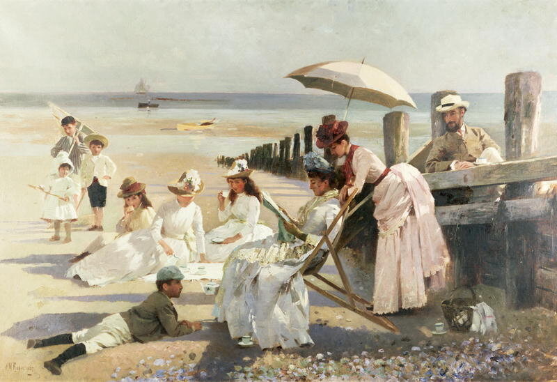
Say it's the mid-1800s, and you're on a beach in England. Things look pretty familiar: the wind tugs at parasols, children laugh and chase seagulls, the waves roll in and out. In the distance, though, an unusual figure straddles the water line, and stoops down over the sand. She's weighed down by enormous wool petticoats, and carrying a heavy bucket. From under her skirts peeks the unmistakable outline of a man's boot.
This woman isn't foraging for food, or trying to save a drowning child. She's one of Victorian Britain's many female seaweed hunters. Beloved by figures like Queen Victoria and George Eliot, seaweed-hunting became a popular way for women to tap into the enthusiasms of their era—and contribute to the burgeoning annals of science.
Nineteenth century Britain was a hotbed of biological enthusiasm. "Natural history was absolutely huge," says Dr. Stephen Hunt, a researcher in environmental humanities who works at the University of the West of England. Households filled up with painstakingly stuffed mammals and birds. So-called "gentlemen scientists" traveled the world drawing, describing, and collecting plants and animals. As railway networks grew, and labor advances led to more leisure time, ordinary citizens got in on the trend. Microscopes became more affordable, and collecting clubs popped up across Britain. "It was cross-class to some extent—working class and middle class," says Hunt. "There was a democratization of natural history."
Women, though, were still largely left out. The biggest natural history clubs of all, the Royal Society and the Linnaean Society, refused female members, and barred women even from their "public" meetings. Hunting animals was too dangerous, and digging up plants was, well, too sexy. "There was a taboo on botany, because Linnaean botany was based on the sexual parts," says Hunt. "That was seen as controversial."
Luckily, there was seaweed—docile, G-rated, and available somewhat close to home. "It was accessible for women in ways that other things weren't," says Hunt. As the seashore itself gained a reputation as a restorative landscape, plenty of women found themselves there, either recuperating from illness or seeking family-friendly summer fun. Many of them were already diehard scrapbookers, and seaweed makes a particularly rewarding collage subject: not only does each specimen's strange color and shape present a design challenge, its gelatinous inner structure means that, when pressed onto paper, it actually glues itself to the page.
While it's unclear exactly how many women spent their Saturdays kelp-crafting, there are enough amateur seaweed scrapbooks floating around to indicate that it was a popular pursuit. There is even one famous, long-lost scrapbook—Queen Victoria's, which she reportedly made as a young woman—and George Eliot has hinted that she dabbled, too, writing in an 1856 journal entry that the tide pools on the shores of Ilfracombe "made me quite in love with seaweeds." A number of collectors took their hobby to the next level, publishing descriptive guides complete with illustrations and collecting tips.
One of the best known and most dedicated of these so-called seaweeders was Margaret Gatty, a children's book author who took up the hobby while convalescing in Hastings, on Britain's southeast coast, in 1848. Gatty's crowning work of algology, British Sea-Weeds, is an exhaustive compilation of local seaweeds, fully described and illustrated in 86 colored plates.
But it's also a primer for women who might have been wondering how to align their exciting new hobby with the conventions of the time. In an opening section on how to dress, Gatty endorses a compromise between practicality and social acceptability. Wear your regular outdoor ensemble, petticoats and all, on top, she suggests—they are "necessary draperies." But definitely, definitely go for men's boots, and own it. "Feel all the luxury of not having to be afraid of your boots," she writes. "Feel all the comfort of walking steadily forward, the very strength of the soles making you tread firm."
Companionship was another issue. While women were given slightly more leeway at the shore than in the city, it was still seen as a dangerous place, full of slippery rocks and impending waves. "A low-water-mark expedition is more comfortably undertaken under the protection of a gentleman," Gatty wrote. How to convince one of them to go with you, rather than heading off on his own more risky or risqué natural history adventure? Offer up other enticements: "He may fossilize, or sketch, or even (if he will be savage and barbaric) shoot gulls," she recommends.
British Sea Weeds is an impressive work—two volumes, comprising 200 specimens, compiled over the course of 14 years. But like her female peers, Gatty made sure to position herself not as a scientist but as a kind of evangelist, interested in seaweed primarily as a low-level expression of nature's beauty and God's grace. "A lot of the women writers were sort of self-deprecating," says Hunt. "They very much saw themselves as popularizing natural history, but they took pains not to come across as professional scientists."
Gatty, who once wrote that hearing a woman give a speech was "like listening to bells rung backwards," planted herself firmly in her prescribed social role.
Privately, though, she found a certain escape in her hobby: "A love of routine makes in private life half the world commonplace and dull," she wrote to her sister-in-law, encouraging her to try out seaweeding. "Your seaweed hours will be a sort of necessary repast to you!"
For Gatty and others, the prioritization of religious rhapsody over rigor, combined with the heady freedom of the hunt, led to magnificent written reports—many of which remain more accessible than the dense taxonomies of their male peers. In British Sea-Weeds, one specimen is "delicately membranaceous," while another is "crisp and somewhat rigid when first gathered." Colors are lovingly described: "the finest crimson," "rose-red," "pinky towards the tips."
All fads eventually dry out, and as the Victorian era gave way to the modern one, fewer and fewer British women spent their spare time on the shore, feeling good in their galoshes and casting around for bits of red and green. Gatty herself never wavered in her enthusiasm, and kept collecting until her death in 1873. Although British Sea Weeds is now long out of print, her collections survive at St. Andrew's University in Scotland, where, over the past few years, curators have begun to restore and reorganize them.
Today's seaweeders would do well to look out for Gattya pinella: a species of Australian algae, named for one of the many woman who successfully found joy in seaweed.
Summer camp is a great American tradition. And one completely out of reach for the so-called “children of the night”—the name given to kids who are allergic to the sun.
This rare condition, xeroderma pigmentosum, makes summer camp, or any daytime outdoors activity, painful and even fatally dangerous. Luckily, there is a place that seeks to reclaim the tradition for children afflicted with XP: Camp Sundown. Opened in 1995, the camp is celebrating its 21st anniversary this year, as it continues to grow in attendance and in its efforts to bring attention to the condition.
Directed by Liza Mandelup, this video takes us into the world of Camp Sundown, where the hours are inverted and everyone comes out as soon as the sun is down. Located in Craryville, New York, it allows children to form a family with others who understand their condition. They swim, play around, watch movies, and roast marshmallows, all under the cover of the night.
Some of the camp counselors, themselves veterans of life with XP, give us an insight on what life is like for attendees. The message, it seems, is that while life is not easy, there's always a ray of moonlight to be found.
Every day we track down a Video Wonder: an audiovisual offering that delights, inspires, and entertains. Have you encountered a video we should feature? Email ella@atlasobscura.com.
In the early 1970s, a group of looters searching for Pre-Columbian artifacts in the jungles of Colombia’s Sierra Nevada de Santa Marta stumbled upon a set of worn stone steps leading up a ridge from the shore of the Buritaca river. At the end of more than 1,200 stairs, they found the ruins of an ancient, silent, abandoned city.
Shortly afterwards, a slew of exquisite artifacts began to flood Colombia’s black market, leaving archaeologists of the era puzzled as to the origins of such intricate golden figurines, urns, beads and statues.
Investigators soon caught on to the trail left by grave robbers. The region, which had been dubbed “Green Hell” by the looters, seemed impossibly difficult. Between the impenetrable tropical forest, the steep, treacherous gradations slicked by constant downpours, and clouds of disease-bearing mosquitoes, progress was slow. But by 1975, excavations were underway, and the site was shortly thereafter revealed to the world as Ciudad Perdida, or the “Lost City”.
What the archaeologists had uncovered was incredible, one of the most important archaeological discoveries of the century—a massive city, once home to some 2,000-8,000 inhabitants.
Perhaps most remarkable about Ciudad Perdida is the fact that it was built some 650 years before Machu Picchu, around 800 CE. Though only a small portion of the site has been excavated, the city is an impressive feat of engineering, built along a steep mountain ridge nearly a mile above sea level. A complex network of stone bridges and drainage systems has maintained the city throughout the test of time.
The site is believed to have been the seat of power of the Tairona kingdom, which spanned throughout the Sierra Nevada and the northern region of Colombia. A testament to the stability of the society that constructed it, the Lost City was constantly inhabited from its construction up until its abandonment, which likely took place in the 16th century amid the arrival of Spanish conquistadores. During this period of contact and conflict, portions of the Tairona people moved further into the reaches of the Sierra Nevada de Santa Marta, which allowed them to avoid the worst of Spanish colonialism of the 17th and 18th centuries.
Despite its name, the Lost City was never really lost, at least not to the descendants of the Tairona people who still occupy the region, today known as the Wiwa, Kogi, Arhuaco and Kankuamo. Though their ancestors abandoned the city centuries ago, the indigenous of the Sierra Nevada de Santa Marta never forgot about it. When the site was "discovered" in the '70s, indigenous leaders quietly asserted that they knew of the city’s existence all along. In fact, they had never stopped visiting the site, known to them as Teyuna, over the centuries. They simply had always been careful to keep its location a secret from outsiders in order to avoid precisely what happened after the looters found the city.
Today, after several years of closure in the early 2000s due to the kidnapping of foreign tourists visiting the Lost City during the height of Colombia’s armed conflict, the site is once again open to individuals interested in experiencing what can only be described as one of the greatest adventures in South America.
While Machu Picchu is accessible to just about anyone, only the most dedicated (and physically capable) of adventurers can visit the Lost City, which to this day is only accessible by a 27-mile hike through the same “Green Hell” experienced by those who uncovered the Sierra’s secrets.
The difficulty of the terrain is also part of what has provided protection to the descendants of the Tairona people, who believe the Sierra Nevada de Santa Marta to be the center of the universe, and consider themselves to be the “Elder Brothers,” responsible for non-Tairona people, the “Younger Brothers,” from destroying the equilibrium of the natural world. Despite thousands of years of constant occupation, the Sierra Nevada continues to be one of the most ecologically intact and biodiverse places on the planet, thanks to the resistance of indigenous groups to those wishing to intrude into the region.
I visited the Lost City with a guide from Wiwa Tours, one of the five tour operators that have permission to lead tourists to the Lost City, and the only one that is operated by the region’s original inhabitants. My guide, Miguel, though barely 16 years old, had the demeanor of a wise elderly man. He walked barefoot in a traditional white tunic, carrying only a small woven shoulder bag, and barely speaking a word over the four days that he led us through the forest.
Watching small groups of tourists flail along the muddied paths, disrupting the great silence of the forest, I asked Miguel why his people allow visitors to the site. He explained that he and his community want people to understand and respect the culture of the descendants of the Tairona, and the only way to do that is to allow people to experience it first-hand.
Visiting the Lost City on the heels of a person who is likely a great-great-great-great-great grandson of someone who inhabited the site before its abandonment drove home the cultural value of Teyuna. But it also raised the question of sustainability in an age where tourism is a viable economic alternative in a country once largely controlled by illegal armed groups and powered by coca cultivation. How the place will change over the years under the never-ending flow of tourists is anyone’s guess. What seems most important, however, aside from preventing the degradation of the region’s ecology, is respecting those who have preserved it up until now.
A version of this post originally appeared on Tedium, a twice-weekly newsletter that hunts for the end of the long tail.
They change the color of our skin. They get stuck in our teeth. But for some reason, we can’t stop eating cheese curls, the puffiest snack food ever created.
But these corn-and-powder snacks didn’t just fall like manna from the sky into our bowls, always there for us ahead of our Bojack Horseman marathon.
The story of the cheese curl is one of the more unusual creation stories in snack-food history, starting, of course, in Wisconsin, an agricultural hub that has given us a lot of food innovations over the years. (Three words: fried cheese curds.)
Some of these were intentional, others not, but the accident that made the cheese curl proved hugely fruitful for Flakall Corporation, a Beloit, Wisconsin animal feed manufacturer whose owners later switched gears to producing snack foods, all thanks to the way the company cleaned its machines. The company’s approach to producing animal feed was to put the material through a grinder, effectively flaking out the corn to get as much material as possible from the grain, as well as to ensure cows weren’t chewing any sharp kernels.
“This flaking of the feed is of advantage because it avoids loss of a good percentage of material which otherwise is thrown off as dust, and gives a material which keeps better in storage by reason of the voids left between the flakes, such that there can be proper aeration, not to mention the important fact that flaked feed is more palatable and easily digested by the animal,” the firm stated in a 1932 patent filing.
The grinder did its job, but it wasn’t perfect, and periodically required cleaning to ensure it wouldn’t clog. One strategy that Flakall workers used was to put moistened corn into the grinder. During this process, however, something unusual happened: the moist corn ran directly into the heat of the machine, and when it exited the grinder, it didn’t flake out anymore—it puffed up, like popcorn, except without the annoying kernels.
By complete accident, Flakall had invented the world’s first corn snack extruder.
Edward Wilson, an observant Flakall employee, saw these puffs come out of the machine, and decided to take those puffs home, season them up, and turn them into an edible snack for humans—a snack he called Korn Kurls.
You’re noshing, in other words, on repurposed animal feed.
This state of affairs led to the second patent in Flakall’s history, a 1939 filing titled “Process for preparing food products.” A key line from the patent:
The device preferably is designed so as to be self-heated by friction between the particles of the material and between the particles and the surfaces of contacting metal and to progressively build up pressure during the heating period. Thus the uncooked raw material, having a predetermined moisture content is processed into a somewhat viscous liquid having a temperature high enough to cook the mass and heat the water particles to a temperature high enough for evaporation at atmospheric pressure but being under sufficient pressure to prevent it.
If that’s a little complicated to understand, a 2012 clip from BBC’s Food Factory does the trick.
In the video, host Stefan Gates takes an extruder and connects it to a tractor, making the extruder move so fast that it puffs the corn out in an extremely fast, extremely dramatic way.
Clearly, Flakall had something big. The firm eventually changed its name to Adams Corporation, which helped take some attention off the fact that it was selling a food product to humans that was originally intended for cows.
Flakall wasn't the only early claimant to the cheese curl throne, however. In Louisiana, a firm called the Elmer Candy Corporation, developed a product eventually called Chee Wees, that they said was the actual first. And later the New York-based Old London Foods came out with its own popular variation, the Cheez Doodle, in the late 1950s.
But the most notable brand that still sells cheese curls wasn’t the first mover, just the one with the best marketing and distribution.
That would be, of course, Cheetos, which came about in 1948. While Cheetos came along later than its competitors, the Frito company’s variation quickly overtook the market, in part because Cheetos had gained national distribution due to the prior success of its namesake.
That company’s founder, Elmer Doolan, worked out a deal with H.W. Lay and Company to market Cheetos to the broader market. It quickly became a massive hit.
The success of Cheetos was so impressive that it played a large role in the merger of Frito with Lay in 1961, as well as the company’s later merger with PepsiCo just four years later.
And that success continues to the modern day. Cheetos are by far the most popular brand of cheese curls in the United States: According to Statista, the Cheetos brand had an estimated $969.5 million in sales in 2016, with the next most popular brand being Frito-Lay’s more-upscale Chester’s brand, which garnered up just 7 percent of Cheetos’ total sales.
These days, here are two main varieties of Cheetos—crunchy, the most common kind, and puffed, which only came about in 1971 or so. Each is made through different variations on the corn snack extruder process.
Yet despite the early success of the Cheeto, its mascot, Chester Cheetah, didn’t come about until well after the product’s launch.
These days, Chester Cheetah is trying to goad Beyoncé on Twitter just like every other advertising mascot worth its weight in salt, but there was a time that the cheetah was seen as so impressive that there was chatter it could become a cartoon lynchpin.
In fact, Frito-Lay got pretty far down the road with Fox in turning the mascot, launched in 1986, into a cartoon. Yo! It’s the Chester Cheetah Show, as the toon would have been called, was developed as a potential part of Fox’s Saturday morning cartoon slate. (CBS also considered making the show, but rejected it.)
Problem was, advocacy groups were not happy with the idea for the show, because of the fact that its roots were very clearly as advertising. Action for Children’s Television (ACT) and the Center for Science in the Public Interest (CSPI) were among the groups that petitioned the FCC regarding the program.
“His only previous television appearances, indeed his entire existence, have been in traditional commercial spots designed to sell a product,” the FCC petition stated, according to the New York Times.
ACT noted that it was rare to petition the FCC about a cartoon only in the planning stages, but felt it had to speak up due to what it felt was the unprecedented nature of the idea.
It didn’t help that Kraft was trying to sell Cheesasaurus Rex, its macaroni and cheese mascot, as a TV show around the same time.
Just a few weeks after the controversy blew up, Frito Lay and Fox shelved the idea, with Fox claiming that differences in creative control and long negotiations killed the show—not protests.
“I still believe he’s one of the best characters since Bugs Bunny, and the fact he is associated with a product was irrelevant to us,” Fox Kids President Margaret Loesch told the Times.
Frito Lay spokesman Tod MacKenzie, in comments to the Associated Press, was a bit more honest.
“Since Chester came out in 1986, he’s been wildly popular,” MacKenzie told the AP. “We don’t want to jeopardize the job he’s doing here.”
The book Saturday Morning Censors: Television Regulation Before the V-chip, published in 1998 by Duke University Press, pointed out that while ACT didn’t officially win the case with the FCC—which, during the Bush era, was in no mood to censor a show that wasn’t indecent—the group acted like it did, especially after its efforts also killed off the Cheesasaurus Rex show.
“We feel we have zapped, for the time being, the problem of logos turning into half-hour programs,” ACT President Peggy Charred stated at the end of the controversy.
But you still have to wonder what might have happened if the show got the green light after all this. (This wiki page certainly does.) Would we be eating fewer cheese curls? Maybe more?
Clearly, the cheese curl has come a long way from the days when it was a happy agricultural accident.
The company acquired Flakall’s successor company, Adams International, in 1993. It was an acquisition that makes a lot of sense. In the 1950s, Maddox Machine Shop worked directly with the Frito company to build the machinery used to produce the company’s snack foods, and it grew from there.
Every city has its own character and spirit. Among familiar towering skyscrapers and congested streets, there are unique layers folded in the fabric of urban environments. These nuances are what Sohei Nishino captures in his massive monochromatic map series Diorama Maps.
For the past 14 years, the 34-year-old photographer and artist has wandered up and down streets, alleyways, mountain tops, and monuments snapping thousands of photos of major cities around the world. He’ll spend anywhere from one to three months taking pictures with his 35mm Canon EOS 1V before he returns to his studio in Shizuoka, Japan and begins the long, arduous process of piecing together the tiny contact sheet prints on a large canvas.
The maps are like panoramic puzzles. The thousands of different black and white photos taken over months of walking through a city are layered in a chaotic, yet beautiful collage. Each of the photos build a part of the city—the streets, rivers, skyscrapers. So far, Nishino has captured the architecture, culture, energy, people, and day-to-day life of 20 cities.
From a distance, the steel gray abstract maps appear messy, whimsical, and almost illustrated. But, upon closer examination, intimate scenes unfold. You can gaze at individual photos of pedestrians crossing a street in Osaka, a bird soaring around the Oude Kerk bell tower in Amsterdam, a couple sitting on a doorstep in Havana.
“For me, assembling the images is the process of reconstructing my memory of the journey and seeing it from an overall view,” says Nishino. “In a sense, Diorama Map is like a tapestry which was weaved by thousands of threads of my months journeying through cities.”
When attending Osaka University of the Arts, Nishino would search for secluded, high places where he could observe the city and regain mental balance, he says. Gradually, he began to take photographs of his path, and make contact prints—a sheet of small-format film strips typically intended to review a series of images.
Nishino pasted the prints to postcards that, when assembled, revealed a map of his journey. He continued to piece together more areas of the city until he completed his first diorama map of Osaka.
For Nishino “the act of walking is very close to meditation.” For every diorama map, he’ll start by trekking around the city by foot. When he first began the series, he only took photographs from a birds-eye-view, climbing up monuments like the Hagia Sophia mosque in Istanbul, Turkey.
While he reveled in the breathtaking views from above, Nishino realized that the overlooked, ordinary scenes of everyday life of the locals were just as beautiful. In his recent maps, he experiments with more complex angles throughout a city, including photos taken from underground, a canoe sailing on a river, and between narrow streets.
“It gives more depth and reality, and captures the characteristic of the city,” he says.
After shooting, Nishino returns to his studio, develops the film, makes contact sheets in the darkroom on photographic paper, and then cuts out all the tiny contact sheet photos to make one large single shot. Each of the small photographs are placed onto a large white board in which he will sketch out a template of the map of the city—a tricky process since he uses almost all the photos he takes.
By the end of months of shooting, Nishino will have thousands of photos (his latest map of San Francisco contains about 2,000 photos). He divides all the photographs by area to make it clear where they were taken, he says. After creating the tiled collage, he reshoots the map with a digital camera and prints it on photographic paper.
The result is not your traditional map, but a look at a city from an individual’s view point. “Maps existed not only for showing us correct geographical information like Google maps, but they also existed for our personal memory and sense of time,” he says.
Even though the layered, collage effect blurs the urban environment, there are distinguishable features that make it easy to identify the city. For instance, you can make out the edges of the island of Manhattan and see the winding river Thames in London.
Since the maps are also devoid of color, the viewer is forced to recognize the objects within the maps, Nishino says. However, it doesn’t prevent the cities from emitting vibrancy. Nishino adds individual flare to each map: shades of color can be seen in the carnival scene in Bern, and you may be able to spot the portraits of his friends in the map of New Delhi. Nishino encourages people to use his maps to get lost in cities.
“Before [Diorama Maps], I used to see the city as a mass of solid architecture,” Nishino says. “Now, I see the city more as an organic lifeform that has personality. I realize that how I experience and walk in the city does change my attitude towards the city itself.”
Watch a time lapse of Nishino piece together his latest map of San Francisco:
A disc of light moves across the cathedral floor. The marble in its path lights up, revealing deeply colored swirls, rich with hues of burgundy, plum, caramel, and ochre. It is ancient rock, stained by terrestrial chemistry and by the infernal pressures of the inner Earth. Its surface is smooth and nearly reflective, testament to extraordinary craftsmanship but also to the effects of hundreds of years’ worth of penitent feet processing through the looming shadows of the church interior. The air smells of smoke and candle wax, and the occasional perfume of a passing tourist.
The source of this light is a hole punched through the roof of the church high above, elaborately accentuated by a brilliant halo of golden rays, painted to resemble the sun. The hole acts like a film projector. Daylight streams through, creating a narrow beam of illumination visible only in the presence of smoke or dust, as if something otherworldly has been forced into material form.
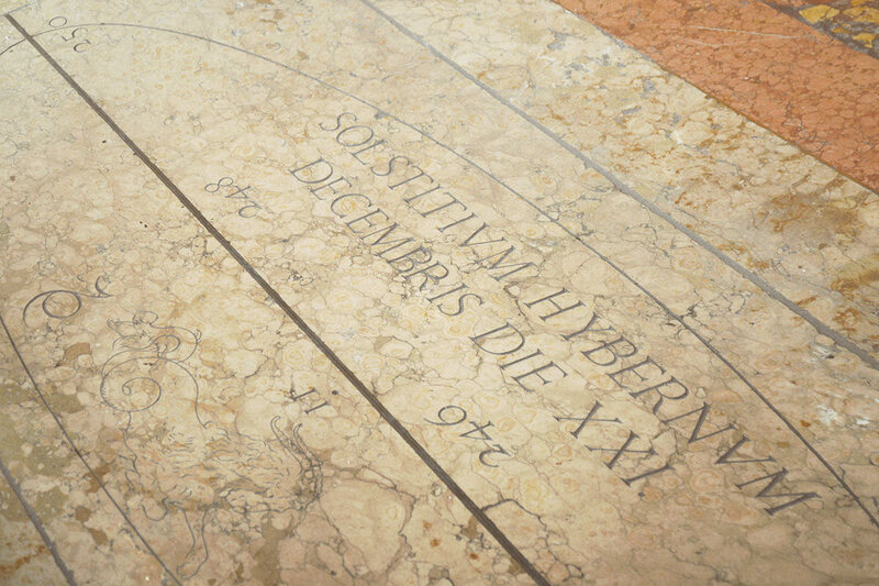
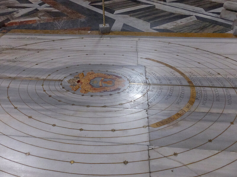
Seconds pass, minutes, an hour. Outside, the sun appears to arc slowly across the daytime sky; here, in response, the projected disc creeps inch by inch across the marble floor. At solar noon, when the sun has reached its highest point in the sky, the circle of light touches a long, straight line made of inlaid brass and copper, nearly 220 feet from end to end, or two-thirds the length of an American football field. Although this line extends more than half the length of the cathedral floor, it seems to follow its own geometric logic: it is a long diagonal slash cutting between two columns, against the building’s floor plan, as if at odds with the structure that houses it.
Stranger still, on either side of this brass line, words and celestial images have been carved directly into the rock. There are the 12 signs of the zodiac interspersed amongst Roman numerals and references to solstices. There is Aquarius, the water bearer; Capricorn, with its confusing mix of shaggy horns and the coiled tail of a sea creature; Sagittarius, preparing to fire a magnificent bow and arrow; and the pouting fish of Pisces. At first glance, these symbols seem pagan, even sacrilegious, as if the astral remnants of an older belief system have somehow survived beneath the feet—and beyond the gaze—of daily worshippers.
Yet these symbols are not there to cast horoscopes, let alone spells. They are there for purposes of church administration and astronomical science. This cathedral, the Basilica di San Petronio in Bologna, Italy, also doubles as a solar observatory—at one point, one of the most accurate in the world—and these signs of the zodiac are part of an instrument for measuring solstices.
“I can say that I literally tripped over the subject,” science historian John L. Heilbron explains to me. Heilbron is emeritus professor of history at the University of California, Berkeley, as well as the holder of advanced degrees in both history and physics. Born on St. Patrick’s Day in 1934, he continues to lecture on topics ranging from “vortex rings” to the epistemology of Niels Bohr. In addition to a biography of astronomer Galileo Galilei, he is author of an excellent book called The Sun in the Church: Cathedrals as Solar Observatories, a study of what are known as “meridian lines.”
When we speak, Heilbron is spending a long weekend in Joshua Tree National Park. He is an avuncular presence over the phone line, revisiting points he had published two decades earlier as if he had written them yesterday.
“I wondered what this brass line was doing there in the floor, encased in marble,” he continues, “with all these numbers running up and down it, inside a Catholic church. I decided to look into it. It was really that simple.”
“The lesson, though,” he laughs, “is that when you’re inside a church you should look down as well as up.”
Heilbron’s book, published in 1999 by Harvard University Press, was the first major English-language study to take this advice seriously, exploring the origins, meaning, and transformation of these early astronomical instruments hidden in plain sight, disguised in the very architecture of European cathedrals. Bologna’s Basilica of San Petronio is not the only example of a meridian line, although it was considered to be the most accurate. Santa Maria degli Angeli in Rome has a beautifully realized and particularly grandiose example cutting through its nave; Saint-Sulpice in Paris hosts its own, as does Santa Maria del Fiore in Florence; a church tightly nestled in the packed streets of Fossombrone, Italy, bears a meridian line; the heavily worn remains of a line are still visible in the cloisters of England’s Durham Cathedral; and the duomos of Milan and Palermo also contain their own meridian lines.
In the process of researching the phenomenon, Heilbron uncovered a surprising story of cooperation not only between religion and science, but between precision astronomical observation and Catholic liturgy, between architectural design and the Christian calendar. Direct, even enthusiastic collaboration, uniting esoteric science with canonical religious belief, lay at the core of this hidden story.
The very fact that there is a longstanding connection between astronomical observation and the Catholic Church would surprise many modern readers. If anything, the relationship between these institutions—that is, between the altar and the telescope, the cathedral and the meridian line—would appear to be antagonistic, even contradictory. After all, the Church rather infamously persecuted Galileo in the 17th century for suggesting that the Earth is not, in fact, at the center of the cosmos, and that, by extension, Church doctrine relating to God’s orderly plans for the world were inherently flawed. Galileo’s rejection as a heretic has become emblematic of the popular belief that there is an abyss separating religious faith from rational scientific inquiry.
This was not always the case, however. As Heilbron points out in his book, the Catholic Church supported astronomy for more than six centuries, from medieval times to the Enlightenment. This sponsorship continues into the 21st century, as we’ll see—although the meridian lines themselves had another, less lofty purpose entirely.
Easter, a Christian holiday commemorating Jesus Christ’s resurrection from the dead, is defined not only by Church liturgy but also by astronomical circumstance. As specified by the First Council of Nicaea, Easter is not a straightforward anniversary, always recurring on the same date from now until eternity. Instead, it is to be celebrated on the first Sunday after the first full moon after the spring equinox—an occasion already laden with astronomical significance. The equinox, after all, is a day when time is split equally into 12 hours each of light and darkness, of illumination and obscurity.
The stakes of getting the date right were unusually high, Heilbron writes. If the faithful were to worship Easter on the wrong Sunday, out of sync with the rest of Christendom, then their very souls could be at risk. This was not merely an academic concern: at the height of the Church’s calendar problem, in the second half of the 16th century, the eastern Church and the western Church were an incredible ten days out of sync with one another. This was only reconciled in 1582 when Pope Gregory XIII implemented what has become known as the Gregorian calendar reform.
Gregorian reform eliminated, at a stroke and literally overnight, ten entire days from the western European calendar. People going to bed on October 4th, 1582, when the reform was implemented, would have woken up the next morning to find it was October 15th. Although this disorienting reform was intended specifically to put the calendar back on track for reaching the next spring equinox on March 21st, March 21st is not always the true, astronomical spring equinox. To determine exactly when the equinox would be, in the future—and, thus, when Easter should properly be celebrated—a more subtle and astronomically precise tool of measurement was required. A meridian line.
Understanding the structure and rhythm of the cosmos through direct scientific observation was thus not antagonistic to Christian worship at all. It was an essential expression of human piety: an earnest attempt to synchronize human religious activity with the divine and invisible clockwork of the universe. And thanks to this vast astronomical device embedded in the floor of a cathedral, Easter could now be determined not just with a quick glance, but with unquestionable precision.
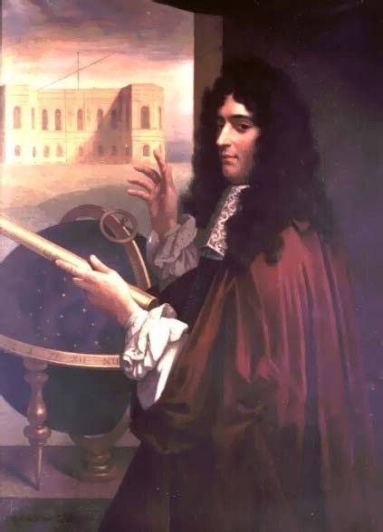
The first meridian line at Bologna was installed by an artisan and Dominican cartographer named Egnazio Danti in 1575; when the church was enlarged many years later, in 1653, however, a wall central to Danti’s instrument was displaced, fatally undermining its intended function. Almost immediately, Jesuit astronomer and engineer Giovanni Domenico Cassini was brought in to repair, extend, and substantially improve upon Danti’s work. Cassini later became director of the renowned Paris Observatory and shares credit for discovering Jupiter’s famous “red spot.” More recently, his name was borrowed for a high-profile NASA satellite mission launched in October 1997 to photograph the moons of Saturn.
Here on Earth, in 1655, Cassini began work on the meridian line that we still see today in Bologna. With the exception of repairs performed in 1695 and again in 1776, the device remains true to Cassini’s 17th-century design.
The Basilica di San Petronio tries to make the most of its meridian line. Although the line itself is now roped off and partially encased in plexiglass, these barriers have the effect of drawing even more attention to this strange diagonal slash across the marble. A small explanatory pamphlet is offered for sale near the cathedral entrance. Written by Giovanni Paltrinieri, a local historian, it comes in multiple languages; the English version was translated by none other than historian John L. Heilbron.
If it still seems surprising that a cathedral would house an astronomical instrument, consider the unusual spatial circumstances such a device would require. You need a large, flat surface on which a meridian line can be drawn. You need an open volume of unobstructed space through which a precise beam of sunlight can shine. You need a hole in a ceiling high enough so that this beam can track hundreds of feet, from one solstice to the next and back again. “The most convenient such buildings were cathedrals,” Heilbron writes.
The way meridian lines operate is both surprisingly complex and quite easy to grasp. As the sun tracks from north to south on its annual migration between the summer and winter solstices, its image on the cathedral floor also shifts, moving slowly along the meridian line. Halfway between the solstices, of course, are the spring and autumn equinoxes. Once the position of the solar circle indicates the spring equinox, believers must simply wait for the next full moon; the first Sunday after that full moon will be the proper date of Easter.
So far, so good. Constructing a well-functioning meridian was no simple matter, on the other hand, and there were many ways it could go wrong. In order to support those cavernous church interiors, for example, huge columns are required; those columns are large and orderly placed, but they also invariably complicate the possibility of placing a straight line uninterrupted across the cathedral floor. In Bologna, for example, the meridian line butts up against—and is partially absorbed by—a column. Other architectural details, such as cornices, can also get in the way, blocking the beams of sunlight so essential to the meridian’s function. Heilbron points out, for example, that, in Rome’s Santa Maria degli Angeli, an architrave—or door lintel—had to be partially removed to ensure that sunlight could reach the meridian line.
This vision—of selectively dismantling the interiors of European cathedrals, one architrave at a time, in order to transform them into finely tuned scientific observatories—is extraordinary, as if, beneath all the masonry and ritual, with just a slight movement of specific details, powerful astronomical tools lie hidden. Beneath the pulpit, a planetarium.
From the point of view of Church doctrine, however, a larger problem was beginning to emerge. Perhaps these instruments were too precise. The observations they enabled began to reveal evidence not that the Earth was stationary, pinned at the center of Creation, but, on the contrary, that the Earth was mobile, circling in a dizzying choreography around the sun. The cosmic model endorsed by the Church was wrong, in other words, and proof of this wrongness was revealed every season by instruments built into the very floors of some of Europe’s finest cathedrals.
Well within sight of the church pews, a moving beam of sunlight suggested that the cosmos was altogether stranger than Christian theology had allowed itself to imagine. In Heilbron’s words, Catholic officials had not expected “that their cathedral would provide information about the heavens opposed to the teachings of their church.”
Paul Mueller is a member of the Society of Jesus and administrative vice director of the Vatican Observatory. Raised in the American Midwest, he became a Jesuit after receiving a Bachelor of Science in physics from Boston University. From there, Mueller went on to an intimidating succession of advanced degrees in philosophy, divinity, sacred theology, and physics. He currently splits the year between the papal complex at Castel Gandolfo outside Rome and the Vatican Observatory in Arizona.
The Church, after all, is still actively engaged with astronomical research. Its sponsorship did not end with meridian lines, but has continued well into the 21st century with, among other things, the Vatican Observatory’s high-tech facility located in the remote darkness of Mount Graham, near Tucson. There, a dedicated team of Catholic astronomers—studying such topics as stellar evolution, the atmospheres of exoplanets, and processes of galactic formation—operates the Vatican Advanced Technology Telescope, or VATT, to watch the desert skies. Yet another unexpected juxtaposition of empiricism and faith will take place next spring, in May 2017, when the Observatory hosts an international workshop on “spacetime singularities” and gravitational waves at Castel Gandolfo, the Vatican compound on Lake Albano, the flooded crater of an extinct volcano southeast of Rome.
There is much less of a conflict than it might seem between advanced astronomical observation and Christian faith, Mueller explains to me, let alone between a basic measuring tool like a meridian line and Christian doctrine. In conversation, Mueller is precise and patient—but also slightly prickly. He does, after all, occupy an unenviable position of being attacked from both sides: by believers unsure of why he and his fellow brother-astronomers feel compelled to pry at the edges of the known universe, as if kicking the tires of Creation, and by secular physicists who seem all to eager to dismiss Vatican astronomy as hopelessly clouded by medieval superstition.
But, Mueller emphasizes, reason is crucial to religious practice. “If we are doing math, if we are doing science—for that matter, if we are doing art—any human activity done with generosity and reverence is acting in God’s image. Science is included in that.”
Contemplating the origins of the universe or measuring the obliquity of the Earth’s angular relationship to the sun is not in opposition to Christian faith at all, he stresses, no matter what those observations might reveal. Faith, in fact, he suggests, is precisely pinned on the confidence that religious doctrine and apparently contradictory scientific data will eventually be reconciled. There is no reason to dismiss or otherwise shy away from theologically uncomfortable scientific results, including previously controversial ideas, such as evolution and climate change, both of which Pope Francis has now urged Catholics to accept.
Whether the Church in Galileo’s time would have agreed with Mueller’s generous assessment is perhaps made clear by the astronomer’s cruel fate. Galileo, of course, was accused of heresy for promoting a heliocentric solar system (not to mention, as Heilbron writes in his biography of Galileo, for his arrogance). It was not until 1992, 359 years after his death, that Galileo was finally cleared of these charges—although the Church had quietly lifted its ban on Galileo’s heliocentric astronomy in 1757.
Mueller, however, also cautions me against over-emphasizing the role of meridian lines in Church affairs, in particular with determining the date of Easter. Of course, those lines would have been used to confirm the date of this major holiday, he says; after all, they were ingenious instruments of solar measurement. But remember, Mueller adds, the major Gregorian calendar reform took place in 1582—more than half a century before the era of meridian lines truly began and nearly 75 years before Cassini began his work in Bologna.
“My point is, sure, you can use a meridian line to help you with Easter,” Mueller tells me, “but that really happened after the fact—the calendar was already reformed by that time.” For Mueller, the meridian lines were simply testaments to the success of Gregorian calendar reform, given pride of place inside grand cathedrals “almost as a celebration of the fact that astronomy was used to fix the date of Easter, and in support of the Church’s new engagement with astronomy.” They were evidence of worshipful exactitude in celebrating the anniversary of Christ’s resurrection.
Alas, by the middle of the 18th century, at the very height of the meridians’ instrumental power—after lines throughout Europe had been reworked, renovated, and fine-tuned over many generations to be more accurate instruments than ever before—they were superseded for the complex work of solar observation. Meridian lines had been made obsolete by ever larger and more powerful telescopes, and by the use of precision-ground glass lenses.
The meridians’ usefulness did not disappear entirely, on the other hand; the lines were simply demoted. Formerly relied upon for measuring solstices, revealing unexpected angular details about the Earth’s relationship with the sun, and marking the date of Christ’s Resurrection, they were now used to determine local noontime.
If you return to the church of San Petronio just before solar noon—which is different than the abstract noon indicated by your wristwatch or smartphone—you will see that the disc of pale light on the floor is shifting horizontally toward the meridian line. At the actual moment of solar noon, when the sun is highest in the sky, the beam of light will touch the line itself, passing across it as morning becomes afternoon.
The meridian thus also acts like a daily clock—and, following their redundancy at the hands of powerful telescopes, meridian lines did indeed find a new role as a tool used to synchronize church bells. Heilbron refers to this as battling “the inconvenience of multiple noons,” an embarrassing problem where churches might ring out competing middays, sometimes several minutes apart, betraying the fact that the seemingly well-organized temporal structure of Christian civilization was in a state of minor disarray.
To a certain extent, this quotidian fate was built into the meridians’ very workings. As Heilbron points out, many of the craftsmen hired to work on the lines had been trained as clockmakers. Their skills in metalwork and precision instrumentation had prepared them well for work at an architectural scale.
Today, in an era of atomic clocks, smartphones, and digital timekeeping, however, meridian lines are not even useful for that. Now reduced to mere tourist attractions—and often overlooked entirely by visitors paying more attention to the frescoes, arches, and stained-glass windows—meridian lines nonetheless still function. They still silently mark the passage of time and the Earth’s movement around the sun, highlighting solstices and equinoxes as the rhythmic clockwork of the universe continues its restless motion.
Stranger yet, however, is the fact that these instruments are not, in fact, stationary. The churches, bulwarks of eternity, move. Little by little, decade after decade, these mountains of masonry are sinking, unsteadily settling into the soil, throwing off the angle of the sun and introducing a new source of inaccuracy into the resulting measurements.
This is true to the extent that the meridian line installed inside architect Filippo Brunelleschi’s Cathedral of Santa Maria del Fiore in Florence eventually became used as nothing more than a diagnostic tool for determining how much the cathedral itself had shifted. No longer useful for astronomical observation at all, the meridian became something more like an emergency light on the building’s creaking dashboard.
Even in Bologna, however, the church of San Petronio was moving downward. Heilbron explains that the hole punched through the cathedral ceiling, through which daily beams of sunlight blazed, “had fallen over 4 percent of its original height”—and this was in the late 1600s. It was only by comparing solstice measurements taken from San Petronio with other church meridians that the deformation was detected. Arguments over exactly how far the hole had shifted—with some people claiming only 1 percent, not 4—meant that “a battle ensued among the mathematicians of Bologna,” Heilbron writes. They soon descended into arguments over how their models of the cosmos had been distorted not by the Church but by the actual church: the building itself, that is, not the religious institution that funded their astral research.
Later, solutions to the problem of mobile architecture were proposed. These included attaching plaques to internal pillars that were structurally unconnected to the walls of the church. This meant that the plaques would not settle with the rest of the building and could thus be used as what Heilbron calls “a fiducial mark” for checking future measurements. Other approaches suggested using independently suspended floors so that, as the church changed position over time, the scientific instrument at its heart would remain untouched.
In a sense, Mueller’s point that the Church is now fully supportive of contemporary astronomical research is strangely borne out by this architectural detail. As these older buildings unevenly sink into the ground or become treated merely as sites for curious tourists, the real work of engaging with the cosmos has simply changed venue. The lines, however, remain, serving both as scars left by those unfortunate wars within the Church to separate faith and physics, and as seams that were able to bridge that gap.
Update 11/15: An earlier version of this story incorrectly stated that Galileo was executed for his beliefs. He was persecuted by the Catholic church, and forced to recant his views, but died naturally during his eight-year-long house arrest.
Paul Mueller is the administrative vice director of the Vatican Observatory, not an astronomer there.
As a visitor to Havana, Cuba, it's easy to feel like you're missing something. Since the revolution in 1959, Cubans have found ways to get what they want, even if buying a house once meant getting a sham marriage to the previous owner or eating well meant buying food on the black market. For every official system, it can seem like there's another, less official way of getting by, working just out of sight.
But some of Havana's secrets are easier to decipher. Most places have codes, and as a visitor it can feel like they’re secrets to be unlocked. Here's a quick key that'll help decode some of the basics.
There are two official currencies.
Cuba has two currencies, the Cuban peso, or CUP, and the convertible peso, or CUC. Most Cubans get their salaries in CUP; foreigners uses CUCs. The bills are the same size, but there’s an easy way to tell them apart. CUP feature the faces of national heroes; CUCs feature monuments.
There’s a symbolic connection between CUPs and CUCs, though: the same denomination will honor the same hero in both currencies. So, for example, a 5 CUP bill has a bust of Antonio Maceo, second-in-command during the Cuban revolution, and the 5 CUC bill shows the Havana monument built in his honor.
No one calls Avenida Salvador Allende by its official name.
Originally, this street, the first connecting old Havana to the stately Vedado neighborhood, was named after the Spanish king Charles III—and among locals, it's still known by its old name, Avenida de Carlos III.
Before you can hail a collective taxi, you have to know where you're going.
To avoid the overcrowded buses, many people use “taxis collectivos”—old cars that run regular routes along the city's major thoroughfares. Not all the taxis on a particular street are going the same way, though, and they will only stop to pick up passengers that are going in the same direction the driver's headed. Riders can indicate which route they want with hand signals. For instance, if you're on the east side of Avinida Rancho Boyeres, you can signal that you're headed to Vedado...
...Old Havana...
….Carlos III...
...or straight ahead.
Many of the cars belong to the government.
All-gray license plates with numbers starting with P are privately owned. A blue strip on the left-hand side of the license plate indicates it’s a government car—and more likely to be made after 1959 and imported from China.
Since 2014, the government has been selling imported cars, but at an incredible mark-up. Before that, the only way for a private person to buy a car was to get a letter of permission from the government, which, on the secondary, underground market, were worth about $2,000.
Uniforms are color-coded.
Elementary school kids wear red shorts; middle school students wear mustard-brown pants and skirts; pre-college students wear dark blue bottoms and light blue tops. If you see groups of young people wearing sharp white shirts and black bottoms, they're likely studying to go into the tourism industry.
Teenagers also color-code themselves.
Havana teenagers who are passionate about pop identify as mikis (after Mickey Mouse), and girls in this group often wear tight, bright pink outfits or dye their hair the same shade. Emo kids wear black, as do friki teengagers, who spike their hair and wear tattoos.
A cute little park can mean a building didn't make it.
Many of Havana's buildings are in bad shape, but even after the Office of the Historian of Havana designates a building for restoration, families can choose to stay or to move out. Often they stay, because there's a real risk the renovated building will house fewer families and not all of the previous residents will be able to return. Because of these and other delays, some buildings can't be saved, and after they're torn down, the city will turn the empty lot into a pocket park.
If you see this sign on a house, you might be able to stay there.
Casas particulares are private homes that pay a fee to the government in order to operate as guest houses.
A white bust of a man’s head means you’re outside a school or other government building.
It’s Jose Marti, another hero of the Cuban Revolution. There’s also a giant statue of him in the Plaza de la Revolucíon.
The numbered stones low to the ground aren’t a secret code.
In western Alaska, a man from Unalakleet came across these two unfortunate moose frozen into the river. Their antlers are locked together: they were fighting when they died.
Perhaps they drowned and were frozen later; perhaps they were so distracted by their battle that they didn't notice the cold creeping up on them. Either way, when the river froze, they were still locked together.
“It appears that one of the brow tines (on the antler) penetrated and may have ended this (battle) fast, leaving the ‘winner’ with a 1000 lb headdress and probably pulled his head into the water where he drowned,” Jeff Erickson, who helped recover the moose, told Craig Medred, an independent journalist in Alaska.
On Friday, January 20, 2017, Donald J. Trump will be sworn into office as the President of the United States of America. In an earlier age, we would have been blessed with over an extra month of Obama. For better or worse.
Incoming presidents have been being sworn in on January 20 since 1936, usually in a massive ceremony, full of all the pomp and circumstance befitting the introduction of a world leader—unless the 20th falls on a Sunday, in which case they are sworn in privately, and the party is held on the following Monday). But this wasn’t always the case.
The original day of inauguration for both Presidents and Vice Presidents used to be March 4, but the date was pushed up to January with the passing of the 20th Amendment to the Constitution. With the exception of George Washington himself, who was sworn in on April 30, 1789, each of America’s leadership teams took office on March 4, or publicly on the 5th, observing the Sunday rule we still abide by today.
This gap between election and formal taking of office was initially put in place for a few reasons. For one, as the Constitutional Accountability Center pointed out in a post from 2009, collecting and tallying the vote used to take a great deal longer than it does today, with numbers having to be carried across the country via horse and buggy. Not to mention the time it took for a president-elect to relocate to the White House. The other reason for the delay, and the reason there remains a gap of a few months to this day, is that there a number of things that an incoming president needs to figure out, like cabinet positions, while the outgoing president needs to spend that time easing the transition and protecting their legacy.
However, when the transition time lasted four months, it created a number of problems. Probably the most glaring example of the bad things that can happen by leaving a “lame duck” president in office for too long is what has come to be known as the “Secession Winter.” During the long wait between the election that put President Abraham Lincoln in office and when he finally took office, Southern secessionists were able to seize federal arms and defenses and establish the Confederate States of America, kicking off the Civil War. Neither the sitting president, nor the president-elect seemed able to impede the separatists, and by April of 1861, the country was at war. This has often been attributed to the long lame duck period.
Surprisingly, the four-month gap remained in place well after the Civil War and into the 20th century. The downsides of the extended wait time would become apparent again in the 1930s after Democratic President Franklin Roosevelt defeated Republican President Herbert Hoover. During the uncertain time between their terms (from November 1932 to March 1933), The Great Depression was in full swing, and their inability of the two leaders to enact lasting economic reform worsened the trouble. However, even as this problematic gap was under way, action was being taken to shorten the lame duck period.
The 20th Amendment, which has been nicknamed “The Lame Duck Amendment,” was ratified in January of 1933. Among other things, this amendment shortened the time that politicians in both the Congress and the Presidency could remain in office after an election. The inauguration day for the president was moved to January 20, while the start date for Congress was bumped up even further to January 4. This two-week difference between the inauguration of new members of Congress and the incoming president was established to give Congress time to respond to a situation in which the regular voting process was unable to determine a president-elect, the candidate died, or some other scenario where there was no president to be sworn in.
Ever since, January 20 has become a day of either celebration or despair, depending on your political views. But no matter how you feel about the president being sworn in, at least you can be certain of when it will happen.
Government agencies are not renowned for their soulfulness. Hidden beneath opaque acronyms—DOL, PBGC, OSHRC, FMSHRC—the only hint of color these monolithic administrative bodies tend to display is the bureaucratic red tape that binds them.
But in a sea of otherwise dehumanized agencies one has set itself apart. The Federal Aviation Administration, better known as the FAA, regulates all aspects of civil aviation—airports, air traffic controllers, even commercial space vehicles. But where it differs from the rest of the acronymic morass is that it is the only government agency to have its own theme song.
“We're forty-some thousand strong, Working together as we sing this song. We are the people who can do the job when it’s on the line. We always know just what it takes, every hour of every day, to keep you flying safe across this land and around the world.”
So goes the first verse of the FAA Theme Song, also known by the alternative title, “The People of the FAA.” It’s a catchy ditty, a Sly and the Family Stone-esque tune that sounds as if it had drifted in from a 1960s variety show, having stopped off via Sesame Street along the way. It actually stems from the 1980s, when John Hanks, a former Public Affairs Director of the FAA, decided his agency needed a lift.
Hanks was renowned around the agency’s Washington offices for dressing up as Elvis Presley and performing at annual jamborees. It was while trying to drum up support for a savings bond drive that he first stumbled on the idea of forming a group made up of FAA employees. After posting ads in the FAA newsletter and around the agency’s headquarters, Hanks pulled together an all-female group of 10 employees to perform a thematically appropriate composition entitled “Bonds Will Keep You Together”.
In the only extant video of this song, the group—which became known as the FAA Chorale—can be seen shimmying and singing while wearing matching flight attendant uniforms of blue suits, white tops, and red scarves. For a few brief minutes they provided an alternative reality to government drabness, performing at bond drives year after year, not just at the FAA but across other agencies too.
Enthused by how well the FAA employees performed together, Hanks began working on his magnum opus as the 1980s drew to a close. “I am a child of the ‘60s pop culture,” Hanks says of his influences. Inspired by the dense “Wall of Sound” productions of producer Phil Spector, he composed a song that was both salutation and exultation.
“It was designed to bring the FAA employees closer together in the common purpose we had in our mission of aviation safety,” he notes.
This may seem a tall order, but it was not one that Hanks shied away from, confronting the agency’s mission head-on with verses such as:
“We're planning and building a way to make tomorrow even safer than today. While flying grows, so do we and that's what it’s all about. We want to help you get back home in a jumbo jet or flying alone. We make it safe up in the sky so you'll relax when you fly.”
The song was a huge success. “The employees loved it,” recalls Hanks, and even the FAA’s administrator—a distant figure in the agency—wrote to Hanks to thank him. The FAA Chorale went on to perform at numerous events across the country, including at one of Nancy Reagan’s “Just Say No” anti-drug rallies, following the headliner, Latoya Jackson, onstage.
There was really no precedent for such an anthem. While songbirds in the military have crafted dozens of themes and songs, organizational anthems within civilian agencies is much rarer. Indeed, such songs in praise of organizational acuity are much more common within private industry. Corporations once sponsored traveling musical revues—with budgets that often surpassed Broadway shows—to tout their products. (At American Standard Company’s The Bathrooms Are Coming show from 1969, songs like the delicate ballad “My Bathroom” were first, and last, sung.)
By the 1980s, though, corporate anthems had become more closely associated with Japanese firms, where they were sung to reinforce company spirit and improve overall morale, often being performed alongside morning exercises. The FAA is unique in being the only government agency to blow its own horn, literally.
While the song’s appearance on YouTube has seen ungenerous commenters associating it with a misuse of governmental funds, these criticisms are misplaced. The song cost nothing to the taxpayer except the time, effort, and enthusiasm of Hanks and his musicians. You may think the tune is cheesy, the singers a tad off-key, but perhaps if the DHS, EPA or even FBI had anthems of their own, that showed the rest of the country they were normal people doing normal things, the popular antipathy towards government might be ever-so slightly lessened.
Thanks to John Hanks and the Chorale, the FAA became, for a short while, just a bit more human.
Creating the world in miniature isn’t easy. The detailed craftsmanship of globe making has been refined over centuries—requiring multiple steps and often multiple artists. In the 1955 video above archived by British Pathé, the skilled globe makers at an unspecified North London firm of geographers take viewers through the fascinating process step-by-step.
The globe makers start by applying thick, brown strips of paper around a wooden ball to create the shell, which is then coated in nine layers of plaster. At the 52-second mark, you can see the globe maker slather fistfuls of the wet plaster over the shell, spinning the sphere so the surface comes out smooth and creamy. This step alone takes about six hours, the narrator explains.
Then the globe gets its geography, which is “like restoring the skin to a peeled orange.” It’s an important step that can significantly affect the end product if there’s an error.
“The covering process calls for a keen eye and a steady hand,” the narrator says. “A fraction of an inch out will put the world miles out of joint.”
Every day we track down a Video Wonder: an audiovisual offering that delights, inspires, and entertains. Have you encountered a video we should feature? Email ella@atlasobscura.com.
If you tried to rob a bank in England in the 1940s, your efforts may have been thwarted by a gramophone. Or, more precisely, a gramophone burglar alarm.
The possibility of setting off an electric alarm had never been an option until 1858, when the first such device was installed in 1858 in Boston. Similar gadgets quickly became popular in stores, banks, and even the private homes of the wealthy. Over the years, many forms of burglar alarms appeared, each new one trying to better the faults of its predecessors. However, there is no alarm, past or present, that is as visually intriguing as the gramophone burglar alarm.
This device was designed exactly like a gramophone, with a small turntable record that played as soon as the needle scratched it. Only instead of playing the fine tunes of the jazz age, you got an unnerving alert message letting the listener know that a premises were under attack.
Its mechanism was simple, yet quite innovative for its time. The machine would be installed in the back room of a high-security building, and connected to the front of the building by an electric cord. If the cord was tripped, the device would start playing a pre-recorded message while simultaneously dialing 999 (England's emergency phone number). When the police picked up the call, they would hear the message and know that the building was under attack. However, the people inside the building would not be able to hear the message, thus giving the device the nickname of the "silent alarm."
But why opt for a discreet alarm, rather than the loud and panic-inducing one that is so often portrayed in outlaw movies? The idea came from both practicality and safety.
Often, victims of burglary could not set off alarms until the robbers were off the premises and no longer posing a direct threat to their lives. This meant that the authorities arrived too late in many cases. With the gramophone alarm, a bank teller or store employee could trip a cord hidden behind a desk with his or her foot, thereby alerting the authorities silently. The robbers, unaware that the authorities were on their way, would not feel as urgent a need to leave as if they heard the alarm. They would also, in theory, have no reason to harm the person who pulled the alarm, because they had no way of knowing that this had happened until it was too late.
Though the invention was introduced in 1917, it didn’t start gaining attention until after the end of World War II. The silent alarm now seemed like a great solution, not only because it was a safe way to alert the authorities, but also because the devices were often wired to their own power source. Some burglars had the foresight to cut the power lines of the places they robbed, so as to disable alarms. By making the power source of the gramophone alarm independent, such efforts were thwarted.
As Donald Thomas explains in his book, Villains’ Paradise: Britain's Underworld from the Spivs to the Krays, the device “was rare and was regarded at first as an eccentricity rather than a necessary precaution.” By the '50s, however, it seems like more businesses were opting for including it on their premises, in an effort to protect themselves from possible attacks.
If we are to believe this 1955 article of The Age, the gramophone burglar alarm was quite effective. According to the short note, the device had been central to 67 arrests in three different cities in Yorkshire, England. Because of the silent nature of the alarm, the note claims, the burglars were completely unsuspecting right until the police had arrived.
While it is very possible that the gramophone alarm played a role in many successful arrests, there is some doubt about whether the devices were as effective as was often claimed. According to Thomas, despite burglars being unaware that an alarm had been set off, the police still often arrived too late. Burglars were well aware of the risks they were taking, and took as little time as possible to complete their hits. But the most suspicious fact is that the newspaper notes that praised the device were often paid for by Burgot Alarms, which owned and manufactured it. Though the figures might have been accurate, one should always be a little suspicious of the veracity of facts given by a company about its own product—especially when they hide it within the newspaper as news rather than advertising.
But whether or not the gramophone alarm was actually as successful as Burgot Alarms claimed, the influence of both the company and the device on future security systems is undeniable. Their legacy can be seen in the discreet and silent nature of most modern alarms, especially in those present in banks. No longer would a bank robbery be marked by a piercing alarm alerting everyone in the vicinity of the occurrence, but it would be discreetly pushed by an employee before putting his or her hands up in the air.
Object of Intrigue is a weekly column in which we investigate the story behind a curious item. Is there an object you want to see covered? Email ella@atlasobscura.com
When the cockpit recorder transcript from Air France Flight 447 was leaked to the public in 2011, many startling details emerged. The plane, which crashed into the Atlantic Ocean on June 1, 2009, killing all 228 people on board, had been under the control of pilots who were communicating poorly and not realizing one another's mistakes. The plane's speed slowed to dangerous levels, activating the stall alarm—the one, in the words of Popular Mechanics, "designed to be impossible to ignore." It blared the word "Stall!" 75 times.
Everyone present ignored it. Within four minutes, the plane had hit the water.
Alarm sounds are engineered to elicit particular responses in humans. And yet, sometimes, humans choose not to respond, having decided that the situation is not urgent enough or that the sound is a false alarm. Audio alarm designers seek to avoid this by designing sounds that have an intuitive meaning and precisely reflect the level of urgency. But what makes an "awooga" sound more or less urgent than a "ding"? And how do you create an alarm noise that’s annoying enough to get someone’s attention, but not so annoying that said person disables the alarm?
Auditory alarm designers like Carryl Baldwin face these questions regularly. Baldwin, a human factors psychologist, constructs sounds in a lab, tests those sounds on human subjects to see if they are communicating the intended meaning, and ensures they are appropriate for use as alarms in household, aviation, medical, and automotive settings.
Of course, the door alarm that LG uses in its fridges to convey “Your food needs to stay cold, silly” should be different than the alarm that signals your commercial jet is about to crash. But what factors go into the design of these sounds?
One of the main considerations is the annoyance factor. To test for annoyance in the lab, says Baldwin, “we’ll construct sounds and we’ll look at all of the different acoustic parameters, so we might vary, for instance, intensity, frequency, the number of harmonics, how fast it ramps up and down, the temporal characteristics—like whether it’s going d-d-d-d-d-duh rapidly or duhhhh-duhhhhh-duhhhh.”
The faster an alarm goes, the more urgent it tends to sound. And in terms of pitch, alarms start high. Most adults can hear sounds between 20 Hz and 20,000 Hz—Baldwin uses 1,000 Hz as a base frequency, which is at the bottom of the range of human speech. Above 20,000 Hz, she says, an alarm "starts sounding not really urgent, but like a squeak.”
Harmonics are also important. To be perceived as urgent, an alarm needs to have two or more notes rather than being a pure tone, “otherwise it can sound almost angelic and soothing,” says Baldwin. “It needs to be more complex and kind of harsh.” An example of this harshness is the alarm sound that plays on TVs across the U.S. as part of the Emergency Alert System. The discordant noise is synonymous with impending doom.
After the alarm designers create a range of sounds in the lab, says Baldwin, they will test the annoyance factor of these sounds in a process called “psychophysical matching, or psychophysical ratings.” Yes, this involves subjecting human beings to a bunch of irritating sounds. Participants determine how annoying the sounds are by sorting them into categories ranking them on a scale of one to 100.
Then there's more testing. “If it’s a medical alarm, for instance, we’ll start using that sound and then we’ll maybe measure people’s physiological response to it—does their heart rate go up, does their skin conductance level go down, what happens to their brain activity,” says Baldwin. Skin conductance measures how much the sound affects the body—skin gets better at conducting electricity when the body is physiologically aroused.
An effective audio alarm is one in which the annoyance factor and perceived urgency of the sound is matched to the hazard level—a soft little chime for the fridge door, say, and a “BREHHHHK BREHHHHK BREHHHHK” for a plane in a tailspin. “We want it to be detectable, so to get your attention, but for you to recognize what it means right away,” says Baldwin.
One factor that the design of individual alarms doesn’t take into account is how that sound will mesh with the other audio in its intended environment. This is especially relevant in the medical and aviation fields, in which multiple alarms and alerts may be pinging and screeching at the same time—and indicating widely varying levels of danger.
In hospitals in particular, there are “so many nuisance alarms going off all the time, that people—nurses, doctors—just tune them out,” says Baldwin. “They don’t even hear them anymore.” The statistics say that most of these alarms are not indications of peril. A 2012 review of medical audio alarms found that in one intensive therapy unit, “of 1455 soundings of alarms, only eight were associated with potentially life-threatening problems.”
These noises, says Baldwin, are “having a negative impact on the stress levels of both the medical providers and the patients, from having these constant annoying alarms going off in the background.”
Audio warnings that go off simultaneously in a cockpit can have a similar effect on pilots. The paper Auditory Warning Sounds in the Work Environment offers this worrying tale from a pilot:
I was flying in a Jetstream at night when my peaceful reverie was shattered by the stall audio warning, the stick shaker, and several warning lights. The effect was exactly what was NOT intended; I was frightened numb for several seconds and [took hands off] instruments trying to work out how to cancel the audio/visual assault rather than taking what should be instinctive actions.
The current way to prevent such a confusing cacophony in the workplace is via "alarm management," a process that looks at the full line-up of possible alert sounds within one environment and how they combine. The phrase "alarm philosophy" is also bandied about in these circles—it involves prioritizing alarms to ensure that the sounds that signal a potentially life-threatening moment are the most attention-getting.
They may be annoying, says Baldwin, "but that doesn’t matter in a time-critical life-or-death situation. We don’t really care if it annoys you a little bit as long as it gets your attention—and gets you to hopefully avoid that plane crashing.”
When you picture a Japanese kimono, you probably think of something like a haiku in clothing form. Maybe stylized scenes of chrysanthemums, long-tailed birds flying over blossoming cherry trees, or a picturesque mountain landscape. Now imagine a kimono showing two children in military gear marching to battle with their faithful puppy. How about a kimono showing Mussolini on horseback? Or one with a cute child in infantry garb with sword held aloft?
Welcome to the shocking, beautiful, fascinating world of Japanese propaganda kimonos, a form of Japanese popular art that flourished from 1900 to 1945 and has only been rediscovered in the past decade. Known as omoshirogara—literally, “interesting” or “amusing” designs—they include kimonos and other traditional Japanese apparel worn by men, women and children. This includes the nagajuban, an under-kimono; the haura, the inner lining of the haori, a kimono-like jacket; and the miyamairi kimono, the swaddling infants are dressed in for their first visit to a Shinto shrine at one month of age.
Propaganda kimonos first appeared at the end of the 19th century as Japanese textile manufacturers responded to society’s hunger to modernize. The stunning, vivid designs employ a broad, bold palette and show direct influences of social realism, Art Deco, Dadaist and Cubist collage, early cartoons, and other graphic media. Indeed, the images often appeared on other media as well – matchbook covers, posters, magazines and Japan’s first movies. Bright as the designs were, propaganda kimonos were mainly reserved for inside the home or at private parties. Since the designs were often on undergarments or linings, a host would show them off to small groups of family or friends.
Typical omoshirogara designs from the early 1920s to the late 1930s depicted a bright, Westernized, consumerist future – cityscapes with subways and skyscrapers, ocean liners, steaming locomotives, sleek cars, and airplanes. To judge by popular graphics, Japan’s bright young things, “modan garus” and “modan boyiis,” followed Hollywood fashions and knew about jazz. A new spirit was in the air. Japanese women entered the workforce; Western dress and hairstyles were in vogue.
This period of optimism was short lived, however. By the later 1920s, conservative and ultra-nationalist forces in the military and government elites began to push back, reasserting more traditional values. Military power, the will to use it, and the ability to manufacture its hardware became ever more central to Japan’s self-image. “This was a period in Japan when militarism was synonymous with modernization,” says Rhiannon Paget, co-curator with Philip Hu of “Conflicts of Interest: Art and War in Modern Japan,” a stunning exhibit that opened in October at the St. Louis Art Museum. The show includes woodblock prints, posters, magazines, and other printed artifacts, as well as kimonos. The dominant themes of the show illustrate Paget’s point – Japanese leaders had only to look in their backyard to see the benefits of military action. The British had taken Hong Kong, the Dutch were in Indonesia, Russia had advanced into Manchuria, the United States had taken over in the Philippines and had annexed Hawaii, and Germany had moved into New Guinea and Samoa.
Japan countered with its own expansion, invading Manchuria in 1931 and installing a puppet regime there. Historians agree that this marked the beginning of Japan’s descent into militaristic nationalism and aggression and its increasing isolation from the West. By the end of the decade, Japan’s only Western friends were its future Axis partners, Germany and Italy.
The propaganda kimonos adapted, combining nationalist themes with popular culture iconography. A child’s kimono (1933) shows an adorable boy in a sailor suit surrounded by a gunboat, a biplane, a sleek automobile drawn directly from a Raymond Lowey design, and an assortment of friends in kiddie versions of military uniforms.
Dogs were recurring figures, as they embodied loyalty and bravery. One recurring canine icon was Norakuro, a black and white dog who began life as a manga character in 1931, before he appeared on a 1933 kimono. Norakuro is seen with his trusty friend, against a backdrop of armored vehicles, planes, and surrendering enemy soldiers. The image even features the white-on-gray sprockets of a motion picture newsreel.
The story of the Three Brave Bombers was repeated in multiple graphic forms in 1930’s Japan. The bombers were three real-life young soldiers who died in action while laying explosives to clear out the enemy’s barbed wire defenses. Their exploits endured in film, drama, magazines graphics—and in numerous kimono designs.
Japan’s military action in Manchuria and eastern China became more brutal through the 1930s, culminating in the Massacre of Nanking, which generated international condemnation. In Japan, however, the fall of Nanking in 1938 was cause for celebration. Newsreel footage was adapted to make widely popular graphic representations of the victorious general, Matsui Iwane on horseback in front of the gates of the city.
Increasingly isolated, Japan forged closer ties with Fascist Italy and Nazi Germany. Kimono designers acknowledged that link repeatedly, showing, for instance, Ethiopia and Somaliland as Italian colonies. The detail shows the strange, startling contrast between Mussolini’s puffed up pose and the cheery innocence of the Ethiopian child in army fatigues pushing a barrow full of artillery shells. It is kitsch and chilling at the same time.
Most troubling of all are the images that supported Nazi Germany. The only defense is that these images were made in 1936-1940, before the full horror of the extermination camps was widely known in Japan. The result is a mix of the terrible and the tender. On one nagajuban (under-kimono) from 1936, a child soldier (wearing a Wehrmacht helmet) and his puppy prepare a care package for soldiers at the front. In the background a Nazi flag flutters and Panzer tanks grind forward.
The 1940 kimono celebrating the signing of the Axis Tripartite Pact shows the naval flags of Italy, Japan, and Nazi Germany. Though it seems a somewhat pro forma design compared to the usual standard, there are discordant touches of wit – steam from the chugging locomotive blends with the clouds where the Axis bombers fly, and the puffs of anti-aircraft fire resemble Japan’s traditional symbol, the chrysanthemum.
Though widely popular from the 1920s to the early 1940s, Japan’s propaganda kimonos, now viewed as a source of shame, have long been forgotten or suppressed, save by those who’d made or sold them. Their eventual rediscovery is largely the work of Jacqueline M. Atkins, an American textile historian and recognized scholar of Japanese 20th century textiles. In 1995 Atkins was a Fulbright scholar researching quilting in Japan and, as part of her research, sought out textile shops that sold used kimonos and textiles to quilters. Now and then, she came across some with militaristic designs, which intrigued her. After asking around, she was referred to a particular dealer known for her extensive collection of kimono textiles, including those with wartime designs.
After initially refusing to show Atkins and her assistant the kimonos, the woman relented and invited them to her house, where she had the kimonos stored. “She started pulling out boxes of them,” Atkins recalls. “They just floored me. I had never seen stuff like this.” When Atkins told the woman that these remarkable textiles were worthy of an exhibition, the woman flatly refused.
Atkins returned to the U.S. to complete her monograph on Japanese quilting, but vowed to return to the subject of these kimonos. “I became obsessed,” she says. The subject was all the more tantalizing and frustrating for having no written documentation: “I couldn’t find anything about them. Specialists in Japanese visual culture looked at me like I didn’t know what I was talking about.”
Her project on quilting completed, Atkins returned to Japan to meet with the woman who’d first shown her the trove of wartime kimonos. Through her, Atkins met other Japanese collectors. They were a secretive lot: “Many kept their collections private, never showing them. One told me, ‘My family doesn’t even know I collect these.’” It was understandable, says Atkins, “The Japanese lost the war and these kimono designs were all about victory.”
In the years following, Atkins has uncovered more than 1000 different omoshirogara designs and has contributed to two scholarly books on them. Her work on these kimonos has influenced exhibits at several museums, including the Metropolitan Museum of Art, the MFA in Boston, and the current exhibit at the St. Louis Art Museum.
Atkins approached Susan Weber, director of the Bard Graduate Center in New York, about mounting an exhibit on the kimonos. When it opened in 2005, the show, “Wearing Propaganda: Textiles on the Home Front in Japan, Britain, and the United States 1931–1945,” alerted potential collectors outside Japan that these remarkable garments existed – and could be purchased for a few hundred dollars. Today they typically cost in the thousands.
One large collector is Norman Brosterman, an art dealer living in East Hampton, New York. His collection of over 150 kimonos formed the basis of an exhibit last year at the Edward Thorp Gallery in Chelsea, from which many of the images here are taken. He has sold, donated, and loaned many kimonos to museums in the U.S.; the rest he hopes to sell. If you’d like to buy one, Brosterman is happy to oblige.
After much hesitation, Japan is also beginning to show an interest in these kimono designs. There have been a number of small exhibits devoted to them there, but no major show. Still, Atkins and others were heartened in 2015, when crown prince Naruhito, Hirohito’s grandson, stated that he felt it important to “correctly pass on the tragic experiences and history that Japan pursued” during the war years, before the participants die or their memories fade. It’s a signal, Atkins feels, that Japan is willingly turning a page.
“These kimono designs offer an extraordinary window for research into the culture of war,” says Atkins. “Although the designs are unique, their concept is not; other countries – U.S. and U.K. included – had a history of wartime textiles as well. These Japanese examples were not an isolated phenomenon but rather an integral component of the culture of their time.”
The new book Palazzos of Power: Central Stations of the Philadelphia Electric Company, 1900-1930 explores the history and present state of the vast, imposing power stations built by the Philadelphia Electric Company in the first few decades of the 20th century. This was a time of growth for the company: the number of customers increased nearly 25-fold between 1902 and 1923.
The power stations—designed by architect John T. Windrim and engineer William C. L. Eglin—are massive in scale and grand in stature. The Turbine Hall of the Chester Power Station contains doric columns; at Richmond, vast arched ceilings soar above a cavernous space.
Today, these behemoths lie empty, waiting for a second life. The Delaware Station Power Plant, in operation since 2004, has since been purchased a developer who plans to turn it into a hotel and events complex. Richmond Station closed in 1984 and has stayed empty, save for appearances in the occasional movie.
Written by Aaron Wunsch with striking, large format photographs by Joseph Elliott, Palazzos of Power examines the history and design of these now-abandoned monoliths. Atlas Obscura has a selection of images from the book.
One Monday morning, at the Shinnecock Canal, a thin strip of water that separates two Long Island bays, locals found an apocalyptic sight.
Hundreds upon hundreds of dead fish were floating on the canal’s surface, so dense that one man told local news that “you could’ve walked across the water.”
These were bunker fish, which are also called menhaden or pogies. They’re a flat fish, that never grow too large—no more than about 15 inches. They’re one of those fish that play a key role in the aquatic food chain: they’re prey to many of the larger fish that humans tend to favor as food.
And it’s likely that a school of some larger fish is responsible for this massive bunker fish die-off. Predator fish could have chased the menhaden into this canal, where they crowded together in a dead end, quickly sucking out all the oxygen from the water and suffocating.
Not all of these fish will go to waste: local fishermen are gathering them to sell as lobster bait, and any bird that comes across this bounty will have a feast to contemplate.