Atlas Obscura readers explain the appeal of their regional costumed characters.
You need look no further than the rise of Gritty for proof that a costumed mascot can energize people. Partly, that's because behind any good mascot's cartoonish appearance or over-the-top behavior, there's often a very real connection to the place or culture it represents. In an effort to identify some of the best local mascots from all over the world, and learn more about their deep connections to the places they're from, we recently asked Atlas Obscura readers to tell us about their favorites. The results got us psyched!
Below, you'll find a collection of some of our favorite reader submissions on the topic of local mascots. If you know of an amazing local mascot we missed, head over to our new user forums and tell us about it! Gooooooooooo MASCOTS!!!
Spuddy Buddy
Mascot for the Idaho Potato Commission
“Spuddy Buddy is a joyful tuber, indeed. Idahoans pretend to get annoyed by tater references, but ultimately, we're pretty proud of our delicious, starchy reputation, and Spuddy Buddy is adorable, fun, and smile-inducing. He comes in many sizes, including larger-than-life, and makes for a charming souvenir.” — Sarah Carrico, Boise, Idaho
Artie the Artichoke
Mascot for Scottsdale Community College in Scottsdale, Arizona
“In the 1970s, students at Scottsdale Community College voted on a new team name: the Fighting Artichokes, decked out in pink and white uniforms. The school’s administration refused, but the vote was binding, and a second vote overwhelmingly supported keeping the Artichokes. Artie has endured for decades. Recently, SCC changed their color scheme to a more reasonable green and black, but nonetheless, the school’s quirky mascot remains famous in the Phoenix area. As the local saying goes: ‘Even Artichokes have hearts.’” — Ethan Craft, Scottsdale, Arizona
The Gorlok
Mascot for Webster University in St. Louis, Missouri
“It is a mythological creature that the university invented. The name comes from the location of the university at the corner of Gore Street and Lockwood Avenue in Webster Groves, Missouri. It has been called the worst mascot in higher education, but Webster University alums think it’s kind of wonderful. Looks a bit like a cross between one of the Billy Goats Gruff and the troll under their bridge, with a dash of kitty and dog thrown in!!” — Erinn Gavaghan, Norman, Oklahoma
Meron Kuma
Mascot for Yubari melons in Yubari, Japan
“When I was in Hokkaido, I had some of the famous Yubari melons there (similar to what we call cantaloupe). The mascot, I discovered, is a grizzly bear with a growling expression wearing a melon on his head, which makes him silly at the same time. It is very Hokkaido, since growling bears seem to be a big symbol locally. Hokkaido embraces the ferocious as much as kawaii, likely because of its wilderness.” — Andrew, Toronto
Pottermus
Mascot for Stoke City Football Club in Stoke-on-Trent, U.K.
“Stoke is landlocked with no resemblance to Africa, but one of the local football teams has a hippo as a mascot. The reason for it is, Stoke is known as ‘The Potteries’ due to its major role in the pottery industry. Potteries/potters/hippopotamus... Pottermus. It kind of makes sense. Pottermus also has a girlfriend called Pottermiss.” — Tess Tainton , Stoke-on-Trent, United Kingdom
Chew Chew and Chompers
Mascots for the Hartford Yard Goats in Hartford, Connecticut
"They're two giant, blue and green goats (one male and one female). Colloquially a ‘yard goat’ is someone who worked the train yards, hearkening back to Hartford's history as a former transportation hub for New England. They are also two giant, blue and green goats.” — Chip McCabe, Hartford, Connecticut
Mr. Shucks
Mascot for the Cedar Rapids Kernels in Cedar Rapids, Iowa
“Iowa is to corn what Saudi Arabia is to oil. The name of the local baseball team is a pun on ‘Colonels.’ The mascot looks like a mash-up between their affiliated Cincinnati Reds' mascot, Mr. Red, and an ear of corn.” — Margo Jarosz, Fairfax, Iowa
Flivver
Mascot for Kingsford High School, Kingsford, Michigan
“The Flivver car built by Ford helped create the town of Kingsford.” — Bill, Kingsford, Michigan
The winter of 1917 and 1918 was bitterly cold in New York City. In December, the meteorologist in charge of a local weather bureau described the “sleighing” as “excellent and continuous,” but winter wonderlands were not on the minds of city dwellers battling frozen pipes and streets slick with ice. That same season, furriers, stores, and catalogs in New York and beyond were busy trying to convince people that they could be a whole lot warmer, if only they would bundle up in fur.
For the past several decades, clothes and jewelry had become increasingly heavy with animals. In the 1880s and 1890s, “it was fashionable to trim garments and accessories not just with fur and feathers but also with taxidermied elements—for example, whole stuffed mice and cat’s heads,” says Marina Hays, a fashion historian and conservator whose current research focuses on fur and leather in fashion. Think earrings embellished with the small, iridescent heads of honeycreepers, or a muff made from the heads and necks of herring gulls. Press coverage of these styles wasn’t always positive, Hays adds, but it's not so clear whether that was from aesthetic or moral outrage. As the 20th century entered its teens, conservationists began to take aim at the fashion industry’s use of creatures, particularly ones such as herring gulls that were wobbling on the edge of extinction, leading to debates and even legislation. Fur might have drawn less attention than feathers at the time, but, Hays says, "There were certainly people thinking about and acting on related moral issues."
Meanwhile, fur was offered as a solution to the era's drafty homes and cold rides in cars open to the elements, says Sarah Byrd, a fashion historian and educator. In 1917, to promote its business, the furrier known as C. et E. Chapal—a French outfit with branches in Montreal, Sens, Paris, and Brooklyn—issued a handsome pictorial map that charted the continents by the animal fur that could be collected on each one.
Pictorial maps were just gaining attention, and would burst onto the cartography scene in a big way in the following decades. They weren’t strictly scientific, but instead mingled landscapes, terrain, images, and text “frequently for the purposes of telling a visual story or to capture a sense of place,” writes geographer Stephen J. Hornsby in Picturing America: The Golden Age of Pictorial Maps, which draws upon a trove in the Library of Congress to describe the charts’ place in the canon of Western cartography.
These heavily illustrated maps are no good for navigation, but their makers used them to communicate specific information. “The style [of the Chapal map] was probably inspired by French maps issued in the late 19th century by Andriveau-Goujon, Vuillemin, and others, that used pictorial vignettes on city and world maps to promote tourism and display ethnographic content,” writes Kevin Brown of Geographicus Rare and Antique Maps in a description of the fur map. Geographicus is selling the Chapal chart, and calls it “one of the earliest modern pictorial maps we have seen.”
The Geographicus team hasn’t been able to track down much information about the mapmaker, noted next to Antarctica as one H. G. Hanot. Even so, Byrd suspects that the map’s size is a hint about how it might have been used. Laid on linen, it measures roughly three feet tall and four feet wide, so it may have been meant to be mounted on the wall of a showroom or sales office. “You’d bring in the fur buyers from the department stores, and they can see this beautiful illustration of where the sources are,” Byrd says. It could also have been a tool for training sales people, she adds, “so they could say to anybody who’s passing through the doors, ‘I know what this animal is, and where it comes from.’”
A glance at the sketches on the map reveals the silky sable (zibeline) in Russia, foxes (renard) and wolves (loup) parading across Europe, and the chinchilla and nutria or coypu (ragondin) in South America. The map also includes shipping routes, so potential buyers could easily see that Hamburg was linked with Rio de Janeiro, close to where otters could be found.
The surging popularity of fur in the late 19th and early 20th centuries tracks with the growing influence of Russia and the powerful, often-chilly folks who called it home, explains Hays. The czar (frequently wrapped snugly in pelts) visited Paris in 1896, and the Ballet Russes soon soared to international fame, too. When Russia aligned with Britain and France in World War I, Hays says, fur was close to the epicenter of new fashion trends. Coats lined with coarse, shaggy goat and raccoon fur added a layer of insulation to jackets when passengers went "motoring," Hays says. (Furs kept soldiers warm during the war, too.)
At the time, Byrd says, fur was accessible to shoppers with a range of budgets. The 1918 Sears catalog peddled a child’s squirrel scarf-and-muff set for $9.95, and asked less for items made from goat hair. Rabbit fur—also known as “coney”—was another option for fur fanciers with tighter purse strings, and was sometimes gussied up to stand in for pricier varieties, advertised as “imitation ermine” or even “imitation tiger.” Squirrel, skunk, and muskrat would have been used for inexpensive or mid-range clothes purchased straight off the rack, Hays says.
On the higher end, there were $50 beaver muffs and capes, peddled to debutantes in the pages of Vogue. Since couturiers were also getting in on the action, women could opt for dresses trimmed with pelts. Hudson Bay hawked seal coats that were true luxury items, with a full-length version running $250 (more than $5,000 in 2018 dollars). Shoppers with money to burn—people with “extreme wealth,” Byrd says—could spring for a wrap made entirely from Russian sable. Meanwhile, “‘exotic’ furs [such as] tiger, leopard, and lion were used primarily for interior decoration, like rugs,” Hays says.
Furriers set out to convince shoppers that the coats and accessories were not just useful for keeping warm, but worthy of investment, even at the cost of a bit of scrimping and saving. As World War I drew to a close, they pitched prospective buyers on the idea that furs were long-lasting, functional, warm, and durable, and that you could always get a coat refashioned to stay with the style of the times, Byrd says—say, by cuffing the sleeve or shortening the hem. This public relations effort sometimes involved mapping the whole world, one mammal at a time.
Kate Jenkins’s delicacies often look better than the real thing.
In the seaside town of Brighton, England, textile artist and knitwear designer Kate Jenkins has been making delectable crocheted foods since 2007. After working in fashion knitwear for more than 20 years, she started experimenting with crocheted food art when she realized she needed appealing photographs to put on her website. Her first creation was the Wool English, a knitted version of the full English breakfast, but over the years, her pieces have become grander in scope. In 2015, Jenkins knitted and hand-embroidered an awe-inspiring, life-size fish counter for The Knitting and Stitching Show in Dublin.
Her oeuvre of yarn-related deliciousness covers a variety of foods, but seafood is clearly her forté. Besides her regular assortment of sequined sardines, diva lobsters, and golden-eyed squid, Jenkins has made a knitted and crocheted Fishmas Wreath, with mussels, shrimp, crabs, and oysters, garnished with woolen lemons and parsley leaves.
“I’ve spent all my life developing technique, it’s like drawing with wool. My crochet is a pencil,” says Jenkins. She always buys the food she plans to replicate, so she can ensure her pieces are to scale and look as close to life as possible. “I’ll literally have a prawn on my desk to look at while I’m knitting a 3D prawn,” she says. She takes lots of photographs and sketches out designs. It took her nine months to make Kate’s Plaice, her fish counter exhibit, but she’s made so many sardines by now that she can finish one in an hour.
While she’s careful to accurately depict texture and proportion, Jenkins likes to add wit to her creations. Her french fries are stylishly French, right down to the beret and thin mustache, and the battered fish on her plate of fish and chips wears a bandage.
Jenkins has some well-known fans, including clothing labels Anthropologie and Boden, who have commissioned her pieces. Luxury shoe designer Charlotte Olympia Dellal has been collecting her pieces for years, and every time Dellal has a child, she asks Jenkins to create a piece based on their favorite food. To that end, Jenkins has crafted a box of Smarties candy with Dellal’s son’s name on it, a jar of honey, and a box of Sun-Maid raisins—all of which now adorn Dellal’s kitchen. But an unusual commission came after the birth of Dellal’s fourth son. “She said, ‘He’s the most enthusiastic breastfeeder. Can you make a pair of breasts?’” laughs Jenkins, who subsequently knitted a pair of breasts with the child’s name tattooed on them.
Jenkins is excited about her next exhibition, titled Kate’s Bakes, which will be a full-size knitted and stitched bakery that she hopes to exhibit in Barcelona in May, and then tour around the world. She wants to have showings in London, Paris, and New York, with tweaks to the exhibit that take into account local baked goods. “I’ve probably been to 50 different kinds of bakeries in the last several weeks,” she says, and mentions being especially inspired by the bakeries in Marrakesh.
Knitting, crocheting, and crafts are seeing a resurgence, with online crafting communities and a revival of knitting circles. In a distracted digital world, Jenkins’s designs inspire a desire to pause, to appreciate the small, everyday things in life, and to perhaps memorialize those objects and foods in sparkly, cozy form.
During a drought, church-builders mixed their mortar with the local vintage.
Within the state of Rio Grande do Sul, at the southernmost tip of Brazil, is the Vale dos Vinhedos: the Valley of Vineyards. With its landscape of rolling green hillsides dotted with family farms, the vista could easily be mistaken for Tuscany. The state produces 90 percent of the nation’s wine, with more than 30 wineries in the Vale dos Vinhedos alone. At the heart of this community stands a chapel called the CapelaNossa Senhora das Neves, or the chapel of Our Lady of the Snow. Though small and unassuming, this building is distinguished in a particularly appropriate way: It was constructed out of wine.
The church’s viniferous origin is detailed in its decor. The tiny chapel features an altar made with wine barrels, and the exterior is outlined with wine-red paint. But the very mortar holding the bricks of the church’s walls together is made of wine: a testament to the creativity of the local Italian immigrants when faced with a debilitating drought. Wine created a solid foundation for their building, and for their new home in the Vale dos Vinhedos.
Long before the construction of the wine chapel a century ago, the land was originally occupied by the Tupí-Guaraní and other indigenous peoples. Jesuit missionaries from Europe arrived in the 17th century, intent on evangelizing and moving them into missions. In the 19th century, Italian immigrants settled in the valley, the majority from the northern regions of Veneto and Trentino. These immigrants were mostly peasants, drawn to southern Brazil by the promise of their own farms. The imperial government of Brazil played a part in luring many to the area. According to Walter Comassetto, a descendant of Italian immigrants who arrived in Rio Grande do Sul in 1878, “the government made the decision to occupy the lands with no legal ownership.”
At the time, there was still slavery in Brazil, which would last until 1888. But the government knew that the abolishment of slavery was certain. To resolve the looming lack of labor, their racially charged solution was “to invite, or to bring, or to hire,” Europeans. “White Europeans, preferably,” Comassetto says. Immigrants from Italy, Portugal, and Spain were especially ideal, because they were Catholic. With that decision, the imperial government set out to have such settlers cultivating land across the country.
The government created agencies authorized to invite people to settle in Brazil. Starting in Germany, they soon moved on to other European countries. With flyers, the agents immediately began spreading lies, boasting that new immigrants could own castles in Brazil, and that there was plenty of land for everyone. (What they didn’t mention was that most of the land on offer was unoccupied because it was all forest.)
But the agents persisted, vowing to potential immigrants that Europe’s future was in Brazil. Often, the promised land was referred to as America. “Andiamo a fare America, let’s go to America, let’s be successful. This is what they said,” Comassetto says. The agents came to his great-grandfather’s church in Italy. With little local land left to farm, his family decided to take a chance and move.
As Italians landed at the port city of Porto Alegre, they were given parcels of land to settle in the unruly region of Serra Gaúcha, an area with steep hills and rocky terrain in Rio Grande do Sul. Life in the future Vale dos Vinhedos was soon dire. Disease ran rampant, and instead of their promised castles, families lived off the land in the harshest of conditions, often with nothing to eat. But many survived, and after a four-year wait the immigrants were granted the papers of their designated land.
Wanting to recreate the comforts of their homeland, the settlers raised livestock to provide themselves with meat and cheese, and grew fruits and vegetables. Importantly, they began planting grape vines, from seedlings brought by the Germans. Soon, they threw themselves into making wine just as they did in Italy. In the fertile soil and hot sun of Serra Gaúcha, their vineyards thrived.
Religion was always an important aspect of their lives. As Italian immigrants across Brazil established themselves in their new country, many soon turned to the construction of a local church or chapel. “The church became the point of entry, the point for them to get together,” Comassetto says. “People congregated there for everything—for business, for worship, to play, to have some fun during the weekend.”
In the new Serra Gaúcha town of Bento Gonçalves, the construction of Nossa Senhora das Neves was spearheaded by Marco Valduga, a member of one of the first Italian families in the Vale dos Vinhedos region. His inspiration came from back in Italy. According to legend, on one cold morning in his home country, Valduga saw that some snow had fallen into the image of the Virgin Mary, or Our Lady of the Snow.
The vision inspired him. “His neighbor, who was a sculptor, took a piece of wood and carved the image,” says Assunta de Paris, a Bento Gonçalves historian. Before Valduga set out for Brazil, “the neighbor handed the image of the saint to Marco and asked that he build a church in honor of Nossa Senhora das Neves.” How could he refuse? In 1904, soon after moving to the area, the Valdugas and 20 other families began construction. They cut stones and made mortar out of clay and water.
But then, disaster struck. A period of intense drought overtook the land for two years and there was not enough water to continue the work. The drought was punishing, wilting crops as it spread throughout the region. According to de Paris, the local families decided to appeal to Nossa Senhora das Neves for a way forward. “Red stains on the stones of the church were noticed during the prayer,” says de Paris, reminiscent of wine stains. “It was then that the priest told everyone in the church to stop praying, that he had the solution.” They would use their wine, instead of water, to make the mortar for the unfinished church.
The construction began a second time. Each local family donated 300 liters of their own wine supply. After kneading clay with the wine and adding wheat straw for stability, there was enough mortar to cement their bricks together. Everyone in the community had a hand in the construction, and the chapel was completed in 1907.
After more than 100 years of wear and tear, the chapel is now being professionally restored. According to Rui Stefani, a building restorer from the area, “the wheat or straw mixed with wine was never dry enough or cooked enough, because they were not technicians.” Some of the interior walls have large cracks, and brickwork peeks through the plaster. Stefani is patching up these cracks and working on other restoration plans.
The story of Capela Nossa Senhora das Neves has been passed down to each generation, and Stefani, along with other local painters, is adding a mural depicting the chapel’s history on one of the interior walls. But the chapel no longer hosts services. According to Daniele Pistoia Araujo, the executive secretary of the Bento Convention Bureau, “the church is only used as a tourist and visitation place.” (She also notes that in the last year, the town of Bento Gonçalves received more than 150,000 visitors, many drawn by the town’s status as a node of Brazilian wine.)
The chapel still is thought of fondly by locals, not just as a symbol of their faith, but as a reflection of the ideals at the time it was built and the labor of the people who settled there. To many, says de Paris, the church mirrors the determination to build community with hard work and faith—not to mention wine.
Some of them are comparable in size to the famous Nazca Lines in Peru.
In late 2017, it was announced that 400 elongated, stone-built structures, some the size of football fields, had been seen within Saudi Arabia’s inhospitable Harrat Khaybar, one of several volcanic fields (harrats) scattered throughout the Arabian Peninsula. The identification of these so-called “gates,” some of which may be up to 9,000 years old, generated significant media coverage. According to the New York Times, “Google Earth has unlocked the gates to ancient mysteries around the world,” with these recently discovered structures, largely classified via satellite imagery, being the latest example of the power of archaeology from above.
These gates, however, are just one chapter of a far grander tale, one involving wild animals, climate change, volcanic eruptions, and a society of people whose identities are still highly elusive. “What’s really fascinating to me,” says Michael Petraglia, professor of human evolution and prehistory at the Max Planck Institute for the Science of Human History, “is that structures like these occur throughout the Middle East.” In other words, the gates aren't the only notable ancient constructions of this ilk in the region. These other enormous stone structures, comparable in size to the famous Nazca lines in the Andes, are known as “kites."
Thanks to aerial surveys, satellite imagery, and reports by those on the ground, researchers know that there are thousands of kites throughout the Arabian Peninsula, and even as far afield as Kazakhstan and Uzbekistan. Over time, it has emerged that the origin story of the kites stretches across many thousands of years of ancient human history, but three major questions remain: What were they used for, how old are they, and who built them?
Although these structures have been spoken of for some time by people who still live in the region, one of the first known written descriptions of them comes courtesy of the British Royal Air Force’s Flight-Lieutenant Percy Maitland, who serendipitously saw them a few years after the end of the First World War.
By the 1920s, much of the Middle East had been carved up in an agreement between the British and the French. While attempting to fend off revolts and revolutions in Iraq and Egypt, the RAF continued to fly between Baghdad and Cairo, to both chart the region and to deliver the post.
In an aerial surveillance report from 1927, Maitland describes seeing stone walls, both in lines and in radiating, more circular patterns, around 120 miles east of the Dead Sea in old lava fields. The nomadic Bedouin, he says, call them “The Works of the Old Men.” Maitland says that the structures are “very complicated and difficult to understand.” He mentions that the Arabs attribute them to Christians, which implies they are pre-Islam. “They certainly have the appearance of being of great antiquity,” he writes. The RAF came to call these structures “kites, because that's what they looked like from above.
Over time, archaeologists began probing these kites up close. It became clear that they came in all shapes and sizes, and are often found with artifacts, ranging from cattle-depicting rock art to stone tools. Some feature cairns, which are potentially funereal structures. Describing many of them as “substantial,” Petraglia explains that there’s been a lot of time and effort dedicated to them. “There’s a real community-level feel to all these kites,” he says.
Rémy Crassard, an archaeologist at the French Center for Archaeology and Social Sciences in Kuwait, explains that in the 1990s, just a few hundred kites were estimated to exist. Now, we know that there are at least 6,000, from Saudi Arabia to the Sinai Peninsula. This is thanks to not just aerial surveys, but initiatives like the Globalkites project, of which Crassard is the leader, which studies the structures using both satellite imagery and fieldwork.
It turns out that the densest concentration of kites can be found in the Syrian and Jordanian part of the Fertile Crescent, a once-wet and vegetation-dense part of the region where some of humanity’s first civilizations arose. The density of kites decreases as you head into Armenia and Turkey, and up through Central Asia, although it’s not clear why this is the case.
The ages of the kites have long been ambiguous, but volcanic activity may provide a clue here. Károly Németh, an associate professor of geology at New Zealand’s Massey University, explains that the slow tearing apart (or rifting) of the region has fueled much of the volcanic activity in this part of the Middle East, and has produced numerous harrats which are home to many of the kites.
Today, seen from space, the harrats look positively Martian. They are pockmarked with small volcanic hills named scoria cones, frozen lava lakes, and explosively-generated pits named maar craters. Geochemical compositions vary, meaning the fields can be as dark as night or near-perfectly white.
Some harrats date back 30 million years, long before humanity made its debut. Conversely, in gate-riddled Harrat Khaybar, lava was still flowing until just 1,000 years ago. Archaeological evidence shows that people lived alongside these later eruptions, with some of these structures having actually had lava flow over them. This means that loose ages of some of them could be ascertained.
Crassard and his colleagues, considering this option, hoped to nevertheless get a more precise chronology. To wit, they dug around in some of the pits found within these kites, and uncovered plenty of animal remains.
Using multiple dating methods, they found that some of the kites in Jordan date back to the Neolithic period, maybe as early as 9,000 years ago. They are “much older than we expected,” Crassard explains. He adds that, as these kites get further away from the Fertile Crescent, they also appear to get younger.
These pits also hinted at what may be, in many cases, the kites’ purpose. In Arabia, Crassard’s team found gazelle remains; in Armenia, donkeys and goats; and in Kazakhstan and Uzbekistan, saiga. They suspected that these kites were used by hunters to corral and trap herds of animals, and when they got stuck in those pits, they couldn’t get out, and were slaughtered en masse.
This idea has been suggested before by other researchers, based on other archaeological evidence. For example, kites in Jordan seem oriented in such a way in which to intercept animal migration toward Syria. There are also eyewitness accounts of explorers, including the adventurer John Burckhardt, who in an 1831 tome describes a gazelle hunt in what was probably Syria. The people scared the gazelle into these kites, he wrote, sometimes by the hundreds. It’s also possible that cattle were simply confined within these kites, much like they are on farms today.
Petraglia, however, notes that the region’s kites aren’t all designed to one specification. Some have a very standardized function, while others are quite superficially distinct. Crassard agrees, explaining that his Globalkites team has used statistical and mathematical models to map things the kites do or do not have in common with each other. Details will be revealed in upcoming publications, but it’s clear that although many are idiosyncratic, similarities in their designs are frequent.
Clues to their design may reside in the shifting climate, which changed dramatically while the kites were built.
Petraglia is part of the Palaeodeserts project, which is documenting one million years of environmental change in the Arabian Desert. He explains that from 10,000 to 6,000 years ago, humans there lived in the Early Holocene Wet Phase. Back then, the area was peppered with oases. It was more humid, a time marked by more rainfall, more lakes, and, says Petraglia, a “whole network of rivers across Arabia.” Vegetation was a common sight, and agriculture and animal husbandry were practiced by pastoralists and sedentary people. “It was a much richer environment, in terms of resources,” he adds.
Hugo Murcia, a geologist at the University of Caldas in Colombia, notes that the volcanic debris left behind here clearly shows magma interacting with water—another clear sign that the area was once flowing with the stuff. “You can only imagine how beautiful these volcanoes would have been during the wet periods, with rivers and animals weaving around them,” says Petraglia.
More significantly, previous archaeological work has revealed that these kites are at least as old as the transition period from this wet phase to the contemporary hyper-arid phase. That suggests that the function of these structures may have changed over time as humans adapted to the changing environment—but at present, it’s extremely difficult to say how.
“We haven’t told that story at all,” Petraglia says.
It doesn’t help, of course, that we still have no real idea who built the kites in the first place. Although it’s a huge misconception that people simply disappeared when the sand dunes arrived—people have always been living in Arabia, Petraglia emphasizes—the identities of the “Old Men” that Maitland referenced remain unknown.
Lava tubes, underground caverns formed by lava flows, also criss-cross throughout the region, and Petraglia hints that human remains might be found in some of them. These potential tombs are going to be excavated by Petraglia and his colleagues for the first time in early 2019, possibly shedding some light on this archaeological gap.
When asked who may have lived near the oldest kites, Crassard suggests that perhaps they were nomads, who came to these increasingly arid regions when animal prey migrated through the area. Alternatively, those hunters may have lived there all the time. “We have no idea,” he says.
The gates are perhaps even older than the kites: Although they remain segregated from the kites, there is at least one instance of a kite tangled up and perhaps sitting atop a gate. Like the kites, the gates are clearly visible from space; they were initially spotted by the Desert Team, a group of Saudi amateur archaeologists, via satellite imagery. This was then followed up by work led by David Kennedy, a professor of archaeology at the University of Western Australia, who wrote in his November 2017 paper that these gates were found exclusively within “bleak, inhospitable lava fields.” Little else is known about them.
Huw Groucutt, a postdoctoral fellow at the University of Oxford’s School of Archaeology, calls the gates both “very interesting” and “very strange.” He says he “cannot see any clear 'functional' purpose, so surely they are some kind of site where ritual activities of some kind took place,” but adds, “who knows what those could be.”
The only way forward for both the gates and kites is to conduct more systematic fieldwork of all kinds. “The area is one of the most amazing archaeological, volcanological, and cultural sites in the world,” Németh says. “It’s also under-researched.”
Important advances about the kites have certainly been made over the last few decades but compared to the hundreds of archaeological endeavors taking place in, say, Europe at any one time, there’s a pitiful amount happening in Arabia, says Petraglia. “The media might like to call the structures ‘mysterious’,” he explains, “but that’s just because archaeologists haven’t done their work yet.”
"The bodhisattva of the high desert will be greatly missed."
In January 2019, artist and Atlas Obscura hero, Bob Carr died at the age of 80. For 15 years, Bob, his wife Elizabeth, and their daughter Zena welcomed visitors to the Sky Village Swap Meet in Yucca Valley, California, just outside Joshua Tree. Bob was most well known over the last years of his life for the mysterious, delightful structure at the heart of the seven-acre flea market.
Known as the Crystal Cave, it was a hand-built cavern made of chicken wire, 1,500 cans of spray foam, paint, and countless baubles and curiosities. It was small—about the size of a walk-in closet—but entering it felt like stepping into an alternate universe of kaleidoscopic colors, miniature trees, and geological formations. A running stream, glimmering crystals, and mossy ledges filled the interior.
I first met Bob in spring of 2018, when I took my then three-year-old son to visit the Crystal Cave. The cave left an impression on us—and so did Bob. The tiny running waterfall, koi fish, and humid interior seemed to hypnotize my son. He never wanted to leave. Bob hadn't made the cave for kids, exactly, but he hoped that it would instill a childlike experience of wonder in all of us. Bob himself had that effect, too. On nearly any given day, he was there to greet visitors, guide them into the cave (only two at a time), and provide a bit of mystic wisdom. When asked who built the cave, Bob found great mirth in saying, "You did!" followed by a huge grin and a cackle. He swore that his artistic inspiration came from the visitors themselves. "From you, through me, to you," was his motto.
One of Bob Carr's defining features was his sly sense of humor. After they saw the cave, Bob asked the visitors if they had seen the "website." Through confused looks, he gently guided them behind a velvet curtain next to the cave. Inside was a dark room filled with incense smoke, smooth jazz, and giant foam spiders hanging on huge handmade webs. That was his website.
With his cowboy shirt, long white beard, and single visible tooth, Bob had the perfect look of a Old West prospector. But in conversation, he was a jolly philosopher, a desert mystic, and a riddling sphinx. It wasn't just me entranced by Bob, everyone who met him came away with a smile and some degree of profundity. As visitor Christian Camargo wrote on Instagram, "the bodhisattva of the high desert will be greatly missed."
The details of Bob's life are hard to pin down—he was more of a big question than small answer guys—but it had been a hard road, and he was always determined to break that cycles of abuse and alcohol that had defined his family, he said. So he dedicated his life to finding and spreading happiness. At the Sky Village Swap Meet, he was like a father and a guide to many, and though it is a commercial enterprise, it was also a kind of extended family. He welcomed every slack-jawed visitor—me and my son included—into it.
As I finally convinced my son it was time to go, Bob leaned in and said, "You've been given this unbelievable gift. Don't you know?" At that moment, we knew.
There is a jewel at the heart of the Sky Village Swap Meet. May it shine on forever.
When the temperature plummets around Niagara Falls, the landscape looks like a dreamy scene from The Nutcracker come to life: Everything is white and sparkly, with the spray bedazzling lampposts and viewfinders with a crystalline crust. Though the Falls rarely freeze completely, it’s not uncommon, on frigid days, for the vista to look something like a tundra, with ice frozen dozens of feet thick. Anyone willing to risk wind-slapped cheeks can venture out and gaze at the wonderland—and this past weekend, when Fahrenheit temperatures slipped into the single digits, some onlookers did, photographing white expanses and long, sharp icicles.
These visitors mostly gawked from shore—but a century ago, people often clambered out onto the ice itself. When chunks of ice from Lake Erie or the upper Niagara River dropped down into the falls and the basin below, they formed an “ice bridge” long and wide enough for visitors to cross from Canada to the U.S. and back again. And they did just that, sometimes stopping along the way to visit souvenir stands or warm up with a boozy drink.
Scores of people turned out on Sunday, February 4, 1912, crowding onto a piece of ice roughly 1,000 feet long, a quarter-mile wide, and up to 80 feet thick. A little after noon, there was a loud crack, “like the roaring of a park of artillery,” and the ice broke loose. “The great ice bridge in the gorge just below the mighty cataract moved suddenly out with its freight of human beings,” the Buffalo Evening Newsreported.
Some people rushed toward land, but slipped into the water. They were yanked ashore on the Canadian side, shivering, with their clothes plastered to their bodies. An unfortunate trio—a teenage boy named Burrell Heacock (or Hecock), and a young married couple, Eldridge and Clara Stanton—remained stuck on the ice, which was “carried down stream at frightful speed… grinding and crushing about them,” the Evening News wrote.
Fire crews hurried to toss them coils of rope, but with hands pricked and numbed by the cold, the trio fumbled while trying to fasten the lines to their waists. The couple “sank to their knees, and the waves washed over them, and then they disappeared in the seething, grinding mass of ice and water,” a Pennsylvania paper recounted. The three plunged to their deaths in plain view of the crowd above. "Gigantic Freak of Nature Breaks, Taking Man, Boy and Woman," read a San Francisco headline the next day.
Prior to the tragedy, “the bridge was considered to be absolutely safe,” the Buffalo Commercialreported. These weren't the first lives to be lost on the ice, but the tragedy is said to have ended the practice of ambling out on the bridge. Ever after, visitors were instructed that the drifts and glittering formations are best viewed from a distance, and on solid ground.
The remains may be from the Kalmar War between Denmark-Norway and Sweden.
Finding human skeletal remains in a building’s basement would be a unsettling experience, to say the least. However, when your town played host to a conflict dating back to the 17th century, it's not uncommon for a bone, or two, or several, to reemerge from their last stand.
During renovation work on the Appeltofftska building in the Swedish city of Kalmar, workers uncovered the remains in the building’s basement. Though they have yet to undergo a thorough analysis, the bones are presumed to be from the Kalmar War, a two-year long conflict between what was then known as Denmark-Norway and Sweden.
When Swedish King Charles IX claimed the strategic trade region Finnmark for his own, King Christian IV of Denmark and Norway would not be denied his fish, furs, and access to the Baltic Sea. So, he decided to go to war. After two years of battling, the war ended with the Treaty of Knäred and Sweden recognized Denmark-Norway’s sovereignty over Finnmark.
As Newsweek notes, most of the fighting took place in Kalmar itself and several skeletons have been discovered previously in the city. In 2013, while working near a beach in Kalmar, workers found a skeleton from the same war just 20 centimeters below the sand. This sort of thing happens frequently enough that Jenny Sundström, a local curator, told the local publication Barometern (as reported by The Local Sweden), "it's not a huge surprise that another one turns up." So while stumbling upon such a find might seem startling at first, in the case of Kalmar, it's also an important part of local history.
As a think tank for female entrepreneurs of color.
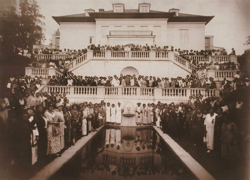
In 1916, America’s first black female self-made millionaire, Madam C.J. Walker, had a house built. And by house we mean mansion, one befitting her fortune and status, cleverly named Villa Lewaro—an amalgamation of her daughter’s first, middle, and last names (A’Lelia Walker Robinson). Walker was a trailblazing entrepreneur, and her beauty product company was at one time the largest black-owned business in the United States. Her Italianate villa in Irvington-on-Hudson, New York, is now in its hundredth year, and is being reimagined as a learning and leadership institute for female entrepreneurs of color.
The 28,000-square-foot estate, designed by Vertner Woodson Tandy (the first licensed black architect in New York State), was recently purchased by the New Voices Foundation for an undisclosed amount. The foundation is the nonprofit branch of the New Voices Fund, a $100 million investment fund dedicated to entrepreneurs following in Walker's footsteps. Both the fund and the foundation were created by Richelieu Dennis, a Liberian entrepreneur and investor, who will help oversee the transition of Villa Lewaro from a riverfront estate to a creative think tank. It’s notable that Dennis’s family founded Shea Moisture hair products, a business, like Walker’s, that was built on a family recipe for African-American beauty needs.
Though Walker only lived at Villa Lewaro for one year (from May 1918 until her death in May 1919), over time the home served as a cultural and intellectual meeting place for leaders of the Harlem Renaissance, such as Zora Neale Hurston and W.E.B. DuBois. Ultimately, the mansion “represents the fulfillment of Madam Walker’s goal to inspire future generations of African Americans and women,” says A’Lelia Bundles, great-great granddaughter of Walker.
Perhaps unsurprisingly, Walker was the first person of color to own property in tony Irvington. Villa Lewaro was situated along the aptly named “Millionaire’s Row,” so the beauty pioneer counted the Rockefellers and Astors as neighbors. A November 4, 1917, New York Times Magazine article reports that Walker’s move into the neighborhood was met with total disbelief. The article details the inside of Villa Lewaro, too. “It is 113 feet long, 60 wide, and stands in the centre of a four-and-a-quarter-acre plot. It is fireproof, of a structural tile with an outer covering of cream-colored stucco, and has thirty-four rooms. In the basement are a gymnasium, baths and showers, kitchen and pantry, servants’ dining room, power room for an organ, and storage vaults for valuables.”
All this belonged to a self-taught woman from the sharecropping South, who founded a company with a 3,000-person salesforce and up to $250,000 in annual sales (several million in today’s dollars). Walker also had a reputation for being an activist and major philanthropist for the black community. Throughout her life, she bequeathed nearly $100,000 to orphanages, schools, and other cultural institutions. In 1919, just before her death, she gifted the equivalent of $65,000 to the NAACP’s anti-lynching fund—their largest gift ever at the time.
Villa Lewaro was named a National Historical Landmark in 1976. In 2014, it was named a National Treasure by the National Trust for Historic Preservation. The New Voices Foundation is working with preservationists to ensure that the mansion is structurally sound, and with historians to give context to the time and place in which Villa Lewaro was built and furnished.
Bundles, a biographer and brand historian beyond being Walker’s descendant, looks forward to meeting the first cohort of entrepreneurs to use the space. “I hope their visit will inspire even more success [and] I hope they’ll incorporate Madam Walker’s practice of being a patron of the arts and a philanthropist who supported political, civic, and social justice causes,” she says. No centennial events have been announced for Villa Lewaro just yet, but the Madam Walker Legacy Center, an arts and culture space in Indianapolis (which hosted her company’s headquarters), will reopen this year after a renovation.
It was a two-man job. Bill Blair Sr., in a ‘39 Ford loaded with white liquor, hung back, while his friend Elmer sped down winding North Carolina roads as though he was riding the devil’s horse. “Agents would get after Elmer and chase him,” says Bill Blair, who inherited Blair Sr.’s name and love for racing. “My daddy would come down the road with nothing to bother him.”
The agents were from what’s now known as ATF: the Bureau of Alcohol, Tobacco, Firearms, and Explosives. But on this occasion, Elmer hesitated at a fork. Instead of picking left or right, he slid into a maple tree. According to Blair, Elmer shimmied out the window and hid. The agents, who assumed he’d run for the tree line, started shooting. “Daddy rolled up and he saw all that and slowed,” says Blair. “Elmer came out of that tree like a squirrel, opened the door, hopped in, and said ‘Let’s get out of here!’”
They had 40 miles to go and were weighed down by 120 gallons of white liquor. The ATF caught up to Blair Sr., inching next to them on the backroads. So the haulers tapped the government vehicle off the road and kept driving until they came to a row of cabins along the Dan River. The hideouts, Blair says, were big enough to drive inside, then put the doors down behind you.
This is one of many stories Blair grew up hearing from his father about his moonshining days. While the story, like many family legends, is difficult to verify, it fits with many other accounts. The almost-friendly rivalry between cops and bootleggers was such that the Atlanta police were quoted as calling moonshiner Roy Hall a "genius at the wheel" because of his ability to outrun the law.
Blair’s father started hauling moonshine in 1932, trying to liven up his dairy farm life in High Point, North Carolina. According to his father, he was “born to be hung.” Blair Sr. was a gearhead, a moonshiner, and a pool shark, and like so many trippers who raced illegal liquor from the swamps and forests of North Carolina to cities and mill towns, he was getting all the education he needed to become a stockcar driver.
The stakes of these races against the law were high, but many early NASCAR drivers got their start tripping whiskey down dirt roads in the South. While NASCAR downplayed it for generations, these are the sport’s roots. Names like Junior Johnson or Lloyd Seay are almost as synonymous with NASCAR as they are with white lightning and bootlegging.
Most people associate moonshine with Prohibition, but Americans have been making booze in the backwoods since there was a tax man come to collect on it. The United States wasn’t even a decade out of the Revolutionary War before Alexander Hamilton proposed a tax on domestic spirits—in other words, whiskey. Many farmers living near the Appalachian Mountains converted extra grain into spirits, and they hated the tax so much that they tarred and feathered collectors. President Washington had to send 13,000 troops to quell the rebellion.
Officially, the rebellion collapsed. But people continued making moonshine in the Appalachians. As more and more states prohibited alcohol in the 1900s—a prelude to national Prohibition in 1920—it was old hat for families who had been selling boozy wares tax-free for generations. “Most people in rural areas didn’t see [making moonshine] as illegal,” says Daniel S. Pierce, author of Real NASCAR, a book about the origins of the sport. “It was a violation of federal law, but that didn’t count.”
In the early days, moonshine was sold locally, to friends and family; Pierce says it’s unlikely that people moved moonshine more than 20 or 30 miles by wagon. It might have remained a small, lawless enterprise if Prohibition hadn’t coincided with the advent of mass-produced automobiles. Bootleggers replaced 40 gallon stills with stills that could hold up to 1,000 gallons and hid them in Appalachia’s mountains, swamps, and thick forests. The local geography lent itself to secrecy and speed. No matter how swampy the terrain, there was usually a road nearby which led to customers. By 1934, Neal Thompson writes in Driving with the Devil, as many as 35 million gallons of moonshine were produced nationwide.
Blair Sr. was just one of many young men whose love of cars and thrills got illicit booze into customers’ hands. While he and Elmer partnered to draw the ATF away from the real cargo, others turned off their lights and drove in the dark along lonely and jagged side roads. Moonshiner Smokey Purser used disguises from wearing a priest’s collar to writing “fresh Florida fish” on the side of his vehicle and throwing in some dead fish for good measure, Daniel S. Pierce writes in Real NASCAR. Trippers drove Ford V-8s, often modified with additional springs to keep contraband-loaded cars from sinking so low they tipped off authorities, and learned maneuvers like the “bootleg turn,” a high-speed dance of breaks and gears that turned the car 180 degrees.
“Moonshiners put more time, energy, thought, and love into their cars than any racers ever will,” moonshiner and NASCAR driver Junior Johnson once said. “Lose on the track and you go home. Lose with a load of whiskey and you go to jail.”
Auto racing was then dominated by AAA, which controlled the largest race, the Indy 500. “A Kentucky Derby-like air of of aristocracy hung over most races,” Thompson writes. “Fans were typically men, wearing suits and bowlers and smoking pipes.” Southern stockcar racing, with its desperado drivers and cars modified for whiskey tripping, was distinct. At first, races were informal affairs among drivers, but they quickly attracted spectators.
Early stockcar races were messy affairs with scrappy drivers and scrapped cars. Country drivers didn’t have automobiles crafted for racing; they were stock, no different from a family car, other than perhaps some modifications under the hood. Blair Sr., like many drivers of his day, purchased his car from a local junkyard dealer.
“The do-gooders didn’t go to stockcar racing,” Blair says. “You’d need to take a bath because it changes your shirt from white to red.”
On race day, you could see the dust cloud a mile away. Mud caked onto windshields and drivers put screens in front of radiators to protect them from dust. There were so many rocks on the track that racers scoured junkyards for new windshields. Drivers didn’t have jumpsuits, but wore primitive helmets and tied handkerchiefs around their faces like bank robbers. Lacking seat belts, they sometimes tied themselves in place with rope. “My daddy would spit red dirt until Tuesday,” Blair remembers. If your hands had blisters, you’d pop them until you had two bloody hands.
“He did it because he loved it,” Blair says of his father. “There was no money in it.” Drivers might collect $75 for winning, or they might find that a promoter ran off with the purse. There weren’t sponsors, Blair says. “White liquor was his sponsor.” Pierce writes that haulers could make as much as $450 a night driving moonshine well into the 1950s—income that was, of course, tax-free.
Blair’s father raced, he says, because “it made you somebody important.” Whether Blair Sr. was at a racetrack or visiting a small town, people stopped to talk to him. “It was like he had an entourage.” The family home was close to racetracks, and since it wasn’t easy to find a motel, people would stay at the Blair house in the grove of pin oak trees near the dairy. Blair remembers his mother making breakfast for the racers.
These races were gaining popularity when World War II hit. Many young men went off to fight or work in shipyards, and gasoline rationing was a temporary stop sign for automobile racing. But when the war ended, a former racer turned promoter known as Big Bill France changed the sport forever.
Until France came along, tracks made their own rules, and a hodgepodge of promoters, track owners, and sanctioning bodies put on each race. The AAA sponsored several stockcar races, Thomspon writes, but stopped in 1946, stating, “The Contest board is bitterly opposed to what it calls ‘junk car’ events.”
France had a chip on his shoulder about the respectability of races. According to Pierce, France’s life’s mission was to “raise the level of NASCAR and take it beyond a working class thing—increase the appeal to families and women and the middle class.” France began promoting races, taking money at the door, and offering bigger purses to attract the best racers. He created an organization called the NCSCC that paid drivers for each victory and offered a $1,000 prize to the driver with the most points from NCSCC races.
The crowds grew larger under France’s watch. People like Raymond Parks, a moonshiner who was the first team owner in the sport’s history, hired some of the best early racers, and new racetracks and speedways were built left and right. In 1947, the Blair family opened the Tri-City Speedway in North Carolina. The money Blair Sr. used to build that track wasn’t racing money; it was liquor money.
In 1947, a meeting of drivers, mechanics, team owners, and others important to the sport’s early success led to the official creation of NASCAR (renamed from NCSCC)—all under Bill France’s private ownership. While the crowds were good, France still wanted to attract the country club set to stockcar racing. In fact, NASCAR didn’t lift a rule that prevented liquor companies from sponsoring cars until 2005.
Yet moonshiners still raced. In NASCAR’s inaugural year, Blair Sr. won a championship race in Danville, Virginia, and would win another three among the 123 strictly stock races he participated in between 1949 and 1958. When Tom Wolfe famously wrote an article about Junior Johnson for Esquire in 1965, raising NASCAR’s profile tremendously, he highlighted Johnson’s history in bootlegging, including an arrest at his father's still.
Though the NASCAR Hall of Fame has a small section on moonshine, including one of Johnson’s stills, it downplays moonshine’s role. Pierce says it gives the impression that only a couple outliers were involved. But without the skill of young bootleggers, it’s possible that no one would have seen stockcars as something worth racing and watching. Moonshine was the fuel NASCAR raced on, while pretending it needed only gasoline.
That attitude may be changing. In October 2018, NASCAR joined forces with Tennessee’s Sugarlands Shine to sell an official moonshine. When asked whether it was correct to say NASCAR didn’t always publicize this part of its history, Chief Revenue Officer John Tuck stated by email, “Moonshine has a historic connection to the roots of our sport and that association has always been present with our fans ... who embrace the lineage of our sport."
The connection between NASCAR drivers and moonshine seems more corporate in recent years. In 2007, Johnson cashed in on his legacy by creating Midnight Moon—a “moonshine” made indoors at a legal distillery and sold in clear mason jars at stores. But some men just can’t stay away from the good stuff, the secretly stilled moonshine, white mule, or mountain dew. Just 10 years ago, former NASCAR driver Dean Combs was charged with operating an illegal still. “I’d drink it for a cold,” he told The Richmond-Times Dispatch. He’d made a batch that morning. Authorities confiscated over 200 gallons.
It's a recent riff on an ancient Scottish tradition.
For thousands of years, grassy hills across portions of Scotland and Ireland have been marked with massive rings of stones. These are known as recumbent stone circles, named for the central, signature slab splayed on its side and surrounded by a flock of vertical sentinels. It’s thought that the Bronze Age monuments may have been erected for rituals, as burial sites, or to frame the moon. They number close to 200. But researchers in Leochel-Cushnie, a parish in Aberdeenshire, Scotland, recently learned that a local one is a whole lot younger than the rest.
Neil Ackerman, historic environment record assistant at the Aberdeenshire council, was part of a team that went out to look at the circle in November 2018, after locals tipped researchers off about some old-looking stones stuck into a field. It was hard to say for sure, but, at first, nothing seemed especially off to Ackerman or his fellow scouts, representing Historic Environment Scotland.
True, this circle was notably smaller than many others, but plenty about it fit. The tipped-over stone was oriented southwest, for one thing, as is the case with many other monuments of this type. Like many of its peers, it was positioned with hillside views. The stones were stippled with lichen, which Adam Welfare, of Historic Environment Scotland, interpreted at the time as "indicative of the ring's antiquity." The stones also lacked "fresh breaks or quarrying marks," Ackerman says, which would have suggested that they were modern replicas.
Yes, sure—most of the known circles were recorded decades (or even centuries) ago, but Ackerman didn't read too much into it. This one was in a dip in the field, off the beaten track. "There was a decent possibility that it might have just been missed," says Ackerman.
Upon closer look, though, the stones did show some signs of modern meddling. “Our detailed survey revealed that some of the stones were placed in a way that suggested at least modern alterations,” Ackerman says.” Even that wasn't especially odd, or a sign that these weren't old, after all. “Stones can fall and be reset in a slightly different position over time,” Ackerman says. (Researchers have also suggested that Stonehenge has been freshened up over the years—sometimes with the heavy-duty help of concrete and cranes.)
So, was it old, new, or something in between? It's notoriously difficult to date these stone circles—they're not often paired with, say, bits of bone, tools, or pottery that might hold clues about their age—but the council thought it passed muster, and blasted out the news of the new, old find in December 2018. "This amazing new site adds to our knowledge of these unique monuments and of the prehistoric archaeology of the area," Ackerman said at the time.
Then, this week, the same folks who had celebrated the find announced that the jig was up: A former owner of the farm confirmed that they’d laid the stones in the mid-1990s. That owner had an interest in archaeology, and built this replica as a garden feature, Ackerman says. They recently got in touch with Historic Environment Scotland to clear up questions when the stones began making headlines as a rediscovered relic.
On Twitter, Ackerman described the initial sting of getting it wrong, with a self-deprecating deadpan: "If you are having an awkward day at work, at least you're not that guy who identified a new prehistoric stone circle to the press that now turns out to be about 20 years old." Ina fresh news release, though, Ackerman spun the mix-up in a positive light—as a win for both archaeology and the region’s ongoing enthusiasm for its long history. Even if the arrangement is not ancient, Ackerman reasoned, it’s still pretty cool. “I hope the stones continue to be used and enjoyed,” Ackerman said. “It is still in a fantastic location and makes for a great feature in the landscape.”
A new way to experience Atlas Obscura with fellow explorers like you.
I'm very happy to introduce the Atlas Obscura Community forums, a whole new way to interact with Atlas Obscura and connect with curious travelers just like you.
For the past decade, Atlas Obscura has asked you to tell us about the fascinating and wonderful places you’ve found in the world, and it has been our pleasure to share those experiences and discoveries with our readers. We’ve always wanted to foster a true community of active explorers, a living resource for finding and sharing the world’s hidden wonders. With the launch of our forums, that dream is taking another great leap forward.
The Community forums offer several new ways to enjoy Atlas Obscura, both as a traveler and as a reader.
Going forward, each Place and Food published on our site will include a new area for you to discuss that entry with others. You'll find these discussions at the bottom of each page and be able to ask questions, discover what fellow Atlas Obscura readers have to say about their experiences, or share tips of your own. Want to know how big Mexico’s Disc of Death really is? Need to find out whether Beijing’s Friends-themed cafe is worth the hype? Looking for a local business near you that sells Polish Pączki? Want to share your family’s recipe for Colcannon? Our new forums are the place to be.
Atlas Obscura’s Community forums also offer a space for more general conversation about the fascinating corners of our world, and the many incredible ways we can experience them. We encourage polite, interested dialogue, and invite you to join in the conversation. Looking for the perfect movie to get you in the mood for an upcoming trip? Wondering what wonders to visit on a trip to Las Vegas? Have pictures of an unusual personal collection that you’d like to share? Want to tell that story of the cheese-rolling competition you attended? We’re here for it.
The forums are a place where we’re excited to get to know you, the explorers and travelers who have helped make Atlas Obscura what it is today. We’re happy to answer any questions you might have, and we might even look to you for answers to some of our own.
You can reach the Community forums at any time by joining or starting a conversation via a Place or Food entry, or by visiting community.atlasobscura.com. Join us in the forums and together we can bring even more wonder to your travel. If you have any questions at all about the Community forums, or how you can join in, please feel free to contact me at eric@atlasobscura.com. Let’s talk!
Tonika Lewis Johnson, a local artist and activist, connects individuals from the North and South Sides through her art.
How do you find connections in a deeply segregated city? For the Chicago photographer and activist Tonika Lewis Johnson, the answer was simply to fold it in half. For her “Folded Map” project, Johnson photographed corresponding addresses on Chicago’s North and South Sides. She set the images side by side to highlight the impacts of decades of segregation and disparities in city resources.
That was how it began, at least. Johnson quickly discovered her subjects were also interested in getting to know one another. So she began connecting what she calls “map twins” and encouraged them to experience each other’s neighborhoods while she filmed the exchanges. To pair the map twins (there are currently four sets), Johnson used Google Maps to find matching addresses in the South Side Englewood neighborhood and on the far North Side, in the Edgewater and Rogers Park neighborhoods. Some were exact addresses while others were in the same area but on different blocks. Her photos were displayed alongside video conversations between the pairs at a Loyola University Museum of Art exhibit in 2018. Now, she is building a website to showcase “Folded Map” and connect future address pairs.
“The heart of ‘Folded Map’ illuminates our Midwestern sensibilities,” says Johnson. “Even though Chicago is huge, we still feel we should connect... We recognize when our city has a hand in not creating opportunities for us to get to know each other.”
Economic growth during the 19th and 20th centuries helped Chicago become a leader in industry, education, and cultural institutions. But racial and class segregation made it difficult for the city’s growing African-American and immigrant populations to access these resources. More than half a million African Americans came to Chicago as part of the Great Migration, forming a South Side "Black Belt" while immigrants from Eastern Europe, Latin America, Sub-Saharan Africa, and other areas built their own communities.
City, state, and federal policies as well as racial violence kept communities of color in certain areas during the 20th century. “Mapping Inequity: Redlining in New Deal America,” an online collection of federal Home Owners’ Loan Corporation maps and accompanying descriptions from 1935-1940, shows that in Chicago and cities around the country, black, Hispanic, and many Asian groups were segregated into neighborhoods deemed less desirable. Redlining, the process of refusing loans because of perceived financial risk, prevented many communities of color from owning homes and building generational wealth. White flight followed the construction of highways in largely African-American neighborhoods. Despite the passing of the 1968 Fair Housing Act that made housing discrimination illegal, little changed in Chicago.
As a result, the urban geography of Chicago became split by race: a black South Side separated by downtown from a white North Side and a largely Hispanic and black West Side. There are areas that defied segregation: The North Side Rogers Park neighborhood, which was included in “Folded Map,” is known for its racial diversity, with prominent Jewish Orthodox and African and South Asian immigrant communities. But in general, North, South, and West Side neighborhoods have been defined by inequitable distributions of educational, cultural, and economic resources.
These divisions continue to harm residents across races: A 2017 study by the Urban Institute and the Metropolitan Planning Council found that a decrease in Chicago’s segregation would increase per capita income for African Americans and educational attainment for both black and white residents. It would also decrease the homicide rate.
As a teenager, Johnson saw these divisions firsthand as she traveled from her South Side Englewood neighborhood to her magnet high school on the city’s North Side. While Johnson enjoyed the more varied economic and entertainment opportunities while living on the North Side after high school, she eventually found herself drawn back to her childhood neighborhood. In 2008, frustrated by the media narrative of gun violence on the South Side, Johnson began capturing rituals and normal goings-on for the photo project “Everyday Englewood.” Her images of children playing and families together were displayed at the Loyola University Museum of Art in 2018 and on five billboards around Englewood in 2017 as part of the Englewood Rising campaign. In 2011, Johnson also co-founded the Residents Association of Greater Englewood (RAGE), because “if the elected official won't unify to create solutions, tangible solutions,” she says, “then the residents have to, which is nothing new.”
Building on these earlier projects, Johnson started “Folded Map” in 2017 to show that residents have the power to cross the invisible lines between neighborhoods. She says she wanted to portray both sides of the city with dignity because “for the residents who are trying to transform issues, people do tend to view them as victims but victims of their own circumstance or their neighborhood's own circumstance. I wanted to push people to expand that thinking, to understand actually what you're witnessing is resilience.”
Through Johnson’s guidance, which came in the form of a specific list of questions she asked each pair together, map twins discussed topics including race and socioeconomic status in each other’s living spaces. Describing some of the takeaways from those conversations, Johnson says South Siders are largely shocked by the price of homes in more affluent neighborhoods while North Siders are “realizing in that moment that they’re a beneficiary of inequity, and that's difficult to realize in the face of someone who they want to get to know, telling them they're on the opposite end of that.”
In 2017, Johnson paired Maurice “Pha’tal” Perkins, a community leader and rapper living in Englewood, with Jon and Paula Silverstein, who live in Rogers Park and work in an alderman’s office and for a foreign exchange program nonprofit respectively. Perkins says a highlight of making this connection was having the Silversteins attend a night-time bike ride and show genuine concern for a neighborhood that was not their own. “I'd like to think maybe it's the start of a movement,” says Jon Silverstein of the project. “I'd love to see more and more people in the city start to build these relationships.”
Brighid O'Shaughnessy, who was living in Rogers Park during her participation in the “Folded Map” project, and Carmen Arnold-Stratton, who lives in Englewood, formed another pair of map twins.
“What I got out of it was that there is still very much a division here in Chicago amongst people of various backgrounds and color,” says Arnold-Stratton, who works as a bus driver. “But Tonika [Johnson] brought people together that would have never otherwise come together or had gone to the other side of the city to see how other people lived.”
When O'Shaughnessy adopted her son from Haiti, she wanted to raise him in Rogers Park, where he could play outdoors. When she went to Arnold-Stratton’s residence in Englewood, they bonded over the fact that both had dealt with house break-ins. “We spoke pretty candidly about desiring safety and longed for a neighborhood where people had our backs,” says O’Shaughnessy.
O’Shaughnessy, who is a healer, artist, and activist, developed a theatrical version of “Folded Map” that she hopes will encourage the audience to think about “what is the narrative I'm holding about my own experience and what does it mean if I widen that narrative to include other communities I could engage with.”
Meanwhile, Johnson continues to build a future for “Folded Map.” Hundreds of Chicago residents have filled out an online form to express interest in participating and Johnson is beginning a second part of the project, photographing the city’s West Side. She is also embracing new undertakings as well: Building off her experiences commuting to school and raising two teenage children in the city, she started a project tentatively titled “Belonging,” focused on how youth of color navigate Chicago. For the future of “Folded Map,” she says she is excited about creators across the country exploring how their cities fold and how racial divisions can be bridged.
Ultimately, Johnson says “Folded Map” has taught her the importance of exploring how the design of a city controls how people interact. “I think it's something that we forget,” she says. “The consequence of that is sometimes feeling guilty thinking that we contribute to whatever horrible inequity is in our city. When it really just shines a light on how we should all get together to demand more of our local government to change some stuff.”
We all have a cousin like the hagfish, right? One who uses a prickly tongue to skin its prey, and fends off its enemies by suffocating them with slime? Depending on which hypothesis you subscribe to, these ancient, eel-like assailants reign near the base of our common vertebrate family tree. It would seem to explain a lot.
New research, however—published yesterday in the Proceedings of the National Academy of Sciences—supports another theory: that the hagfish was separated long ago from the lineage that spawned more modern fish and other vertebrates (like us). Perhaps we need to take more ownership of our most vicious tendencies.
The research focuses on the first proper hagfish fossil ever found—a 12-inch long, 100-million-year-old specimen caked into limestone from the Cretaceous period, bearing telltale evidence of slime production. (The fossil was uncovered in present-day Hjoula, Lebanon.) Slime may not seem like the kind of substance primed to fossilize, but it was precisely the hagfish’s rare, viscous defense mechanism that helped the researchers properly identify the fossil.
The giveaway was the keratin found in synchrotron scans of the specimen. In self-defense, hagfish can deploy tightly coiled keratin fibers, like balls of yarn that unfurl instantaneously upon reacting with ions in the water, explains the study’s lead author Tetsuto Miyashita, of the University of Chicago. The fiber balls then trap water within, sliming up the surroundings so that predators can no longer breathe. The fossil contained more than 100 concentrations of keratin; this, combined with the fossil's age, suggests that hagfish were using slime against such ancient adversaries as plesiosaurs and ichthyosaurs. Today, says Miyashita, the slime is still a major nuisance to fishermen, who have to powerwash their nets that emerge crusted in the cobweb-like residue.
Any hagfish fossil, souped-up with evidence of the animal’s slimy defense system, would have been an impressive discovery no matter what. The fossil is particularly important, however, because it helps to clarify the hagfish’s murky position within evolutionary history. According to a press release, scientists studying hagfish have been divided over what the limited evidence suggested. An older hypothesis held that hagfish and lampreys—similarly intimidating (if tastier) bloodsuckers of the bottom of the sea—made up separate branches on the evolutionary tree that led to more typical fish and, well, us. In this telling, says Miyashita, the two groups were considered “living fossils” that, because they still appear so primitive, must retain many characteristics of our common ancestors from more than 500 million years ago.
Those researchers focused on the genetics, meanwhile, have argued that hagfish and lampreys are related to each other, but not to other vertebrates. They ought to be studied as a separate group, and our common vertebrate ancestor ought to be reimagined as a more typical fish. Miyashita’s research reinforces this latter hypothesis, but does so by fusing—for the first time—fossil analysis with genetic analysis. Maybe we’re not as much like the hagfish as we thought, or wished, or feared.
Let Atlas Obscura readers take you on a tour of the world in 100+ songs.
Right up there with love and partying, places are one of the most popular subjects for musicians to write songs about. Songs about cities, neighborhoods, and even individual streets have a way of transporting, and connecting with listeners. Hearing someone belt out an ode to your hometown—or someplace you've never been but always wanted to visit—can be an emotional experience. But don’t take our word for it. We recently asked Atlas Obscura readers about their favorite songs about places, and the response was overwhelming!
We received hundreds of nominations ranging from descriptive musical tours of entire towns to heart-rending breakup songs that just happen to mention a specific place. In case you were curious, by far the most beloved song about a place was the John Denver classic, “Take Me Home, Country Roads.” Songs about Texas and California outnumbered songs about any other places, although New York was another popular subject. But you also wrote to us to recommend songs about subjects like Bobcaygeon, Ontario, the beaches of Hawaii, and the streets of Barcelona.
Take a look at some of the best reader descriptions of their favorite songs immediately below, and then keep scrolling to find a Spotify playlist of 100+ songs about places suggested by you! Since we certainly haven't included every song ever written about a place, if you have a favorite song about a place that you'd like to share, head over to our new community forums and tell us about it.
"Fall in Philadelphia" by Hall & Oates
“The song came out while I was in high school. For me, the song equals nostalgia, civic pride, and the imagery of fall in this city. [It’s] poignant.” — Amy Keyser, Philadelphia, Pennsylvania
"One Great City!" by The Weakerthans
“It's a love/hate song to Winnipeg, a city I've been to a number of times and have alternately liked and hated myself. The song's writer, John K. Samson, is a native of the city. He captures perfectly in the lyrics the yearning and exasperation one feels for a hometown that's never quite lived up to its potential. Winnipeg can be strikingly beautiful at times (come visit it in the fall when the landscape is changing from green to red and gold to brown), but the winters can be horribly bleak and isolating, and the summers, humid and buggy. It's surprising then that "One Great City!" is such a lovely, funny song.” — Hisaye, Bay Area, California
“Amarillo by Morning” by George Strait
“It's about the greatest hometown on the planet.” — Jenny Sumsion, Utah
“Take Me Home, Country Roads” by John Denver
“Ok, so it wasn't actually written with West Virginia in mind. We West Virginians know this. We don't care. I've lived in WV all my life, minus six years when I lived overseas. During that time, this song used to make me cry, was so homesick.” — Melody Siracusa, Morgantown, West Virginia
“I Love L.A.” by Randy Newman
“It is PERFECTLY SoCal in the '80s.” — Peter Newton, Phoenix, Arizona
“Nutbush City Limits” by Tina Turner
“Whenever I hear it, it makes me wonder what Nutbush is like. And why anyone would want to write a song about it.” — Ian Jarrett, Perth, Australia
“Thrice All American” by Neko Case
“I've never been to Tacoma, but I think this song was made for me, a foreign-born kid who moved to the U.S. I started falling in love with the United States, because it could inspire such heart-rending loyalty from someone. It wasn't something that I'd personally felt before!” — Patrick L., Chicago, Illinois
“Twin Falls” by Built to Spill
“I lived in Twin for a while. This song captures the melancholy nostalgia of leaving behind a small town childhood.” — Zac Castro, Coeur d'Alene, Idaho
“Youngstown” by Bruce Springsteen
“I grew up in Youngstown, which was a thoroughly bleak place. I've never met Bruce Springsteen, but after listening to this song (and many others), I feel like he knows me.” — Vince Guerrieri, Elyria, Ohio
Part of the goal is to inspire greater appreciation for these mossy structures.
Have you ever walked down your local trail and stumbled upon a random stone wall that looks as if it grew from the ground itself? No doubt it was built by someone and is extremely old, but why was it built? Was it the boundary for livestock on an old homestead, or perhaps a line of defense? The New Hampshire Department of Environmental Services is trying to answer some of those questions for the state’s mossy partitions.
New England is somewhat of a stone wall hotspot. Around 100,000 miles of walls dot the region’s woodlands and countrysides. Most of these walls weren’t built deliberately, but were instead a convenient way for farmers in previous centuries to discard plow-impeding rocks from their fields. In the years since, many of those stretches of farmland have become reforested.
To learn more about these structures, the DES launched a crowdsourced initiative to map every stone wall in the state, using Light Detection and Ranging (LiDAR) mapping. LiDAR utilizes lasers to produce geological surveys showing land elevation.
Through an interactive interface known as the New Hampshire Stone Wall Mapper, interested parties can map the plethora of walls from the resulting aerial imagery. The platform allows anyone with a computer and internet access to trace the walls right onto LiDAR images. Once complete, users can input where a given structure is located, along with any observations about the wall's condition. You can also upload images. It then appears on the main map as a pink line, containing all the relevant information. DES state geologist Rick Chormann also hopes that people will take the time to write about their personal experiences with the wall they mapped.
The ultimate goal is to develop a historical database that can be used for decades to come. But it’s also about garnering more love for the walls.
“My primary motivations for the project were to raise awareness of the state’s stone wall legacy and inspire greater appreciation for them, which hopefully will lead to greater preservation, and to promote use and understanding of the state’s LiDAR data,” says Chormann, in an email.
By taking this unique approach, Chormann hopes it provides a fun new perspective on New Hampshire’s landscape. It also gives people the chance to learn more about their state's past.
A new installation at the Detroit Public Library conjures a lost community.
The plywood frames are skinny and shallow, like the featherweight facades of a stage set. Look closely at one, and the next, and the next, and the shapes of windows and doors will appear. Over time, they begin to conjure a block, and then a whole neighborhood.
Inside the main branch of the Detroit Public Library, visitors can now walk through a photo installation that recreates the streets of Black Bottom, a Detroit community that was razed more than half a century ago. The plywood frames, part of the Black Bottom Street View project, on view through March 2019, occupy almost all of the library’s soaring Strohm Hall and are laid out to recall the street grid of the old neighborhood. For the exhibition, Emily Kutil—an architect and scholar at the University of Detroit Mercy—wrapped the frames with layered photographic montages of the streets as they appeared in 1950, just before the neighborhood was dismantled. The result evokes the sensation of strolling through the community house by house, paying tribute to a place that has left few other traces on the landscape.
Before Black Bottom became one of the first U.S. neighborhoods knocked down in the name of midcentury urban renewal, with funding from the Federal Housing Act of 1949, it was full of people, of homes and cars, lawns and porches. In the early 20th century, Detroit’s African-American population swelled as families streamed out of the Jim Crow–era South. Between 1910 and 1940, the city’s black population climbed by more than 34 percentage points.
Many of these newcomers settled in Black Bottom, where races and socioeconomic classes mingled. “Black people lived here, yes, but so did immigrants from Ireland, Poland, Greece,” says Jamon Jordan, a historian who leads tours of the area. “In the teens, 20s, and 30s, you had a black doctor living next to a family that had just arrived in the city,” Kutil says. (Coleman Young, who would go on to be the city’s first black mayor, moved there from Alabama as a young child.) Some say the neighborhood’s name was a nod to its dark, fertile, soil, while others suggest that it was a snide comment about the demographics of its residents. “In its heyday, it was a thriving African-American community," Kutil says, "in a time when the forces that be were doing their darnedest to prevent the African-American community from thriving." Though the neighborhood’s struggles are well documented—overcrowding, absentee landlords, and some dilapidated buildings—Black Bottom was vibrant.
After World War II, city leaders came to see the neighborhood as a bad thing for the city, and officials laid out an economic case for destroying it, estimating that, after redevelopment, the value of the land and new buildings would soar by 725 percent. With Federal Housing Act funding in hand, officials moved forward with eminent domain. When wrecking crews leveled the existing homes and businesses beginning in the 1950s, in the name of removing a blight on the city, many residents viewed the project more as a way to eject and stunt the black community.
The city government offered a little more than $6 million in total to buy up the land. As part of the eminent domain process, officials photographed each parcel, and every image was labeled with the address and date. Civic organizations, shops, and churches had flourished alongside the homes, and some of the houses of worship are still standing on the distant edges of the historic neighborhood. Closer to the core, almost nothing was spared, Jordan says. “Most of the institutions that were in the center, no matter what religious group or culture, they’re gone.”
After residents were removed and buildings demolished, the area sat fallow for a few years—Kutil says locals recall vacant land dotted with handsome old trees and roamed by feral dogs—before new roads were laid down and high-rise housing built up. Ultimately, the neighborhood was replaced with the Chrysler Freeway and a slew of new buildings that went up in the 1960s, 70s, and 80s, including Lafayette Park, a cluster of mixed-density housing designed by Ludwig Mies van der Rohe. Now, “everything in that area is post–Black Bottom,” Jordan says.
Decades later, boxes of these Black Bottom photos, other eminent domain documents, and more were found in library storage, and then digitized by the Burton Historical Collection, where researchers recognized the materials as an accidental archive of a neighborhood’s final days. The pictures that remain only account for about one-fifth of the homes that once stood in the community, Kutil says. But cataloging, digitizing, and mounting them “is like bringing to life the Lost City of Atlantis,” local writer and activist known as Marsha Music recently told the Detroit Free Press. Kutil, who also does activist work around current development projects in Detroit, initially planned to draw the neighborhood and stitch her sketches together. But then she realized the potency of the photographs, as a true visual account of the yards, the balconies, the faces.
Though the neighborhood’s physical traces are largely gone, its legacy remains. Many people with deep roots in the city can trace their families back to Black Bottom, and commemorate the vanished neighborhood in art or exhibitions. When Jordan’s tour groups visit the former neighborhood, they juxtapose information about the past with realities of the present and try to grapple with the gulf between the two.
Plans are also now in the works for a historic plaque to pay tribute to Black Bottom. When a team at the Michigan History Center, which triages applications for such historic markers, read through the application, they thought, “Well duh, yeah, it’s significant!” says Tobi Voight, the community engagement director, who previously worked at the Detroit Historical Society. At the same time, the group thought that “a marker for a community this big shouldn’t be created by a commission or one applicant,” Voight says. So they convened a discussion with the Michigan Historical Commission, the Detroit Historical Society’s Black Historic Sites Committee, and residents, to gather personal stories and start to figure out where the marker ought to go and what it should say. “We’ve got 1,000 characters,” Voight says. “We have to sum up 150 years of history in two paragraphs.”
Talking to community members, Voight says, she realized that the marker alone—which will join 1,700 others across the state, on everything from lighthouses to relics of the timber industry—felt like a tangible validation. “It’s a symbol that ‘My story matters,’” Voight says, even if the footprint of the community is long gone. While conversations are ongoing, both Voight and Jordan, who is active in the discussions, are optimistic that it will go up in the next year or so.
Meanwhile, Kutil hopes that the Black Bottom Street View installation—and future iterations, including a website made in partnership with the Black Bottom Archives, where people will be able to contribute personal histories—will be useful for both old timers and people who don’t have a direct connection with the neighborhood. For those who remember growing up there, Kutil says, “it can be kind of cathartic to put yourself in that place again.” Outsiders “may have a skewed conception of what it is,” she adds, “and still talk about it as though it was a terrible place that needed to get destroyed. I hope it myth-busts some of that, too.”
Atlas Obscura and Chase Sapphire® teamed up to create an event that made the case for Philly as the ultimate artistic muse.
Brendan Lowry, the creator of the popular Instagram account Peopledelphia, endeavors to capture places, faces, and movements that others might overlook. "Forcing myself to not always look at what everyone else is looking at, to look the other way and point my camera in that direction, is exciting to me," he says.
Lowry was presenter at Assembly: Underground Films and Philly Legends, a joint endeavor between Atlas Obscura and Chase Sapphire® that celebrated the city's rich film culture. In many ways, Philadelphia is the perfect setting for his mission—it's a city that hasn't always gotten its due, but is nonetheless brimming with history and culture. "I don't think people realize how much is happening in Philadelphia and how many hidden gems there are," Lowry says.
For residents, Philadelphia's trove of wonders aren't exactly hidden. They're part of the city's foundation and the reason why one of America's oldest ports remains a vibrant place to live and create.
Bok Auditorium is a shining example of Philly's adaptive ingenuity. Located in a massive former school built in the Art Deco style, the building sat vacant for years before it was gradually repurposed as a civic space for artists, activists, and community members. The building's vast potential was on full display at Assembly. Creators and community organizers rallied to screen films that capture Philadelphia's past, present, and cinematic future, addressing a rapt crowd between titles.
Watch the video above to learn more about the state of art in Philadelphia for yourself. Spoiler alert: it's never been better.
And they have the "Ancient Lights" signs to prove it.
Perhaps you’ve heard the term “spite house,” or a building erected on a small slice of land after a dispute between neighbors. These inconvenient, often scarcely usable homes are explicitly designed for revenge, sometimes by blocking a hated neighbor’s view. Infamous examples include the 10-foot-wide Alameda Spite House and the sliver-thin house in Beirut, Lebanon, known only as "The Grudge." Fortunately for some property owners in England, no window-blocking buildings should be built any time soon, thanks to a property law that’s been around, in some form, since 1663.
The “Right to Light” is a stipulation that falls under the Ancient Lights law, which gives long-standing property owners the right to receive adequate and unobstructed daylight through their building’s windows. A person was historically entitled to this if natural light and air had passed freely through their windows for a certain amount of time. In a British law dictionary written by John Bouvier in 1856, he described the Ancient Lights law as applying to “windows which have been opened for twenty years or more, and enjoyed without molestation by the owner of the house.” If a neighbor attempted to infringe upon this by building a structure or planting trees, the owner had the power to sue them for “nuisance” and walk away with a check (and, ideally, a restored view).
This law led to the careful placement of “Ancient Lights” signs under windows that were protected by the ordinance. And today these signs are still found on buildings around London and other English counties, such as Dorset and Kent. Curious explorers have even created a map of where these antiques are located; popular ones include those underneath the back windows of homes on Albemarle Way, a seemingly misplaced one in a dead-end alleyway in London’s Chinatown, and a large, boldly printed sign in Newman Passage.
How much natural light is a person entitled to? Well, that’s where this law gets a little … shady. A building owner’s windows don’t even have to be completely blocked by a neighboring obstruction for the “Right to Light” to be invoked. It simply insists that the same level of illumination the owner has experienced for twenty years must be maintained, which is decidedly vague. A famous 1904 legal case, Colls v. Home & Colonial Stores Ltd, determined that Colls, the owner of a nearby building, was entitled to “sufficient light according to the ordinary notions of mankind” (yeah, that’s clearer) after he argued that his ground floor office would suffer from the loss of sunlight if the store was built. Colls won the case thanks to the “expert witnesses” the court deferred to.
Percy Waldram, one of these Ancient Lights experts, proposed a method in the 1920s that would, ideally, standardize the sufficient amount of light people could claim. He suggested that “ordinary people” required one foot-candle (a measure of light intensity) for reading and other work. While this quasi-arbitrary method is still in use today, it’s met with skepticism.
Though this 17th-century urban planning law has been through changes since it was first inked (the language England uses today is based more closely on the Prescription Act of 1832), the power that property owners have to demand ample daylight is still a relevant debate. The Ancient Lights doctrine hasn’t caught on in the United States, since restricting building construction threatens new commercial and residential development projects, thus limiting urban growth—at the cost, perhaps, of some daylight.
This imaginative gadget was designed to get operatives out of difficult situations.
Among the espionage artifacts on display at the International Spy Museum in Washington, D.C., is the rectal tool kit: a tightly sealed, pill-shaped container full of tools that could aid an escape from various sticky situations. This gadget was issued to CIA operatives during the height of the Cold War, according to museum curator and historian Vince Houghton. The tools inside the kit include drill bits, saws and knives.
“What I see when I look at the rectal tool kit is a great example of problem solving in the intelligence world,” Houghton says. It had to be made with materials that could not splinter or create sharp edges that could injure users. Additionally, it had to seal tightly to not let anything seep in or poke out. According to Houghton, the kits supplied spies with all the tools to break out of a jail cell, and “sometimes this was a matter of life and death.”
In the video above, Atlas Obscura takes an up-close look inside the rectal tool kit.