It's an elaborate tomb, with stones gathered from hither and yon.
For millennia, megaliths were humankind’s biggest, boldest way to show a mortal or deity that you cared. And few places host more of these massive, enigmatic stone structures than France, where many megaliths are clustered in Brittany and other northern regions. Long before William the Conqueror or the cultivation of wine, prehistoric communities left their mark by erecting the standing stones.
Now, roadwork in Puy-de-Dôme, France, between the cities of Bordeaux and Lyon, has revealed that the ancient stone footprint is a little bigger than previously thought.
In September, a team led by Ivy Thomson, an archaeologist with the National Institute for Preventive Archaeological Research (INRAP), unearthed a rocky trove: about 30 basalt stones, called menhirs, in a 500-foot-long line; five menhirs arranged in a horseshoe shape; and a single limestone rock roughly carved to resemble a human. The stones in the alignment generally got smaller the farther south they were found, suggesting an intentional north-south plane in the construction of the monument.
“Before this discovery, we thought that the megalithic culture never really reached the center of France,” says Thomson. “It’s the first site [here] that can be called a megalithic monument.”
Besides the curious alignments, Thomson’s team found a rock-adorned tomb that housed a single skeleton. Adding to the mystery, all the menhirs, and the tomb itself, had been knocked down and covered up, in what may have been an act of ancient iconoclasm. But without further evidence, it’s hard to solve the whodunnit.
Megaliths are, by definition, huge. But they weren’t all created equal, or assembled for the same reason. Around the world, researchers have found megaliths comprising everything from ancient calendars to ritual sites. Some are stone monuments like Stonehenge; others are tombs like Ireland’s Brownshill Dolmen. The four-acre site at Puy-de-Dôme may have been a bit of both.
“This is an exceptional tomb,” says Thomson. “It is monumental, involving [a lot of people in its] construction, yet it [contains] only one individual. It is undeniable that the man for whom this tomb was built was a person of great importance.”
After the team conducted its initial analysis, the important artifacts—the carved limestone, the well-preserved stones, and the human remains—were removed from the site, and roadwork was allowed to continue. Now, the finds from Puy-de-Dôme are housed at INRAP’s lab in Clermont-Ferrand.
The megalithic site hasn’t been dated yet, but Thomson’s team has thoroughly documented the area with photographs, drawings, topographic surveys, and more. Radiocarbon dating the sole skeleton will likely help researchers figure out when, exactly, all the heavy construction took place.
Thomson says the stones that composed the tomb and surrounding megaliths—some of which weighed a ton—were brought to Puy-de-Dôme from multiple sites in the surrounding area. The stones’ numerous origins may suggest that several communities were involved in the construction of the site.
Cleary there are still a lot of unknowns, and Thomson’s team has a lot of analysis left to do. “One thing is certain, however, and that is the most important thing,” Thomson says. “[T]hese megalithic constructions involved a huge [amount of] manpower and collective work.”
An exhibit documents the obstacles we erect, and how we overcome them.
The Cold War was long, but by many accounts parts of its end—namely, the fall of the Berlin Wall—felt rather sudden. At a press conference on November 9, 1989, an East German government spokesman surprised everyone, including himself, when he announced that private travel would be allowed through border gates between East and West Germany, effective immediately. No one had told border guards, such as Lieutenant-Colonel Harald Jäger, as people started amassing at crossings. Jäger told Der Spiegel in 2009 that he had spoken with commanding officials, but there were no clear orders from above. Jäger said, “ … people could have been injured or killed even without shots being fired. In scuffles, or if there had been panic among the thousands gathered at the border crossing. That's why I gave my people the order: Open the barrier!” And that was the beginning of the end for one of the modern world’s most famous walls.
The 30th anniversary of the opening of the Berlin Wall helped inspire the exhibition W|ALLS: Defend, Divide, and the Divine at the Annenberg Space for Photography in Los Angeles, according to Jen Sudul Edwards, who curated the show. With more than 70 artists and photographers participating, it presents a rich range of how dividers are portrayed—and it’s not all simply about architecture. “A wall for us is any type of barrier—emotional or physical,” says Edwards, who is chief curator at the Mint Museum in Charlotte, North Carolina. The photographs portray how people are constrained by or resist walls and barriers, even when they are not visible. In one photograph, by SHAN Wallace, hands connect despite the separation of the rest of the bodies. In Raymond Thompson Jr.’s image of teenagers playing basketball at a juvenile detention facility, the metal fences around them are just one of the barriers they will face. Photographer Carol Guzy captured the moment at a refugee camp in Albania when a child was handed through a barbed-wire fence to relatives.
Edwards shares how the show was conceived, the future of walls, and some of her favorite images from the show. The exhibition is on view until December 29, 2019.
What inspired the theme for this show?
Katie Hollander, the director for the Annenberg Space for Photography, brought the idea to me. She realized that, as we approached the 30th anniversary of the fall of the Berlin Wall, we were seeing, hearing about, and obsessed with walls dividing nations more than ever before in our lifetime. As we started to do the research, we found out that this was, in fact, true. When the Berlin Wall came down in 1989, there were 30 walls dividing nations, and when W|ALLS opened, the number was 77 and rising, with over a third of the world’s nation-states defining their borders with a barrier.
How did you select photos for the show?
Broadly speaking, we sought to include as many regions and time periods as possible. We hoped to have all seven continents represented—we ended up with six—and both natural and human-made “walls.” Each photo had to refer to a barrier, but it also had to be poignant, whether that was because the image itself was beautiful or because it hinted at a story or revealed a narrative.
Ultimately, we organized the show into six categories—delineation, deterrent, defense, decoration, the divine, and the invisible—because we felt they covered all the reasons humans erect such barriers.
What conversations are you hoping the photos will provoke?
I hope that people recognize that walls are a human response to conflict and anxiety, not just a local, national, or contemporary issue. I also hope that the photographs prompt people to think about why we erect barriers, and to what end. Are they solving a problem or are they just a way to postpone dealing with true conflict? Finally, I want people to recognize the multivalent, morphing nature of a wall’s meaning—its function and significance changes over time and depends on who interacts with it. Police can erect a barrier to control a crowd and the crowd can, in turn, graffiti messages of protest onto that barrier. Who does that barrier belong to? Who is controlling whom and what?
What was most challenging about putting the show together?
I very much wanted the show to maintain a level of objectivity—or, at least, to present the whole issue and not just one side. I fundamentally do not believe that people can divorce themselves completely from their experiences, but I tried to stay as even-keeled as possible, as I wanted people from all different positions and perspectives to feel like they could experience the show openly and thoughtfully.
Is there an example where walls play a positive role in our society?
I think there are many. In her series on the 8-Mile Wall in Detroit, SHAN Wallace came to see that wall defining and uniting a community. I think that can definitely happen. Walls can also be powerful sites of meditation and remembrance. There are a number of memorials that represent that beautifully, and Candy Chang and James Reeves's meditation walls Light the Barricades [on view outside the Annenberg Space] absolutely offer us that gift.
What roles do you think will walls play in our future?
Unfortunately, every year economic inequity becomes more pronounced and climate change converts more regions into inhospitable, untenable terrain. As long as that continues, people will see barriers as the only way to protect their space and their sovereignty.
A tradition as American as apple pie, and older than the Constitution.
In November of 1926, a woman from Mississippi sent President Calvin Coolidge a raccoon for Thanksgiving. An accompanying note promised that it had, in her words, a “toothsome flavor.” The story of the day, however, was not that the Coolidge received a raccoon for dinner, but rather that he declined to eat it. “Coolidge Has Raccoon; Probably Won’t Eat It,” read The Boston Herald.
Indeed, countless other raccoons throughout American history did not share such a lucky fate as Coolidge’s pardoned critter. Raccoon meat is a longstanding American culinary staple that went from slave food to New York City markets to cookbooks across the country. The critters that once sustained entire regions have disappeared from most modern dinner tables, but not all of them.
Written documents outlining Native American diets are scant, but it’s more than apparent that the practice of eating raccoon originated with them and was later handed down to enslaved Africans across the American South. Michael Twitty, James Beard Award-winning author of The Cooking Gene, points out that the word itself comes from the term aroughcun, Powhatan for “hand-scratcher,” which in the mouths of many West Africans, who have no “r” sound in their language, became the antiquated but colloquially known “coon.”
Enslaved Africans throughout the American South incorporated raccoon into their daily diets to supplement the meager provisions offered on plantations. They were no strangers to small-game hunting: The raccoons of North America behave much like the grasscutters of West Africa, a similarly nocturnal bush rodent that Africans had trapped and eaten for centuries. “They were master trappers,” says Twitty. “In fact, some of the traps enslaved people used are mirror images of traps from West Africa, if not similar to traps that Native Americans used.”
Slave owners approved of the practice. “The slaves weren’t allowed to hunt during the daytime,” says Hank Shaw, author of Hunt, Gather, Cook. “So after they’d finish their workday, they were permitted to hunt in the middle of the night to get some extra protein in their diet.” By granting enslaved Africans raccoon meat trapped with techniques that fused African and Native American methods, slave owners could keep their slaves well-fed without the risk of arming them. Archaeological evidence pulled from slave plantations between Florida and Virginia indicates that whole raccoons were often cooked in stews—an echo of West African culinary memory reverberating across the Eastern seaboard.
“It’s not a big leap to think about my ancestors—coming from a place of utilizing everything that’s edible—making contact with another group of people with a similar way of life,” says Twitty of the Native to African raccoon transmission, “and then transferring these traditions onto white Americans.”
Throughout the late 1800s, the tradition of eating raccoon saturated the national food-scape, as westward settlement across the Appalachians met the northward march of newly freed African Americans. “If you were a poor white person, you were cohabitating with an African or a native person,” says Twitty. “And if they were making raccoon for dinner, that’s what everybody was eating.”
Dr. Megan Elias, a historian and gastronomist from Boston University, writes that small game such as raccoons and squirrels simultaneously fed frontier families and supplied added income in the burgeoning fur trade. Culinary historian Sarah Wassberg Johnson writes that eating raccoons—nuisance animals apt to ravage vegetable fields—also kept crop yields robust. “With every bit of food raised needed to get through the winter, pest animals became not only fair game, but good eating, too.”
After emerging as a food of necessity, raccoon enjoyed its day in the middle-class American sun. It was sold in game markets all the way up to New York City, both alive and dead. It made its way onto restaurant menus from Maine to Louisville and into cookbooks from Colorado to Vermont. Johnson writes that hunting even became a popular nighttime social event among men who bred “coonhounds” that chased the animals into treetops to be easily shot. And by 1926, of course, raccoon was food fit for a president.
With the proliferation of factory farming through the 1900s, however, Americans reconsidered their meat preferences. Urbanites abandoned small game like raccoon, which was laced with unfavorable racial and class stigmas, in favor of cheap pork, chicken, and beef. “It belies the fact that without those measures, a lot of poor whites wouldn’t have survived,” says Twitty of the raccoon stigma. African Americans largely deserted the critters as well. “When black folks in America moved from the country to the city, the raccoon went the way of the banjo,” says Twitty. “It’s a relic of a time we didn’t really want to associate ourselves with.”
Nonetheless, having supported entire regions of underprivileged Americans for centuries, raccoon indelibly worked its way into the American culinary psyche. Preparation instructions for raccoon carcasses appeared in multiple editions of The Joy of Cooking throughout the 1900s. Raccoon hunting itself became an icon of rural American life, if Dolly Parton lyrics mean nothing else. Shaw says the propagation of coonhounds kept the tradition of nighttime raccoon hunts alive in the Appalachian South. He adds that word-of-mouth raccoon meat markets stretched throughout the Midwest as a byproduct of trapping, where colder weather meant lusher fur. “Best kept secret around,” an 86-year-old Missourian told the Kansas City Star in 2009 over a trunk full of frozen raccoon carcasses in a thrift store parking lot.
The tradition today survives in rural, economically distressed communities, often as fund-raising events. The 93rd annual “Coon Feed” in Delafield, Wisconsin, last year served more than 300 plates of raccoon to raise money for area veterans. The 76th annual “Coon Supper” in Gillett, Arkansas this past January raised money to send a small-town student to college; the event has also become something of a bureaucratic initiation where aspiring local politicians ingratiate themselves to rural voters by eating varmint on camera. “They literally serve raccoon. And you’re supposed to eat some,” GOP Rep. Rick Crawford told Roll Call in 2014. “That’s the tradition.”
As for Coolidge, his refusal to eat raccoon earned him a family pet. For Christmas of 1926, he gave the “toothsome,” hand-scratching, would-be entree a steel-plated collar with her name engraved: Rebecca. She lived with the Coolidges for the remainder of Silent Cal’s term, taking a liking to corn muffins and, as First Lady Grace Coolidge wrote, “playing in a partly filled bathtub with a cake of soap.”
Rebecca was donated to the Rock Creek Park Zoo in 1928 to live out her days among other raccoons, though her days of presidential extravagance cursed her with a refined palette and an intolerance to wild animals. She quickly grew ill and died, though, of course, it could have been worse. She could have been a turkey.
It has been designated as part of the Underground Railroad Network to Freedom.
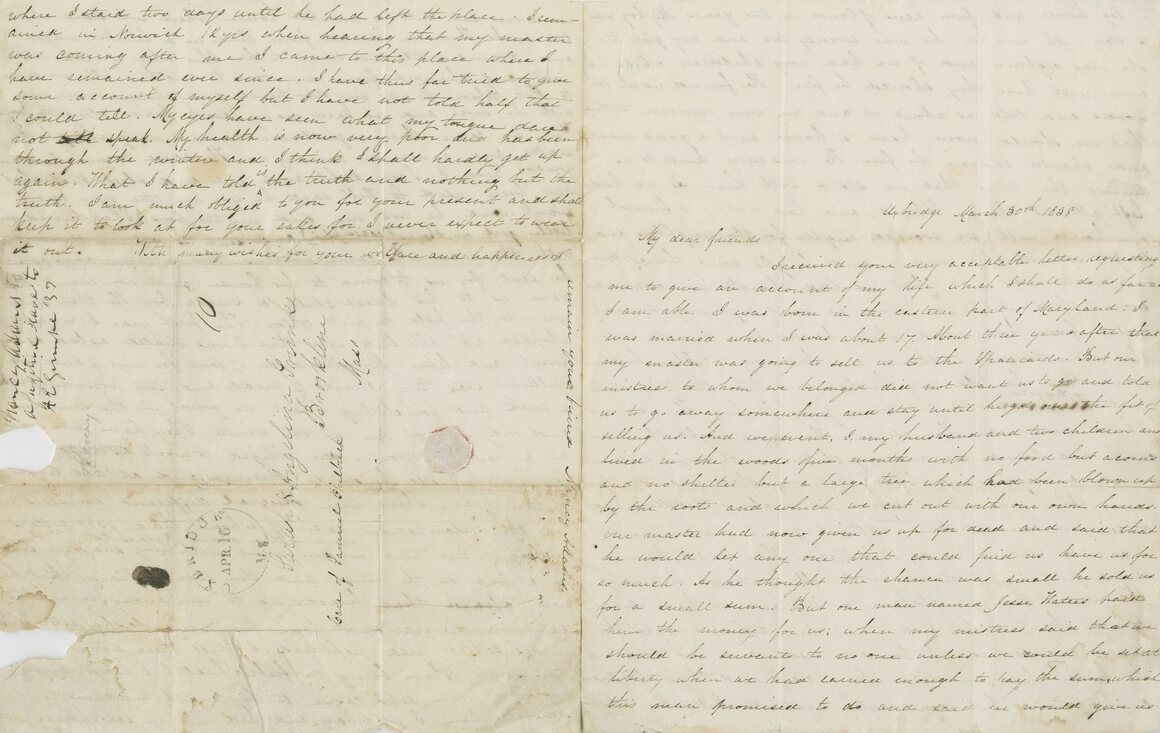
In 1982, surveyors from the Massachusetts Department of Public Works were mapping for a proposed expansion of Route 146 when they stumbled upon a handful of gravestones on a small, wooded hill. When archaeologists from Boston University came to take a look—suspecting the hill was an old Native American burial ground—they counted 16 fieldstones and one traditionally inscribed marble headstone, which lay face up and cracked under around an inch of soil, writes Ricardo J. Elia, an archaeologist at Boston University, in a 1992 paper published in the journal Markers. Reassembled, the headstone read “Mrs. Nancy Adams.” Her name, deeply etched, arced like a rainbow over her epitaph: “A respectable colored woman.”
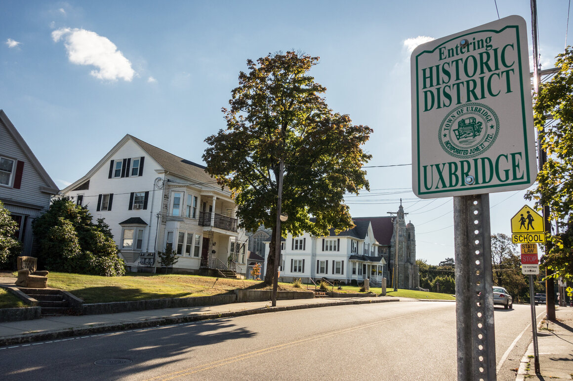
Adams, who died on June 6, 1859, had led a remarkable life. Over her 93 years, she escaped slavery three times—once in Maryland and twice in Connecticut—before settling in Uxbridge, Massachusetts, where she lived as a free woman for the last 21 years of her life. Her long-forgotten grave was rediscovered 37 years ago, but it’s just been during the last several years that the town of Uxbridge has worked to have her grave site accepted to the National Underground Railroad Network to Freedom, operated by the National Park Service. Earlier this month, it was accepted—immortalizing it among 650 sites critical to the history of resistance and escape, according to Diane Miller, the national program manager of the Network to Freedom. “Even if she escaped one time, we would have included her grave site,” Miller says. “But it’s remarkable that she had to escape three times.”
The town of Uxbridge sat at the crossroads of two historic highways that freedom-seekers followed, according to Susan Franz, a local councilmember. The Boston Post Road (now Hartford Avenue) connected Boston to Hartford, and intersected with the Great Road (now the less-elegant Route 146) from Worcester to Providence. Much of this history has vanished over time under pharmacies and highways. “Now, it’s a CVS,” Franz says. The town also boasted a robust community of Quakers, one of the first groups of white people in America to openly oppose slavery.
The discovery of Adams’s grave was not enough to reroute Route 146, so archaeologists moved all 32 bodies from the burial ground and, after examining them at Boston University, reburied 31 in what became the New Almshouse Cemetery on 80 Almshouse Road. (The final body, determined to be Native American, was returned to the Nipmuc people and reburied at their burial ground in Thompson, Connecticut.) Though given a proper reburial, Adams was once again largely forgotten, in a cemetery carved out of a patch of dogwood forest, accessible only by a small road off 146.
In 2018, a group of concerned citizen-historians approached Franz with an idea. They wanted to submit Adams’s grave site, along with 10 other sites in the town, for official recognition as part of the Network to Freedom. At the time, Franz knew little about Uxbridge’s involvement with the Underground Railroad. But Michael Potaski and other members of the Uxbridge Historical Commission had been researching Adams’s life for years, and had been buoyed by the discovery of a letter in a collection of abolitionist papers at the Clements Library at the University of Michigan, Franz says.
What little is known about the life of Nancy Adams, who was illiterate, comes from this letter, which she dictated and sent to abolitionist sisters Sarah and Angelina Grimké in 1838. It says she was born in eastern Maryland, was married at 17, and gave birth to two sons and one daughter. (Experts believe her grave stone, which states she was born in Louisiana, is incorrect.) When the slaveholder’s wife informed Adams that he planned to sell her family to the “Spaniards,” the letter continues, she and her family fled to the woods, where they lived in the hollow of a dead tree and ate acorns, Adams dictated. The family came out of hiding once it was promised they would be sold to a neighbor instead, who said that Adams could buy her freedom. But he broke this promise, and sold Adams and her three children down south, to Port Gibson, Mississippi.
Adams and her two sons—her daughter died on the journey—worked on a cotton plantation there. After 23 or 33 years of backbreaking labor (a hole in the letter obscures the precise span of time), she was sold again. Her new owner took her on a trip to Norwich, Connecticut, where she escaped again. She hid in an icehouse for two days until the slaveowner left town. She lived in Norwich for 12 years until she learned that the master knew where she was and planned to recapture her. So she fled one last time, to Uxbridge.
To Miller, Adams’s life is a remarkable encapsulation of the Underground Railroad because it demonstrates three common patterns for escape. First, Adams escaped to avoid being sold to the more-brutal plantations in the South. Second, she escaped opportunistically, while accompanying a slaveholder on a trip to a free state. Third, she ran away as a free person to ensure she would not be recaptured by a former owner. In her time overseeing the Network to Freedom, Miller has never seen any other individual’s story touch on all these narratives at once. “And the fact that she told her story herself?" she says. "That’s beautiful documentation."
That first-person history is exceedingly rare. Many narratives we have of formerly enslaved people are told from the perspectives of white people, most often white abolitionists, writes historian Cheryl LaRoche in Free Black Communities and the Underground Railroad: The Geography of Resistance. In 1895, Harvard historian Wilbur Siebert published The Underground Railroad From Slavery to Freedom, an expansive tome that spotlighted the role of benevolent white abolitionists who aided “fugitives.” The few narratives that come directly from formerly enslaved people became valuable tools of abolitionist propaganda—such as the Reverend William M. Mitchell’s The Underground Railroad—though these accounts were careful to obscure many details of successful escapes, so as not to tip off slaveholders, LaRoche writes.
Due to centuries of this focus, the history of the Underground Railroad is still being rewritten, Miller says. In 1998, the Network to Freedom was created to help establish a grassroots history of the Underground Railroad and allow local areas to highlight their roles in the freedom movement. Miller likens it to a crowdsourced public history project. “We’re uncovering this history from the ground up, as it’s a story you can’t appreciate from the top down,” she says. Communities submit sites, educational programs, and research facilities that are in any way associated with the Underground Railroad, which the Park Service vets for approval.
Uxbridge first submitted Adams’s grave along with 10 other sites, but this initial application was not approved, Franz says. The Park Service asked for more documentation, and luckily Adams was relatively easy to locate in the historic record, unlike many other formerly enslaved people, Franz says. Adams appeared in two censuses, which noted that she could not read or write and had no family. Then there was the letter, and the careful documentation of her grave and remains by Boston University archaeologists. She had been buried in a hexagonal yellow coffin made of pine and poplar, with a single brass hinge. Archaeologists discovered a mushroomy deformity in her hip that indicates she walked with a limp for many years.
According to a 2017 article in the Clements Library’s publication The Quarto, Adams’s name also appeared in William Lloyd Garrison’s abolitionist paper The Liberator twice—once for giving 25 cents to the Massachusetts Anti-Slavery Society and again for dictating a letter of gratitude for Garrison, along with “a very liberal supply of excellent cake,” he wrote.
If you know of a grave, monument, or building (even ones long gone) in your town that commemorates the Underground Railroad, the Park Service has a thorough list of guidelines to help fill out an application for recognition. There are even a few strategies for finding more information. “Were there Quakers or African Methodist Episcopals living in any houses, and did they leave correspondence or journals behind?” Miller suggests. “Once you have a profile of who these people were, then you can tease out their involvement.” In Uxbridge, Franz hopes next to unearth the story of Susan, a formerly enslaved person who enrolled in the local school at the age of 28 to learn how to read.
“I have thus far tried to give some account of myself but I have not told half that I could tell,” Adams dictated in her letter. “My eyes have seen what my tongue dares not speak.” Though Adams died in a poorhouse, the fact that she was buried with marble headstone indicates she was beloved by at least one member of the Uxbridge community, The Quarto notes. The shards of her original headstone now reside on the third floor of the Uxbridge Public Library, and a replica stands at the revived Almshouse Cemetery, just off Route 146.
The story of slavery does not begin with the Middle Passage.
From Tamale, Ghana’s third-largest city, it has taken almost four hours to get here, on a single-lane highway following the White Volta River. Usually it’s under three hours, past shea trees on the sparse, dry landscape, but this time political rallies and visiting dignitaries—including the country’s president—have meant detours and delays.
I’ve made this journey, as I have before, to visit Pikworo. As far as the eye can see, it’s all grass, clusters of stunted trees, rocks, and even more rocks—some brown, some gray like a London sky, pocked with holes and crevices.
The name translates to “rocky area” in Kaseena, the local language. The rocks and boulders are strewn across a sweeping green meadow, the sight of which, after so much brown, is startling. Though it is the rainy season, the morning drizzle is gone and the clouds have given way to sunshine. Nearby, in Nania, a tiny village two miles from Paga, a town on Ghana’s northern border with Burkina Faso, people go about their business—selling, cooking, building a life on the roadside, but this stunningly beautiful square mile of rocks and grass is eerily quiet, save for the chirping of birds.
A small group of visitors and I, led by a guide I’ve encountered on previous trips here, Aaron Azumah, 35, stroll around some of the boulders. Azumah leads us to a couple that have large oval holes in them, like giant thumbprints pressed into the rock. One rather large, rectangular one is filled with water from an underground spring. There's a sign: “Eating and Drinking Place for Slaves.” Some of the holes, we’re told, were dug by captives, who were forced to dig into the rock with their fingers to create “plates” where a local dish called tuo zafi, made from maize or millet, maybe with cassava, was served. They were eating from the rocks on which they were forced to stand.
All 2019, Ghana has been rolling out the red carpet to celebrities, political figures, and thousands of other members of the African diaspora for what it has termed the “Year of Return,” a 12-month commemoration of 400 years since ships first began to leave its shores, bound for the Americas, heavy with human cargo.
Most of those who have come have spent much of their time touring cities and visiting the castles built on the Atlantic Ocean. These were the last places that their ancestors saw of their homeland. Fewer visitors, however, continue on a reverse journey into the Ghanaian interior, to places such as Pikworo, where the insidious trade took root, where thousands died in the earliest stages of a journey that would, at every stage, claim thousands more lives: the trek to the coast, the slave markets, the Middle Passage, and then more markets, before they arrived at the plantations where those who survived were likely to spend the rest of their lives.
Making this journey in 2019 fills me with sadness. I am confronted with the harsh reality that for many, the brutality of the Atlantic slave trade commenced far away from the ocean, in tranquil villages like this one. Someone who had been captured into forced servitude in the interior might be granted freedom here, or marry someone free or even a royal, so that his descendants might end up free as well, or even in a position of power. But it was a different story for those who made it to the ocean: a generational sentence.
In Pikworo, next to the “dining rocks,” as they’re known, is a small field where a few villagers from Nania have come to give an impromptu musical demonstration. They bang smaller stones onto larger ones sonorously. Azumah explains that this is how the captives here made music, and the villagers boisterously sing traditional songs with roots going back hundreds of years. I don’t understand the words, but they’re supposed to be hopeful, optimistic, looking forward to brighter days. Yet they still call to mind dirges.
Farther afield there is a small rock that resembles a chair. The base is much slimmer than the top, and Azumah explains that this is not a natural occurrence, but rather that for decades ropes have dug into the rock. It’s the “Punishment Rock,” where enslaved people who tried to escape or otherwise misbehaved were lashed, seated, arms behind them, their heads tilted toward the sun.
These accounts aren’t written down in any kind of Western historical text, but rather have been passed down for generations. This is the way of history in this part of the world, where griots and elders can point out which tree or rock has a long story, or a famous or infamous person buried beneath it. It is not the same as historical canon, and therefore inspires some skepticism, but there’s a saying here that appears in various forms: “Until the lion has his historian, the hunter will always be a hero.”
From approximately 1804 until 1845, the local stories say, Pikworo was the base of a mounted slave raider referred to as Bagao, or “bush man,” and his small army. “He was a stranger to this community. When he was embarking on a journey in search of people to capture, he got to this part of the community and realized this particular site was the only place he could keep the slaves healthy and safe from being freed by the local people. It was so isolated,” says Azumah, who is from Nania and has been a guide here since 2006. “He was a black man who never told the people of Nania his origin. Or his name. I can’t tell you his real name, all that I know about is that he was called Bagao.” No one else in the village refers to him by any other name.
Bagao had two lieutenants. Locals are sure one was Burkinabe, and the other from much farther north in Mali. This was how the slave trade worked in the interior; men from elsewhere on the continent—or not so far away—staged raids to capture people from villages and bring them to places like this. In one spot at the edge of the meadow, where a cluster of trees provides soothing shade, there are about eight boulders, the tallest of which provides an unobstructed view for miles. Azumah explains that this was the watchtower used by Bagao and his men.
“So the three were having some kind of army that they would send to the communities including places afar, Niger, Benin. They were all invaders. Many young persons, males and females, strong men, they were at risk. Most times they were captured in the marketplaces, it could be any public gathering, even [in] funeral houses,” Azumah says. Raiders had been known to attack villages on horseback at night and take entire families, and then separate them for a long journey elsewhere, so the captives would be disoriented and lost, discouraging escape. It is said that Bagao brought thousands here to rest before they were forced to walk hundreds of miles down to the coast, bound for the slave ships.
“Some communities, to this day, don’t like seeing horses because that was what was used to raid them,” says James Suran-Era, a Tamale-based French teacher and expert on local traditions. This is one of those stories that seems to echo down through history—even to African Americans today.
This far north, the climate is particularly unforgiving. It’s closer to the Sahara than the sea. Many people died on their marches to and from here, others died after being tied up and left that way for days. There could be 200 people here at a time, and there wasn’t always enough food for them, so starvation loomed. Pikworo today has mass graves demarcated by circles of stones, and locals still bury their dead this way. All the known graves are off to a side of the camp, not far from the punishment area.
The seaside castles and fortresses hundreds of miles away clearly carry the architecture of Europe and the West, but up here the direct presence of Europeans is almost nil. “They never came to the northern part of the country because of the harsh weather conditions,” Azumah says. “It is our own people who started the trade here, being engineered by the Westerners. They provided all the apparatus—let me put it in that sense—though they themselves didn’t come here.”
Pikworo was actively used for about four decades, it is believed, and when the slave trade to the United States and South America slowed and stopped in the 19th century, its stories continued to be told. For over 15 years, the place has been open to visitors as an ecotourism site, though it can be difficult to find, at the end of a winding road away from the already remote village’s commercial strip.
The history is deep and the entrance fee modest, but the location and low profile mean that visitors are scarce. Many come only after hearing of the camp from people at the far more popular tourist site nearby, a pond that houses sacred, surprisingly docile crocodiles. Hundreds come through each year—and more this year—but tens of thousands visit the more famous slave dungeons in the seaside forts that have been the focus of many Year of Return events and publicity. Following this route from end to end is a way to understand that the story of slavery does not begin with the Middle Passage.
The few tourists around have made a great effort to be here. “I really wish more people would go,” says Christa Sanders, the director of Webster University’s Ghana campus. The Philadelphia native has made the long bus trip from Accra more than once, and routinely brings American visitors. “I think it should be a World Heritage site.
“It is critical to be able to go on that journey and be there and understand what the conditions were like before the slaves actually arrived at the final point before being transferred and transported on to the Americas via the Middle Passage,” she adds. “I think being able to hear the people from the local community, through reenacting the music and the songs that slaves at that time apparently sang—to listen to the lyrics—is powerful. You can actually visualize everything that was happening. It just opens up another very difficult, shocking, horrific period of this unfortunate time in history.”
Pikworo today is stunning, natural, seemingly out of time. But this time, like every time I have visited, chills run down my spine. The villagers there today may not have experienced these atrocities directly, but they carry their weight. They all know where the loathsome Bagao—who was killed by in nearby Navrongo—is buried.
Some of the captured individuals who survived Pikworo were auctioned on the spot, but almost all were shackled and forced to trek 200 miles to Salaga, a trading town that historically connected the kingdoms of the Sahel to the commerce of the coast. Kola nuts were a popular commodity there for a long time—to be joined by human lives as a tradable commodity.
In addition to the sun, heat, and lack of food, the captives were forced to carry cargo for their captors, and were at the mercy of bush animals—snakes, scorpions, and more. Some collected fruit or hunted bush meat, or ate whatever little the raiders left them. Many died en route.
Sanders says that it is important for people also to understand what the journey was like on foot. “What we’ve done in an air-conditioned coach bus, people were doing by foot and subjected to the worst of conditions by their own people, as well as the Europeans who came and worked with the locals to capture folks.”
“The journey ended somewhere in Elmina and the Cape Coast castles, but from here [Pikworo] they would move to Salaga slave market … then from that place to Assin Manso, where we have caves and slave wells, where they bathe them finally,” Azumah says.
The Hundred Wells of Salaga, based on a true story, is the seminal work by acclaimed Ghanaian writer Ayesha Harruna Attah. The novel explains how a bath in the pond was the first captives got since being kidnapped by mounted marauders. Then, Attah writes, they were smeared with dollops of shea butter to make them look healthier. There, their fates might diverge. Many would be shackled to trees, half-naked, while buyers haggled over them. Those too weak to be sold were left to die and be picked over by vultures. The buyers then took the others on another journey south—this one 400 more miles along forest paths—to the town of Assin Manso. Today it is a 12-hour road trip. Ghanaian authorities estimate the journey took two to three months on foot.
Assin Manso, like Pikworo, is just about empty. It’s 4 p.m., and the giant gates are locked. But soon enough a guide appears and opens up. Inside is a leafy, calm compound with an open lawn for meditation.
Outside of a bungalow that houses a tiny museum, offices, and restrooms, the compound is devoid of modern buildings. On the yellow walls are four-foot-high murals. One shows men in chains taking a bath in a stream. Another depicts the act of branding, and yet another features a person being punished by being tied up in the sun.
Just 35 miles from the “Big Water,” as the Atlantic Ocean was once known, this was one of the last places on the African mainland where people were auctioned before, mostly, being taken to the New World to be sold yet again. This was also one of the largest stopping points along the various routes used by slavers across the continent. Hundreds of thousands were auctioned here, though it is impossible to know an exact number.
The area around is green and lush—but it was like a dungeon, only out in the open and under the sun. There are two dignified, tiled tombs on the grounds. One is of a lady identified only as Crystal. She was returned from Jamaica. Next to her lies the remains of one Samuel Carson, of the United States. Both had been reinterred in 1998, two people from the diaspora, as a way to not let slavery have the last word.
For Fredara Mareva Hadley, 40, a Brooklyn resident who was a first-time visitor here in summer 2019, places like this—quiet and beautiful, but with so much horror just under the surface—have provided a deep awakening. Hadley had visited Ghana in 2018, but happily decided to come back again for the Year of Return. “I grew up hearing about the dungeons, so as much as anyone can emotionally prepare for witnessing that traumatic experience, I did,” she says. “But I didn’t know the history of Assin Manso, so the beauty of the forest and the sacred feeling there combined with the brutal things that happened there stayed with me.”
There is another gate within the grounds that leads through a horseshoe-shaped concrete entryway, on which “Welcome to Slave River” is painted in bold, black letters. It is yet another idyllic scene on the old slave trail, but as usual nothing is quite as it seems. My guide, Joshua Akabuatse Kwesi, is barely 30, but has an encyclopedic knowledge of the area and its lush vegetation. He leads the way down the path to the water, and tells me that it is the exact path that slaves were led along. Another concrete arch has “Last Bath” painted on it, meaning their last cleansing before the coast, the forts and castles, the white faces, the ships, and more. I’ve noticed as we walk that the path is lined with pineapple trees—and they turn out to be another damnable symbol, a thing of pleasure and sustenance perverted by the slave trade.
“They didn’t have landmarks such as churches and bus stops to really tell you where you were at a particular point so then they had to be innovative,” Kwesi says, of the raiders and their accomplices. “So they planted pineapples from the north to the south to serve as a guideposts. When you see a pineapple, you know you are on the path to Assin Manso. Pineapple trees have been here for over 400 years. As we approach the water, we see some villagers nearby. The river actually splits here and a smaller, shallower stream is denoted “Donkor Nsua,” or “Slave River.”
“This is where the captives took their bath. I really don’t feel comfortable calling them ‘slaves,’ I’d prefer ‘enslaved Africans’ or ‘ancestors.’ This is where they had their last bath before leaving the shores of our country,” says Kwesi. “This is more confined and they can keep an eye on you. You cannot escape.” The area is surrounded by trees on slightly higher ground, so visibility from above was very clear.
After weeks of trekking, the enslaved ancestors did not know that this would be the last place they would wash themselves on African soil. Kwesi explains that they were forced to bathe in the shallow rivulet in groups of 10, still in chains and shackles. “After your bath they made you go through rigorous exercises, such as jumping, to determine your strength. They opened your mouth with obscure devices to count your teeth to determine your age. They smeared you with palm oil or shea butter to make you look attractive and heal your bruises.” Kwesi says.
The juxtaposition of exercise, dental care, and beautification rituals with the literal commodification of humanity is striking.
When large groups visit, Kwesi says, sometimes guides allow them to walk into the waters for symbolic baths. Like most modern activities at these sites, it is a moment of contemplation and tranquility. There is a small museum exhibit, which includes chains and a ball shackle that were found in the river in 2005, and where guests are encouraged to write down their reactions and feelings on the wall. Like at Pikworo, there is a mass grave on site.
“It’s a different shock to the system than the castles because there is little at Assin Manso in terms of buildings and structure, so my mind was overtaken imagining the horrors the forest had witnessed,” Hadley, an ethnomusicologist, adds. The final indignity of Assin Manso, following the auction, was branding: hot iron pressed hard to the dark skin of the captives that would leave a mark to denote that the captive belonged to a particular group of European traders.
The souvenir vendors haven’t seen me in two years and they rejoice. I’ve visited this place, 98 easy miles from Accra along a seaside highway with spectacular views, many times over the years. Being a son of these shores, I consider Elmina Castle and the other fortifications on the Cape Coast a site of pilgrimage.
Unlike Pikworo or Assin Manso, this place has throngs of tourists and the men and women selling bracelets, chains, and other souvenirs come out to greet them, and me. But like those other places, this is a place of uncommon beauty and dark history. Pristine beaches and swaying coconut and palm trees mark the horizon, but they’re not why most people have come.
Rather, they most want to see the rooms and doors of “No Return,” the spaces and portals that led from these castles out to the docks, where people would be loaded onto ships. The first time that many visitors from the African diaspora will confront the most literal horrors of slavery in person will be at the very site where many of their ancestors saw their homeland for the last time.
Elmina is a fishing community that dates back to the 1300s. It is a Saturday afternoon and the boats have been pulled ashore, where their owners are tinkering with things on board. It’s hot and many have been working since dawn.
This all makes the mammoth castle—91,000 square feet—stand out more, still imposing, with fading white walls, yellow roofs, and cannons jutting out all over. It sits on just over two acres, has a moat around it, and has three levels, several courtyards and a smaller church/trading house inside.
The castle’s history of ownership reads as a history of the colonial exploitation of Africa by European powers. The World Heritage Site is 537 years old now. First it was controlled by the Portuguese, who had begun the slave trade in the area three decades earlier, for 155 years. Then it was the Dutch for 235 years, followed by 85 years of English control. For the last 62 years, however, it has belonged to Ghana, and the country has treated it both a tourist draw and a dark part of a vibrant country’s history.
“Elmina” is a corruption of Portuguese for “The Mine,” and here gold and spices from Africa were traded for gunpowder, guns, and more. The local name for the town was Anomansah, or “Inexhaustible Water.” The village is seaside but lagoons and creeks abound. Soon the human trade became increasingly profitable, and the dungeons became a hellish stop—in a long line of them—before the ships carried enslaved Africans to the Americas. There is no evidence that anything other than people were stored in the dungeons.
And that’s where most tours of the castles begin, in the dungeons. Then they go to the churches, the courtyards, the doors and staircases where women were brought to European masters’ bedrooms to be raped—the well-lit and airy quarters where those administrators held court. (Today these places feel ghastly and haunted. There had been joy here among certain people, but it’s hard to imagine.)
Many visitors are then shown the courtyard where stubborn slave women were left out in the sun, chained to cannonballs, as an example to other African women who refused. Some women who were repeatedly raped got pregnant, and their children were raised and educated in the castle, where they were taught to be interpreters. At some point some stone houses were built for the mistresses and their children. Today, in Elmina, many Ghanaian families have surnames such as Vroom, DaCosta, Yankson, and Pieterson.
As probably the most-visited site in Ghana related to the slave trade, Elmina Castle sees tens of thousands visitors yearly, and many more this year, it seems. In the dungeons, chatter among visitors soon gives way to gasps, reflection, and ultimately stunned silence.
I walk through these spaces with Ato Ashun, author of Elmina: The Castles & The Slave Trade, the curator for the 42 forts and castles along the coast that were used in the slave trade. “Women and children were chained together for months with no other place to menstruate or use the toilet,” Ashun says. “In the life of a captive, life never got better.”
Somehow, the smell seems to remain, a powerful stench in the female dungeons that knocks visitors for a loop. On average, according to Ashun, captives spent two months chained in these dungeons. Every time that I’ve been there, on average about once a year for the last decade, the stench is the same.
The indignities didn’t stop there. In the female areas, more rapes, assaults, and vicious beatings by European soldiers were commonplace. In the male holding areas, men and boys were chained together. Resistance was not tolerated and examples were made of the stubborn. Outside of beatings, they could be isolated in a dark cell with just a sliver of light for weeks. If someone died in the dungeon, his body would be left with the living for a while, Ashun says.
We see groups visiting from the United States, and another from South Africa. There are a lot of them, and for someone who has visited this place many times, it is thrilling to see so many people experiencing it. It’s an international group with a diversity of races. All are sobered by the experience.
The entire trek through the country from Pikworo and Salaga to Assin Manso took the captives, who survived against all odds, to a singular point—a “Door of No Return.” It is actually a tiny gate, barely large enough for the average person today to squeeze through.
The trek and the months in the dungeons, awaiting the boats, had weakened the enslaved people. Those who made it here were so gaunt and reduced that they could pass through the gate easily. They were then put on small boats that carried them to the ships.
Today, the ocean has receded and the door opens to nothing. Some visitors poke their heads out and quickly pull back in. It’s an extremely dark room, empty save for bouquets of flowers or liquor bottles brought as inadequate memorials, but the place feels stifling. The most striking visual difference between then and now is the visitors I see around me, the descendants of people who passed through places like this. The guides say that most respect a moment of silence here, and then vow “Never Again.” It’s barely even that long before most who visit here just want to get out.
You can join the conversation about this and other stories in the Atlas Obscura Community Forums.
Yuncheng Lake is one of the country's oldest salt-production sites.
In summer, it colors the landscape blood crimson, glossy green, and glassy indigo. In winter, it becomes crystalline, ice-white, and sculptural. Wars have been fought over it, gods have guarded it, and its contents fill plates and tombs. It’s not a landscape in a fantasy novel. It’s Northern China’s Yuncheng Salt Lake, the world’s third-largest sodium sulfate inland lake and one of China’s most important historical sources of salt.
Located in Northern China’s Shanxi Province, the lake has provided salt to locals for thousands of years. Historians date the first salt mining to at least 4,000 years ago, and human remains from around the lake hint at even earlier salt harvesting. The lake accounted for a quarter of China’s total salt production from the seventh to 10th century, making Yuncheng City an important administrative center, and inspiring a series of wars for control of the lake and its lucrative, salty haul. Locals traditionally worshipped a range of salt deities in nearby temples.
Considering salt’s pivotal role in the development of Chinese cuisines—salt-curing is a common food-preservation method, and salt-cured foods have been found in historic burials—this reverence makes sense. But there’s another reason locals and visitors alike have long been awed by the body of water dubbed “The Dead Sea of China.” It’s hauntingly beautiful.
In summer, the lake looks like a box of jewels spilled by a giant. This is due to blooms of the algae Dunaliella Salina, a uniquely salt-tolerant species that appears blue and green in water but can turn bright crimson in high salinity and heat. From above, these colors cover the landscape like a luminous quilt, divided by the tiny asphalt-grey lines of salt ridges and highways. D. Salina is so vibrant that it’s actually used as an industrial-cosmetics coloring.
In winter, these lush, saturated colors yield to a glistening, white otherworldliness, with crystalline structures rising like ice sculptures from the lake’s surface. These coral-like structures are actually mirabilite, also called Glauber’s salt, a kind of sodium sulfite that grows thick, quartz-like crystals in temperatures below negative-five-degrees Celsius.
Each summer and winter, visitors, motivated by a love of both natural beauty and the perfect Instagram shot, come to witness this entrancingly alien landscape. But there may be trouble brewing beneath the lake’s bright surface. Unlike the actual Dead Sea, which is filled with chloride and thus hostile to life, Yuncheng’s salt lake is sulfate-based, meaning it nurtures a rich ecosystem including birds and flamingos as pink as the lake’s surface. Algal blooms like the ones that paint the lake in summer can signify organic pollution, and often block needed oxygen and sunlight from reaching other lake life.
Local leaders have moved to address these environmental concerns and turn the lake into a more sustainable tourism destination. Starting in the 1980s, producers pivoted toward harvesting salt for industrial rather than culinary purposes. Since then, however, the area's traditional salt-harvesting methods have been named part of Shanxi’s official intangible cultural heritage. An influx of tourism means a potential for revival. While a cleaner lake may mean saying goodbye to some of those more luminous algal hues, the restoration of wildlife and local foodways would be just as wondrous.
Researchers have found Pleistocene-era proof of a human, mammoth, and ground sloth trundling along.
Today, White Sands National Monument in New Mexico is studded with dune fields, which are constantly being shuffled and sculpted by the wind. Visitors can hike across the soaring, powdery mounds of gypsum, or even barrel down them on a sled. The dunes seem to go on forever: They stretch for hundreds of square miles, and as the sand whips past, it’s easy to imagine an infinity of white, rolling humps.
At the end of the last Ice Age, it looked a lot different. Neighboring Lake Otero was beginning to evaporate, leaving behind selenite crystals that eroded into the sands of Alkali Flat. In the waning days of the Pleistocene, a human, a ground sloth, and a mammoth trudged across the eastern side of that disappearing lake. Now, well over 10,000 years later, researchers from Cornell University, Bournemouth University, and the National Park Service are using ground-penetrating radar to study the tracks they left behind.
An animal can only die once, and when it does, there’s a vanishingly slim chance that it will become a fossil: Far, far more often than not, an animal’s carcass will decay and rot until there’s little proof that it ever existed at all. While it’s alive, though, a creature can stamp proof of itself all across the landscape. Ichnology is the study of those preserved tracks, burrows, and other “trace fossils”—and it's a way for researchers to visualize an animal’s behavior and biomechanics without a body in sight.
Like any other fossils, trace fossils owe their existence to a bit of luck. “You need a surface that is soft enough to deform and leave an imprint, which is true for sand and mud,” says Douglas Jerolmack, a geophysicist at the University of Pennsylvania who has worked extensively in White Sands but was not involved in this current research. “To preserve it, you also need the surface to ‘lock in’ that imprint somehow,” he adds. A track might be submerged by other sediment faster than wind or water can obliterate it, for instance, or it may be cemented in place. Jerolmack suspects that’s what happened in White Sands. “The upwelling of salt-saturated groundwater in the arid environment there leads to precipitation of salt that builds little bridges among sand grains and binds them together,” he says.
Researchers have long known about the prehistoric tracks scattered throughout White Sands, but it’s hard to study them up close. Though there might be as many as millions of trace fossil tracks in the area, “most of them, you’ll only see intermittently or not at all,” explains Thomas Urban, a research scientist at Cornell University and the lead author of the team’s new paper in the journal Scientific Reports. The tracks are often easiest to glimpse right after a rain, or when sunlight rakes across a salt crust just so. They’re also spectral—visible one afternoon, and gone the next. When they were completing their field work, Urban and his collaborators stumbled across sloth prints one day, only to find them covered up again when they returned. “That’s why we call them ‘ghost tracks,’” Urban says.
It’s also highly likely that, over the years, humans have spotted the ancient tracks left by mammoths, ground sloths, canids, felids, bovids, and camelids, and believed them to be something else. To the casual observer, mammoth tracks—which can be the size of a trash-can lid—“just look like a big round thing,” Urban says. Some passersby probably figured they were puddles that had dried a little strangely on the sand; others have thought that the prints were proof that a giant human once lumbered across the landscape.
In 1932, a government trapper named Ellis Wright rounded up a group of brave souls to go investigate 13 tracks “of unbelievable size” that he’d noticed imprinted in gypsum. The footprints were gargantuan—22 inches long and eight or 10 inches wide, far bigger than any man’s he had ever seen. Still, the group concluded that the tracks had been left by a human, according to a 1938 pamphlet. “There was not one in the group who cared to venture a guess as to when the tracks were made or how they became of their tremendous size,” the pamphlet declared. (The prints Wright described “closely match” the giant sloth ground prints found in White Sands today, says David Bustos, the monument’s resource program manager.)
Urban and his collaborators wanted to learn as much as they could about the area’s trace fossils without digging them up. That’s partly because once the ground is disturbed, it’s never the same. “Excavating a site alters it permanently, which makes it difficult for others to study in the future,” says Taylor Perron, a geologist at the Massachusetts Institute of Technology who was not involved in this research. “There is also a risk that you will miss something important in the material you remove,” Perron adds. Plus, even if Urban and company were willing to plunge shovels into the soft sediment, the task would be too huge. “There are just too many of them,” Urban says. “It would be centuries of work.”
Ground-penetrating radar machines, which look like a cross between a metal detector and a vacuum cleaner, are a lot quicker. Urban’s team set down a foam pad to cushion the sediment, and then rolled their machine along it, in straight lines spaced a few inches apart. “All I have to do is walk,” Urban says. The wheel is hooked up to an odometer, and the machine sends a pulse into the ground at regular intervals. The team can tackle a site in just a few hours, compared to the months it might take to excavate by hand.
The data that comes back are traces, or series of oscillating pulses. A bunch of those form radargrams, which look like cross-sections; from there, the researchers interpolate in between them to make a 3D image that helps them understand what’s going on beneath the surface.
The radar can reveal the size, shape, and direction of tracks, as well as the depth of the compressed sediment beneath it. That 3D image of the ground beneath the footprints “would be difficult to study through excavation—and you would have to dig up the footprints completely to get at the material underneath,” Perron says. Looking at the compression can help researchers piece together information about biomechanics, including how the creatures distributed their body weight as they strode along.
The tracks also highlight chance encounters in the prehistoric neighborhood. At the site where they did their fieldwork for the Scientific Reports paper, Urban and his colleagues found that a Pleistocene-era human had wandered for about half a mile, heading north. Later, a mammoth trundled through from the side, and squished that footprint. Eventually, a human—maybe the same one—ventured south. “The mammoth messes up the human footprint, and then a human turns around and messes up the mammoth print,” Urban says.
After comparing the radar data to an excavated site, the researchers found that the machine was able to detect almost all of the tracks—and revealed more than they expected to encounter. Each time the team has used the machine in an area where trace fossils have been spotted, “there are always more than we thought there were,” Urban says. So far, the team has surveyed between 25 and 30 sites around White Sands, and they’re still interpreting their data.
For the average visitor, “ghost prints” are still elusive. The trackways aren’t accessible to the public, and the researchers keep the exact locations secret, to minimize damage to the fossils. But there are a few prints on display at the visitor center, says Bustos, the resource program manager, and the park is working on 3D models of the trace fossils that can be accessed digitally from anywhere. Beneath that ancient sand, there are many more stories to tell.
Formed by dripping water over thousands of years, the rocky formations point to ancient monsoons.
Long before the stalagmites sat on Ian Orland’s desk in Madison, Wisconsin, they jutted up from the floor the Soreq Cave in Israel's Judean Hills, 18 miles west of Jerusalem. There, in the dripping darkness, the mounds of calcite were standing witness to the world outside.
When researchers want to learn about historic climates, they often go deep—down into Antarctic ice, for instance, or through the centers of centuries-old trees. They sometimes go into caves, too, because stalagmites and stalactites preserve clues to long-ago rainfall. Along with several collaborators from the University of Wisconsin-Madison and the Geological Survey of Israel, Orland, a geoscientist now at the Wisconsin Geological and Natural History Survey, recently studied a few of the lumpy rock formations from Soreq Cave to learn about the ancient climate of the Levant.
As rainwater trickles through cracks and into caves, it mingles with carbon dioxide and forms carbonic acid, and picks up dissolved limestone and dolomite along the way. As the carbon dioxide gas is released from the mineral-laden water, it forms a stony deposit called calcite, which collects on ceilings, walls, and floors. Over long, long periods of time, these trickles leave three-dimensional tracks—stalagmites and stalactites, which can take all sorts of flowing forms. The stone of these often-beautifulformations contains oxygen isotopes that can tell a lot about the water that formed them—where it originated, how long it traveled as vapor, and whether it came down in a light drizzle or a torrential downpour. Those chemical signals “are preserved in the stalagmite as it grows and are frozen in there forever, for all intents and purposes,” Orland says. “The amount of information contained within them is pretty remarkable.”
The stalagmites that Orland’s team studied had been collected a few decades ago by collaborators in Israel. They are just a few inches across, but they hold several thousand years’ worth of ancient data. One grew between 125,000 years ago and 115,000 years ago, and another between 115,000 thousand years ago and 105,000 years ago. (Stalactites hold climate data, too, but stalagmites are easier to study, Orland says. They always form like a pile of dirty laundry, with the oldest stuff down at the bottom.)
Today, Israel’s summers are “bone dry,” Orland says. But his collaborator, Feng He, a scientist at the Nelson Institute for Environmental Studies Center for Climatic Research at the University of Wisconsin-Madison, had been working on historic climate models that suggest that, at the time the stalagmites formed, summers in the Levant were a lot wetter and marked by monsoon conditions that resemble winter rains, and today are seen much farther south. The model gave Orland, He, and their collaborators “a hypothesis we could test in the cave,” Orland says. If summer had indeed been wetter, Orland suspected, the team might find fewer seasonal ups and downs in the oxygen isotopes. Summer would have looked, chemically, like winter.
To study stalagmites, scientists cut them into slices, like the trunk of a tree, so they can see the rings or layers that built up over time. After the chunks were polished with a diamond-studded pad, Orland’s team analyzed the buffed bands for two oxygen isotopes: lighter oxygen-16, which today accumulates during the wet winter, and the heavier oxygen-18. As they describe in a recent paper in the journal Proceedings of the National Academy of Sciences, they found what they thought they might: consistency. They saw proof of wetter summers, preserved in rock.
Orland’s team wonders if wetter summers may have emboldened people to migrate across the Levant. If so, there are likely many other clues to look for. “If monsoon rains really are reaching this area like we suggest, you would expect that there might be changes in the vegetation during that time period that might appear or be recorded in pollen records,” Orland says. He hopes that other researchers will find hints of soggy summer days in other records, and across the region. “Not necessarily more stalagmites.”
Once, Americans rode the rails for charbroiled steak, golden French toast, and prunes.
Ira Silverman was always on the go. In the late 1960s, the train enthusiast enrolled in Northwestern University’s Transportation Center in Evanston, near the great national rail hub of Chicago. This proximity gave young Silverman and his classmates opportunities for research, adventure, and unparalleled feasting.
As graduate students in railroad transport, they regularly hopped on privately operated railroads that carried them to distant cities. But they always made sure to catch the evening return train, so that they could relish meals in a dining car while watching the shifting American landscape. With standard fare such as charbroiled steak, lamb chops, and fresh filet of sole, the experience probably far surpassed eating on campus.
Silverman, now 73, clearly cherished these memories. He began collecting dining car menus, eventually amassing an archive of 238 menus and related pamphlets. After a long career in transit, he donated the collection to his alma mater’s Transportation Library, which recently digitized it in its entirety. The pages (almost all, impressively, unstained) offer a mouthwatering journey down the rabbit hole of deluxe railroad dining, when well-heeled travelers expected to sit at tables draped in white linen and indulge in outstanding meals plated on china.
With Amtrak’s announcement that it is gradually eliminating the traditional dining car on its routes as a cost-saving measure, that experience—already simplified over the decades—might become a thing of the past. It’s part of a long slide that’s seen dining cars say farewell to fresh French toast, a perennial train favorite across the country, and hello to prepackaged chicken fettuccini.
“The mid-20th century seems to have been a golden age of railroad dining,” says Rachel Cole, Northwestern University’s Transportation Librarian. “It was never something that railroads profited on, but they used it to compete against each other and attract passengers. They took a lot of pride in offering selections that would be rivaled in restaurants.”
Some railroads would entice riders to the dining car with signature dishes. The Northern Pacific advertised its Great Baked Potato, a monstrous spud that could weigh anywhere between two to five pounds. It was served with a Northern Pacific-branded spoon and an appropriately sized butter pat. The Baltimore & Ohio Railroad offered a popular “Help Yourself” salad, drizzled with Catalina dressing and blue cheese that a server would lug around in a huge bowl at dinner. Aboard a Gulf, Mobile & Ohio train, passengers seeking extra extravagance could order a special chicken sandwich embellished with hard-boiled egg, Thousand Island dressing, and caviar. The curious combo cost $2.25, or about $18.40 in today’s dollars.
Then there were the drinks. Libations ranged from a classic martini to a Rob Roy to a complimentary bottle of rosé with dinner on the Penn Central. The Southern Pacific hosted a “Cocktail Time” with free hors d’oeuvres (plus a “Coffee Hour” in its lounge) which it plugged as “an excellent opportunity to get together for an enjoyable interlude.” A New York, New Haven, and Hartford menu teased: “For a real appetizer, enjoy antique bourbon on the rocks.” To accompany their chosen booze, adults could also purchase cigarettes, cigars, and playing cards. Unsurprisingly, aspirin and Alka-Seltzer were often included on the bill of fare.
The Ira Silverman Railroad Menu Collection is particularly rich in menus from 1960 to 1971, the final decade of privately operated long-distance train travel in America. By then, people had been devouring freshly prepped meals aboard trains for nearly a century. It all started in 1868, when George Pullman’s Palace Car Company introduced a railroad car with a small kitchen and two dining areas. Railroad dining reached its pinnacle in 1930, as author James D. Porterfield notes in Dining by Rail: The History and Recipes of America’s Golden Age of Railroad Cuisine. That year, 1,732 dining cars were registered with the Interstate Commerce Commission, a former government agency that regulated the services of transportation carriers.
The earliest menu Silverman acquired was once perused by passengers aboard the famed 20th Century Limited train, which traveled between New York City and Chicago. It dates to 1939, one year after luxury Art Deco cars by industrial designer Henry Dreyfuss were added to the route. The train, majestic and futuristic, adorns the menu’s front cover; the back features a map illustrating connections from Grand Central Terminal to the World’s Fair at Flushing Meadows. Inside, an array of classy options speaks to an exemplary railroad dining service. Diners could opt for an opulent six-course dinner featuring English loin chop with kidney and fresh mushrooms, or exercise more freedom with the à la carte menu, which boasted genuine Russian caviar on toast and grilled French sardines. (Cary Grant, playing an adman in Alfred Hitchcock’s North by Northwest, orders a brook trout with his Gibson on the 20th Century Limited.)
“You come across four- or five-course dinners pretty often,” Cole says. “Jellied, mid-century things also come up very often.” Among the smaller plates on the 1939 menu, for instance, are a cup of jellied consommé and jellied tomato madrilene—a cold tomato-based soup.
Many common railroad dishes would be considered offbeat to the 21st-century Amtrak rider. Long gone are the days when Welsh rarebit (fancy cheese on toast), kippered herring with eggs, and preserved figs were de rigueur. Plus, prunes often popped up, prepped in myriad ways: juiced, steamed, stewed with cream, cooked in syrup, and, for kids aboard the Union Pacific, puréed. Minors on that fleet would perhaps have preferred to slurp down a milkshake—available in chocolate, strawberry, or pineapple—or save room for freshly baked pie.
As Cole notes, “Children's dining experiences were more sophisticated than we might imagine today.” She points out that menus for those age 12 and under offered much more than peanut butter and jelly sandwiches, instead featuring items such as grilled lamb chops, roast beef, and seasonal fish.
Gene Arenson, a self-described “lifelong railroad fan and advocate,” still remembers the first dining car meal he had, when he was a high school student. “It was a nice steak dinner with a baked potato and dessert, on the San Francisco Zephyr from Chicago to San Francisco in 1974,” he says. “In fact, I remember the server. His name was Ernie—quite a colorful guy. He took excellent service. But to be able to look out the window while you’re eating … you can’t describe it.”
This past August, Arenson launched a Change.org petition urging Amtrak and Congress to keep traditional dining car service on all long-distance trains. The railroad service, which on October 1 began cutting the amenity from long-distance routes east of the Mississippi River, replaced it with a “flexible dining menu” with ready-to-serve meals for sleeper car customers. The change, according to Amtrak, will save the company $2 million annually. Plus, as its executives have argued, millennials apparently aren’t comfortable with the idea of sharing tables with strangers.
“To me, that's just malarkey,” Arenson says. “I’ve spoken to other people, and they’ve all agreed that that’s not an issue.” The new meals, he adds, are “glorified TV dinners. They look sloppy, never appetizing, and loaded with fat and sodium. Meanwhile, coach passengers are now at the mercy of the café car, which is a glorified 7-Eleven.”
Many railroad advocates, he adds, fear that the cuts will eventually roll over onto the West Coast trains, too. Arenson has since been working with congressional representatives and the National Association of Railroad Passengers to call on Amtrak to rethink its strategy. “People are expecting to get what they pay for,” he says. With him are 146,647 signatories so far, many of whom have left comments describing the timeless romance of the dining car that draws them to train travel.
As for Amtrak’s claim that millennials are killing the dining car, Cole adds that it’s worth remembering that Silverman started collecting menus when he was a young person. “He took train rides just to enjoy the dining car experience,” she says. “I think that continues today. There are a lot of young people who enjoy that experience as much as he did.”
“If I could, I would go without shoes here, because it’s a holy place,” says a guide to the ancient site.
Meky Mohamed Farhoud grew up in a small village called Qawarish on the edge of the Tigris River, among pomegranate, orange, and date trees. The village is just steps away from the ruins of ancient Babylon, the Mesopotamian kingdom that Hammurabi helped build into one of the world’s largest cities. As a child, Farhoud played soccer in fields studded with ceramic shards and bricks from long ago. “I had a golden childhood,” he says.
But Qawarish’s famed location ultimately doomed it. In the 1980s, during the Iran-Iraq War, Saddam Hussein became obsessed with the Babylonian ruler Nebuchadnezzar, who is notorious for waging bloody wars to seize large swaths of current-day Iran and Israel. Saddam saw himself as a modern reincarnation of Nebuchadnezzar, and to prove it, he spent millions building a massive reconstruction of Babylon.
Saddam wanted a palace to overlook his works, and Qawarish had the unfortunate luck of standing in the perfect location. In 1986, Saddam’s workers blasted away Farhoud’s village and built an artificial hill in its place. Today, Saddam’s palace upon a hill stands on the same site where Farhoud went to school; from it, you can see reconstructed walls and mazes with perfect clarity. That beautiful view came at an immense cost. “I cried,” remembers Farhoud. “At that time, I felt like the village was a member of my family. I loved it.”
Nowadays, Farhoud waits daily outside the entrance to Babylon, where he works as a tour guide for hundreds of visitors from all over the globe. The gate, made from bright-blue bricks and polished off with a gold overlay, looks like it could have been transplanted from Vegas, or Disneyland’s Cinderella Castle. Farhoud is now in his mid-50s, with a face worn by 25 years of working under the unforgiving sun. He has seen Babylon transform from an archeological site to the jewel of Saddam’s vanity projects—and then to an occupied territory under the Americans. Today, it seems to fall between picnic site and abandoned theme park. Teenagers wander among Saddam-era walls and Nebuchadnezzar-era bricks. They smoke cigarettes, steal kisses, and blast music from their speakers. The site belongs to a new generation now.
The ruins of Babylon, also known as Babel, date back over 3,000 years. The world’s first-known civil code was written here; Alexander the Great died here; countless Bible stories take place here. It holds an imagined as well as real presence in many people’s minds, which may be why so many rulers have tried to build their dreams here.
When Saddam invaded Iran in 1980, the country was still reeling from the 1979 revolution, and he believed a few weeks of fighting would solidify his position as the leader of a unified pan-Arabist dream. It proved to be one of the greatest political errors of his career. Farhoud, like many other Iraqis, was conscripted. Within a few years, Iran had not only retaken its territory, but also launched an offensive against Iraq. By 1983, the pan-Arabist dream was drawing thin. The war showed no sign of ending, and Iraqis did not understand why they were fighting in a conflict they never asked for.
To fuel support for the battle, Saddam turned increasingly turned to grand nationalist building projects. That was when he ordered the reconstruction of Babylon.
“Babylon is neither Islamic nor Arab—it is obviously deeply pre-Islamic,” says says Kanan Makiya, an Iraqi author and professor at Brandeis University who has written a book on Saddam’s building projects. “In celebrating Babylon and reconstructing the city of Babylon, what one is doing is essentially calling upon the idea of Iraq—not the idea of Arabism, or the idea of Baghdad as the spearhead of a new pan-Arabism in the region, or Islamism, but Iraq.”
Saddam siphoned millions into the rebuilding, and pushed to have the reconstruction built on the foundations of the original site. The project was not only nationalistic, but also narcissistic. “There was megalomania involved in that,” says Makiya. “Saddam wanted every Iraqi to know that he rebuilt Babylon. The point is that it's not just an archaeological reconstruction of the city of Babylon for the sake of science and history and the past. It's an idealization of that history for the purposes of the cementing of the legitimacy of the regime's presence.”
His palace at Babylon is the clearest example of his hubris. It’s carved with Arabic calligraphy that at first glance resembles religious iconography, but upon closer appraisal reveals itself to be Saddam Hussein’s initials. Brutalist, hyper-realist reliefs depict him leading soldiers on the battlefield; the ceilings are painted with symbols of Iraqi civilization, ranging from Babylonian lions to towers that Saddam built in Baghdad.
When Saddam heard that Nebuchadnezzar had stamped the bricks of ancient Babylon with his name and titles, he ordered that the reconstruction mimic this practice. To this day, in the maze behind the Southern Palace, scores of bricks are stamped with a declaration: “In the reign of the victorious Saddam Hussein, the president of the Republic, may God keep him the guardian of the great Iraq and the renovator of its renaissance and the builder of its great civilization, the rebuilding of the great city of Babylon was done in 1987.”
The war killed hundreds of thousands of soldiers. When it ended in 1988, under a ceasefire brokered by the United Nations, Farhoud returned to a totally different Babylon than the one he remembered. Looking at the bright new cement bricks, he was aghast. “Saddam wanted to be like a king,” he says. “The building was not right.”
But Farhoud still loved Babylon. It was still the place where his father and grandfather had worked before him. He took up his job as a tour guide and welcomed crowds of Iraqi tourists, who marveled at what Saddam had built.
When President Bush ordered U.S. forces to invade Iraq in 2003, they occupied Babylon and turned Saddam’s castle into their command center. Their graffiti remains on the walls: notes of longing about faraway loved ones, reminders of soldierly protocol. The military also caused immense damage to the site, looting precious artifacts and running tanks over ancient ruins. Farhoud remembers that time with fury. “I would not sell a single piece for a $1,000,” he says, “Babel is more precious to me to me than my children.”
Farhoud says that the U.S. military arrested him in a broad sweep of Iraqi civilians and held him for two weeks in a sunless room. “I don’t remember the number of days in prison. I suffered from torture and I still feel pain today in my chest, because of the beatings from the Polish and American soldiers,” he says. Poland was one of only three nations whose soldiers joined U.S. forces in Iraq, as part of the so-called “coalition of the willing.”
But Farhoud doesn’t like to remember those days. Instead, he likes to tell stories of good days in Babylon. He met his wife within its walls, when she came for a visit in 1999. She was taking a tour with her family, and he says that as soon as he saw her, his heart started beating quickly and he knew he wanted to become close to her. His daughters, inspired by the site, are now studying archaeology and history at the University of Babylon. He loves Babylon with a fervor that burns through any dark memories he has of the place. “If I could, I would go without shoes here, because it’s a holy place,” he says.
Over 15 years after Saddam’s fall from power, his palatial tribute to the emperor has become a ghostly shell. Broken glass and graffiti are scattered through the once-grand palace halls. Teenagers and families smoke shisha and listen to music on Saddam’s vast balconies, overlooking the mind-boggling spread of Babylon.
From a balcony, Farhoud points out his favorite grove of date trees. He tells the story of the time he met Saddam in an entrance hall. He points out how the southern walls were constructed to confuse invaders. For all of the painful memories, he loves the city with naked affection. “I love Babel, and feel that Babel is like my father, mother, wife, brother, and sister,” he says.
In front of him stretches a vast maze, its walls engraved with the name of the ruler who once cast a shadow over this land–a man with the power to twist Farhoud’s home into a grand palace. He still loves this place. It history is a poignant reminder that nothing built by men can last forever.
Properly executed, statecraft involves tons and tons of paperwork: documents for correspondence, for record keeping, for codifying laws, and, occasionally, for translating the work of early Roman historians. At least that’s what someone in the court of Elizabeth I of England was doing in the late 16th century—specifically a translation of the first book of Tacitus’s Annals from Latin to English—before the work ended up among the royal paperwork. The text was later revised by a second, sloppier hand. Now an article in the journal Review of English Studies suggests that the mystery editor of the manuscript, which has resided at London’s Lambeth Palace Library for 400 years, was none other than the Virgin Queen herself.
“There’s this chap called John Clapham, who produces a history of Elizabeth’s reign,” says John-Mark Philo, a fellow at Harvard University’s Center for Italian Renaissance Studies who identified the manuscript’s editor while on a fellowship with the University of East Anglia. “He’s Elizabeth’s contemporary, and he mentions some translation of Tacitus’s Annals.... I certainly didn’t expect it to be edited by the queen.”
Tacitus’s work, written around the turn of the first century, found renewed popularity in Renaissance Europe. In the manuscript found in the library in Lambeth, Tacitus describes the peaceful period of the Roman Empire under Augustus. The work is penned in a neat, consistent, impressively legible italic across 34 pages. A few words throughout the work are struck through, with hasty corrections squeezed in above. The edits are peppered with royal terms such as “sovereign” and “reign,” nodding toward a monarchical perspective. But these word choices weren’t enough to identify the editing as Elizabeth’s—that took a modern understanding of old handwriting. In comparison with the royal scribe’s tidy hand, the edits are formed of a rather distinctive chicken scratch.
“The queen, and only the queen, uses this combination of an ‘M’ and an ‘E’—she’s almost making shorthand for ‘ME,’" Philo says. “It’s stuff like that in paleography. If it’s that weird, that odd, you’ve struck gold.”
The manuscript indicates that scribes serving the English queen likely had a multitude of duties. “The same scribe could be called in at one moment to copy an official letter concerning pressing state business,” Philo says, “and at another, the queen’s private meditation on Roman history.”
The manuscript was written on paper stock unique to the Elizabethan court. It was also watermarked with royal insignias that date the work to the final decade of the 16th century, when the queen was in her 60s. Scholars have previously taken note of how the monarch’s handwriting changed over the years. “When she’s a child, her handwriting is this absolutely exquisite italic,” Philo says. “As her reign progresses, you can see it falling apart. By the 1590s, it is wonderfully, fantastically, messy.”
The translation now resides in Lambeth Palace—directly across the Thames from the queen’s resting place in Westminster Abbey—alongside troves of other documents from her reign. (It is also the official London residence of the Archbishop of Canterbury.)
“What I hadn’t appreciated before I started working on this translation is that Lambeth Palace hosts one of the largest collections of state papers from the Elizabethan era,” Philo says. “You think of the National Archives and the British Library, but actually Lambeth Palace, specifically for Elizabeth’s reign, has an absolutely fantastic collection.”
Archaeologists recently dug it up—but now they're putting an end to its brief affair with open air.
Since 1930, the Jacques Cartier Bridge has spanned the Saint Lawrence River, linking Montreal with the Île Sainte-Hélène and continuing on to Longueuil. In the autumn of 2019, crews in orange vests and yellow hard hats were working in the shadow of the steel, five-lane bridge, and they stumbled across the remnants of a sprawling 19th-century kiln. Archaeologists say that it once fired millions of skinny, ornate clay pipes that kept Montreal residents puffing away.
The corporation responsible for the bridge and a neighboring one, known as Jacques Cartier and Champlain Bridges Incorporated, had to take stock of what was underground before they could install new drainage ditches, plant some new trees, pave a few pathways, and install some benches, to make the swath of land below the bridge a little cozier and more welcoming. Archaeologists are often called in before a construction project revs up, to consult on what artifacts might be embedded in the soil, and weigh in about how to protect them. In this case, archaeologists suspected that they would come across this huge, old kiln, the largest of its kind unearthed so far in Canada—and they found it, exactly where they thought it would be.
Because clay tobacco pipes were “both fragile and cheap,” they are “one of the most commonly found artifacts on colonial and post-colonial settlements in Canada,” writes the late Iain C. Walker, an archaeologist who authored more than 20 papers and articles on historic clay pipes, in a 1970 paper in the journal Ontario Archaeology. The pipes were ubiquitous, but easily busted and frequently trashed. Consumers often snapped them up by the dozen, and since they only cost so little, it was no huge loss if they shattered after a single use.
By the 19th-century, clay pipes were mass-produced in England, Scotland, France, and Germany, as well as Canada, Walker writes. The historic garbage still litters the shore of London’s River Thames—to the point that when mudlarks canvass the shore for treasures at low tide, the Wall Street Journal reported, the pipes “crack and pop underfoot.” Old clay pipes are often traceable to their source, because many manufacturers were in the habit of stamping their name along the stem. “To judge by the frequency of finds, stems marked HENDERSON or HENDERSON’S represent by far the most important marker or makers,” Walker writes.
A smattering of pipes marked “HENDERSON/MONTREAL,” and flanked by dainty grapes and graceful flowers, have been uncovered in nearby digs over the years. In 2005, Christian Roy, an archaeologist, was working on a dig at the corner of Montreal’s Avenue de Lorimier and Rue Sainte-Catherine, and excavated a dump where the factory’s workers had heaped anything they couldn’t sell. Roy found hundreds of thousands of pipe fragments there, in piles more than three feet thick. There were so many, Roy says, that they couldn’t collect them all—but the ones they did salvage are stored in Montreal’s archaeological reserve, and are often borrowed by museums.
When Roy tucked in for some archival sleuthing, he found historic tax records, directories, and old maps that revealed that the Henderson factory, founded in 1847 by William Henderson, Sr., had stood on a lot now occupied by the bridge. An insurance map from 1890 even included the pipe kiln itself, as a circular structure about 16 to 19 feet in diameter. “We knew we’d come across it this time around,” says Roy. He was hired as a consultant by an engineering firm that worked with the bridge company.
As luck would have it, they found a brick kiln demolished down to its flooring. It’s circular, and shot through with narrow chambers. “They’re channel-like structures, through which the air would flow into the oven, and other openings where they could put charcoal in to heat up the kiln,” Roy says. The Henderson operations were vast: in 1871, the factory’s 50 workers, mostly Scottish or Irish immigrants, produced 7 million pipes.
Pipe-making had a long history in the Montreal area. In 1785, a 25-year-old Englishman named Joseph Hadfield—dispatched by a Manchester firm to rove around Britain’s colonies and collect debts—visited Quebec, which was then a British property known as the “Province of Quebec.” He made note of a location ideal for collecting clay, and thus for making pipes. His reflections, compiled in the book An Englishman in America, were the “earliest known reference to clay pipe manufacture in Canada,” according to Montreal’s Gazette newspaper.
In the 19th century, the city’s manufacturers of clay pipes clustered in the Quartier des Pipiers, whose heart was the intersection of Sainte-Catherine, de Lorimier, Viger, and Dorion. William Henderson’s grandsons—two brothers with the last name of Dixon—took the helm of the pipe-making kiln in 1876, according to Jacques Cartier and Champlain Bridges Incorporated. Operations wound down by the 1890s. A forge took the factory’s place, and then the land was razed in the 1920s, Roy says, before construction began on the bridge.
The remains of the kiln will go back underground before they get bitten by the Canadian winter. “The mortar between the bricks will fall apart sooner rather than later,” Roy says. As soon as water seeps in and freezes, it breaks everything apart.” The kiln will be swaddled beneath geotextiles and sterile sand. Eventually, he adds, there may be an interpretive plaque on the site, or an outline laid down on the ground, so visitors can see how big the structure once was. Beneath the bridge, below the dirt, a reminder of the city’s industrial past will hang around.
A volcanic gorge in remote Kamchatka has given up some of its secrets—but not all of them.
The Kamchatka Peninsula, in Russia’s Far East, is a volcanic winter wonderland. Snow blankets a chain of eruptive mountains here that shower the land with molten fireworks. It is as beautiful as it is biodiverse, with a myriad of aquatic, aerial, and terrestrial species.
But there’s lethal trouble in this chilly paradise. In one of its smaller valleys, animals wander in but not out.
When the snow melts, various critters, from hares to birds, appear in search of food and water. Many die soon thereafter. Predatory scavengers such as wolverines spot an easy dinner; they slink or swoop into the valley—only to die themselves. From lynxes to foxes, eagles to bears, this 1.2-mile-long trough has claimed innumerable victims.
But the killer here is a phantom. The dead, whose corpses are naturally refrigerated and preserved, show no traces of external injuries or diseases that would be responsible for their expirations.
Vladimir Leonov, a volcanologist at Russia’s Institute of Volcanology and Seismology (IVS) who’s recognized by his colleagues as the site’s discoverer, identified the cause of death when he first came across the site, in 1975: It’s the result of a volcanic phenomenon—a common gas that nearly everyone is familiar with.
But while the forensic science has long been clear, unconfirmed stories about the place still abound. Some claim, for instance, that animal corpses are regularly removed from the valley—though no one can say by whom. Another mystery dates back to the mid-1970s. Viktor Deryagin, a student of Leonov’s who helped his instructor discover the valley, says that Soviet military officials, alerted to the valley’s existence, arrived in a helicopter, took some strange samples, and quickly departed. What did they gather and conclude?
Welcome to the Valley of Death, a site that remains as darkly enchanting—and as lethal—as it was when it was discovered 44 years ago.
Fewer than 350,000 people live on the Kamchatka Peninsula. Large portions of the region lack roads. If they existed, you could drive for an entire day and still be walled in by volcanoes. Many of the volcanoes here, like Tolbachik and Sheveluch, are hyperactive, and frequently limn the land in fresh coats of lava paint. Most of Kamchatka is an icy volcanic wilderness—a UNESCO World Heritage Site whose geological curiosities and extraordinary aesthetics compel scientific visitors from around the world.
Janine Krippner, a volcanologist at the Smithsonian Institution’s Global Volcanism Program, recalls lying on a cooled Kamchatkan lava flow, hearing nothing but the small bursts of volcanic gas sneaking out of the ground as birds flew overhead. During her most recent visit, she stood near a freshly chilled lava flow that was still 176° Fahrenheit—hot enough to toast her necklace from several feet away.
“There’s just no place like it,” she says.
With persistence and permission, many places on the peninsula can be accessed. That includes the Kronotsky State Natural Biosphere Reserve, which contains the relatively youthful (4,800 years old) Kikhpinych volcano. At its feet is the lichen-covered Valley of Geysers, whose bubbling pits shoot pillars of steam hundreds of feet into the azure sky. Discovered in 1941 by geologist Tatyana Ustinova and a scientific observer named Anisifor Krupenin, it remains a site of scientific intrigue that is also open to tourists.
But the Valley of Death—a comparatively quiet and diminutive crevasse, littered with the frozen remains of animals and located near an upper sliver of the Geyzernaya river within the reserve—is one place that is strictly off-limits.
Leonov died in 2016, at age 66, but his son, Andrey Leonov—a researcher at the S.I. Vavilov Institute for the History of Science and Technology—is well versed in his father’s adventures. So is his father’s one-time student Deryagin. Deryagin left academia long ago, worked in construction, and is now retired. After Andrey tracked him down on Russian social media, Deryagin recounted previously untold details about his scientific adventure with Leonov four decades ago. Together, both men tell an extraordinary tale of the site’s discovery.
Vladimir Leonov and Deryagin first visited and documented the valley on July 27, 1975. (There is, however, some dispute on the matter. Officials at the reserve acknowledge Leonov’s role in the discovery, but suggest that it was independently found by a man named Vladimir Kalyaev, the chief ranger at the time. Andrey Leonov insists that his father—a modest man more interested in scientific discovery than quibbles about credit—reached the valley, with Deryagin, four days before Kalyaev arrived.)
Prior to that date, a number of people—from employees of the reserve to scientists to tourists—had passed along a trail just 1,000 feet from the ravine. Some had seen collections of dead critters in the valley from time to time, but made no special note of it.
The animal deaths in 1975, though, were hard to ignore: Heavy snowfall had created pits over curious holes in the ground, and a plethora of animals—including five dead bears in one small area—appeared to have died in or around them.
Deryagin says that in Soviet times, geologists were instructed to immediately inform authorities about the mass death of people or animals, using a special radio channel. On July 27, Leonov did just that: He walked to the nearby Valley of Geysers, found a radio box, and called in his report.
The next day, Deryagin says, a military helicopter turned up, carrying a major, two young women (likely laboratory assistants), and a man (perhaps a biologist) who took copious notes . They performed a hasty autopsy on the dead bears, took samples of their flesh and teeth, then flew away.
Leonov and Deryagin performed their own scientific analyses, gathering as much data on the strange location as they could. Writing in the Kamchatskaya Pravda newspaper in the spring of 1976, Leonov described the discovery, coining the term “Valley of Death”—an homage to several lethal valleys around the world, including a volcanic gorge in Arizona and parts of certain volcanic folds in Indonesia. In this segment of Kamchatka, Leonov wrote, borrowing a passage from another writer, “nature seems to have pronounced its curse.” All life is snuffed out in a place that “breathes extermination and devastation.”
Other researchers quickly corroborated his findings. A 1983 paper—whose primary author, Gennady Karpov, is now the deputy director for science at the IVS—says that over a five-year period, rangers from the reserve found the corpses of 13 bears, three wolverines, nine foxes, 86 mice, 19 ravens, more than 40 small birds, a hare, and an eagle.
Like Leonov and Deryagin, a well-known bear researcher named Vitaly Nikolayenko visited the valley in 1975. Before one of the peninsula’s brown bears mauled him to death, in 2003, he published a book that chronicled his scientific work, including the research he’d performed in the valley. Notably, he wrote, many bears here seemed to have been in good health before they died. But the footsteps of one large male indicated that it had been very disoriented before it fell over and suddenly expired.
During one of his visits, Nikolayenko describes experiencing painful cramps in his lungs and acute dizziness, which resolved only after he’d clambered atop a windswept crest. Other visitors have reported similarly woozy sensations here, and accounts by reserve officials note headaches and weakness. (Reports of human deaths here remain unconfirmed, though some suggest that people have perished in the valley.)
Nikolayenko also recorded the deaths of 20 foxes, dozens of ravens, and 100 white partridges. The hares and adult birds, he wrote, seemed to have died in springtime and early summer, when the valley’s grasslands were freshly thawed.
Volcanologists and zoologists concluded that the animals that died in the valley usually died quickly, and only on the ground. Their hearts often lacked blood, but their lungs were engorged with it.
They’d suffocated, in other words. And any humans who lingered too long in the Valley of Death—a landscape filled with invisible volcanic gases, either toxic or asphyxiating—probably would too.
(Leonov had surmised that volcanic gases were the killers back in 1976. In the Kamchatskaya Pravda article, he astutely compared the deaths to those seen in volcanic realms elsewhere in the world, including Italy’s “burning fields,” where fumaroles—jets of hot volcanic gas—can create deadly mixtures. Those death pits that caught Leonov and Deryagin’s eyes in 1975? The heavy snowfall had probably walled in and concentrated the life-stealing gases escaping from those fumaroles, leading to denser die-offs.)
A range of gases are potentially present in the valley at any time, including sulfur dioxide and hydrogen sulfide—pungent effusions that can damage respiratory systems. Some doses can be lethal, but a human would need to be exposed to a high quantity of them for a long time, says Helen Robinson, a researcher of geothermal systems at the University of Glasgow.
It’s far more likely that the speedy animal deaths in Kamchatka are due to carbon dioxide, a common volcanic gas that is both invisible and odorless. If there is enough of it, Robinson says, death can occur in a matter of minutes. (A grim example of this occurred in 1986 at Lake Nyos in Cameroon, where an uprush of carbon dioxide from the volcanic lake killed 1,746 people and 3,500 livestock overnight.)
Yuri Taran, a volcanologist at the National Autonomous University of Mexico who has studied the Kamchatka region, says that specific outflows of the valley’s gases have not been officially reported. But given that the distinctly eggy smell of hydrogen sulfide is largely absent, carbon dioxide seems the likely culprit.
To Alexey Kiryukhin, a volcanologist at the IVS, the science is actually pretty simple. Carbon dioxide is denser than air; when it emerges from the ground, it pools in the valley’s dips. Small animals, attracted by the available vegetation in the warmer months, breathe it in and asphyxiate. So do the scavengers they attract.
But what happens to all those dead animals? According to a few tourism sites, scientists and volunteers regularly take away the corpses in order to spare rare animals higher up on the food chain from a grisly fate.
It’s a persistent rumor, but as yet unproven. Andrey Leonov notes that there’s no permanent human presence in the Valley of Death; the nearest one is in the Valley of Geysers, several miles away and across elevated terrain. People work in the reserve, he says, but “I hardly believe that they regularly clean the valley from corpses.”
Olga Girina, a volcanologist at the IVS, agrees. Though the lethal valley is within the reserve’s jurisdiction, she says, staff are not allowed to interfere in nature’s processes in any way.
Kiryukhin suspects that the death-defying tales of corpse retrieval are stories shared by tourism agencies to appease visitors concerned about the plight of the animals. (The reserve itself didn’t respond to requests for comment.)
When Leonov discovered the valley, he began his 1976 piece with the words of another scribe, writing that “everyone who comes here is horrified and fearful.” But he hoped that scientific rigor and reason would ultimately prevail, and provide a rational explanation for the animal deaths.
In 2015, a year before he died, Leonov contributed to a special scientific publication by the reserve that recounted the discovery. He urged his fellow scientists to conduct further research and continue to unveil the geological secrets of this “daughter of Kamchatka.”
His wish is likely to be granted. The Valley of Death may be dangerous and remote, but with such powerfully morbid gravity, it’s likely to draw more scientific prospectors in the years to come.
Some will remain in Philly, but only because they might be too fragile for the trip.
In 1922, the same year that Tutankhamun’s tomb was opened in Egypt’s Valley of the Kings, excavations by Philadelphia’s Penn Museum and London’s British Museum began on the ruins of Ur, a major city-state of ancient Mesopotamia, in what is today Iraq. On the site, archaeologists found thousands of clay fragments incised with cuneiform, the Mespotamian script that had been used to document everything from the Code of Hammurabi to mundane transactions between neighbors. (The fragments, which date to about 2000 B.C., are even older than Hammurabi’s landmark code of laws.) Many of the pieces were shipped to the Penn Museum for translation. Though some had eventually made their way back to Baghdad, many stayed put in Philadelphia—until now.
“The agreement [at the time] was half the artifacts stayed in country, and half stayed at the excavating institutions,” says archaeologist Brad Hafford, a research associate at the Penn Museum who manages the Ur Online digitization project at the museum. “What they decided is all the tablets they would ship out of Iraq, because no one in Iraq could read them. And of course [reading the tablets] takes a long time.”
How long exactly depended on the condition of the tablet fragments. Archaeologists got through the more intact inscriptions—mostly bureaucratic records—relatively quickly and published their findings in 1937. Other pieces, however, were good and smashed (in antiquity), so it took a long time to make sense of them, reports the Philadelphia Inquirer. Those took until 1976.
By 1991, thousands of the original collection of 7,500 clay inscriptions that made the trip to Philadelphia had been returned to Iraq, where there are now plenty of scholars who can read them. The 4,000 or so fragments that remain are some of the most delicate items, and that’s the main reason they’re still in the United States. But the museum is working to get more back, especially the ones that are most likely to survive the trip. “Clay tablets break up pretty easily. They didn’t bake these, they just dried them in the sun,” Hafford says. “What we’ve done now is look for the ones that can travel the best.”
On December 4, 2019, 387 tablet pieces will first head to the Iraqi embassy in Washington, D.C., and from there will depart on the 6,200-mile journey back to Baghdad, where they will reside in the Baghdad Museum. To ensure safe passage, researchers at the Penn Museum have made the clay as comfortable as possible.
“We have these boxes that are lined with foam, little bubble wrap pouches … It’s almost like a filing cabinet,” Hafford says—which seems fitting for what are essentially administrative records. The trays are then themselves packed in more foam. The most fragile fragments will continue to live at the Penn Museum for now, until Iraqi and American archaeologists figure out how to get them back across the world intact.
It’s part of a movement to introduce local foods to Danish diets.
Copenhagen is about to become the embodiment of grab-and-go snacking. In a recent vote, the City Council resolved to introduce free, portable, city-wide munchies: public fruit trees. They’ll opt to plant edibles, from blackberry bushes to apple trees, wherever city planning calls for greenery.
For Astrid Aller, a Copenhagen City Councilor from the Socialist People’s Party who helped spearhead the initiative, this interactive urban orchard is a way of connecting residents to their communities. “We think of the city as something that we all own,” she says. “We want all this collectively owned area to be something that people can use and interact with.”
Aller’s initiative reflects a broader movement to reconnect people with local flora and foodways. Interest in foraging has risen globally in the past few years. But the trend is particularly strong in Denmark, where New Nordic Cuisine, a culinary style focused on ingredients local to Scandinavia, has encouraged residents to seek a foodie fix in their own backyards.
“Foraging connects people with what’s around them,” says Mikkel-Lau Mikkelsen, program manager at Vild Mad, an organization that educates people about the ecological and gastronomic benefits of foraging. It was launched by famed forager René Redzepi, the chef behind Copenhagen’s posh Noma restaurant, and one of the brains behind New Nordic Cuisine. “It’s the ultimate way to really experience the nature they’re in: to taste it.”
Denmark’s lush forests and windswept beaches offer a tapestry of tastes, from the sweet-crisp tang of curled forest fiddleheads to the salty slime of crinkly kelp. To help citizens find these ingredients, Vild Mad, which means “wild food” in Danish, has released an app that guides users through these landscapes. The app also suggests recipes for wild foods that may be unfamiliar to home cooks, even though the ingredients grow right under urban dwellers’ noses.
Foraging isn’t new in Denmark. Laws dating from the middle ages permit citizens to harvest food from public lands—at least, as much as they can fit in a hat. Danes are also legally permitted to harvest from private lands with footpaths, as long as they don’t stray from the trail.
What is new, however, is the zeal for these ingredients in a culinary culture in which, until recently, posh food meant imported or greenhouse-raised ingredients such as tomatoes. “Most people who interact with us are foodies,” says Mikkelsen. Foraged ingredients have become so big that many of Copenhagen’s supermarkets now feature seasonally available local foods.
But foraging isn’t just for urban gastronomes seeking the next big herb. For Aller, there is something inherently democratic about fruit trees. “It plays into our general understanding of the city as a place that’s owned collectively,” she says.
Free fruit trees are political, enabling locals to imagine alternatives to industrial agriculture. “We are in need of a healthy understanding of food systems and where food comes from,” she says. To promote this connection, she has also proposed urban petting zoos where children can interact with farm animals, including cows and pigs that may end up on their tables.
Not everyone in Copenhagen is gung-ho about urban foraging. Some worry that the trees’ fruits will rot on bike paths, creating a slipping hazard and attracting wasps. Others say the plants will require costly upkeep.
But Aller says that with smart landscaping, such as planting plum trees in parks rather than by busy sidewalks, mobility shouldn’t be a problem. As for wasps—well, that’s nature. “When we accept that we want some kind of biodiversity, it will also come at the cost of comfort, because some animals and some insects are annoying,” she says.
To address cost concerns, Aller suggests planting hardy, native cultivars like those that Vild Mad app users find in surrounding forests: heirloom apples, blackberries, and elderberries, whose white spring flowers are perfect in syrups, and plump fall fruits melt into tart jams. “Some of them have weed-like tendencies: Once they grow, it’s hard to get rid of them.”
For Mikkelsen, this renewed interest in local produce reflects both a hunger to taste novel ingredients and a craving to connect with our surroundings in an age of widespread ecological instability. Aller’s take is more optimistic. Yes, our environment may be messed up, but local food can inspire people to be better stewards of the world around them. “If we take care of nature, it will thrive and we will benefit,” she says.
While living in Berlin in 2007, Brazilian artist Alice Miceli took long train rides—18 hours or more—to Belarus, then another leg, by car or train, to Chernobyl. She made this journey more than 20 times. With permission to be in Chernobyl’s Exclusion Zone before tours were available, she photographed the site using a regular camera, but also documented the area—and the legacy of the 1986 nuclear disaster there—in a different, more extraordinary way. Miceli placed radiographic film plates used for chest X-rays—specifically sensitive to radiation—wrapped in layers of industrial plastic on the ground, on windows, on trees. She wanted to make visual records of something invisible to the naked eye, namely the area’s radioactive contamination, particularly the isotope cesium 137. “It is interesting that radiation has shape,” she says. “It has physicality. It operates at a specific frequency that can be recorded, if only we could place ourselves in a position to see it. It became clear to me that, in this case, it would be necessary to create my own tools to make this happen.”
Miceli created a special pinhole camera and did meticulous tests at the Institute of Radiological Sciences in Rio de Janeiro, but she still didn’t entirely know what to expect when she got into the field. “In terms of the radiographic techniques that I had been developing, I didn’t have any idea about what kind of images I might be able to record once actually outside the lab and in Chernobyl, encountering not a controlled model but the full-scale radiation,” she says.
The resulting images, which are currently on exhibit at Americas Society/Council of the Americas in New York, are unexpected and don’t follow any predictable patterns. Some glow with ghostly lines and swirls, but many of them are mottled darkness (with the dark areas indicating radiation). The visual effect is striking, but its emotional impact is greater. “Chernobyl as it is exists in our planet today concerns all of us,” she says.
The artist has continued to be fascinated with natural and social landscapes that, like Chernobyl’s, have been impacted by trauma. Her other work has explored Security Prison 21 in Cambodia and minefields in post-conflict countries.
Miceli discussed with Atlas Obscura her inspiration and the experiments she conducted for the Chernobyl Project. The exhibition is on view through January 25, 2020.
What inspired you to go to Chernobyl and attempt to document its radioactivity?
I read a story in a magazine in which a scientist mentions how quiet it is in the Exclusion Zone in Chernobyl, and I realized that the zone could be a powerful place to explore the idea of silence. I looked at hundreds of photojournalistic images of the site and I realized they were all incomplete somehow; they were just photographs of ruins. They are deceitful in the way they leave out the central narrative of the story. They just show a place in decay, but it could be any place in decay. The photographs say nothing about the fact that the landscape has been changed forever at the atomic level. This interested me as a challenge and a question—the conceptual challenge of using the medium of photography to capture what cannot be seen.
What was your first impression of Chernobyl?
When I first went to Belarus, I was already working on the technology for almost a year, but I had never actually been in Chernobyl [in Ukraine]. Being there made me witness the humanitarian crisis that the situation has caused in Belarus over the years. Right after having returned to Rio, where I was then based, I asked myself: How has this first trip altered the project? The central issue is the (in)visibility of radiation. Physical visibility, considering that my images capture the invisible, but also sociopolitical visibility, considering that even though the reactor is across the border, in Ukraine, contamination is at higher levels in Belarus, a country that is even less socially visible than its neighbor.
How did you decide where to place the radiographic plates?
Once I got there, I began looking for the most contaminated spots, because the emission was strongest and the image was most likely to be exposed more quickly, more clearly. I always carry a light meter when I take photographs, so it felt normal this time around to carry a dosimeter, which measures the level of radiation embedded in organic matter. I spent a lot of time walking around the zone and mapping out areas with signals strong enough to make an exposure, but not so strong that it would be dangerous for me to be there.
Can you describe how your radiographs were made?
Two technologies were developed. First, there is a pinhole camera, adjusted to capture images only from invisible gamma rays, on to radiographic film. We built a steel box with a lead cover, to attenuate radiation and protect the film. The actual camera went inside the box, and was a much thicker lead cube with a conical, miniscule pinhole. This technique worked well in the extremely controlled and miniature setting of a lab, but not so much in full-scale contaminated nature, as in the Chernobyl Exclusion Zone.
The second technique, the one we experimented with in Chernobyl, was the development of autoradiographs that use all sorts of different contaminated matter within the Exclusion Zone as their source. An autoradiograph, or autoradiogram, is an image imprinted on to radiographic film produced by the gamma rays from radioactive matter. The film is placed next to or in direct contact with contaminated matter, thus producing life-size images of the invisible contamination. That's what we see in the show.
What was the most challenging aspect of your project?
It turned out that each good image needed to be exposed to radiation for quite an extended period of time—at least two months. Some were there for eight months. We marked the landscape and made detailed notes to make sure we’d have a shot at finding the experiments again, but many were lost.
What was the most surprising thing about your experience there?
That being in Chernobyl was for me a very peaceful, calming, and focused activity.
The daguerreotype records their faces, but not their names.
The image is simple and haunting. Ten enslaved African-American people stand in front of a two-story, white clapboard building, some with baskets of cotton on top of their heads. A boy bows his head in the lower-left corner, his back to the camera. It’s a quarter-plate daguerreotype, a little larger than a deck of cards but brimming with details visible only when magnified: the individual leaves of the plants encircling a well, the woven wicker of the baskets. The antebellum photograph, believed to date back to the 1850s, is the oldest-known image of enslaved people with cotton, the commodity that they were forced to harvest.
Recently, at Cowan’s American History auction, the Hall Family Foundation purchased the photograph for $324,500, on behalf of the Nelson-Atkins Museum of Art in Kansas City, Missouri. “I had never seen an image like this before,” says Jane Aspinall, the curator of photography at the Nelson-Atkins Museum.
Images of enslaved African-American people are relatively rare, and were almost always taken at the behest of the slaveholder, according to critic Stephen Best in “Neither Lost nor Found: Slavery and the Visual Archive,” published in a 2011 issue of the journal Representations. “However exhaustive one’s catalog of the visual archive of slavery, it will always be lacking in works by slaves themselves,” he writes.
Most of these photos were taken on elite, coastal plantations that would have enslaved hundreds of people. But this daguerreotype sheds light on how pervasive slavery was, even among what might have been considered the Southern middle class, according to a story in Fine Books & Collections Magazine.
The image is likely set on a rural plantation owned by Samuel T. Gentry in Greene County, Georgia, according to the auction listing. Gentry enslaved between 15 and 18 people in Georgia from 1850 to 1860, according to “slave schedules” that were part of the federal census. Aspinall believes Gentry would have staged the image to display his wealth. “It’s almost like a property record,” she says. Cowan’s Auctions acquired the daguerreotype from an estate sale in Austin, Texas, of belongings from one of Gentry’s descendants. The white man in the left corner of the image is believed to be Gentry himself, leaning on a cane and possibly restraining a leashed dog. The photographer is unknown.
Beyond its subject matter, the photo is unusual in another way. “A majority of 19th-century daguerreotypes were taken indoors,” Aspinall says. “Anything as rare as this was super special.” In 2016, Cornell University Library digitized a lantern slide image of African-American people picking cotton outdoors, titled “On the Suwanee River.” The slide dates to the late 19th-century, a few decades after the Gentry daguerreotype was taken, and likely after the end of slavery. Aspinall also sees the photos’ “slice of life” composition as unusual for the time.
Some of the most infamous daguerreotypes of enslaved African Americans were commissioned by Louis Agassiz, a Swiss-born biologist whose name still appears on many buildings at Harvard University. Agassiz believed in the discredited idea of polygenism, which claimed that different human races originated separately, and which is now considered a type of scientific racism. He had 15 images made of seven enslaved people to prove this theory, researcher Suzanne Schneider writes in a chapter of Pictures and Progress: Early Photography and the Making of African American Identity. The daguerreotypes are currently held by Harvard’s Peabody Museum of Archaeology and Ethnology. In 2019, Tamara Lanier, a descendent of Renty and Delia, an enslaved father and daughter photographed in the series, argued in a lawsuit that the daguerreotypes rightly belong to her family.
Though the Gentry daguerreotype is not yet up for display at the Nelson-Atkins Museum, Aspinall says her team has discussed including it in a future, small-scale show featuring images related to abolition. The museum’s collection contains several daguerreotypes of known abolitionists, such as Frederick Douglass and Harriet Beecher Stowe, as well as daguerreotypes taken by African-American photographers. “These big names worked against this whole notion of slavery, and this new image helps complete that conversation,” she says.
The names of the enslaved people immortalized in the daguerreotype, however, are likely lost, recorded only as numbers alongside the Gentry name. This kind of erasure is an unfortunate part of most archives of slavery. In his paper, Best writes that one image, said to depict two enslaved boys, was challenged by skeptics who still dispute its origins and contents. Of the skeptics, he writes: “If they achieved anything it was to show how thoroughly, in the archive of slavery, to be found is to remain undiscovered.”
The weapon may have belonged to a Lakotan warrior named Stranger Horse.
On July 26, 1865, two young men met on a battlefield in what is now Wyoming. Both were 21, young leaders of their respective forces. Stranger Horse, a Lakota, fought alongside a coalition of Cheyenne, Sioux, and Arapaho warriors. Caspar Collins, a second lieutenant in the Ohio Volunteer Cavalry, fought for the U.S. Army. The Native American forces won decisively—outnumbering the 150 U.S. soldiers with a force in the thousands—in one of the few Native victories during that period, when settlers and soldiers violently pushed Native Americans off their land to shrinking reservations. Western history documents the demise of Collins—riddled with 24 arrows and, by the time the dust cleared, without hands—and the outcome of the Battle of Platte Bridge, fought near the modern city of Casper (named for the fallen lieutenant, despite the typo). But there's no mention of Stranger Horse, or the fact that he was the one who killed Collins. That history's been newly revealed—on a tomahawk.
“Both were protecting their ways of life,” says Donovin Sprague, a visiting professor in Indian American Studies at Sheridan College in Wyoming and a member of the Cheyenne River Sioux Tribe. “One ends up dead, with a city named after him, and the other becomes a chief.”
The 19th-century weapon in question features detailed engravings, and was found in late 2019 at an estate sale by artist Bob Coronato and collector Larry Robinson, according to Sprague. “This is the first confirmation I know that Stranger Horse was in the Battle of Platte Bridge,” Sprague says, since much of what historians know of this battle comes from the perspective of the U.S. Army. “These stories have been handed down for many years, but much has been forgotten.”
The Battle of Platte Bridge was not a one-off altercation in the American Indian Wars that had roiled North America for centuries, but rather a calculated act of vengeance for the infamous Sand Creek Massacre. The year earlier, on November 29, 1864, 675 U.S. soldiers ambushed a village of Cheyenne and Arapaho people in what is now southeastern Colorado, killing and brutally mutilating 148 Native Americans who had been awaiting peace negotiations. The soldiers then displayed the heads of their victims. “That’s when the Cheyenne brought the war pipe to our family and asked us to join in warfare against the United States,” says Sprague, who is a descendant of the chiefs Crazy Horse and Hump, also called High Backbone, who was Crazy Horse’s uncle. “The next big engagement was Platte Bridge.”
By the following May, a coalition of Native warriors assembled, and they then attacked U.S. soldiers stationed at Platte Bridge Station, a post guarding an Oregon Trail crossing on the North Platte River. They were led by several chiefs, including Young Man Afraid of His Horses from the Oglala Sioux and Crazy Horse from the Oglala Lakota, writes historian Kingsley M. Bray in Crazy Horse: A Lakota Life. The identity of the man responsible for Collins's death, however, was a mystery for years.
Now this engraved tomahawk appears to have answered that question. Coronato first learned of the tomahawk when a friend stumbled upon it at an estate sale in Arizona. “Only one out of a thousand of these finds is real, but this was real,” Coronato says. Believing the weathered weapon could have belonged to a warrior at the Battle of Little Bighorn, he sent images to his friend Mike Cowdrey, an independent scholar and expert in Plains Indian ledger art, a tradition named for the accounting books that it was often made with.
The tomahawk had heft, with pink and green beaded decorations and a handle made of ash that also functioned as a pipe. “Strange Horse” is carved into the wood in both English and Lakota, indicating it belonged to the Lakota chief himself. (He was called both Strange and Stranger, but Sprague prefers the latter.)
The most notable thing about the tomahawk is its blade, blacksmith-forged steel with engravings that depict several scenes, including a horse figure and tracks symbolizing successful raids against enemy tribes, according to Cowdrey’s notes. Most notably, it depicts the torso of a cavalry officer in the U.S. Army—with his throat cut and his hands removed. The illustrations were made with a technique called rocker-engraving, a technically difficult style in which the artist rocks a chisel back and forth to make indentations in metal. According to Cowdrey, the engraving is as good as a signed confession.
Much of Lakotan history—at least, as told by the Lakotan people, not settlers—is pictorial, Sprague says. For example, many Plains tribes in North America documented their experiences on winter counts, buffalo-hide calendars that mark each year—first snowfall to first snowfall—with a picture depicting its most memorable event. “My challenge is to get the world of science and academia to say, ‘Yes those are valid sources,’” says Sprague, whose history Rosebud Sioux uses winter counts as primary sources. “Even though I am not referencing a book, I am referencing what we now know is a primary source.” For example, Sprague used a winter count to confirm the story he’d heard as a child of how his great-great-grandfather Hump died in battle; his parents told him Hump’s gun had misfired. “I found the winter count drawing, and he’s drawn holding his arm out with the pistol dangling toward the ground,” he says, suggesting that a broken firearm was involved in his death. “It helped to connect the dots.”
The Lakota had passed down tales of Stranger Horse in oral histories, but he had never been depicted in a winter count, and no one knew whether he had been present at the battle. By placing Stranger Horse at the Battle of Platte Bridge, the tomahawk actually complicates the traditional tribal understanding of the battle, Sprague says. “It’s normally summarized as ‘Red Cloud’s War,’ led by Oglala Lakota chief Red Cloud and his warriors, but now we know there is much more to it,” Sprague says. According to Sprague, Stranger Horse’s descendants, who live on the Rosebud Indian Reservation in South Dakota, do not yet know about the tomahawk, but he plans to tell them about the object when he visits.
Coronato, who has been displaying the tomahawk in his small gallery and museum in Hulett, Wyoming, hopes to place the artifact in a larger museum in the state. But it wasn’t cheap, and he does not plan to donate it. If a museum can’t find the budget, the tomahawk might land in the hands of a collector.
“It would be awesome to display the tomahawk right around the site of the battle, by Casper,” Sprague says. But in Sprague’s eyes, the knowledge alone, gleaned from the tomahawk, helps to fill out and sustain the history of the Lakota people, otherwise spread thin in stories and objects. “It’s all family history,” he says.
Gaoyou ducks are bred to produce tasty double-yolkers.
At a recent breakfast in Yangzhou, a prefectural city in Eastern China, a waiter served me a plate of boiled eggs. This seemed like common fare. But when I looked closer, I saw that each and every one of the brined and boiled duck eggs had two yolks, rather than one.
That morning, breakfast came with a side of speculation. How could the restaurant, one of many in Yangzhou serving the famous breakfast spread known as zaocha, or “morning tea,” ensure an endless supply of double-yolked eggs? Two-yolked eggs are usually rare—a statistically random occurrence. But I later learned that these eggs, served alongside soup dumplings and sandingbao (steamed buns with bamboo, chicken, and pork), were no accident. They came from nearby Gaoyou, a city synonymous with double-yolked duck eggs.
Though often referred to as a suburb of Yangzhou, Gaoyou is a city in its own right, with a population of nearly one million. Set amongst rivers, lakes, and China’s Grand Canal, Gaoyou relies on waterfowl for more than just breakfast. “In Gaoyou, people tend ducks, eat ducks, sell ducks, and give ducks, especially in the observance of family rituals,” writes Chinese history professor Antonia Finnane. Family members gift each other ducks on occasions ranging from marriage to a child’s first day of school.
Tourism websites proudly proclaim that the local duck industry dates back to the sixth century, and for hundreds of years, gourmands and writers have praised the green-white eggs laid by the city’s handsome brown ducks. Long ago, a creative Gaoyou duck farmer must have decided to make the odd occurrence of a double-yolked egg more of a sure thing. After all, double-yolked duck eggs are held to be more nutritious, and their rare appearance suggests good luck. Another motivation is that double-yolked eggs can command six to eight times the price. As a result, hatching double-yolked eggs—specifically duck eggs—is big business.
Locals assiduously bred Gaoyou’s local duck variety for generations to produce double-yolkers, which occur when a fowl ovulates twice in the process of formulating an egg. This was no mean feat. In a 2010 paper, researchers mournfully note that “a double-yolk egg will [usually] not even survive to hatch. If it does hatch, the poor ducks are severely deformed, connected to one another.” But the breeding in Gaoyou, they note, has produced ducks that lay anywhere from two to 10 percent double-yolked eggs.
Even in Gaoyou, farmers can’t immediately spot a double-yolked egg, which look like their single-yolked brethren. But there is one surefire way to peek inside an egg without cracking it: When a bright light shines on them, double yolks show up as twin gray shadows.
This process, known as candling, might evoke images of eggs held up to wax candles one by one. The reality of the double-yolk egg industry, though, isn’t so rustic. Big egg producers breed ducks at aquatic farms, and factory workers pick precious double-yolkers off backlit conveyor belts. The workers may even be ousted, since researchers are developing algorithms to recognize double-yolked eggs with computer-vision technology.
Whether single-yolked or doubled, workers then brine the large green or white eggs in vats of salt water, and pack and ship them off, with many double-yolkers ending up on local breakfast tables. Cooked and sliced, the yolks are a bright red-orange, rich, and oily, an umami treat that pairs perfectly with buns and tea.
Earlier this year, Gaoyou proudly held the 15th China Double-Yolk Duck Egg Festival. The event promotes local investment, fêtes city projects, such as the opening of the Chinese Duck Culture Museum in 2011, and celebrates the city’s claim to fame. But if you can’t make it to the celebrations, typically held in early April, salted duck eggs are always on offer at the city’s many teahouses, often with an extra yolk.
In the winter of 2004, a massive sperm whale washed up on Cape Lookout, a stretch of North Carolina coastline best known for its diamond-patterned lighthouse. Gallons of oil flowed out of the body and soaked into the sand. Once, the oil would have been prized as a valuable machine lubricant and lantern fuel, but Keith Rittmaster, a surfer boy turned curator of natural science, saw an even more valuable scientific resource in the 33.5-foot whale. He wanted to strip down the bones and “rearticulate” them for display in the North Carolina Maritime Museum in Beaufort, where he has worked since 1992.
The preservation effort would take almost a decade. With help from an online naming contest, Rittmaster named the whale Echo, and in bursts of labor followed by long, patient pauses, he and a team of volunteers collected the body, documented its physiology, and buried it. Eventually, they exhumed the whale’s bones. Only after a three-step cleaning process could Rittmaster begin restructuring the skeleton. For shelter from the elements, Rittmaster worked in a pole barn dubbed “Bonehenge.”
Finally, in 2012, Echo—who was looking like a whale again—moved to his new home in the maritime museum. He now looks down on visitors while they circle an exhibit about the connections between whales and humans in North Carolina. 150 years ago, the state was a center for whaling, and some residents hunted almost anything with a flipper. Now that the age of whaling is over, the mammals can gather off the coast without fear. Scientists have documented 34 species of cetaceans—whales, dolphins, and porpoises—swimming off the coast of North Carolina, more than in any other state.
For Rittmaster, the story didn’t end with putting Echo on display. He found himself gathered around a kitchen table with a group of volunteers, brainstorming a new facility where they could do similar work in a better way. They wanted to make a space equally suited for studying cetaceans and public outreach, where they could carefully preserve specimens like Echo, and also tell their stories.
About six years after that initial meeting, the new iteration of Bonehenge is almost complete. In an open two-story building flooded with natural light, humpback whale bones stack up to the rafters, while other specimens rest on a pulley system or seem to swim from wires across the ceiling. “Every one of these animals has a story—not just an animal, but a human story,” says Rittmaster, gesturing with a tan and weathered hand at different collections of bones. “Who reported the stranding? Who responded to it? Who prepared the bones? Why was it on the beach? What can we learn from it? What is the relation to conservation?”
Not all of the questions raised by specimens are life-or-death, or carry sweeping implications for humanity. For instance: Beaked whales have only two tusk-like teeth, and the teeth of females never erupt. How do they eat? (The theory, not entirely proven, is that they slurp up their prey, which is mostly squid; the Bonehenge team has made t-shirts that read “Beaked Whales Suck”). Still, for scientists like Rittmaster, questions are always worth asking.
Just outside, a lumpy compost pile represents the first phase in the preservation of a new species of Bryde’s whale, for a Smithsonian collection. Its very discovery is a reminder of how much is left to learn about the ocean, and about cetaceans in particular: A species of 40-foot marine mammal has been swimming around, unbeknownst to us. Rittmaster is also working on rearticulating the skeletons of a pair of pygmy sperm whales, a calf and its mother. They washed ashore together, the calf with a plastic bag in its stomach. Why did the mother come ashore with the calf? Is it a mourning or maternal practice? Learning from skeletal remains takes time, and anatomical accuracy takes steady hands working at a slow pace. At Bonehenge, they have both.
The art and science of whale articulation dates to the 1800s. Back in the days of widespread whaling, whale carcasses were displayed publicly and even taken on tour, and they would decompose over the course of many months. In the late-19th century, whale skeletons became staples of natural history museums, but the handful of specialists who assembled them had a wide range of methods, and they didn't always record the intricacies of their craft. In recent years, the field has experienced a kind of renaissance, through the work of specialists like Rittmaster and Lee Post, an Alaska-based articulator who calls himself The Boneman.
On a sunny day in October, Rittmaster sures up the position of the pygmy sperm whale calf with a mixture of resin and house-drilled bone dust, dabbed on with a dental pick. “Watched resin never dries,” he says, and looks around for another task. It’s one of many lessons he’s learned from mentors and decades of trial-and-error. Some others: Always make x-rays of pectoral fins, and never ever position a specimen straight-on, without a sense of movement.
Each specimen is unique and to a certain extent an experiment, but Rittmaster and his collaborators have developed best practices over the years. Across the room from him, volunteer Carrie Spencer frets over a tricky rib repair, while her counterpart Barbie LeBrun brushes bones with diluted Jade 403, a bookbinding glue that librarians swear by. Both actions help stabilize the bones, making them less vulnerable to the wear-and-tear of handling. Once LeBrun applies a second coat, she hangs the vertebrae on a line to dry.
Work varies by day, sometimes by hour. One afternoon, an onlooker might see Nan Bowles expertly sketching the outline of a pectoral fin onto plexiglass. The next morning, they might see team member Josh Summers working at one of his signature ribcages. One moment, everyone might be busy analyzing photos of dolphin dorsal fins from a recent data-gathering expedition into the Newport River, but the next Rittmaster may be rushing out to examine a stranding. Although the last push of work readying a specimen for exhibit involves paid labor, the vast majority of time and effort is volunteered.
For years, volunteers have found Rittmaster by word-of-mouth, either from friends or at his lectures. Drawn in by the opportunity to work up-close with these magnificent animals, and hopefully make a difference in conservation, they tend to stay for the long haul. Volunteers were responsible for grassroots fundraising campaigns, even in the early days, as well as in-kind donations that bypassed the red tape of grant proposals and government funding. The workshop-meets-exhibit that is Bonehenge is made and maintained by individuals, and their personal touches linger over the new building: a porch named for the volunteer contractor, decor featuring Beatles quotes, even specimens named for inside jokes or preferred liquors. Far from a sterile laboratory, Bonehenge was built with hospitality in mind.
Although the facility is brimming with skeletons and bustling with activity, it will not open to the public until 2020. When guests arrive, their first stop will be a soaring archway made from a right whale’s mandible, or lower jaw. A balcony wraps around the second story, giving visitors a seagull’s view of the work floor. As they circle, guests can ask questions, touch scratchy baleen that was peeled out of a minke whale’s jaws last Christmas, and examine exhibits that explain the preservation process. At times, guests will be able to walk out onto the work floor, where most learning is by experience. They may hold a whale vertebrae to discover that it is shockingly light and porous, run their finger over the growth layers in a sperm whale’s curved tooth, or pick a favorite whale oil by scent, all while hearing the stories attached to each animal.
If all goes according to plan, Bonehenge will be a place where conservation and ecology are tangible concepts, where the public can learn about the unknown in a place that feels like home. There is a lot out there, and a lot to lose, he says. But there are also plenty of people in Beaufort who are ready to come together to preserve what remains. “We realize that we need each other,” Rittmaster says, “and the wildlife needs us. So we collaborate often and well, and that’s probably been the biggest joy in all of this.”