A guide to scouting for humble treasures on the shore of the Thames.
There’s a lot to see and no time to waste, because the water is coming. Lara Maiklem is getting out ahead of me, sure-footed on the slick foreshore of the River Thames, the part that is exposed when the tide goes out. I keep slowing us down because I’m distracted by all the stuff in the muck—the smashed clay pipes, the centuries-old animal bones, and brick roof tiles, some of which may have been scorched centuries ago in the Great Fire of London. I want to look at everything, but the water won’t wait for indiscriminate curiosity. It’s grayish brown, and it’s about to make a move on our shoes.
“Are they fairly waterproof, those?” Maiklem asks, nodding to my boots. I shrug. They’re fine in slush, but I don’t know how they’ll handle a rising river. We’re heading toward the Millennium Bridge in central London, in front of the Tate Modern, and we’ve got to get there before the tide blocks our way. On the walls overlooking the river, green smudges high above my head shows just how high the water will reach. At some points along its course, the Thames can fluctuate by as much as 20 feet between high and low tide. We can't dawdle.
“Anything brown or green is slippery,” Maiklem calls out. For a while, we work in silence. Shells and flint and rocks clink underfoot. Maiklem crouches, barely breaking stride, and quickly decides what to grab and stow in her “bum bag,” or fanny pack. Though the river is cleaner now than it has been in a long time, it's still flecked with waste from the city’s overloaded sewer system, so she pulls on a pair of blue plastic gloves.
Maiklem is one of the city’s most famous contemporary mudlarks, people who passionately canvass the shore in pursuit of bits of history that emerge from the sediment. (Her book, Mudlark: In Search of London’s Past Along the River Thames, came out in late 2019.) She’s part of a tradition that spans centuries. Today’s searchers are hobbyists, in pursuit of old pilgrimage badges, bits of Saxon pottery, ancient coins, or animal bones big enough to loop around your finger like a ring. But back in centuries past, mudlarking was a profession, of sorts, for some of the city’s destitute, who wandered around the festering, open sewer of the Thames in search of bits of coal, rags, copper nails, and anything else they could sell to survive.
Nineteenth-century journalist Henry Mayhew discussed mudlarks (along with rat-catchers, sewer flushers, and other other people whose plights were overlooked by most reporters) in his multivolume London Labour and the London Poor, first published in 1851. He reported that “mudlarks” had earned that moniker because they were often compelled, “in order to obtain the articles they seek, to wade sometimes up to their middle through the mud left on the shore by the retiring tide.” The river left its mark on them, Mayhew continued: “Their bodies are grimed with the foul soil of the river, and their torn garments stiffened up like boards with dirt of every possible description.”
Today’s mudlarks are better outfitted, and they’re out there by choice rather than as a matter of survival. They occasionally come across finds that date all the way back to Londinium, the era of Roman settlement, and some very old, spectacularly remarkable finds, such as Bronze Age swords and a bent dagger, were recently on view at the Secret Rivers exhibition at the Museum of London Docklands. But the majority of the things salvaged from the mud are more recent—often medieval or later—and are small, humble reminders of what people used, maybe loved, and eventually discarded. Exploring the shore as a mudlark is like conducting a swift, simple, satisfying archaeological dig, with almost no digging at all.
Maiklem brought me to this part of the Thames, not far from the ancient, heavily protected site of the Roman-era Queenhithe dock, because it is a particularly rich picking ground. The finds that surface here often reflect the city’s industrial past. Household trash, too, wound up here because it was lost or dumped or shoveled in. “Everything we’re standing on, pretty much, is here because human beings have put it here,” Maiklem says. The river is eating these deposits away, and as they erode, items begin to resurface. Older objects are jumbled together with newer ones—artifacts from Roman England might sit alongside ones from the Middle Ages and more from the Victorian era. "It's a total mishmash of history here," Maiklem says, "which is why it's okay for people to come pick stuff up." (Read on for rules about what mudlarks can keep, and what they must report to authorities.) At an archaeological site, stratigraphy and context are critical: Each layer and the things around it tell a story. Here, in such a dynamic environment, context is unlikely to carry much meaning, if it exists at all. "What we're seeing is here on one tide, and gone on the next," Maiklem says.
Maiklem is out on the shore of the Thames as often as she can be, and she leaves with loads of fascinating finds that she organizes into a tackle box. On this day, a prize find is the narrow, well-preserved sole of a shoe, with clipped angles that suggest pinching and maybe blisters—as well as the sight of a person clomping around gas-lit London hundreds of years ago.
If you’re just beginning, here’s what you need to know to mudlark like a pro.
Time it right
Mudlarks on the Thames are always racing the tide. Consult a tide chart, and leave yourself enough time to explore. The water comes in quick, so plot your exit by confirming where and how you’ll leave the shore using the stairs and ladders that lead back up to street level. Be sure you can get to them before the water does.
Read the shore
Look for dips, inlets, and walls where objects might get trapped and start to pile up. If you spot a pile of black, charcoal-like material, that’s a clue that there might be a rich stockpile beneath it. Old wooden or metal posts, and the dips and hollows that surround them, are a good place to hunt, too, since small items such as coins can get stuck there. A smattering of nails is also a sign that there could be more around. “Metal attracts metal, and the river washes everything of similar size and weight together,” Maiklem says.
Learn the patterns
You’ve got to train your eye. “You’re looking for perfect circles and straight lines that nature doesn’t do,” Maiklem says. Pottery is easy to spot because of its color and curves. To decode your sherds, look for distinctive glazes or patterns, which, with a little research, might point to specific eras. Pins and clay pipes are often quite discernible, too. Pipes were cheap and ditched in huge quantities—so you might find dozens of smashed stems or bowls in just a few minutes. Also look out for squared shapes that were once the tiles of London’s roofs. Ones with round holes were affixed before the Great Fire, Maiklem writes, and the ones with square, triangular, or diamond-shaped holes were added after.
Follow the law
All mudlarks need permits from the Port of London Authority, and the majority of those permits are what Maiklem describes as "eyes-only," meaning that they entitle the holder to scan the shore with their eyeballs, and prohibit disturbing more than just a couple of inches of sediment in search of finds.
This rule is in place because digging into the foreshore can be dicey. Poking at packed-down garbage can make the shore porous and unsteady. Allowing more water to seep in can hasten erosion, which “is dreadful at the moment,” Maiklem says. Erosion is generally good for mudlarks, but it’s bad for the structural integrity of the city’s riverside. "There's plenty lying on the surface, and I think we should be focused on picking up what's about to wash away," Maiklem says.
Mudlarkers have a few unwritten rules, also. Mainly, don't mudlark right next to someone else. There’s plenty of space on the shore, and no one wants to argue over who found what.
Don’t take everything
The shore is full of intriguing bits and bobs, and there’s a certain urgency, knowing that the water will be back soon, and that anything you don’t pick up is likely to be washed away. There were times I panicked a little and wanted grab everything I saw. Maiklem reminded me that it’s not possible to scoop up everything you see, and you wouldn’t want to anyway. In a way, I felt responsible for the bits of pottery I had found, as the first person to touch them in hundreds of years.
Maiklem says that mudlarking involves a certain amount of making peace with loss. When something drops back into the water, she says, she reminds herself, “It was only mine for a little while, and it wasn’t really mine.” She also passes on a lot of stuff, especially if she knows she has better examples at home. “I only take what I don’t already have,” she says. “I don’t bring everything back—otherwise, I’d come back with bagfuls.” In her book, Maiklem writes about changing her mind about some of her haul, and how she scattered a slew of 18th-century clay pipes back where she had found them.
Each tide is a chance to “shake hands with history,” Maiklem says. Mudlarking is an opportunity to touch the past, but just a sliver of it—accepting that no one is ever able to know it all.
Sydney's technological solution for drought is having unexpected effects on marine life.
In 2019, Australia ushered in the new year by shooting off fireworks and restarting the Sydney Desalination Plant. The plant began sucking in seawater, purifying it through a process called reverse osmosis, and producing a flood of clean drinking water for residents of the drought-stricken city. What was left—a blend of wastewater with twice the salinity of the sea—was pumped back into the ocean.
Brendan Kelaher, a marine biologist at Southern Cross University, suspected this extra-salty discharge might drive away fish populating the area. But, surprisingly, many fish flocked to it, creating a mini metropolis in a reef just outside of Sydney, according to a study Kelaher published December 18 in Environmental Science & Technology.
2019 was Australia’s hottest, driest year on record, and New South Wales, whose state capital is Sydney, has faced a crippling drought since 2017, according to The New York Times. In 2010, the city built its desalination plant, one of the largest in the world and capable of meeting a sixth of Sydney’s annual freshwater needs. The plant turns on whenever water levels in the city’s dams sink below 60 percent, indicating a need for an extra source of freshwater, according to the Australian Broadcasting Corporation. Today the plant provides approximately 66 million gallons of drinking water a day, according to the study.
Scientists have long worried that the super-salinated discharge from the plant would have adverse effects in the surrounding environment, a rocky reef around 328 yards offshore and 26 yards below sea level. Kelaher began studying the wildlife in this area over a decade ago, as part of an environmental survey the government required to approve the desalination plant’s construction, he says. From everything he’d read, he expected the surrounding wildlife to be driven away. In 2005, researchers studying the salty discharge of the Alicante seawater desalination plant in Spain found an overall decline in marine life, with fewer echinoderms occupying seagrass beds near the discharge outlets. In 2018, another group of researchers studying another desalination plant observed fewer polychaetes, mollusks, and crustaceans than expected in areas surrounding the plant.
But in this case, Kelaher’s team of divers found an unexpected abundance of fish, both midwater swimmers and bottom dwellers. They visited the site over the course of seven years, including periods when the plant was not operating, and recorded video footage to count fish at designated spots approximately 1.2 to 5 miles away from the saline outlet. Kelaher found a whopping 279 percent increase in the number of fish when the plant was in operation, as well as an increase in the diversity of species. Some of the most common fish at the scene were one-spot pullers, blue-gray fish with a distinctive white spot, and grey morwongs, green-gray fish with rather lush lips. Kelaher was surprised that “the environmental consequences associated with such significant point source discharge were small and localised,” he writes in an email.
Though the researchers aren’t sure why the fish are so drawn to the salty plumes of water, Kelaher has an initial guess. “The turbulence is probably attracting fish,” he says, adding that disturbances in the water column often come with increased food availability. (The mixing of particles into the water often dredges up microscopic organisms once buried in the sand.) But unlike these other disturbances, the desalination discharge is unlikely to offer any more food or nutrients, Kelaher says. In other words, the turbulence could be a red herring for the fish. “But more research is needed to isolate the cause,” he adds. The study did not address how this discharge could affect marine life other than fish, such as zooplankton and invertebrates.
Meanwhile, an abundance of fish is likely to attract an abundance in fishermen. The desalination site has no special protection, and Kelaher says it could function similarly to offshore artificial reefs that the government has installed to enhance recreational fishing opportunities.
Even if they don’t appear to harm their aquatic neighbors, desalination plants aren’t benign additions to the block. The plants require a lot of power, which generates greenhouse gases and contributes to global warming. And while the plants suck in fresh seawater, they also gobble up and kill small organisms like fish larvae and plankton, according to Yale Environment 360. If you’re feeling salty, you’re not alone.
Fossil plants millions of years old are helping scientists imagine an ancient Arctic forest.
Ellesmere Island, in the Canadian Arctic archipelago, just north and west of Greenland, is a polar desert flanked by ice sheets. “It looks literally like the end of the Earth,” says Christopher West, a postdoctoral fellow in geological sciences at the University of Saskatchewan, who visited the island for his graduate research in 2017. “It’s quite brown and desolate, with ice packs reaching out into the ocean in the distance, or little bergs floating by.”
The island sits astride the 80th parallel. Trees can’t survive there, and most bushes can’t either, but the rolling tundra isn’t barren—it’s roamed by musk oxen, Arctic wolves, hares, and Arctic lemmings, and blanketed by brown grasses and small plants, including creeping Arctic willow, shrubs that rarely grow more than a few inches tall. “The smaller a plant is," West says, "the likelier it is to survive there.” Visiting researchers usually arrive in June or July, when the cold loosens its grip a little, and fieldwork often coincides with the seasonal blink when the land flashes white, yellow, and pink with wildflowers. Arctic bell-heather shows off weeping blooms, Arctic poppies’ delicate, canary-colored flowers look like folded tissue paper, and mats of purple mountain saxifrage, Nunavut's territorial flower, emerge among the rocks. When the flowers close up again, Ellesmere “goes back to being a very sleepy ecosystem,” West says. He encountered these plants while setting out to catalog the flora that preceded them by millions of years.
In the Eocene Epoch—from about 56 to 34 million years ago—the Arctic landscape looked totally different. There was no persistent ice to speak of, and annual average temperatures hovered in the mid-50s Fahrenheit. There may have been rare dustings of snow or intermittent frost, but for the most part, it was warm, humid, and swampy. And, most notably, it was covered with trees.
Fossil plants have long provided windows into the temperate pasts of places that are frozen today. Robert Falcon Scott’s team found plant specimens in Antarctica’s ancient rocks in 1912—evidence that the icy place had once been lush and green. Scientists have known about the fossil plants on Ellesmere and the neighboring Axel Heiberg Island since the mid-19th century, when members of the British Arctic Expedition collected some and passed them to Swiss naturalist Oswald Heer, who compared them to fossils that had previously been found in Greenland.
In the 1980s, 1990s, and early 2000s, James Basinger, a professor of geological sciences at the University of Saskatchewan, collected some more samples. By the time West joined Basinger’s research team in 2013, it had become clear that, despite the fossil evidence, there wasn’t a complete taxonomy of exactly what had once flourished on what are now Ellesmere and Axel Heiberg—a full sense of the forests that once covered these treeless islands. In a new paper in the journal Palaeontographica Abt. B, West—along with Basinger and the Brandon University biology professor David Greenwood—laid out the most complete catalog of the prehistoric flora that once took root there.
For his research, West drew on specimens collected by Basinger and others, housed in the University of Saskatchewan’s Paleobotanical Collection and the Yale Peabody Museum. He also ventured to the Arctic himself to gather some more—no easy feat. In summer 2017, he took a four-hour flight from Ottawa to Iqaluit in Nunavut, and then boarded a smaller plane to Resolute Bay, a tiny town on Cornwallis Island. There, he transferred to a six-seater plane equipped with large, all-terrain tires. Once he was on Ellesmere, where he spent about three weeks, West might go days or longer without seeing anyone outside of his nine-person field crew; he rarely even saw an airplane overhead. But unlike 19th-century expeditioners, he was able to touch base with a team at Resolute Bay. “When you get to your site, one of the first things you do besides setting up your tent is setting up a radio tower that allows you to check in,” West says. “Every morning you check in like, ‘Yes, we survived, we haven’t been eaten by polar bears.’”
Scientists who study fossil plants have to put together puzzles with some big missing pieces. They may find several fossilized leaves or fruits, for instance—they are are numerous and have many opportunities to be blown or washed into sediment, where they stand a chance of being preserved—but not the trunks. “It’s rare for the whole plant to get into the fossil record and that you get that smoking paleontological gun, with the leaf, stem, and branch all together,” West says. He mainly studies fossil leaves, and analyzes their distinctive shapes, edges, and vein patterns.
From these characteristics, West concluded that back in the Eocene, the land that would become Ellesmere Island was stippled with ancestors of birch, horse chestnut, pine, spruce, and cedar trees, in addition to gingko, dawn redwood (Metasequoia glyptostroboides), and Chinese swamp cypress (Glyptostrobus pensilis). There were elements of a modern tropical forest, too, with magnolias and ferns, and large monocots that resembled palms and were related to the ginger family. The fossil evidence suggests that the floral neighborhood might have been a bit like the modern-day temperate rainforest of British Columbia as well as the swampy, diverse ecosystems of Georgia and northern Florida.
If West had landed in the Eocene, he would have seen stands of trees instead of swaths of snow and ice, but it’s hard to say just what this forest would have looked or smelled like. “When you’re trying to recreate the environment that far into the past, you’re always going to have a degree of emptiness,” West says. But it is certain that the plants there were tough.
Because Ellesmere Island was at roughly the same Arctic latitude then as it is now, the plants that lived there had to survive something their modern, scattered descendants rarely encounter—months-long stretches of constant light, and months of velvety dark. The plants flourished in spite of that, and their descendants might be capable of doing the same. In 2006, researchers from the University of Maine placed the modern relatives of some of these ancient trees in constant light, and found that the dawn redwood (which grows in several places, but is native only to China today), was able to keep on photosynthesizing despite the stress of having no break from the brightness. Whatever grew on Ellesmere could handle that stress, West says, and that makes the Arctic of the distant past an interesting case study for understanding how plants might respond to an uncertain future.
Atlas Obscura staff highlighted their must-sees for the coming year (and we'd love to see your lists, too).
Over the last couple of weeks, the staff here at Atlas Obscura assembled a menagerie of lists that we hope will inspire your travels and explorations in 2020. From our favorite new place listings on the site to natural wonders you can reach via public transportation, these pieces—curated from our collection of more than 18,000 wondrous places—highlight the wonder that is all over the world and right around the corner. Here's the full set!
Whether you’re actively planning a trip for 2020 or just love seeking wonder from the comfort of home, we hope these collections delighted and inspired you through the holidays!
And for those of you who have an Atlas Obscura account (if you don’t have one already, it’s free and easy to sign up), this is also a reminder that you can create Atlas Obscura lists of your own—to help plan a vacation or road trip, or just to keep tabs on the places that have always fascinated you. To start a list, click the “Add to List” button on any place entry and follow the prompts to create your own collection.
Newfoundland is overrun with moose. The provincial government estimates that about 120,000 currently wander this Canadian island roughly the size of Tennessee, the most concentrated population in the world. The largest of the deer family, a full-grown moose weighs between 600 and 1,200 pounds. An animal that big and that common creates problems both for Newfoundland’s delicate ecosystems and its people. Estimates put moose-vehicle collisions at about 600 a year.
To help control the exploding moose population and reduce their impact, the province issued 29,260 moose hunting licenses for the most recent season. Some 85% of those hunters went home with a moose. On its website, Hunting Newfoundland Labrador claims “success rates better than most marriages.” Some successful hunters take their moose to local butchers for cutting into steaks, roasts, and ribs. And some of those butchers buy moose meat from hunters to make a unique Newfoundland delicacy: moose bologna.
At Bidgood’s Supermarket in the capital city of St. John’s, the store buys moose from hunters, sends it to nearby Morris Foods to be processed into bologna, then brings it back to sell. Even community groups are getting in on the action. Some 500 of those moose hunting licenses went to not-for-profit organizations. Hunters volunteer to hunt moose and sell the meat to stores such as Bidgood’s to fundraise.
“It’s fabulous,” says Diane Knee, who works at Morris Foods. “All bolognas have the same consistency, but the flavor is different from beef and chicken.” While moose is the main ingredient in Morris Foods’s moose bologna, it’s mixed with pork, beef, and chicken, flavored with onion and garlic powders, mustard, smoke, and secret spices. As for moose bologna's unique flavor, Knee says,“It’s all about the actual meat itself. Some moose is really gamey. I’ve eaten moose that tastes like tree bark and others that you wouldn’t tell the difference from beef.”
Moose bologna is no passing fad. Neither is it an ironic or novelty food, purchased once as a conversation starter. Moose bologna brings together two of the best-loved foods on Newfoundland. Among the Canadian provinces, Newfoundland and Labrador easily takes the cake when it comes to the consumption of what the English writer John Collins referred to in 1682 as a newfangled spicy sausage from Italy. Inexpensive, long-lasting bologna is a staple in Newfoundland kitchens, where it’s fried, baked, stewed, canned, curried, smothered in gravy, and barbecued. In their typical self-deprecating humor, Newfoundlanders have long told tall tales about hunting the great wild bologna, the source of the so-called “Newfie steak.”
The Newfoundland love affair with moose meat, on the other hand, goes back to the early 20th century, when the animal was first introduced to the island. When the province was still a British colony, some were keen to develop hunting tourism. Following a visit to Canada, the British military officer and keen hunter Captain Richard Dashwood published Chiploquorgan: Or,Life by the Camp Fire in the Dominion of Canada and Newfoundland, in which he wrote that “it would be an excellent plan and one worthy of the consideration of the Newfoundland Government, to turn up moose in the island. In a few years they would become numerous.”
Oh, how right he was. In 1904, two bulls and two cows captured on the mainland were released in western Newfoundland, on the shores of Grand Lake. In 1935, the island’s first moose hunting season opened, beginning the Newfie love affair with moose meat. Moose have been around long enough to enter local lore and music, such as the musical comedy group Buddy Wasisname and the Other Fellers and their song, “Gotta Get Me Moose B’y,” which chronicles the messes a moose hunter gets himself into.
But in Gros Morne National Park, a UNESCO World Heritage Site on the island’s western coast, moose are causing damage to the park’s ecosystem. The big herbivores are over-browsing the vegetation, changing the mix of trees by preventing some species from maturing. As a result, the park's bears, lynx, and coyotes suffer the effects of a changing landscape.
Through their company Tour Gros Morne, Ian and Rebecca Stone are doing their part to reduce the impact of moose on the park. They lead multi-day hikes into the wilderness and culinary day tours around the nearby villages.
A passionate cook, Rebecca whips up honey garlic moose meatballs, sticks of moose jerky, and traditional bottled moose meat for tours and events. “The meatballs are infused with cumin, thyme and green onions, while the sauce has honey, soy and Chinese five spice,” she says. The jerky is lean and flavored with Irish whiskey, honey, soy and thyme, a mix that balances the gaminess of the wild meat.
Ian and his friends hunt moose within park boundaries. His license is just one of the 600 issued for Gros Morne National Park. Another 90 are available for hunting inside Terra Nova National Park on the island’s north coast. All are issued to mitigate the damage of moose browsing on the parks’ delicate ecosystems.
Hunting is helping, Ian says. “We’re the only national park in the country you’re allowed to hunt in, so moose is extremely prevalent in everybody’s freezer.” But while some of the Stones’s tours include a search for wild moose, they aren’t hunting guides. “In Gros Morne, the forests are recovering because of the excellent management of the moose population by Parks Canada,” Ian says. “We're happy knowing whatever moose we used on our tours has come from a healthy and properly managed source.”
But in the end, Newfoundland’s moose are here to stay. According to Craig Renouf, the media relations manager for the Newfoundland and Labrador’s Department of Fisheries and Land Resources, “they are now considered a naturalized species and are managed as such,” albeit with hunting promoted as an element of population control. “We are aware that residents make a host of products from moose meat and utilize it as a dietary staple,” Renouf says. In other words, the moose hunt—and moose bologna—are part of the solution to Newfoundland’s antlered dilemma.
Pyritized trilobites aren't just flashy—they preserve incredible detail.
Unlike most prospectors who seek their fortune in gold, Markus Martin got lucky on his very first try. He’d come to a desolate patch of forest in upstate New York in hot pursuit of trilobites. It was the early 2000s and Martin’s day job was in finance, but he was far more interested in the treasures of another era: the Ordovician, from 485 to 444 million years ago, when trilobites roamed the sea that covered most of what is now North America. But Martin wasn’t looking for more ordinary trilobite fossils in muddy brown and dull black rocks. He was looking for glittering ones, whose soft tissues had been filled in perfectly with pyrite, the mineral commonly known as fool’s gold.
Martin was no fool. He knew the fossil beds in the area had a reputation for holding these brilliantly preserved arthropods, and he’d spent the hostile New York winter reading up to ascertain the best place to start looking. Martin scoured Microsoft’s TerraServer (this was a world before Google Maps) and picked a hill in an area riddled with slivers of canyons running 200 feet down into the shale, just three miles off a road and close to where he lived in Oneida County. Martin got permission from the landowner to search the area, and as soon as it was warm enough, he drove up with a backpack and a hammer. “I expected this was going nowhere, and that on Monday I’d go back to work with not much to say,” he says. But when he reached the base of the hill, he saw tiny, glittering trilobites sprinkling the forest floor, like flecks of gold in a river. “To say I was surprised is an understatement,” he says. Martin picked up as many as he could carry, around 30 specimens, piled them into his backpack, and lugged it all home.
Now Martin is perhaps the leading expert on New York’s gaudiest fossils. He left the finance world a few years ago—“It was a career field that I hated,” he says—and is now full-time in the trilobite world. He’s begun hunting for the fossilized critters across the world, though nowhere boasts specimens quite like the ones close to home.
For Martin, trilobite-hunting runs in the family. In the early 1900s, Martin’s great-grandmother, Catherine Valin, went on high school field trips to collect fossils by Whetstone Gulf, a state park in Lewis County. The trips were organized by Rudolf Ruedemann, a teacher at her school who later became the state paleontologist of New York, and Whetstone Gulf teemed with the tiny fossilized arthropods. Valin passed her passion down to her family, and Martin remembers family trips to the park—back when it was legal to collect fossils in state parks. Now, Martin only excavates where he has a permit or a lease for the site.
Martin first found pyritized trilobites in an area now called Martin Quarry (yes, it was named after him), the majority of them come from a deposit called Beecher’s Trilobite Bed. Like Martin Quarry, it was named for the man who discovered its ancient treasures. Charles Emerson Beecher, a paleontologist at the Peabody Museum of Natural History at Yale University, first excavated the site in 1893. Though Beecher never thought to record the site’s location, he did find and prepare more than 500 specimens of the trilobites Trinucleus and Triarthus, each exquisitely preserved in pyrite, until his sudden death in 1904, according to an obituary written by William Healey Dall and read before the National Academy of Sciences. Beecher’s Bed was lost until 1982, when Yale paleontologists found it and set to work on it again. Martin took over the site in 2009, after Yale chose not to renew its lease on the property.
After collecting that first bag of specimens, Martin reached out to some paleontologists and museums to see if there was any interest in what he found. He got a few bites. One came from James Hagadorn, a paleontologist at Amherst College who drove out two days later to see the site. Another was Thomas Whiteley, a retired Kodak executive who had written “the definitive book on the trilobites of New York,” Martin says. For the next five years, Whiteley mentored Martin on all things paleontology: how to find fossils, how to excavate them properly, and, most painstakingly, how to prepare them.
“Being in my late 20s was good,” Martin says. “At that age, when you’re passionate about anything you’ll find the time. You’ll sacrifice the sleep.” After finishing his finance job in Watertown at 5 pm, Martin would drive an hour out to the quarry to collect fossils until the sun went down. In the winter, Martin prepared the fossils by carefully removing the surrounding rock with a micro-sandblaster, which blows a stream of tiny particles to wear away rock. “You’ll burn the details off them if you’re too rough,” he says. “But at least in the winter, there’s nothing else to do.”
As Martin studied his prize finds, he realized that New York’s golden trilobites were special for more than their appearance—though that did make them stand out, like Eric the opalized pliosaur. The fossils are what’s known as pseudomorphs, minerals that form in the place of another mineral, writes paleontologist Steven Schimmrich at the State University of New York Ulster, in his blog. In the case of the Beecher trilobites, the animals must have been buried in an underwater landslide. As the trilobites decayed, sealed off from oxygen, they released sulfides that reacted with dissolved iron in the surrounding water to form pyrite. It is an exceptionally rare process that can only occur in certain circumstances, Schimmrich writes. But when it does happen, it offers remarkable preservation of detail.
In general, trilobite fossils are so common that you can buy a 10-pack on Etsy for $20. But the pyritization process allows for the preservation of the minute details, such as thread-like legs and microscopic eggs, that disappear in many other examples. Martin uncovered one 450-million-year-old ostracod crustacean, also called a seed shrimp, that was immortalized in pyrite alongside her eggs and hatched embryos, as well as some neighboring Triarthus trilobites, according to a study published in Current Biology in 2014. In 2017, Martin coauthored a paper documenting the first observed trilobite with preserved eggs. Each tiny oval was around 200 micrometers in size, smaller than a grain of table salt. The eggs were found inside the trilobite’s head. Modern horseshoe crabs release their eggs from around the same area, perhaps hinting at where the first arthropods stored their eggs, according to Scientific American.
Martin documents the best of his finds on his instagram, @goldbugsofficial. Trilobites aren’t technically bugs, but the arthropods earned the nickname due to their uncanny resemblance to rolly pollies (also known as pill bugs). He’s amassed a considerable following, but being a fossil influencer still has drawbacks. Martin says his account is flagged as inappropriate approximately 10 times a day, though not for the reasons you might think. “A lot of it is creationists,” he says, many of whom believe that trilobites went extinct after the Great Flood. (It was more like 250 million years ago.) He also receives the occasional complaint from “purist academics” who believe fossils should only be handled by people with PhDs. But the latter complaint has not affected Martin’s scientific publishing schedule, as he’s contributed to seven papers and is working on several more. "Markus’ discoveries are nothing less than phenomenal," Hagadorn writes in an email. "The trilobites preserved at his new sites have already changed our understanding of this group, who were the 'cockroaches of the sea' for 200 million years."
According to Martin, the most wondrous thing about the pyritized trilobites is their vast variety—not in size (almost all are less than an inch long) or species (almost all are Triarthus), but in the many ways they died. “The variety of states of rigor mortis is pretty incredible,” he says. “Because Beecher’s has this unique preservational setting, it’s a true snapshot of everything going on with these trilobites.”
One of his recent favorites is a trilobite preserved alongside a raptorial arm from Anomalocaris, a three-foot-long, shrimp-like superpredator that sat at the top of the food chain in the Cambrian Era, when trilobites first evolved. The trilobite did not appear to have been killed by the arm, and the arm itself had clearly been detached from the predator, evidenced by some ragged flesh fossilized at the end of it. “I think Anomalocaris picked too big a trilobite to eat,” Martin says, though he admits it’s impossible to really know what happened. “You see trilobites squished and squeezed and twisted all across North America, so it’s hard to know if that stuff happened before or after they died.”
Today, Martin’s lovingly excavated and prepared trilobites are scattered in museums or private collections. An impressive 178 of his fossils are now housed in the collection of Yale’s Peabody Museum, including specimens of algae and seed shrimp, and—you guessed it—buckets of trilobites. One Martin Quarry fossil preserving the bodies of two trilobites, one large and one small, even wound up in the collection of the National Museum Wales.
Over the years, Martin has tried to teach his two grown sons how to sandblast golden trilobites in a prep lab in his basement, to varied success. “One now has no interest, and the other kind of comes and goes, which is too bad because he was the best of all of us,” he says. “But it’s okay if he’s not interested.” If history is any indication, trilobite fanaticism in the Martin family might skip a generation or two.
Was it a teenage T. rex or another species entirely?
For the last century or so there has been a paleontological debate surrounding a single, pointy-toothed dinosaur skull that came out of the Montana rock in 1942. It looked a lot like that most famous of dinos, Tyrannosaurus rex, except much smaller. Eventually it was given a separate genus, Nanotyrannus—“little tyrant”—but some believed it was just a juvenile T. rex all along. Now researchers have examined two more recently excavated individuals, known as Jane and Petey, under a microscope, to see if they could settle the debate for good, and potentially offer insight into how dinosaurs grew and matured.
The newer fossils were excavated from the prolific Hell Creek Formation, which stretches across the north-central United States, in 2001 and 2005 by paleontologists from the Burpee Museum of Natural History in Rockford, Illinois.
“Since the 1990s and 2000s, most researchers have agreed [the 1942 skull is] a juvenile T. rex,” says Holly Woodward, a paleontologist specializing in microscopic tissue structure at Oklahoma State University and lead author of the new paper published in the journal Science Advances. “But all the arguments are based on morphology and skull shape, and then when the Burpee Museum found Jane and Petey, not only were there skulls that looked like the earlier one, but also a full skeleton. And that reignited the debate.”
When the older skull was dubbed Nanotyrannus in 1988 by a group of esteemed paleontologists, a prime piece of evidence was the way its skull bones had fused, suggesting that it was an adult. But there’s a lot we don’t know about what happened as dinosaurs matured, and new fossils have a way of challenging old assumptions. When extinct animals are reclassified or renamed, it’s known as getting “sunk” into a different taxon, and it’s not an uncommon occurrence.
“We’re getting to a point, especially in a place like Hell Creek, where we’re starting to get intermediates,” between babies and adults, says Denver Fowler, a paleontologist and curator of Badlands Dinosaur Museum in North Dakota. “It feels like there are a lot of species getting sunk right now.” That is, a lot of specimens once thought to represent new species are getting reclassified as the young of another.
To get a closer look at how dinosaurs and their skeletons change as they grow, Woodward had to, well, look closer—with a microscope. “You can go out and find a fossil and immediately know it’s a fossil, but it’s fossilized all the way down to that microscopic level,” she says. “You can see holes in the bone where blood cells used to be, and you can see bone tissue organization that gives you clues about growth rate.”
Woodward’s team found that the bone tissue of Jane and Petey was richly vascularized, with openings for lots of little blood vessels—a telltale sign of rapid growth, even in modern animals. “A lot of people think of bone as just something tissues attach to, but the bone is living too,” she says. If they had been adults, the team hypothesizes, the bone would have shown patterns more associated with slow and steady growth. The researchers also saw signs that Jane and Petey had slowed and hastened their growth in different years—likely depending on when it was nutritionally sensible to invest the precious calories in it. All of this leads to the conclusion that the two specimens—and the 1942 example as well—are young T. rex individuals, and that the apparent bone plate fusion may have been misleading.
Though the evidence appears to indicate that Nanotyrannus is sunk, it’s hard to keep a dino-size idea down. Science—and more bones from critical, developmental stages of dinosaur life—may do the trick. Or may not.
“It should be wrapped, but it won’t be,” says ReBecca Hunt-Foster, the paleontologist for Dinosaur National Monument in Utah. “People love the idea of Nanotyrannus, and they can't see the forest for the trees.”
Cars slowed to a halt on State Route 240, but the plants just kept bounding along.
Come winter, salt trucks and snowplows try their best to protect drivers from slick roads. But a few days ago, on New Year’s Eve, a stretch of highway near Richland, Washington, was faced with a different sort of winter foe: Not a blizzard or an ice storm, but a terrible confetti of thousands of tumbleweeds. Officials dispatched snowplows to wrangle them.
If you’ve ever seen a Western film, you might associate the coasting, desiccated bundles with ghost towns. In much of contemporary America, though, tumbleweeds are still common sights. They’re the last stage of the life cycle of plants commonly known as Russian thistle (an umbrella term that includes Salsola tragus and several other species), likely introduced to America from Eurasia in the 19th century. Tumbleweeds spread by breaking off and bounding away, flinging seeds wherever the wind carries them.
In southeastern Washington, drivers stopped their cars when strong wind sent the tumbleweeds soaring along State Route 240, which winds across the state toward Seattle. The area is wide and flat, and tumbleweeds aren’t uncommon there. (It borders the vast Hanford Nuclear Reservation, where the U.S. Army Corps of Engineers built a 1940s plutonium facility that displaced 1,500 people and helped fuel an atomic bomb.) These tumbleweeds were especially troublesome, and whipped around like big, dry snowflakes. “It’s just like what we can envision in a white-out blizzard,” says Chris Thorson, a trooper with the Washington State Patrol, which fielded emergency calls from drivers. “People stop because it’s dangerous to keep driving at 60 miles an hour when you can’t see anything.”
The drivers braked, but the tumbleweeds kept coming, and they quickly blanketed the road and piled up between the cars. Within 30 minutes, vehicles were “completely encased,” Thorson says. The tumbleweeds gathered along a strip of road roughly the length of three football fields, and some heaps reached 20 feet high, Thorson says, tall enough to swallow an 18-wheel semi truck.
Massive drifts of tumbleweeds have accumulated from time to time in South Dakota, Colorado, and elsewhere, theNew York Times reported, typically when a slew of plants are at the same stage in their life cycle and a strong wind knocks them free. “We get calls of tumbleweeds across the highway every year,” Thorson says—but over the two decades that he has worked this stretch of road, this is the first time he’s ever seen a pileup that completely blocked the highway.
Drivers couldn’t safely make a run for it, Thorson says, because the prickly plants were flying around in winds that rushed by at 40 or 50 miles an hour. The spiny spheres were sharp enough to scrape paint from cars; road crews had to pull on thick work gloves to protect their hands. “If you car is covered in it, you can’t just meander out of there,” Thorson says.
Twenty miles of the road were shut down for about 10 hours while crews cleared the tumbleweed-strewn section with snowplows. Thorson says that it wasn’t feasible to burn the tumbleweeds or feed them into a wood chipper: It was a chaotic scene, he explains, and attempting to incinerate them could have sparked fires. Instead, the trucks lofted the tumbleweeds into the air, and waited for some natural assistance. “You throw it up in the air, and the wind will take it,” Thorson says.
Tumbleweeds are great at spawning more tumbleweeds—a single specimen of Salsola tragus can produce as many as 250,000 seeds, according to the Washington State University College of Agricultural, Human, and Natural Resource Sciences—and the seeds loosen easily. “When I go out and collect seeds for my research, I just put a paper bag underneath the plant and shake it, and that releases a lot,” says Shana Welles, a plant evolutionary ecologist at Chapman University who has studied tumbleweeds. Because tumbleweeds are such prolific reproducers, researchers sometimes take steps to keep their numbers down. When Welles grew some especially hardy species in an experimental garden, she and her collaborator killed them before they had a chance to roll away. “If you have a large number of large plants, it wouldn’t be hard to get to a million seeds,” Welles says.
If you do happen to find yourself snowed in by tumbleweeds and struggling to see the road, your best bet is to do pretty much exactly what these motorists did, says Thorson. Pull over, activate your hazard lights, call for help, and hunker down. It’s true for any inclement weather that winter might throw your way, Thorson says, “and it rings true for tumbleweeds.”
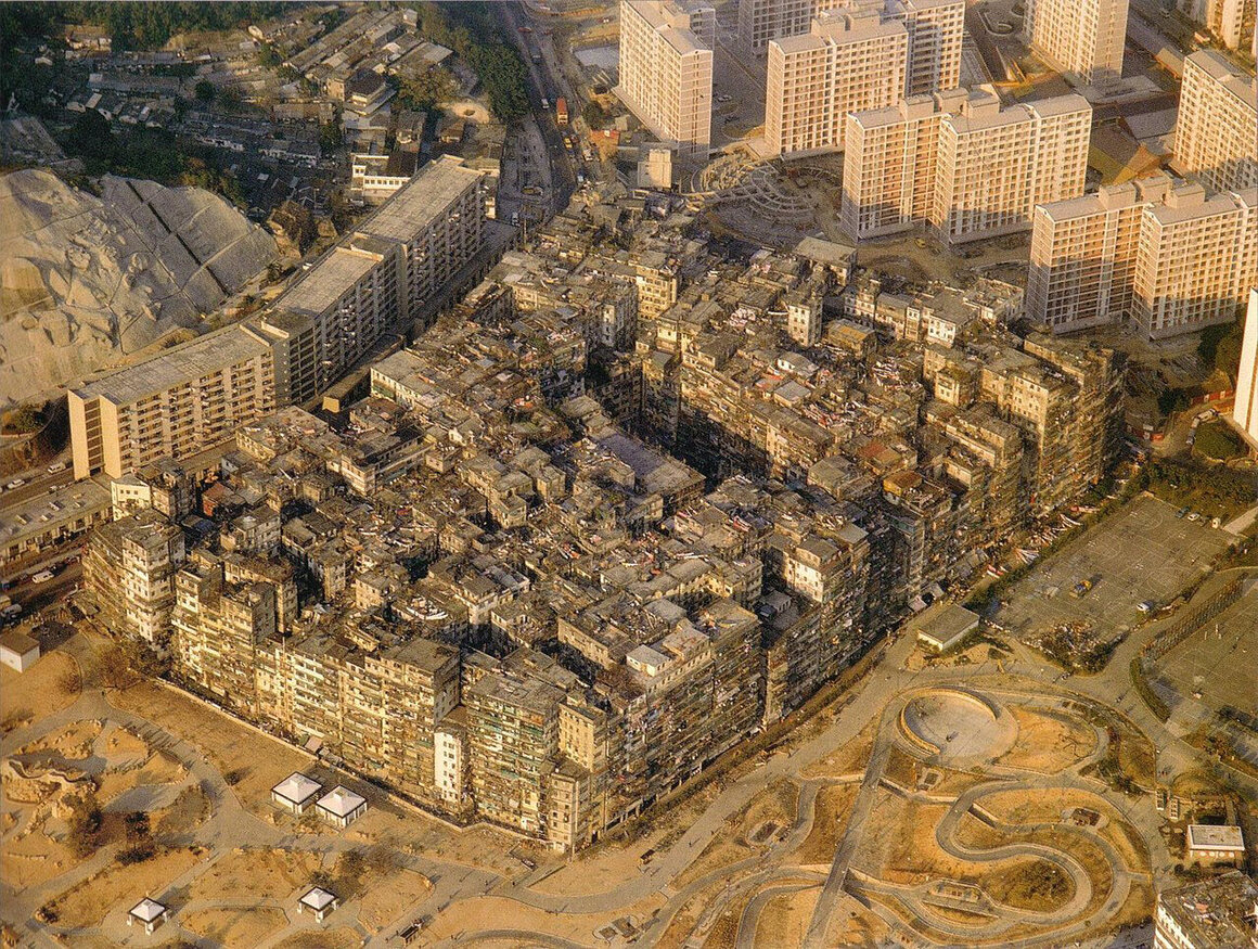
The most densely populated city on Earth had only one postman. His round was confined to an area barely a hundredth of a square mile in size. Yet within that space was a staggering number of addresses: 350 buildings, almost all between 10 and 14 stories high, occupied by 8,500 premises, 10,700 households, and more than 33,000 residents.
The city’s many tall, narrow tower blocks were packed tight against each other—so tight as to make the whole place seem like one massive structure: part architecture, part organism. There was little uniformity of shape, height, or building material. Cast-iron balconies lurched against brick annexes and concrete walls. Wiring and cables covered every surface: running vertically from ground level up to forests of rooftop television aerials, or stretching horizontally like innumerable rolls of dark twine that seemed almost to bind the buildings together. Entering the city meant leaving daylight behind. There were hundreds of alleyways, most just a few feet wide. Some routes cut below buildings, while other tunnels were formed by the accumulation of refuse tossed out of windows and onto wire netting strung between tower blocks. Thousands of metal and plastic water pipes ran along walls and ceilings, most of them leaking and corroded. As protection against the relentless drips that fell in the alleyways, a hat was standard issue for the city’s postman. Many residents chose to use umbrellas.
There were only two elevators in the entire city. At the foot of some of the high-rises, communal and individual mailboxes were nailed to the walls. But often the only option for the postman was to climb. Even several stories up, the maze of pathways continued: knotted arteries that burrowed into the heart of the city along interconnecting bridges and stairwells.
Sometimes the postman would reach a top floor and climb out onto the roof. Gangways and rusting metal ladders let him move quickly from building to building, before he dropped back down into the darkness. While some alleys were empty and quiet, others overflowed with life. Hundreds of factories produced everything from fish balls to golf balls. Entire corridors were coated with the fine flour dust used for making noodles. Acrid, chemical smells filled the streets that lay alongside metal and plastic manufacturers. Unlicensed doctors and dentists clustered together, electric signs hanging over their premises to advertise their services. Many patients came from outside the city, happy to pay bargain fees in return for asking no questions. Shops and food stalls were strung along “Big Well” Street, “Bright” Street and “Dragon City” Road. For the adventurous, dog and snake meat were specialties of the city.
Moving deeper, long corridors offered glimpses into smoke-filled rooms. The incessant click of mahjong tiles echoed along the walls. Gambling parlors lined up alongside strip clubs and pornographic cinemas. Prostitutes—including children—solicited in the darkness, leading clients away to backroom brothels. And everywhere there were bodies lying in the gloom. At Kwong Ming Street—known as “Electric Station”—wooden stalls sold cheap drugs. Addicts crouched down to inhale heroin smoke through tubes held over heated tinfoil. Bare rooms, enticingly referred to as “divans” were filled with prone men and women, all sunk in opium stupors. Many of the city’s rats were addicts too, and could be seen writhing in torment in dark corners, desperate for a hit.
There was no law to speak of. This was an anarchist society, self-regulating and self-determining. It was a colony within a colony, a city within a city, a tiny block of territory at once contested and neglected. It was known as Kowloon Walled City. But locals called it something else. Hak Nam—the City of Darkness.
In the aftermath of the first Opium War of 1839 to 1842—sparked, in essence, by the Chinese government’s attempts to prevent the East India Company from importing narcotics—China signed a treaty ceding a portion of its territory to Great Britain: a near-deserted, mountainous island with a sheltered, deep-water harbor at the entrance to the Canton River, opposite the Kowloon Peninsula. Hong Kong.
In 1843, the Chinese began to build a fort at the very tip of the Kowloon Peninsula, with an office for the Mandarin (the government official) and a barracks for 150 soldiers, surrounded by a wall that was 700 feet long and 400 feet wide. Known as Kowloon Walled City, it was intended as a visible Chinese military presence near the new British colony. In 1860, disputes over trade sparked a second Opium War. British and French forces devastated the Chinese, and a new treaty granted the whole of the Kowloon Peninsula to Britain, with a solitary exception—the Walled City.
Over the next 30 years, British authorities attempted to negotiate control of the city, but the Chinese remained firm. Even a new treaty in 1898, which granted Hong Kong, Kowloon, and further territories in Canton to Britain for 99 years, kept the Walled City under Chinese control. A year later, in May 1899, rumors circulated that Chinese soldiers were massing again in the Walled City, so the British sent troops across the water. They expected battle—perhaps another war—but found only the Mandarin. The irate official left too, and the British took the city, though the Chinese never renounced their claim. Missionaries moved in and built churches and schools, pig farmers from the surrounding hills took plots of land within the walls. There was almost no administrative control, and the city became a slum. Yet whenever the Hong Kong government tried to clear it to turn it into a park—evicting the residents in the process—the Chinese government always stepped in. After all, this tiny rectangle of land was still officially their territory.
The situation remained unresolved until the outbreak of World War II. Japanese forces occupied the Kowloon Peninsula and tore down the walls of the city to build a new runway for nearby Kai Tak Airport.
In the aftermath of the war, refugees flooded south to the Kowloon Peninsula. The only trace of the old city was the derelict shell of the Mandarin’s house. Yet people gravitated almost instinctively to this rough rectangle of ground. Perhaps it was the feng shui. The Walled City had originally been laid out according to the ancient principles of Chinese philosophy: facing south and overlooking water, with hills and mountains to the north. This ideal alignment, it was said, brought harmony to all citizens. In their desperate plight some refugees may have believed that Kowloon would be a much-needed source of luck and prosperity. Others, however, recalled that this had once been a Chinese enclave in British colonial territory. The stone walls of the “Walled City” had gone, but the refugees were convinced the diplomatic ones remained.
By 1947 there were more than 2,000 squatters camped in Kowloon, their ramshackle huts arranged in almost the exact footprint of the original city. No one wanted to find themselves outside the borders—those on the wrong side of the line risked losing the protection of the Chinese government. The people kept coming, and the camp grew ever more squalid and overcrowded.
Appalled by the conditions, the Hong Kong authorities made plans to clear the refugees. On January 5, 1948, the Public Works Department, supported by a large police presence, removed the squatters and demolished all the slum housing. Within a week, however, the occupiers had returned to rebuild their shacks. When the police attempted to intervene, a riot broke out. News of the disturbances spread across China, and the plight of the “residents” of Kowloon became a cause célèbre. The British consulate in Canton was set on fire, and a group of students in Shanghai staged a protest strike. Officials from the Chinese government traveled to the Walled City—and officially encouraged the refugees to continue the struggle against their British oppressors.
The provincial Canton government sent a delegation on a “comfort mission” to the region, supplementing the distribution of food and medical aid with messages advocating militant action. The Chinese Foreign Ministry continued to argue that they retained jurisdiction over the city and its people. Amid mounting tension, the Hong Kong government relented. The eviction program was halted, and the police withdrew. From a temporary refugee camp, Kowloon now began to evolve into something more permanent. A new city was being founded on the ruins of the old.
What kind of city? Naturally, the judgment of Sir Alexander Grantham, Governor of Hong Kong from 1947 to 1957, was damning. Kowloon, he wrote, had become “a cesspool of iniquity, with heroin divans, brothels and everything unsavoury.” The Chinese claims to sovereignty over Kowloon did not extend to any day-to-day administration; they merely used its uncertain status as a convenient tool for political point-scoring. After the disturbances in 1948, the Hong Kong government had settled on a similar policy of non-intervention. The result was a city outside the law: There was no tax, no regulation of businesses, no health or planning systems, no police presence. People could come to Kowloon, and, in official terms, disappear. It was little surprise that criminal activity flourished. Five Triad gangs—the King Yee, Sun Yee On, 14K, Wo Shing Wo, and Tai Ho Choi—took up residence. Kowloon’s extralegal status made it the perfect place for the manufacture, sale and use of drugs such as opium and heroin. The city that had been founded to police the traffic of opium became the epicenter of Hong Kong’s narcotics trade.
Organized crime may have dominated much of Kowloon, but it did not define the city. Entrepreneurs, attracted by low rents offered by private landlords, saw a unique opportunity. Hundreds of factories were established, with entire families manning the production lines. Conditions were often appalling, yet productivity—and profit—remarkable. Goods made in Kowloon were exported throughout Hong Kong, China, and even, in some cases, the world. Plastics and textile manufacturing were a specialty, as was food production. To the blissful ignorance of Hong Kong’s well-heeled residents, the dumplings and fish balls served in their restaurants were frequently sourced from Kowloon.
The citizens of the Walled City demonstrated an extraordinary capacity for change and adaptation. The boundaries of their world were tightly constrained, yet, as more people continued to enter the city, their architecture met the demand. As modern high-rises grew up in Hong Kong, the builders of Kowloon copied what they saw, erecting tower blocks of their own. Thin columns, established on foundations often consisting of thin layers of concrete poured into shallow trenches, started to extend skywards. With no requirement for planning permission, structures were thrown up with amazing speed. Subsidence and settlement were common. Because the high-rises would often lean against each other, residents called them “lovers’ buildings.”
As the blocks began to merge together, the city became less a collection of buildings and more a single structure, a solid block filled with thousands of individual units designed to meet every requirement of a city: living, working, learning, production, commerce, trade, and leisure. Increasingly, residents were physically sealed off from the outside world. Light did not penetrate down to the narrow lanes leading between the high-rises. It was the beginning of the City of Darkness.
A system of self-government gradually emerged. In 1963, for the first time in over a decade, the Hong Kong authorities attempted to intervene in Kowloon, issuing a demolition order for one corner of the city, and proposing to relocate the displaced residents to a new estate development nearby. When the plans were made public, the community instantly formed a “Kowloon City anti-demolition committee.”
At 9:20 am on January 14, 1987, 400 officials from the Hong Kong Housing Department erected cordons around the 83 streets and alleys leading into and out of the Walled City. Then they entered the city on a mission to contact and survey every single resident. Earlier that morning, it had been announced that the city was to be cleared and redeveloped as a public park—just as the Hong Kong Government had intended over half a century before. Except this time, there was to be no Chinese resistance. Two years earlier, on December 19, 1984, the governments of China and Great Britain had signed a joint declaration to transfer sovereignty of Hong Kong back to China on July 1, 1997. The Chinese Foreign Ministry had always used Kowloon as a political pawn to remind the British and the world of their claim over the land granted to Britain in 1898. The 99 years were almost up.
The plans for clearance and demolition were kept secret. Compensation was a key element of the eviction process, so there was the danger of a sudden influx of people looking to take a slice of government money. For six months, the Housing Department kept Kowloon under surveillance to gather evidence of population numbers. The compensation package for residents and business owners totaled $2.76 billion. On average, residents received around $380,000 for their individual flats. Negotiations progressed over several years, and by November 1991, only 457 households were still to agree terms. By that time, most of the 33,000 residents had moved out. Some, however, clung on to the end, and on July 2, 1992, riot police entered the city and forced out the last remaining residents. A tall wire fence was erected to encircle the whole site—following almost exactly the line once marked out by the city’s original granite wall.
On March 23, 1993, a wrecker’s ball smashed into the side of an eight-story tower block on the edge of the Walled City. This was a solitary, ceremonial swing. The real work of demolishing Kowloon, piece by piece, would begin several weeks later. The moment was applauded by a crowd of invited guests and dignitaries. It was also greeted with shouts of anger from former residents who had gathered for one last, futile protest. It took almost exactly a year to reduce the rest of the city to dust and rubble.
Remarkably, from within the modern wreckage, fragments of the original city emerged. There were two granite plaques, each marked with Chinese characters: One read “South Gate,” and the other “Kowloon Walled City.” Once the ruins of the tower blocks had been cleared away, developers uncovered segments of the foundations of the original wall, along with three of the iron cannons that had once bristled from the city’s ramparts. A solitary building still stood at the center of Kowloon, the one structure to have survived throughout its whole turbulent history—the office of the Mandarin. Over the course of the next year, the ruins began their rapid conversion into a landscaped park, modeled on the famous 17th-century Jiangnan gardens built by the Qing Dynasty.
The paths running through these new gardens were named after the streets and buildings of the demolished slum. The Kowloon Walled City Park was officially opened on December 22, 1995, by the British Governor of Hong Kong, Chris Patten. It had taken some six decades, but at last Kowloon was transformed into the “place of popular resort” envisaged by Sir William Peel, the Governor of Hong Kong in 1934: six-and-a half acres of ornate bamboo pavilions, pretty water features, and vibrant greenery.
This is the story of the rise and fall of a slum. It was born out of a quirk of history, it exploited its unsavory reputation, and, as is the fate of all slums, it became an embarrassment before being leveled by the authorities. Is there any greater significance to its story than that? Many would argue not. But while locals and tourists now enjoy the park, some still crave the claustrophobic darkness. Theorists from the wilder shores of architecture keep returning to the idea of Kowloon. On this tiny rectangle of ground, a single community created something that had only existed before in the avant garde imagination: the “organic megastructure.”
The concept of the megastructure emerged in the late 1960s, as a radical departure from the conventional idea of the city. Instead of buildings being arranged around public spaces, streets, and squares, the megastructuralists envisioned one continuous city binding citizens together in a set of modular units, capable of unlimited expansion. It was a city designed to live, evolve, and adapt, fulfilling all the needs of its people, and with the capacity to endlessly “plug in” more units to meet changing desires.
Architects pushed this idea to extremes, most sensationally in the work of Alan Boutwell and Michael Mitchell, who in 1969 proposed a “continuous city for 1,000,000 human beings.” They envisaged a single, linear city, sitting on 100-meter-high pillars, running in a straight line between the Atlantic and Pacific coasts of North America. Kowloon, in effect, was proof of concept. Within its anarchist society, argued the megastructuralists, was the kernel of an architectural utopia.
Others, however, saw Kowloon not as a petri dish for urban theory, but as a model or diorama for a new kind of construction—one that did not exist in the ordinary physical plane, yet was as real as anything that could be seen or touched. The renowned American science fiction writer, William Gibson, described Kowloon, not long before its demolition, as a “hive of dream.” What Gibson saw in the unregulated, organic chaos of the City of Darkness was an embodiment of his famous concept of “cyberspace”—or, as we would call it today, the internet.
In its formative years, the internet provided the perfect environment for the establishment of multiple, self-regulating communities. Just like the Walled City, it operated outside of law or external oversight. It was post-design and post-government. Thousands, even millions of Kowloons could spring up at will in cyberspace: digital enclaves thriving on creative and political freedom, possessing an autonomous, dynamic structure that allowed them to grow at a frightening, near-exponential rate. It was also, just like the Walled City, living on borrowed time. “I’d always maintained that much of the anarchy and craziness of the early internet had a lot to do with the fact that governments just hadn’t realized it was there,” commented Gibson. “It was like this territory came into being, and there were no railroads, there were no lawmen, and people were doing whatever they wanted, but I always took it for granted that the railroads would come and there would be law west of Dodge.”
Yet to Gibson’s mind, the people of Kowloon—and the megastructuralists—were groping toward the next stage in human evolution. He saw the Walled City, that accident of urban birth, as a crude, subconscious schematic of the future, a blueprint for coders and hackers, the architects of the web, to follow. In his 1996 novel Idoru, Gibson imagined a virtual Kowloon, a Walled City 2.0 recreated as an ultra-libertarian web sanctuary: “These people, the ones they say made a hole in the net, they found the data, the history of it. Maps, pictures ... They built it again.”
So the wrecking ball may not only have been destroying a notorious slum. Perhaps Kowloon was also the first, true, physical monument to the internet. A city that offered a glimpse into the infinite horizons, structural possibilities—and inherent amorality—of the digital realm.
The spring pygmy sunfish and a Mazda Toyota plant are going to be neighbors.
The spring pygmy sunfish has already been declared extinct two times, and now its champions hope to ensure there won’t be a third. In 1938, one year after the tiny blue fish was first discovered in a spring in Lauderdale County, Alabama, the spring flooded, the sunfish died, and the species was thought to be extinct. In 1941, the fish was rediscovered in a different spring in Limestone County, Alabama. But that population, too, met a similar end, and the sunfish was once again considered extinct. In 1973, the fish popped up once again in the Beaverdam Spring complex near Huntsville, Alabama, where it survives today. “The fact that it’s held on for this long almost compels you to protect it,” says Elise Bennett, a staff attorney at the Center for Biological Diversity.
The unsinkable spring pygmy sunfish is getting a new neighbor soon: a Mazda Toyota manufacturing plant that can churn out 300,000 automobiles each year. A development that size, and the chemicals and soil disturbances that come along with it, could pose a serious threat to the diminutive fish, which has only two populations known to science, Bennett says. In 2018, the center, Mazda Toyota Manufacturing, U.S.A., and the nonprofit Tennessee Riverkeeper reached an agreement protecting the Beaverdam sunfish from a future extinction crisis, conserving 1,100 acres of land and creating a $6 million endowment for the fish’s welfare. The agreement was finalized last month, according to AL.com.
As its name suggests, the spring pygmy sunfish is incredibly small, rarely growing more than an inch. Females are a mottled brown; males are dark with iridescent blue bars across their bodies, and they turn sapphire blue when breeding. It’s picky about where it lives, requiring fresh, clean water near the springhead, Bennett says. The fish take refuge in filamentous, feathery plants, including spineless hornwort and two-leaf water milfoil, which protect both adult and juvenile fish from predators, according to a report from the U.S. Fish and Wildlife Service. Though Alabaman conservationists tend to know about the spring pygmy sunfish, it’s far from a household name. “People will ask, ‘What’s a sunfish, and can we fry it up?’” Bennett says. (Please don't.)
After the spring pygmy sunfish was originally discovered, at Cave Spring in Lauderdale County, scientists located two other populations, at Pryor Spring and Beaverdam Spring. But over the past century, according to Bennett, these habitats have disappeared or declined due to a whole host of factors: pesticide and herbicide runoff from nearby farms, dam-induced flooding, sediment overflows from nearby developments. In 1984, scientists attempted to reintroduce the sunfish to a section of Pryor Spring, according to a report by the Center for Biological Diversity. The fish survived there for 20 years, but died off in 2008 due to nearby groundwater harvest and an influx of herbicides. (A few years ago, one more surviving population of the spring pygmy sunfish was discovered in Blackwell Swamp, in Wheeler National Wildlife Refuge.)
In 2009, the Center for Biological Diversity petitioned the government to protect the fish under the Endangered Species Act, without success. So they partnered with Mike Sandel, a fisheries scientist at the University of West Alabama, who helped secure the fish’s protection in 2013. But the incoming auto plant, in an increasingly developed Huntsville, seemed to pose a new threat. So the center turned to one of conservationists’ classic “tools in the bag,” Bennett says: buying land and putting it into a trust.
After months of negotiations with the center and Tennessee Riverkeeper, Mazda Toyota Manufacturing, U.S.A. agreed to set aside $4 million for the future conservation of the fish. Nearly 500 of the contracted 1,100 acres have already been purchased by the land trust, Bennett says. No high-impact development, such as lumber extraction, pesticides, or groundwater removal will be allowed in this tract of land, according to the agreement. These new protections will also benefit the other species living in Beaverdam Creek, such as the endangered slender campeloma snail, another Alabama native. “The hope is that, in the future, this land could be a publicly accessible area with trails,” she says. “Or even an educational center.”
Once, while visiting the Beaverdam site, Bennett spoke with a local high school teacher who had studied the spring pygmy sunfish in college, back when the population was so plentiful that you could catch one right under an overpass by a highway. “She said she thought about those fish all the time, that she’d bike by a few times a week and stop by the spring,” Bennett says. She often thinks of the tiny, resilient fish when she has a bad day. “You remember the sunfish has been hanging in there, and you know you can, too.”
Inside a bright Brooklyn gallery that is plastered in photographs of apples, William Mullan is being besieged with questions.
A writer is researching apples for his novel set in post-World War II New York. An employee of a fruit-delivery company, who covetously eyes the round table on which Mullan has artfully arranged apples, asks where to buy his artwork.
But these aren't your Granny Smith's apples. A handful of Knobbed Russets slumping on the table resemble rotting masses. Despite their brown, wrinkly folds, they're ripe, with clean white interiors. Another, the small Roberts Crab, when sliced by Mullan through the middle to show its vermillion flesh, looks less like an apple than a Bing cherry. The entire lineup consists of apples assembled by Mullan, who, by publishing his fruit photographs in a book and on Instagram, is putting the glorious diversity of apples in the limelight.
Mullan, whose day job is as a brand manager for Raaka Chocolate, can rhapsodize about apples at length. He notes that the api etoile, an apple of Swiss or French origin that grows into a rounded star shape, is hard to find, with the trees he's seen bearing fruit little and lately. He likens them to Pokémon. "You're really lucky if you catch it," he says with a laugh.
But he quickly sobers. "It's a shame because they're really cute, they're really delicious." Due to the demands of industrial farming, only a handful of apple varieties make it to stores, and even of those, only the most uniform specimens sit on the shelves. Growers have abandoned many delicious or beautiful varieties that have delicate skin, lower-yield trees, or greater susceptibility to disease.
Mullan was born in the United States, but grew up in the United Kingdom, where a teenage encounter with an Egremont Russet led to his love of apples. Its spicy, persimmon-like flavor "just blew my mind," he says. But many of the apples he's photographed were born in North America, including such romantic cultivars as the Black Oxford and Hidden Rose.
When health issues forced Mullan to change his diet, he satisfied his sweet tooth on apples, using the internet to research different varieties. After moving to Southern California, Mullan entered a period of what he dryly calls "apple famine." Only when a nearby store started carrying Pink Pearl apples from Oregon was Mullan's obsession rekindled. In his gallery, Mullan, who is wearing pearl earrings, gestures to a photograph of the Pink Pearl, which, with its translucent white skin and shell-pink interior, is almost painfully beautiful. The Pink Pearl, he explains, was bred in the 1940s by Californian Albert Etter from a red-fleshed British apple called "Surprise."
After moving to New York and wielding a camera professionally, Mullan started seeking out and photographing apples from local markets, highlighting their unique colors and shapes. Apples are a popular crop in the Northeast, but there are more than 7,000 known varieties of apples in the world, which is an astonishing amount of diversity.
Mullan's search for rare apples has even led him to photograph varieties with no name. After an article about Mullan's book was published in the New York Times last year, he was invited to Geneva, New York, to visit the USDA's apple-research orchard. There, he picked up some craggy Malus Sieversii PI 596280 apples from Uzbekistan. Another tiny green specimen Mullan shows me is christened "Bean," after the astronaut Alan Bean, who took its seeds around the moon. Mullan has a soft spot for Bean, especially since the USDA website describes it as small, [acidic], and "worthless."
With such a unique subject, it's perhaps no surprise that the 200 copies of Mullan's Odd Apples, a book produced with designer Andrea A. Trabucco-Campos, has sold out. While he's still selling prints, another book is in the works. "There's just this sense of infinity with [apples] thatI love," Mullan says. While he imagines he'll move on to other subjects in the future, for now, he's still entranced by apples.
Soon, he's slicing into a Knobbed Russet apple, offering me a creamy, tannic slice. It's a little soft, but after weeks on display, that's to be expected. Without any Photoshop, a photo of a Knobbed Russet gleams gold on the wall, preserved for much longer.
More Americans are turning to these shaggy-haired animals for their meat, milk, and hides.
“You boys want to buy a yak?”
Lynette Priest, a yak owner from Mancelona, Michigan, is sizing up potential customers in the parking lot of a farm in Tully, New York.
Standing in front of a large wooden barn nearby, Jane and Jon Marbet look lost. The Plymouth, Massachusetts couple recently started thinking about putting a small farm on their empty plot of land in Maine. Today they drove here to Tully, a town of green rolling hills, to look for an animal or two to put on that farm. Something endearing and large and, better yet, tasty—preferably with a low fat content.
“First we wanted buffalo,” Jane says, “until we went to a buffalo farm—”
“—and they just want to kill you,” finishes her husband.
The couple’s dreams of fresh lean meat to stock and sell were put on hold. But then they heard about yaks.
Today they join local farmers, interstate yak sellers, and other yak-curious people for a special annual trade event: Yakapalooza.
A couple million years ago, in the wide strip of land running from the Himalayas of South Asia to the Tibetan Plateau, modern-day wild yaks (Bos mutus) first appeared. They were significantly smaller and hairier than their ancestors, the aurochs, who are also common ancestors to European and North American cattle. The domestic yak (Bos grunniens), bred by occupants of South Asia between 7,000 and 10,000 years ago, has large lungs and thick, long fur necessary for survival in high altitudes and frigid temperatures. Today the animals speckle slopes and divots of mountains across Central and East Asia, impassive dark spots against snowy peaks.
Yaks form a key part of modern rural life in these regions, used to lug supplies and people up to extreme heights. In Tibet, Nepal, and India, all parts of the animal are used—fur for clothes, milk for cheese and drink, meat for food, horns for combs, tail for broom brushes, skin for cloth, and dung for fuel.
In the United States, yak is mainly advertised as an alternative to beef, but better in every way: more environmentally sustainable, tastier, healthier. Jon and Jane Marbet first stumbled across the meat for sale online a couple of years back and were instantly hooked. The animals also, according to the couple, do not want to kill you. Which is why they are here now, standing in front of a large wooden barn in Tully, New York, ready to buy some yaks.
The barn in question is on a farm called Bentwood Alpacas and Yaks, owned by Suzanne and Mark Drumm. Inside are 20 alpacas that chase each other around on stubby legs, tilting their long necks at precarious angles, screaming. Outside the barn, standing with heads bowed on gentle slopes of grass, are the yaks. Some are a solid dark brown or black, others are patched with white. The Drumms own around 40 yaks, but today there are an additional dozen or so on their land.
The yaks present at Yakapalooza outnumber humans three-to-one. Inside another large barn are two tents set up by attending yak owners, most of whom are members of IYAK, the International Yak Association. Despite its name, IYAK consists only of farmers living in the United States. As yak popularity in the U.S. skyrocketed in recent years, mainly due to the animal’s lean cuts of meat, the organization, and the zeal of its members, has grown significantly.
The President of IYAK, Stephanie David, owns Bow Creek Ranch in Kansas with her husband, Doug. Doug David stands beneath his tent with five plates of yak jerky laid out in front of him. People periodically filter by, slapping him on the shoulder and spearing samples with wooden toothpicks. The packets of meat are around $12—pricey for a bag of jerky—but people keep swinging by, grabbing bags of the stuff in one hand while holding out folded bills in the other.
Doug grew up in Western Kansas on a cattle farm, and in the late 1990s was one of the first people to venture into the world of North American yak farming. Back then, Doug estimates, there were only 600 yaks in the entire continent. Now there are more than 20,000. He remembers trying the meat for the first time at the Denver Stock Show and being impressed enough to buy a couple of animals on the spot. “I just wanted to try something different,” he says, shrugging.
Now, Doug and Stephanie own one of the largest yak herds in North America—more than two hundred animals. “I can hardly keep enough,” Doug says. “The meat market has exploded.”
But the market is still tiny compared to that of other standard farm animals. There are nearly 100 million cattle in the U.S., and a cut of grass-fed beef is usually about half as expensive as a similar cut of yak meat. This is mainly because the USDA still considers yaks “exotic” animals, requiring inspection of the meat from “hoof to packaging,” each hour costing the farm owner upwards of $85. IYAK is working to get the animals delisted, but has had no success yet.
The environment in Western Kansas, and most parts of the U.S., is also significantly warmer and wetter than that of Tibet and Nepal. Maintaining a herd in these conditions is expensive. Doug has to move most of his animals all the way to Colorado when the weather starts getting too hot on his ranch in Lenora, Kansas.
For many, yak farming has become more of a hobby than a money-making scheme. Ron Ireland, who owns a farm with his wife in northern New Jersey, is a fairly serious yak owner but still ends up in the red every year. “We’ve been at it 15 years and haven’t made any money,” he tells me, though this fact doesn’t seem to upset him too much—he says so while winking and smiling.
Yakapalooza is thrown by IYAK for yak farmers all over the country. In attendance are local farmers, including Szabolcs Mandy, a Hungarian immigrant who lives in Tully and works as a pediatric anesthesiologist on the weekdays, and farmers who drove for days to be here: Holly Modjeski, the treasurer of IYAK, is on the last stop of a 3,500-mile yak transportation trip from Colorado to Montana to Kansas to New York. The event offers an opportunity for these farmers to get together, bond over their yaks, and maybe even get some business. Most of the people here are already close acquaintances, and fresh faces, though few in number, are sized up as potential customers.
But a yak is a serious investment. The animal itself can cost anywhere between $1,000 and $10,000, without taking into account equipment and upkeep. By the end of the day—after a yak photo competition and a yak chute demonstration and a yak fiber judging—as the sun sinks below the trees of Bentwood Farms, very few yaks have been sold. The number could be counted on one hand.
But this doesn’t seem to bother the 20 or so people inside the Drumm’s large barn. Each person appears content with this little gathering, particularly Jane and Jon Marbet, who are proud new owners of three yaks.
You can join the conversation about this and other stories in the Atlas Obscura Community Forums.
From royal abode to performance-art venue, Malcha Mahal has a rich and mysterious history.
On a pleasant October day, four men undressed and exposed their naked bodies to the Indian parliament. No government official could have seen it. The men were standing several miles away, atop a centuries-old monument deep inside New Delhi’s Central Ridge Forest. The site is invisible from the heart of India’s government—and largely forgotten by it as well.
The symbolic act was the culmination of a performance-art workshop held inside the red sandstone structure, known as Malcha Mahal. It was organized by Ajay Sharma, an upcoming artist and college instructor, and attended by Inder Salim, a veteran Indian performance artist.
Originally from a small town in eastern India, Sharma says he doesn’t much like the metropolitan city of Delhi. But he does like abandoned monuments: They’re perfect places to find peace and inspiration. (Before this arts workshop in Malcha Mahal, he held similar ones in the Begumpur Mosque, in south Delhi’s Malviya Nagar neighborhood.)
When Sharma initially visited this site, months earlier, he didn’t know much about the building’s past. But he “was totally captured by the energy of the space,” and says that he could intuitively tell that it was the right venue for his workshop.
His intuition was strong: Perhaps more than any other monument in Delhi, Malcha Mahal embodies the country’s long, complicated history, from medieval times through colonial rule and Independence to the politics of present-day India. Which makes it an apt venue for artists who want to express themselves politically.
Artists like Salim. One of the four naked men on the roof, Salim says that when he “saw the parliament from that distance, I decided to undress and kick some dust at it”—a way to express his feelings about a matter close to his heart.
Salim is originally from the restive region of Kashmir, but fled to Delhi in the 1990s, after violence broke out. He recently filed a petition against the government after its controversial decision to withdraw the region’s partial autonomy. The move was squarely on his mind during the act—and Malcha Mahal brought it to the fore. “The monument itself,” he says, “motivated me to do this.”
Standing on the building’s flat roof is like standing in an open field just above the forest, overlooking a sprawling city veiled in a smoggy haze. In the middle of Delhi—one of the most populated cities in the world—it feels completely isolated.
To reach Malcha Mahal, you have to enter the Central Ridge Forest, a surprisingly dense stretch of greenery at the edge of an affluent diplomatic enclave called Chanakyapuriin, in the heart of India’s capital. The same forest houses the remaining boundary walls of an ancient water reservoir and an 800-year-old dargah, or shrine on the tomb of a Sufi saint, which is surrounded by dozens of earthen pots said to imprison the spirits of bad souls and djinns. The caretaker of the dargah still holds regular exorcisms to add to the collection.
At the end of a short, bumpy ride on an unkempt pathway full of garbage, monkeys, and the occasional jackal, a narrow footpath—lined by broken barbed wire and rows of long thorny plants—leads to an imposing building with arched gateways and high ceilings.
No one currently administers Malcha Mahal, and the governmental Archeological Survey of India has shown no interest in managing it. A nonprofit called the Indian National Trust for Art and Cultural Heritage (INTACH) filed a proposal in October to conserve it on behalf of the Delhi government.
For now the walls are occupied by bees, and the ceilings by bats. Trees are growing through the windows and staircases that lead to the roof. Centuries after it was built, the monument has become almost one with its surroundings.
Most historians say that Malcha Mahal was built as a royal hunting lodge during the rule of Feroz Shah Tughlaq, the sultan of Delhi from 1351 to 1388. “Malcha Mahal” means “Deer Palace,” and Malcha was the name of a pastoral village that used to surround the monument.
In the 19th century, the hunting lodge came into the possession of the rulers of Oudh, an independent kingdom located in today’s Uttar Pradesh—India’s largest state. The kingdom was annexed by the British in 1856, and its last king, Wajid Ali Shah, was exiled to the city now called Kolkata.
Shah, a Muslim, was accused by the British of being a debauched and dissolute ruler. But he was popular among the majority Hindu population he ruled over, due to his love of Hindu myths, arts, and deities. That made him a threat to the British colonizers, who believed in keeping their Indian subjects divided along religious lines. The annexation of Oudh had sown discontent among the native soldiers, and is considered an important factor leading to the Sepoy Mutiny of 1857, also called India’s first war of independence.
The Malcha villagers fought in the mutiny. Not long after, they were displaced when the British decided to move their capital to New Delhi, in 1911, and develop the Central Ridge for horse riding. At least 30 people are said to have been killed by the British for resisting colonial rule. To this date, the villagers’ descendants are still fighting for monetary compensation for their lost land.
A little over a century after Oudh’s annexation, a woman who claimed to be the last rightful heir of Shah arrived in Delhi. Calling herself the Royal Highness Wilayat Mahal, she was accompanied by her two children, an entourage of servants, and a dozen ferocious dogs. She demanded that the Indian government restore at least some of the properties that were seized over a hundred years earlier.
The family and its entourage squatted in a waiting room in the New Delhi railway station for more than a decade, causing a sensation and drawing the notice of the international press. The Indian government ultimately caved, and in 1984, Wilayat and her children, by then young adults, were offered one of the Oudh king’s previous possessions to live in: Malcha Mahal.
At that point it had already been discovered by artists. Just a decade earlier, the monument—then known as Bistedari Malcha, in reference to the columns used in the structure—had been an artists’ studio managed by the national arts academy Lalit Kala Akademi.
“It was beautiful, surrounded only by nature,” recalls painter Shanti Dave, now 89. At the time he was an internationally established artist known for his large murals, including one that he painted in 1964 at JFK Airport in New York. Photos of him standing in front of Malcha Mahal in the late 1960s show a monument not yet overgrown with brush and vegetation. There was space to stand back and take a picture of the entire structure—something that’s impossible today.
“We were young artists, trying to find out who we were after Independence,” says Dave, now partially blind and hard of hearing. His fond memories of the space include a ceiling-high painting he made there, a jackal that once occupied his studio for days, wood-fired lunches, and moonlit performances on the roof by the famous Indian classical dancer Uma Sharma.
The artists, who had moved into Malcha Mahal in 1967, had to vacate the premises 10 years later, when the Delhi Earth Station—a structure used for satellite observations by the national space agency, the Indian Space Research Organization (ISRO)—was officially inaugurated. The artists didn’t leave Malcha Mahal in shape for permanent inhabitants, though they had installed metal shutters on all the outer gates, to keep the monkeys out and protect their artwork.
Nowadays all of those shutters are broken or hanging in the nearby trees. But for years they proved useful to Wilayat and her children, who lived there, under spartan conditions, for decades.
“We had to make do without any water or electricity,” says Mohammed Kasim, one of the servants who lived at Malcha Mahal with the family. “We even dug up a well, but it remained dry. Water was scarce in the area.” Yet over the next few years, the family—with the help of guards working at the Earth Station—managed to get some water, as well as on-and-off-again electricity.
The family’s residence in Malcha Mahal ended in 2017, when Wilayat’s son—the man calling himself Prince Ali Raza aka Cyrus of Oudh—died. (His sister, known as Princess Sakina, passed sometime in 2015. Their mother had taken her own life years earlier, in the 1990s.
A recent article in The New York Times concluded that they were a family of highly convincing impostors who, for decades, fooled journalists, government officials, and much of the public. According to the Times, the prince and princesses’ names were, respectively, Farhad and Mickey Butt.
Kasim takes issue with this conclusion, agitatedly calling it “false and very wrong.” Walking through the ruins of Malcha Mahal, he points to some of the family’s remnants, which lay scattered about: an old, upmarket fridge; a metal trunk with “Oudh” written on it; a wooden table; torn clothing; and several single shoes—all covered in bat feces.
Kasim gets emotional when he sees the condition of his former masters’ attire. “This belonged to the prince,” he says, respectfully picking up a torn and dusty golden-colored formal jacket.
Whether they were actually royal or not, the fascinating family that lived here has given rise to a spate of ghost stories. A growing number of thrill-seekers have been visiting Malcha Mahal in recent months, filming their overnight stays in search of spectral encounters—among other local legends, the ghost of Ali Raza is said to slap intruders—and posting them online.
In one video full of special effects and spooky sounds, produced by the channel News24, two journalists discover an old fridge covered in red powder and speculate about its origins, wondering whether they’ve found the site of a Tantric ritual.
What they had actually found were the remnants of a performance-art video that Sharma had produced there, several months before he organized the workshop.
In the video, shown at a recent festival of performance art in South Korea, Sharma is seen fully naked, sitting on some of the furniture in Malcha Mahal, his face covered with a huge piece of meat. Later, as he stands in the gated archways inside the monument, his face is covered by a cow’s skull.
The work is an artistic commentary on the growing intolerance toward Muslims in today’s India—currently governed by the Hindu-nationalist Bharatiya Janata Party—and directly inspired by a brutal, heavily publicized mob-lynching incident four years ago. In 2015, a Muslim ironsmith named Mohammad Akhlaq was killed by dozens of his Hindu neighbors on suspicion of having eaten beef. The meat of a cow—holy to Hindus—was allegedly stored in Akhlaq’s fridge.
With its “layers of history," says Sharma, Malcha Mahal was a perfect venue for the video. The fact that the site already held an abandoned fridge only made it more conducive to his needs.
“I needed a fridge for this performance,” says Sharma. “Otherwise I would have had to find one and drag it somewhere ... I like to reinterpret historical places through art, and also document them in a way we did not see them earlier.”
At the end of the video, Sharma covers his whole body with red powder, symbolizing blood. He tucks himself, and the meat, into the fridge, still naked and in a fetal position. He looks both vulnerable and at peace, ready to weather whatever comes his way—a bit like Malcha Mahal itself.
It doesn't look like much, but it's a key step in the development of human diets.
In the recent past, geologically speaking, but long before the innovation of agriculture, a group of early humans sat down for a meal in a cave that today falls on the border of South Africa and Swaziland. The main course was cooked over an open fire, but some of the meal was charred beyond eating, lost in the ashes, and left in place for nearly 200,000 years. Now, researchers have identified what was on the menu.
Previously it was known that starchy foods made for good eating in Middle Stone Age Africa, based on findings of plant matter at the Klasies River Cave to the southwest. The new paper, published in the journal Science, analyzed finds from Border Cave, as it’s known, and was able to identify that a starchy foodstuff was eaten there as well—underground stems called rhizomes, from the genus Hypoxis, a plant group that includes what is known today as yellow star or African potato. This pushes back the date of the earliest cooked starches by some 50,000 years, to about 170,000 years ago.
Border Cave also holds a large collection of wooden digging sticks, leading researchers to hypothesize that they were used to harvest the meal. “It seems likely that wooden digging sticks were used to dig the rhizomes from the ground,” says Lyn Wadley, an archaeologist at the University of the Witwatersrand in South Africa and lead author of the new paper. “The plants are gregarious so quite a few could be harvested from a single place.”
Due to the high fiber content of the rhizomes and their tough exteriors, Wadley says, cooking them would have been essential. “The rhizomes would be placed in the hot ashes and roasted for a short while,” she says. “The cooking is important to allow the release of glucose and the breakdown of fiber.”
Because these rhizomes were found right in the remains of what was a cooking fire, scientists believe that they were meant to be a meal but got lost somewhere in the process. Fire was clearly a key innovation in the human diet, and vastly diversified culinary options and increased the nutritional content of these early human meals.
Besides being a great source of carbohydrates, the plant would also have served a community-building function for the residents of Border Cave. “I consider the sharing process at the cave an important social factor,” Wadley says. “The rhizomes could easily have been cooked and eaten in the field where they were collected, but the gatherers took the trouble to return them to the home base.”
It may seem stereotypically primitive at first—a collection of Stone Age people huddled around a fire in a cave, sharing a meal of roasted rootstock—but there’s a lot to learn about human evolution and diet in that relatively simple tableau.
In the Arizona desert, Atsuo Sakurai found the freedom to make something great.
Only 5,049 people live in Holbrook, Arizona, and one of them, Atsuo Sakurai, reputedly makes the best sake brewed anywhere outside of Japan. That a tiny, quirky, high-desert town could be home to a world-class sake brewery is as unlikely as it is wonderful. I need to see for myself.
The road into town was once part of the iconic Route 66, a highway that stretched from Chicago to Los Angeles and figures large in American folk history. But by 1984, Route 66 had been bypassed by an interstate highway, which crippled the economies of many towns, Holbrook included, that were once sustained by travelers. Today, the main road is lined with relics of that era: abandoned gas stations, the kitschy Wigwam Motel, and a ragged row of shops trading in rocks and “Indian art.” Brightly painted dinosaurs—fitting for a town on the edge of Petrified Forest National Park, where fossils from the Late Triassic have been found—are clustered in front of the rambling and literally named Rock Shop.
I’ve arranged to meet Sakurai at Holbrook’s annual Old West Fest, where he has a booth. The festival is housed on the lawn of the historic courthouse, now a history museum. There is a sparse crowd, food vendors, crafts for sale, games, even a pie-eating contest. A historical-reenactors troupe has set up a “saloon” on the lawn. Next to them is the beer booth. Next to that, under a small EZ-Up canopy, is Arizona Sake. It is marked by a hand-painted wooden sign and manned by a slight, dark-haired man with a mustache and scraggly beard: Sakurai. Wearing the requisite western wear—jeans, plaid shirt, cowboy hat, and bandana—he is selling a steady stream of customers $5 tastes of Arizona Sake.
A couple walk past; each holds a plate of barbecue and a bottle of beer. “Would you look at that,” the woman says, nudging the man. “Sake. Isn’t that from Japan? Let’s try it!”
Nothing in Holbrook’s history suggests it would produce great sake. In 1881, the railroad came through and cowboys, many of them reportedly on the run from the law, moved in and founded the town. In 1886, a staggering 26 Holbrookians were reportedly shot to death—from a total population of about 250. One notorious gunfight at Terrill’s Cottage Saloon—perhaps started over a disputed poker game, perhaps the result of a cowboy rivalry—left the floor awash in blood and gave it a new name: Bucket of Blood Saloon. You can still see the shuttered building in town.
Sakurai’s interest in sake began in his college dorm room. Drinking with friends, he became curious about the process that transforms rice and water into social lubricant, and eventually got a job in a sake factory. It took a decade for him to master every step of the process. After passing a rigorous government exam, he was awarded the title of Certified First-Grade Sake Brewer, the highest designation.
Despite his success, something was missing. Sakurai wanted independence, to open his own business. But in Japan, he says, his dream was impossible because the government doesn’t issue new sake licenses anymore. “That means for me there was no chance,” he says with a shrug.
Four years ago, Sakurai was working as a tour guide at a sake factory in Yokohama, Japan, when a young American woman named Heather took his tour. Heather, who is Navajo and from Holbrook, was working in Japan as an English teacher.
They fell in love, married, and started a family. But Heather missed her family and the wide Arizona sky. So they left Japan and moved to Holbrook.
The town has moved past its lawless days, but for Sakurai, the move freed him from the government regulation that kept him from brewing on his own. In a corner of his two-car garage, he started making small batches of sake, fermenting the brew in a silver vat squeezed in next to his Ford pickup truck.
In 2018, Sakurai entered Arizona Sake in the Tokyo Sake Competition and won the gold medal for the best sake made outside of Japan. Earlier this year, he won another gold medal at the Los Angeles International Wine Competition.
Paul Ortega, who owns West End Liquor, a store with a drive-thru and a hand-lettered sign that advertises “Ice” and “Coldest Beer in Town,” was one of his first customers. Thanks to Sakurai, Ortega’s store has become an international destination.
“Every day, tourists come in here to buy his sake,” Ortega says. “Every day, tourists from other countries come. Everybody in town, they love what Atsuo is doing, what he has done for tiny, little Holbrook.”
Why is this sake so good? According to Sakurai, it’s elemental.
Water: Holbrook’s excellent water is pulled from an aquifer under the Little Colorado River Basin.
Air: Arizona’s dry climate mitigates the problem of unwanted molds encountered in more-humid Japan.
Earth: Sakurai sources the best rice from California.
Fire: Sakurai’s all-consuming intensity for his craft means he is constantly brewing.
As Sakurai pours me a taste of Arizona Sake at his Old West Fest booth, a shot rings out. We both jump. Kids playing on the lawn run toward the historical reenactors to watch the show. More shots crack the air. “My sake, it’s super fresh,” he says. “Each batch is very small.”
I take a sip.
I’m not entirely sure what terroir means. Nor do I speak the language of notes, bouquet, and finish. But my first impression is: fresh. Sakurai serves his sake chilled, and although I’m expecting something heavy and sweet, it is light, crisp, and far more than the sum of its two mundane parts. I taste neither rice nor water. I taste dry desert sunshine—the sunshine of early morning, when the light washes soft across the silvery sage and the sky is just beginning to cycle through its anthology of blues.
I am self-conscious about my reaction, peering around as if someone can see my flight of fancy. But all eyes are on the mock carnage in the mock saloon, so I take another sip. I buy two bottles and make plans to meet Sakurai for a tour of his factory in the morning.
Sakurai recently moved his business out of his garage and into a new, bunker-style building on a dusty acre between a Super 8 Motel and Dollar General store. But Arizona Sake remains a one-man show. Sakurai does it all, from the mixing to the delivery. He checks each batch to ensure an alcohol content of 15 to 17 percent. He sells to stores, restaurants, and individuals in Arizona, New York, Hawaiʻi, and California. He considers the relationships he forms with customers and collaborators the core of his business. He envisions Holbrook as the center of a web of friendships, its strings made of sake.
“I just want to make people happy with my sake,” he says.
For Sakurai, a move across the globe opened a world of possibilities. “Thanks to Holbrook and Arizona,” he says, adjusting his Route 66 ballcap. “Because I didn’t have a chance in my home country, I’m happy to be in Holbrook.”
My curiosity and thirst sated, I tuck my sake into a cooler and head home, past the crumbling remains of the Bucket of Blood Saloon, past the courthouse, past the dinosaurs, thinking about serendipity, the taste of sunshine, and unlikely pairings.
The slim volume on city toilets directed in-the-know readers to discreet hookup spots.
When you’re dashing around a city and nature calls, a public restroom is a godsend. (Some are especially heavenly, like the luxurious commode in New York City’s Bryant Park, where the sounds of flushing toilets mingle with a classical soundtrack.) If you needed to pee in London in 1937, you might have reached for a printed guide, bound in green cloth and sandwiched between two boards. The guide, titled For Your Convenience and written by Paul Pry (the pseudonym of the writer Thomas Burke), is organized as a chat between two men with full bladders, discussing places to relieve themselves while “walking through Wigmore street after three cups of tea.”
For those who knew what to look for, however, the guide wasn’t just telling people where to flush in a hurry—it was pointing men who wanted to be intimate with other men to places where it would be safe for them to do so. “It is, for all intents and purposes, an early guide to cruising in the capital,” writes Charlotte Charteris in Queer Cultures of 1930s Prose: Language, Identity, and Performance in Interwar Britain. A copy recently sold through Daniel Crouch Rare Books.
In Pry’s slim volume, an older man supplies a younger man with drink after drink in exchange for a share of his “extraordinarily precise knowledge of the city's public toilets.” Finally, the younger man shares a map highlighting several dozen public bathrooms, also known as “cottages” and depicted as pavilions. (The illustrator was Philip Gough, who would go on to sketch scenes for editions of Jane Austen’s Emmaand Lewis Carroll’s The Adventures of Alice in Wonderland.) The map in Pry’s book was much more than a narrative device: It was a service to readers, disguised as part of a story.
In an era when sexual encounters between men were criminalized under British law, bathrooms were among the few places where discreet relationships could take place nonetheless. Queer sex wasn’t legalized until the Sexual Offenses Act of 1967—and that legislation only permitted same-sex encounters that took place in private, between men aged 21 or older. (The law didn’t recognize or restrict lesbian relationships.)
Still, privacy didn’t insulate men from scrutiny. Police routinely canvassed known and supposed hookup spots, and bathrooms were easy targets. Because restrooms were static and fixed, officers could revisit them often, and that’s precisely what they did: In 1927, nearly all of the arrests made by officers of the city’s E Division occurred in 15 urinals, including ones in York Place and Cecil Court. Because police officers so often kept the toilets in their sight, public loos were places where men risked punishment.
Officers were especially hawk-eyed in Central London, “the symbolic heart of imperial grandeur, mass consumption, and tourism,” writes Matt Houlbrook, a historian at the University of Birmingham, in Queer London: Perils and Pleasures in the Sexual Metropolis, 1918-1957. The district was home to places like Buckingham Palace and the Houses of Parliament, and police surveillance suggested that queerness clashed with a particular strain of national identity organized around monarchy and a stiff upper lip. In Central London, Houlbrook writes, “the queer was a dangerous incursion onto the defining spaces of Britishness, his presence striking because he seemed so out of place.”
Scrutiny of public toilets was particularly sharp in 1937, Houlbrook adds, as the city prepared for the coronation of George VI and Elizabeth as king and queen. In the year that For Your Convenience was published, “there was a marked intensification in the surveillance of West End streets,” Houlbrook reports, “as officers attempted to cleanse London’s public face.”
The book’s queer content is conveyed through both illustration and innuendo. Gough drew muscular men reclining on the edges of the map, their sculpted thighs and biceps almost bursting through slim-fitting shirts and trousers. In their chat, the speakers discuss how “places of that kind which have no attendants afford excellent rendezvous to people who wish to meet out of doors and yet escape the eye of the Busy [Policeman],” but are vague about the details.
London still has a lot of public loos—and several old ones that are now enjoying a second life as swanky bars and cafes. But many of the men who once looked for companionship in restrooms are a little freer to be themselves in the light of day. In 2013, seventy-six years after Pry published his book, the Parliament of the United Kingdom legalized same-sex marriage in England and Wales. Many same-sex couples tied the knot in London the following year, when the law came into effect.
By quarrying rock for the statues, the people of Rapa Nui fertilized the soil.
When Europeans first reached Rapa Nui, or Easter Island, on Easter Day, 1722, they were awed to find around 1,000 imposing stone moai, or monoliths, carved in the shape of human beings. The statues overlooked a barren landscape. While archaeological evidence shows that Rapa Nui was once lushly forested, by the time Europeans reached the island, it had been clear-cut, devastated by human overuse, ecological change, or a bloody civil war. The population, which had once likely numbered in the tens of thousands, had been reduced to 3,000 at most.
For the Dutch sailors, many of whom had travelled Polynesia extensively, the sculptures were astounding. Human sculptures are rare in Polynesian art, which more commonly depicts mythic and animal forms. In addition, Easter Island was incredibly remote—more than 1,200 miles away from other populated islands, and 2,100 miles away from Chile, to which it now belongs—and appeared barren. According to Joanne Van Tilburg, a UCLA archaeologist who has researched Easter Island for decades, the sailors regarded the sculptures as a mystery. “How and why did people produce these wonderful sculptures when it was crystal clear that the environment of the island had been completely altered?” she says.
The Dutch, of course, weren’t the first sailors to land at Rapa Nui. That honor goes to the Polynesian seafarers who settled the island by around 1200. While the island likely had significant vegetation, including forests, when they arrived, a 63-square-mile chunk of rock in the middle of vast ocean is an unlikely incubator of a complex society. But the Rapa Nui people initially thrived, producing Polynesia’s only writing system and the famous monoliths.
When Europeans visited Rapa Nui in the 1700s, however, the island’s population was already in decline, and its history getting hazy. The ship’s officers recorded their observations, but the most extensive documentation of the Islanders’ views of their own culture didn't emerge until 1914, when an English anthropologist, Katherine Routledge, teamed up with a Rapa Nui man, Juana Rapano, to collect oral histories. By that time, after almost 200 years of Peruvian slave raids, missionary activity, and European disease, many memories of precolonial society—including knowledge of the island’s writing system, which died with the elites who mastered it— had been lost.
This has challenged archaeologists who study the monoliths. They have long theorized that the monoliths represented family lineage and prosperity, meanings they continue to carry for contemporary people. But they had little concrete proof.
A recent study by Van Tilburg and her archaeological team has helped fill in these gaps. By testing the soil of the area where moai rock was quarried, they found evidence that the statues not only symbolized prosperity, but that the very creation of the moai contributed to agricultural abundance.
Van Tilburg’s team has spent the past five years excavating Rano Raraku, a quarry in the island’s center whose rock accounts for 95 percent of the moai. The team was analyzing statues found in the area when geoarchaeologist Sarah Sherwood, more out of habit than anything else, tested the local soil. “When we got the chemistry results back, I did a double take,” Sherwood told UCLA’s Newsroom.
The team expected the quarry to just be a quarry. Instead, the analysis suggested that sweet potatoes and bananas had grown nearby, in soil rich in calcium and phosphorous. On an island with limited resources, where the rest of the soil had long since been depleted, the presence of such fertile soil was stunning.
The tested soil contained high concentrations of rich clay that forms when lapilli tuff, the local bedrock, is exposed to the elements. As miners carried rock out, Van Tilburg and her team now believe, mineral fragments mixed with local soil, acting as a kind of fertilizer that turned land around the quarry into rich agricultural fields. Rano Raraku wasn’t, as previously believed, just a quarry. It was a prosperous agricultural area, where the moai’s ritual power became realized by the very act of their creation.
These findings also change our understanding of Rapa Nui’s history, which is often described, as in Jared Diamond’s bestseller Collapse, as a cautionary tale of rapacious environmental degradation. While it’s true that a dramatic shift happened before the Dutch arrival, which the Europeans exacerbated, these findings show that Rapa Nui’s people developed innovative ways to produce food with limited resources. For the locals on Van Tilburg’s team, the findings point to continuity and resilience, despite cultural and demographic rupture. “It did point to the fact that life went on in a very positive way well past the point where it was suggested that the environment couldn’t support a population,” Van Tilburg says.
While the island’s people, environment, and culture have endured dramatic changes over the years, the monoliths—weatherworn but steadfast—continue to bring abundance to Rapa Nui. “For contemporary people they’re related to prosperity,” says Van Tilburg. “The prosperity, in this case, is defined as tourism.”
You can join the conversationabout this and other stories in the Atlas Obscura Community Forums.
The massive red flower also smelled really, really bad.
Somewhere in the forests of West Sumatra, Indonesia, on the last night of 2019, a noxious flower was unfurling its petals and letting a really big one rip. The flower in question was a Rafflesia tuan-mudae, often called the corpse lily for the fleshy fumes it emits when blooming. Rafflesia sightings are often noteworthy, drawing crowds as large as 200 to the remote stretches of jungle where they bloom. This particular Rafflesia was also historic: Its bloom, which reached a diameter of 43.7 inches, is the largest ever recorded for the species, according to West Sumatra’s Natural Resources and Conservation Center.
Aside from their unholy stench, flowers in the genus Rafflesia, which lack leaves and roots, aren’t ordinary flowers. They’re parasites, living inside the vines of the genus Tetrastigma. “Rafflesias attach to the body of another, and grow at the expense of that plant,” says Ross Koning, a biologist at Eastern Connecticut State University who manages the campus greenhouse. “They can’t flower until they’ve gotten enough energy from the host, so these plants flower very rarely, and you have to hunt them.” Rafflesia doesn’t just smell like rotting meat, it looks like it too. Its flopping crimson petals are the color of raw venison, adorned with the kind of white flecks you might find on a poisonous mushroom. But the blooms last just a week before they wither and die, Koning says. (Luckily, Rafflesia smells much better dead and rotting than alive.)
Species of Rafflesia are found throughout Southeast Asia, but Rafflesiatuan-mudae is endemic to the island of Borneo, according to a study in the Journal of Botany. In 2017, Indonesian conservationists documented another record-breaking bloom at the same site as this year’s flower—an earlier infestation of the same host plant that was just four inches shorter, according to CNN.
Rafflesia is often referred to as a corpse flower, but it is not the best-known corpse flower. That honor belongs to Amorphophallus titanum, which is endemic to Sumatra and produces the largest unbranched inflorescence in the world. Amorphophallus resembles an enormous green spike extruding from what appears to be a single petal, like an enormous, beet-colored calla lily. Unlike Rafflesia, the Amorphophallus is pretty easy to spot. It first bloomed outside Sumatra in 1889 at the Royal Botanic Gardens, Kew, in London. Since then, cultivated specimens have bloomed at least 287 times around the world, in large botanic gardens and smaller university greenhouses.
At Eastern Connecticut State University, Koning watches over Rhea, an Amorphophallus titanum specimen. Rhea bloomed for the first time in 2008, opening at around 5 p.m. and reaching full bloom at 10 p.m. “That’s when it makes your eyes burn,” Koning says. When he came home after Rhea bloomed, his wife refused to let him enter the house. “She said I had to take my clothes off,” he says. “The stench goes right through your clothing.” Since then, Rhea has bloomed on the regular. A few years ago, Rhea produced a fruit with bright red juice, which Koning did not know teemed with oxalic acid. Unable to stop himself, Koning put a drop of the juice on his tongue. “Oh, it was awful,” he says. “It was like you had thrown a million little needles in my mouth. I never should have done it.”
Botanic gardens keep Amorphophallus specimens because they’re easy to grow; they require a pot as large as a horse trough, Koning says, and some shade. At the Chicago Botanic Garden, botanist Tim Pollak grows his Amorphophallus, Alice, under a patio umbrella. “Like a celebrity,” Pollak says. But no botanic garden in the world has been able to keep any species of Rafflesia. Because the species is parasitic, the garden would need to first grow the Tetrastigma vine and then infect it with Rafflesia and hope things work out. “There are too many mysteries. What nutrients do you need to produce a happy vine, which in turn will produce a happy Rafflesia?” he says. “If you get one to bloom, you’ve made some history there.”
Fast-growing vines like Rafflesia’s host genus, Tetrastigma, can also be a menace to well-kept greenhouses. In his greenhouse in Connecticut, Koning only keeps the slow-growing vanilla vine. He’s learned his lesson, after having to cut out a sprawling thicket of passion vine that shot up into his ladders and scaffolding a few years back. Pollak watches over a Tetrastigma in Chicago, but it’s frequently manicured.
Though a botanic-garden-bound Rafflesia is likely years away, you can still see them in the wild in Gunung Gading National Park in Sarawak, Malaysia. The flowers grow near the camp’s headquarters and near the seventh waterfall, according to Republic World. The parasites have no set blooming season, but they most often appear November through January, according to the Sarawak Tourism Board. One Rafflesia at Gunung Gading is unusually rare, boasting six petals as opposed to the customary five.
If you ever spy a Rafflesia in the wild or an Amorphophallus in a garden, try and take a whiff. (Our advice: Bring a barf bag.) According to botanists, each individual corpse flower carries a unique smell. To Koning, Rhea smells like rotten sauerkraut. Spike, on the other hand, is far less pungent. Pollak says, “Alice smells like a hog farm on a sunny day.” He pauses, then elaborates. “Like manure, ammonia, and certainly dead carcass. Maybe like a dead mouse trapped in your kitchen sink, but definitely not dirty socks.”
The Roosevelt Island artwork will pay homage to her reporting, especially her inside look at a city asylum.
In the late 1880s, the reporter Nellie Bly faked her way into an asylum on Blackwell’s Island, in New York’s East River. (The native Lenape people knew the landmass as Minnehanonck, and it was renamed Roosevelt Island in the 1970s.) On assignment for the New York World newspaper, Bly, who was was born Elizabeth Cochran Seaman and became one of America’s earliest and most intrepid female investigative journalists, reported on the people who were housed there by playing a patient herself.
Bly’s harrowing account was titled “Ten Days in a Mad-House,” and it described horrid food—inedible oatmeal and blackened, spider-studded hunks of unbuttered bread—and deplorable conditions, such as silent, stiff hours on crowded benches and uncomfortable trips to a frigid bathroom, where she and other patients were scrubbed until “my teeth chattered and my limbs were goose-fleshed and blue.” More than 130 years later, the writer is returning to the island in the form of a monument to her work and the subjects she championed.
Sculptor Amanda Matthews, co-owner of the firm Prometheus Art, is designing the piece, which is expected to be installed at the north tip of the island in summer 2020. The installation will consist of a long walkway that stretches past several mirrored spheres and four seven-foot-tall faces, each cast in bronze and inscribed with excerpts from Bly’s work, likely in the American Typewriter font. The walkway leads to a statue of Bly herself. Matthews titled her installation The Girl Puzzle, a nod to the headline of Bly's first published article, a thoughtful, passionate 1885 piece in the Pittsburgh Dispatch in which Bly advocated for solid, stimulating, paying jobs for women workers. The four large faces in the installation are cleaved elegantly apart like enormous jigsaw pieces.
Faces loomed large in Bly’s work: She was captivated by her subjects’ faces, and also made detailed notes about the staggering size of the eyes, nose, and ears of the giant Buddha that she encountered on a trip to Kamakura, Japan. “I thought, ‘Wow, this idea of what could be seen on faces was really something to her and her writing,’” Matthews says. Her depiction of Bly’s face, which will be cast in silver bronze, is partly inspired by strong, thoughtful, and visionary gods in Greek, Norse, or Roman mythology. The artist also thought that Bly’s famously unruly bangs could evoke the laurel wreaths that often crowned their heads.
The other faces in the installation won’t reference particular people Bly met through her reporting. Instead, Matthews drew from people in her own life to include depictions of women of various races and ages. “It came to me almost like a wave over me,” she says. “I could see the faces, and would get up in the middle of the night and go to my computer.” Inspirations include Matthews’s own daughters, a friend who lost her child, and the mother of Matthew’s studio assistant, who was forced into a concentration camp for Japanese Americans during World War II. The site will be ADA-accessible, with space for visitors who use wheelchairs, and will be accompanied by Braille plaques and an audio guide, says Terrence McCauley, the public information officer for the Roosevelt Island Operating Corporation.
Public art has a notorious diversity problem, and the subjects of most New York City sculptures are still overwhelmingly white and male. In 2019, a paltry five women from history were commemorated in outdoor public art across the five boroughs, the New York Times reported. The paper noted that statues of four more women were in the works across the city: A sculpture of singer Billie Holiday, in Queens; one of pediatrician and public health advocate Helen Rodríguez Trías, in the Bronx; one of teacher Elizabeth Jennings Graham, whose protests helped spur the desegregation of the city's streetcars, in Manhattan; and one of lighthouse keeper Katherine Walker, on Staten Island. Matthews views her installation as a chance to celebrate Bly as well as women whose accomplishments and struggles have been shunted to the margins of history. “They don’t have a lot of stories written about them,” Matthews says. “They certainly don’t have a lot of sculptures honoring them.”
In the 19th century, women could be confined in squalid asylums merely because they were perceived as different, or even because they were non-native English speakers who struggled to speak with doctors or authorities. Bly left a legacy on the island: Her exposé was widely read and shifted city policy. Today, the main vestige of the asylum is an octagon-shaped tower, which was once an entrance to the structure, and is now part of a luxury apartment building. Soon, the monument will make this painful past a little more visible.
It was eventually stifled by nativism and border anxiety.
Half a century before they were home to the Johnson Space Center, the low-lying gulf prairies southeast of Houston, Texas, were fertile with opportunity. Specifically, it was wide open country for Japanese migrants, invited by the Houston Chamber of Commerce, who brought their ingenuity and effort to boost the American rice crop. And the state might have become America’s rice bowl (an honor that now belongs to Arkansas), if not for waves of nativism—full of sentiments that echo in today’s border politics.
In 1900, there were only 13 Japanese citizens living in the entire state of Texas. That number grew rapidly in the first decade of the new century, as immigration increased. Few states could offer as much space to grow as Texas. “Like other immigrant groups, Japanese migrants wanted to better their economic situation,” according to Scott Pett, a PhD candidate at Rice University and author of “Japanese Texas: On The Border of Belonging,” published in the interdisciplinary journal Transnational Asia. “Texas represented a chance for them to own and work land in a part of the country that was more welcoming toward them.” At least for a while.
One of the arrivals was Seito Saibara, who first came to Texas in 1904. Saibara, a former university president and the first Christian member of Japanese parliament, had been invited specifically by the city of Houston to improve the state's rice industry. He immediately sent word to his wife, Taiko, and oldest son, Kiyoaki, and asked them to bring from Japan 300 pounds of shinriki rice, a strain never before seen in the United States.
“For the early rice colonies in Texas, this was a strategic migration on the part of the Japanese government and in collaboration with very prominent white rice farmers and the U.S. Department of Agriculture,” says Megan White, a PhD candidate at the University of Illinois Urbana-Champaign who is an expert on rice cultivation in Texas at the turn of the 20th century. “These first farmers aren’t farmers at all in their background.”
Japanese enclaves began springing up all over the state, Pett writes, some with the support of the United States government. In December 1905, a “Mr. Akioki” visited the Department of Agriculture in Washington, D.C., for information in advance of launching a tea and silk farm on a 10,000-acre tract outside of San Antonio. In 1906, a man named Takayama or Tayayama began a rice colony in Deepwater. Saibara's support from Houston was offered in the hopes that he could show them how to rear rice in a region with a hurricane season—an analog to the Japanese typhoon season.
“The Great Galveston hurricane of 1900 had just destroyed one of the busiest ports in the U.S., and the Spindletop oil field began gushing in 1901,” Pett writes in an email. “So the Gulf Coast needed help rebuilding and Texan officials saw Japanese horticultural knowledge, practices, and capital as a way to improve their rice production, especially.”
The Gulf Coast rice industry had a unique situation, White writes in her dissertation, “Rice Empires: Japan, the USDA, and the Inter-Imperial Development of the Gulf Coast Rice Industry 1890–1924.” It was mechanized, the first in the world, but the rice that Texan farmers were growing wasn’t robust enough for the technology built to refine it. “They noticed the rice was crumbling in the milling process,” White says. “They were losing half their crop. But Japanese rice was proven to be much more resilient.”
Saibara’s precise intention wasn’t just to help the people of Texas. In an oral history documented as part of Rice University’s Houston Asian American Archive in 2012, Nancy Saibara-Naritomi, Seito Saibara’s great-granddaughter, says that her ancestor had another motive.
“The reason why he came to Texas was because he believed there was going to be a population explosion in Japan and there would be no food to eat,” she says. “And so he decided to come, with his family, and help protect the Texas rice industry while at the same time making surplus food for Japan in case they were going to be starving.”
Saibara delivered. According to Houston’s chapter of the Japanese American Citizens League, rice yields jumped from about 19 barrels an acre using Honduran or American seed to 34 barrels per acre over the three years since the first harvest. Despite this success—or perhaps in part because of it—nationwide nativist sentiment was gaining traction. Two years after the Saibaras arrived, the Naturalization Act of 1906 greatly curtailed immigration. Later, frustrated by the lack of a path to citizenship, Saibara left the country to begin a rice colony in Brazil. His son, Kiyoaki, wouldn’t become an American citizen until 1953, after the Immigration and Nationality Act abolished racial restrictions on naturalization.
Other factors undermined Japanese rice cultivation in Texas as well. The rice market crashed following World War I, leading other Japanese growers to abandon the crop in favor of growing cotton or dealing in silk. The Saibaras, however, stuck with it. Saibara-Naritomi recalls eating Blue Rose rice, and the family business continuing throughout her upbringing. Blue Rose rice was a genetic riff on several successful Japanese rice strains, developed by Sol Wright, a white rice farmer. It was branded as the first American rice, despite its East Asian origins.
“Blue Rose was what I was raised on,” she says. “Blue Rose was rice that was stronger against disease and harsh conditions. I don’t think I learned any other kind of rice but Blue Rose.”
The Saibara farm continued while other Japanese farms in the area petered out, but what might have developed into a larger agricultural project across the state was cut short by fear-mongering, some of which actually came from the southern border. Japanese immigrants had arrived as labor in Mexico, and even then “border crossings from Mexico hit a nerve in the public imagination of the time,” says Pett. A 1907 article in Cleveland’s Plain Dealer was titled “Japs Gather in Border States / Thousands of War Veterans Are Rapidly Coming Into Mexico / Could Quickly Seize Texas and California in Event of War.”
“The parallels between 20th- and 21st-century U.S. nativisms are astounding,” says Pett. “In the 1940s, we reused fencing from Japanese internment camps to enhance barriers at the Mexico-U.S. border. In 2019, the current [U.S. President] made plans to reuse former internment camps to detain migrants from Central and South America. There’s something about the border—a desire to militarize it—that allows the same discriminatory panics to reinvent themselves over and over again in American culture.”
A possible agricultural revolution in Texas was cut short, and rice didn’t regain its footing in the country until after the Great Depression. Today, the Gulf Coast rice industry jumpstarted by Saibara spans Texas, Louisiana, and Mississippi, but is relatively modest in scale. The Saibara legacy continued in other ways as well. During the 1904 World's Fair in St. Louis, Masanoho Matsudaira, vice president of the Japanese Commission, traveled all the way to the Saibara farm in Webster to promote its success to the world. Half a century later, the family’s close proximity to the Johnson Space Center presented Kiyoaki Saibara with an opportunity to meet John Glenn before the astronaut (and later senator) visited Japan in 1963. Saibara asked Glenn to give the emperor his regards, if he had the chance.
As the story goes, according to the Houston chapter of the Japanese American Citizens League, Glenn chanced it, and passed the message along to Hirohito. The emperor is said to have replied, “How is my dear friend, Mr. Saibara?”